Earth
ID: 10550
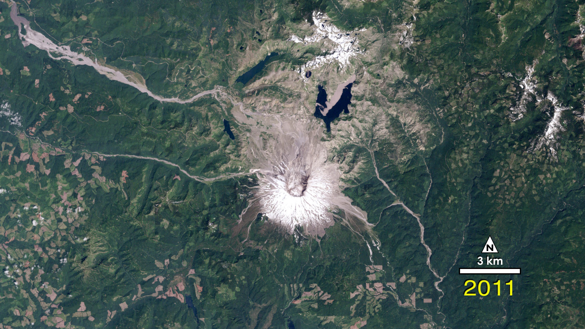
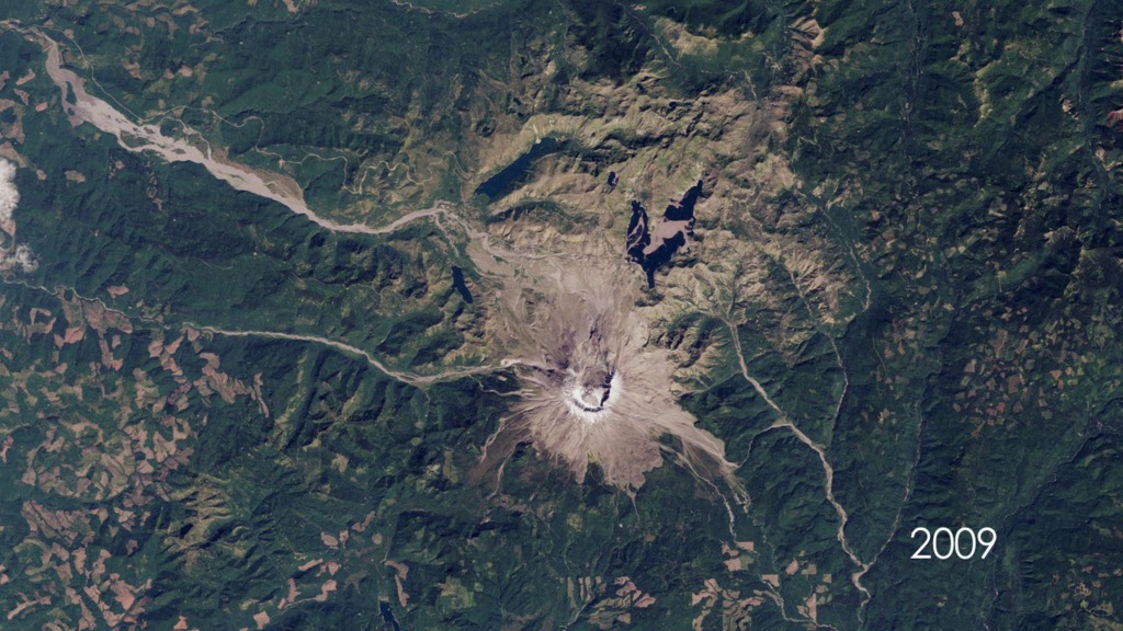
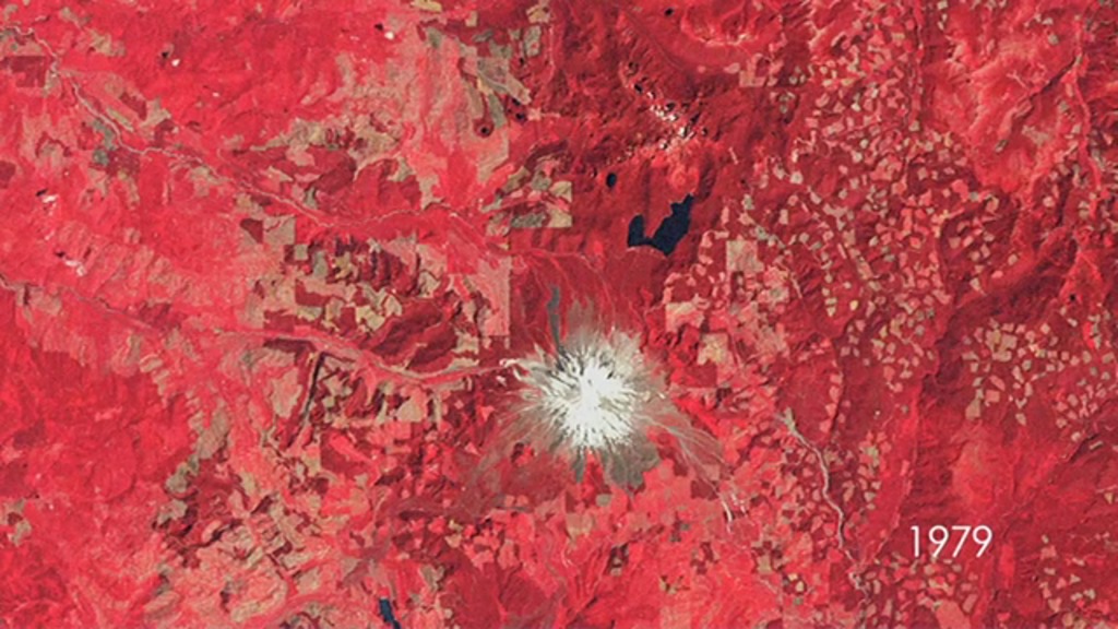
The 1980 Mount Saint Helens eruption was one of the most significant natural disasters in the US in the past half-century. The eruption laid waste to 230 square miles. Landsat captured the extent of the destruction, with grey tones revealing widespread lava flows and ash deposits. Subsequent Landsat images over the years show the spread of vegetation recovery across the site.
Forest Recovering From Mount St. Helens Eruption
There is a newer version of this story located here: https://svs.gsfc.nasa.gov/12612
Newer Version

Credits
Jennifer A. Shoemaker (UMBC): Video Editor
Matthew R. Radcliff (USRA): Video Editor
Jennifer A. Shoemaker (UMBC): Producer
Ellen T. Gray (ADNET Systems, Inc.): Writer
Matthew R. Radcliff (USRA): Video Editor
Jennifer A. Shoemaker (UMBC): Producer
Ellen T. Gray (ADNET Systems, Inc.): Writer
Please give credit for this item to:
NASA/Goddard Space Flight Center
NASA/Goddard Space Flight Center
Images used from NASA's Earth Observatory:
http://earthobservatory.nasa.gov/Features/WorldOfChange/sthelens.php
Landsat is a joint program of NASA and USGS:
http://landsat.usgs.gov
http://www.nasa.gov/landsat
Short URL to share this page:
https://svs.gsfc.nasa.gov/10550
Mission:
Landsat
Data Used:
Note: While we identify the data sets used in these visualizations, we do not store any further details nor the data sets themselves on our site.
This item is part of this series:
Narrated Movies
Keywords:
SVS >> Ecosystem
DLESE >> Geology
SVS >> HDTV
SVS >> Landsat
DLESE >> Natural hazards
DLESE >> Structural geology
SVS >> Volcano
GCMD >> Earth Science >> Solid Earth >> Volcanoes
NASA Science >> Earth
GCMD keywords can be found on the Internet with the following citation: Olsen, L.M., G. Major, K. Shein, J. Scialdone, S. Ritz, T. Stevens, M. Morahan, A. Aleman, R. Vogel, S. Leicester, H. Weir, M. Meaux, S. Grebas, C.Solomon, M. Holland, T. Northcutt, R. A. Restrepo, R. Bilodeau, 2013. NASA/Global Change Master Directory (GCMD) Earth Science Keywords. Version 8.0.0.0.0
https://svs.gsfc.nasa.gov/10550
Mission:
Landsat
Data Used:
Landsat-2/MSS
Landsat-3/MSS
Landsat-4/MSS
Landsat-5/TM
This item is part of this series:
Narrated Movies
Keywords:
SVS >> Ecosystem
DLESE >> Geology
SVS >> HDTV
SVS >> Landsat
DLESE >> Natural hazards
DLESE >> Structural geology
SVS >> Volcano
GCMD >> Earth Science >> Solid Earth >> Volcanoes
NASA Science >> Earth
GCMD keywords can be found on the Internet with the following citation: Olsen, L.M., G. Major, K. Shein, J. Scialdone, S. Ritz, T. Stevens, M. Morahan, A. Aleman, R. Vogel, S. Leicester, H. Weir, M. Meaux, S. Grebas, C.Solomon, M. Holland, T. Northcutt, R. A. Restrepo, R. Bilodeau, 2013. NASA/Global Change Master Directory (GCMD) Earth Science Keywords. Version 8.0.0.0.0


