Push in South of the Hellas Basin Showing Topography from MOLA
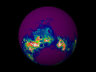
Zoom into the region of Mars just south of the Hellas Basin showing topography data from MOLA. Blue tones represent elevations of less than 2 kilometers, while reddish tones are greater than about 2.8 kilometers, relative to the mean equatorial height of Mars.

A view of the southern hemisphere of Mars showing topography data from MOLA. Blue tones represent elevations of less than 2 kilometers, while reddish tones are greater than about 2.8 kilometers, relative to the mean equatorial height of Mars.

A close-up view of the southern hemisphere of Mars showing topography data from MOLA. Blue tones represent elevations of less than 2 kilometers, while reddish tones are greater than about 2.8 kilometers, relative to the mean equatorial height of Mars.

A close-up view of Martian topography from MOLA showing a region just south of the Hellas Basin. Blue tones represent elevations of less than 2 kilometers, while reddish tones are greater than about 2.8 kilometers, relative to the mean equatorial height of Mars.

A close-up view of Martian topography from MOLA showing the Hellas Basin. Blue tones represent elevations of less than 2 kilometers, while reddish tones are greater than about 2.8 kilometers, relative to the mean equatorial height of Mars.

A close-up view of Martian topography from MOLA showing the Hellas Basin. Blue tones represent elevations of less than 2 kilometers, while reddish tones are greater than about 2.8 kilometers, relative to the mean equatorial height of Mars.
For More Information
Credits
Please give credit for this item to:
NASA/Goddard Space Flight Center
Scientific Visualization Studio
-
Animator
- Tom Biddlecome (Raytheon)
-
Scientist
- David Smith (NASA/GSFC)
Missions
This page is related to the following missions:Series
This page can be found in the following series:Datasets used
-
Topography [MGS: MOLA]
ID: 352
Note: While we identify the data sets used on this page, we do not store any further details, nor the data sets themselves on our site.
Release date
This page was originally published on Monday, November 22, 1999.
This page was last updated on Wednesday, May 3, 2023 at 1:58 PM EDT.
