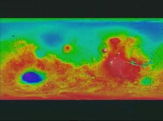
Hellas Crater Flat Flyover (True Color)
Flyover flat map of Mars topography of Hellas Crater with true color texture
\".")
Video slate image reads, "Hellas Flat Flyover
Flying over Hellas crater on a flat map of the Mars surface. True Color Viking imagery data and MOLA terrain elevation data. (10x vertical exaggeration)".
For More Information
Credits
Please give credit for this item to:
NASA/Goddard Space Flight Center Scientific Visualization Studio
-
Animator
-
Greg Shirah
(NASA/GSFC)

-
Greg Shirah
(NASA/GSFC)
-
Scientists
- David Smith (NASA/GSFC)
- Gregory Neumann (Massachusetts Institute of Technology)
Missions
This page is related to the following missions:Series
This page can be found in the following series:Datasets used
-
[MGS: MOLA]
ID: 59 -
[Viking]
ID: 130
Note: While we identify the data sets used on this page, we do not store any further details, nor the data sets themselves on our site.
Alternate Versions
- ID: 657
 Visualization
Release date
This page was originally published on Monday, May 24, 1999.
This page was last updated on Wednesday, May 3, 2023 at 1:59 PM EDT.