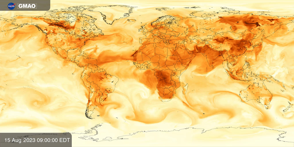
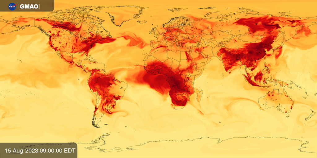
GEOS-FP Near-Surface Temperature
Near surface temperature is calculated by sampling 3-D atmospheric fields from NASA’s GEOS-FP system 3 meters above Earth’s surface. GEOS-FP combines millions of weather observations with a predictive model to create a global best estimate of weather conditions that are used to begin a forecast.
Weather models begin their forecasts by integrating observations from ground stations, aircraft, balloons, and a growing constellation of Earth observing satellites to estimate the most realistic atmospheric state. The Goddard Earth Observing System Forward Processing (GEOS-FP) system is a research model maintained by NASA’s Global Modeling and Assimilation Office to demonstrate innovative new ways to use satellite data to improve predictions of weather, air quality, and greenhouse gases and to help NASA collect new observations of our home planet. Near surface temperature is calculated by sampling model fields at 2 meters (about 6 feet) above Earth’s surface, helping scientists communicate to the general public the air temperatures they encounter. Variations reflect differences in daytime and nighttime temperatures and the influence of large scale weather systems. As the planet warms in response to rising greenhouse gas concentrations, scientists are also tracking changes in the frequency of heat waves and their potential impacts on human health.

Near-Surface Temperature colorbar with semi-transparent background, optimized for Earth Information Center content.

Near-Surface Temperature colorbar.
For More Information
Credits
Please give credit for this item to:
NASA’s Global Modeling and Assimilation Office
-
Visualizer
-
Joseph V. Ardizzone
(NASA/GSFC)

-
Joseph V. Ardizzone
(NASA/GSFC)
Series
This page can be found in the following series:Datasets used
-
GEOS-FP
ID: 1196Documentation: Lucchesi, R., 2018: File Specification for GEOS FP. GMAO Office Note No. 4 (Version 1.2), 61 pp, available from https://gmao.gsfc.nasa.gov/pubs/docs/Lucchesi1203.pdf
This dataset can be found at: https://fluid.nccs.nasa.gov/weather/
See all pages that use this dataset
Note: While we identify the data sets used on this page, we do not store any further details, nor the data sets themselves on our site.
Related
- ID: 5148
 Visualization
 - ID: 5149
 Visualization
 - ID: 5150
 Visualization
 - ID: 5151
 Visualization
 - ID: 5152
 Visualization
 - ID: 5153
 Visualization
 - ID: 5154
 Visualization
Release date
This page was originally published on Tuesday, September 26, 2023.
This page was last updated on Wednesday, June 3, 2026 at 2:00 AM EDT.