Tour of Asteroid Bennu – Visualizations
This first shot of the sequence begins with OSIRIS-REx’s arrival at the asteroid Bennu. A low resolution view of the asteroid is presented and thermal inertia data fades in, representing our initial understanding of the asteroid. The asteroid then spins quickly to serve as a transition to the second shot in the sequence.
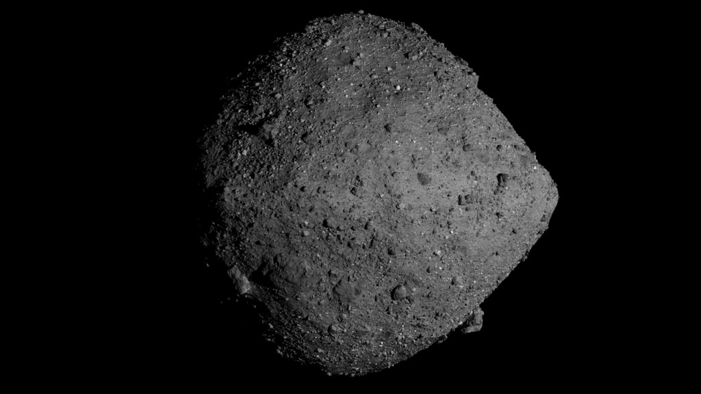
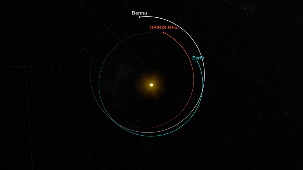
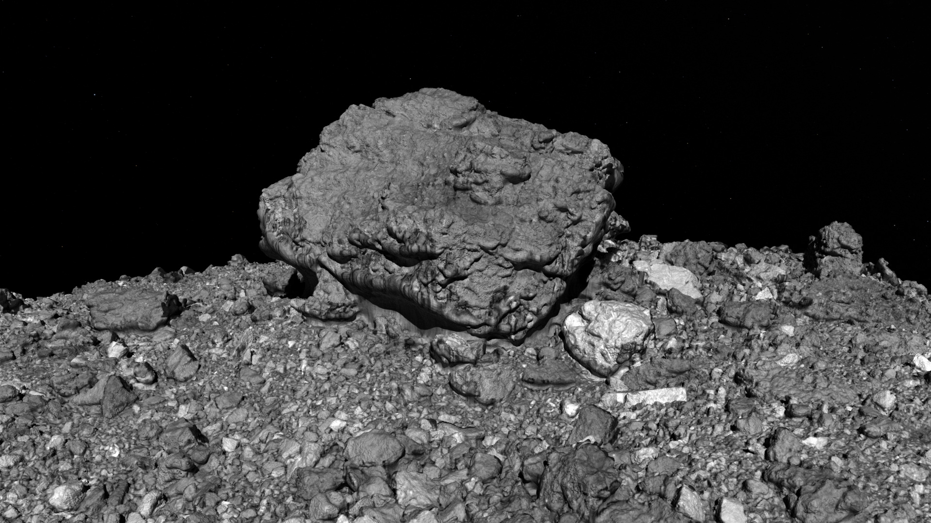
When NASA’s OSIRIS-REx spacecraft arrived at asteroid Bennu in December 2018, its close-up images confirmed what mission planners had predicted nearly two decades before: Bennu is made of loose material weakly clumped together by gravity, and shaped like a spinning top. This major validation, however, was accompanied by a major surprise. Scientists had expected Bennu’s surface to consist of fine-grained material like a sandy beach, but instead OSIRIS-REx was greeted by a rugged world littered with boulders – the size of cars, the size of houses, the size of football fields.
This video explores several interesting features of Bennu. The surface features are presented in vivid detail thanks to detailed terrain data from the OLA instrument and high resolution imagery from the PolyCam instrument.
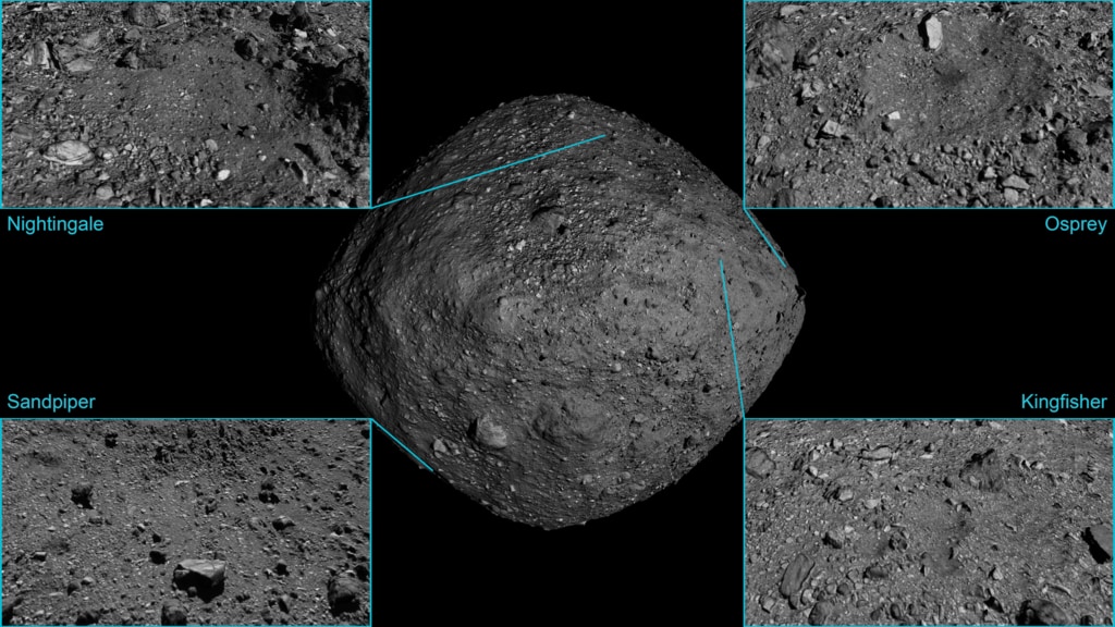
This second shot in the sequence begins with a fast spinning Bennu, matching the end of the first shot in the sequence. As Bennu’s rotation decelerates, a highly detailed view of the asteroid is revealed using 20cm terrain elevation data (OLA) and high resolution imagery (PolyCam). The camera then zooms in and flys over several locations - Simurgh, Roc, Gargoyle, and Ocypete. Each of these locations are presented using 5cm terrain elevation tiles.
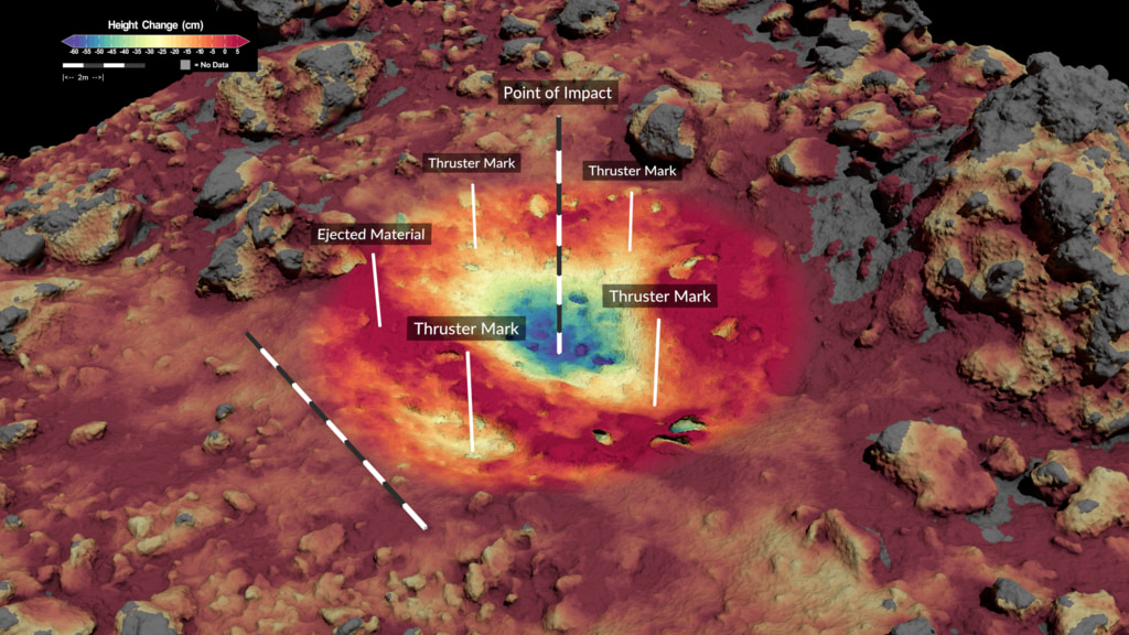
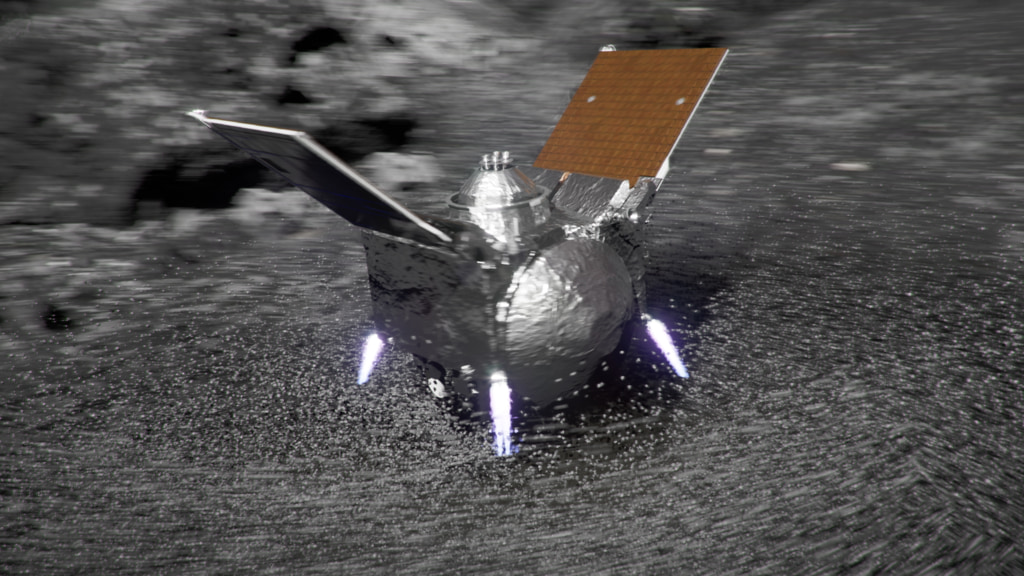
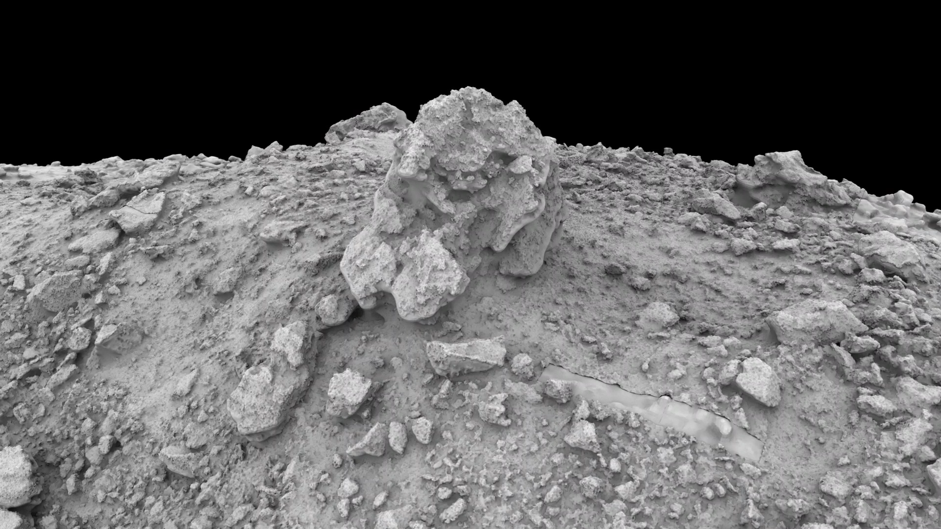
The third shot of the sequence begins with a dramatic reveal of BenBen, the tallest boulder on Bennu. The shot begins in darkness and sunlight sweeps across the surface of the asteroid. The camera rotates down to the horizon to show the height of the boulder before zooming over to a view of two boulders found to contain pyroxene. The camera then zooms back out to a global view and we see OSIRIS-REx in orbit around the asteroid.
Credits
Please give credit for this item to:
NASA's Scientific Visualization Studio
Data provided by NASA/University of Arizona/CSA/York University/Open University/MDA.
-
Visualizer
-
Kel Elkins
(USRA)

-
Kel Elkins
(USRA)
-
Producer
- Dan Gallagher (USRA)
-
Communications lead
- Erin Morton (The University of Arizona)
- Nancy Neal-Jones (NASA/GSFC)
-
Scientist
- Dathon Golish (The University of Arizona/LPL)
Datasets used
-
LIDAR [OSIRIS-REx: OLA]
ID: 1055The OSIRIS-REx Laser Altimeter (OLA) is a scanning LIDAR (Light Detection and Ranging). LIDAR is similar to RADAR, but it uses light instead of radio waves to measure distance. OLA emitted laser pulses at the surface of Bennu, which reflected back from the surface and returned a portion of the laser pulse to the LIDAR detector. By carefully measuring the time difference between the outgoing pulse and the incoming pulse, the distance from the spacecraft to the surface of Bennu was computed using the speed of light. This allowed OLA to provide high-resolution topographical information about Bennu during the mission.
See all pages that use this dataset -
Imagery [OSIRIS-REx: OCAMS]
ID: 1063The OSIRIS-REx Camera Suite (OCAMS) consists of three cameras: PolyCam, MapCam, and SamCam. These cameras captured a wealth of imagery during OSIRIS-REx’s time at asteroid Bennu. To help mission planners select a site on Bennu for sample collection, OCAMS provided global image mapping of the asteroid’s surface and more detailed images of potential sample sites. OCAMS also recorded the sampling event during the touch-and-go (TAG) maneuver.
Credit: NASA/University of Arizona/CSA/York University/MDA
See all pages that use this dataset
Note: While we identify the data sets used on this page, we do not store any further details, nor the data sets themselves on our site.
Related
- ID: 5010
 Visualization
 - ID: 4905
- ID: 4862
 Visualization
 - ID: 13731

- ID: 4857
- ID: 4771
- ID: 4482
Used as a Source In
- ID: 14774
![Scientists studying the Bennu samples have discovered evidence of a wet, salty environment from 4.5 billion years ago that created the molecular building blocks of life.Complete transcript available.Universal Production Music: “Future Tense” by Gresby Race Nash [PRS]; “Take Off” by Nicholas Smith [PRS]; “Big Decision” by Gresby Race Nash [PRS]; “Waiting for the Answer” by Gresby Race Nash [PRS]Watch this video on the NASA Goddard YouTube channel.](/vis/a010000/a014700/a014774/14774-Bennu-Organics-Thumbnail-V4.jpg) Produced Video
Produced Video - ID: 14179
 Produced Video
 - ID: 13908
 Produced Video
 - ID: 13814
 Produced Video
 - ID: 13729
 Produced Video
Release date
This page was originally published on Thursday, October 8, 2020.
This page was last updated on Wednesday, May 14, 2025 at 12:13 AM EDT.