NASA Surveys Hurricane Damage to Puerto Rico's Forests (Data Viz Version)
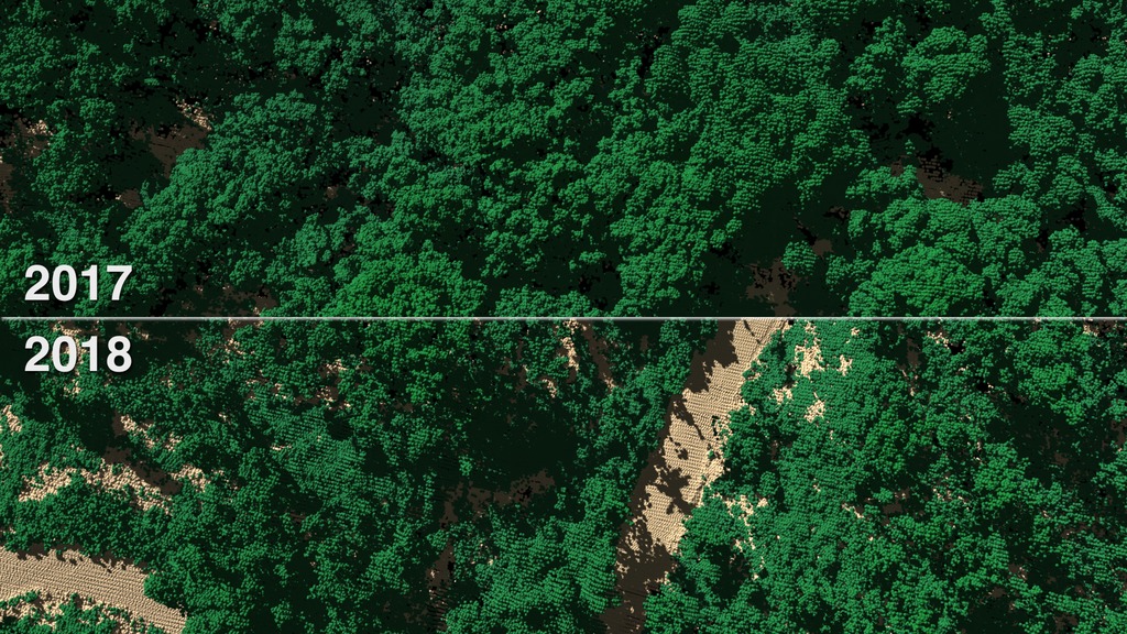
Hurricane Maria transformed the lush rainforests of Puerto Rico leaving lots of openings in the forest canopy. NASA scientists studied the island's forests before and after the storm. Goddard's Lidar, Hyperspectral, and Thermal Imager (G-LiHT) is a portable instrument that maps forest health and structure from a small airplane resulting in detailed 3-D views of the forest. G-LiHT sends out 600,000 laser pulses every second mapping leaves and branches, rocks and streams. Almost 60% of the canopy trees lost branches, snapped in half, or were uprooted. Trees with wide, spreading crowns were reduced to a slender main trunk. Forests in Puerto Rico are now one-third shorter on average, after Hurricane Maria. The disturbances affected the whole ecosystem, from soils and streams to birds and frogs. G-LiHT data will help scientists understand how forests and wildlife respond to future changes.
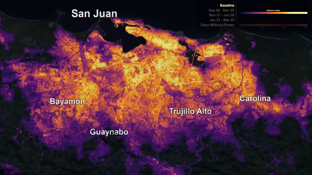
In September 2017, Hurricane Maria struck Puerto Rico head-on as a Category 4 storm with winds topping 155 miles per hour. The storm damaged homes, flooded towns, devastated the island's forests and caused the longest electricity black-out in U.S. history.
Hurricane Maria's lashing rain and winds transformed Puerto Rico's lush tropical rainforest landscape. Research scientist Doug Morton of Goddard was part of the team of NASA researchers who had surveyed Puerto Rico's forests six months before the storm with Goddard’s Lidar, Hyperspectral, and Thermal (G-LiHT) Airborne Imager, a system designed to study the structure and species composition of Puerto Rican forests. Shooting 600,000 laser pulses per second, G-LiHT produces a 3D view of the forest structure in high resolution. In April 2018, post-Maria, they went back and surveyed the same tracks as in 2017.
Comparing the before and after data, the team found that 40 to 60 percent of the tall trees that formed the canopy of the forest either lost large branches, were snapped in half or were uprooted by strong winds.
"Maria gave the island's forests a haircut," said Morton. "The island lost so many large trees that forests were shortened by one-third. We basically saw 60 years' worth of what we would consider natural treefall disturbances happen in one day."
This version was shown at the Association for Computing Machinery (ACM) / Special Interest Group on GRAPHics (SIGGRAPH) Computer Animation Festival (CAF) on July 29, 2019 at the Microsoft Theater in Los Angeles, CA. It will then be part of the ACM/SIGGRAPH CAF traveling show after that.
- Agricultural science
- Agriculture
- Atmosphere
- Atmospheric Phenomena
- Atmospheric science
- Biology
- Biosphere
- Earth Science
- Earth Surface and Interior
- Forest Conservation
- Forest Management
- Forest Science
- Forestry
- Forests
- HDTV
- Hurricane Maria
- Hurricanes
- Lidar
- Location
- Natural hazards
- Puerto Rico
- Terrestrial Ecosystems
- Weather and Atmospheric Dynamics
Credits
Please give credit for this item to:
NASA's Goddard Space Flight Center
-
Data visualizers
-
Alex Kekesi
(Global Science and Technology, Inc.)

-
Kel Elkins
(USRA)
-
Greg Shirah
(NASA/GSFC)
- Horace Mitchell (NASA/GSFC)
-
Alex Kekesi
(Global Science and Technology, Inc.)
-
Producers
- Matthew R. Radcliff (USRA)
- Samson K. Reiny (Wyle Information Systems)
-
Scientists
-
Doug C. Morton
(NASA/GSFC)
- Hyeungu Choi (Global Science and Technology, Inc.)
-
Doug C. Morton
(NASA/GSFC)
-
Technical support
- Laurence Schuler (ADNET Systems, Inc.)
- Ian Jones (ADNET Systems, Inc.)
Series
This page can be found in the following series:Datasets used
-
LiDAR (LiDAR 3D point cloud) [Airplane: G-LiHT]
ID: 965
Note: While we identify the data sets used on this page, we do not store any further details, nor the data sets themselves on our site.
Related
- ID: 12616
 Produced Video
 - ID: 4576
- ID: 12991
![Overview of field expedition to Puerto Rico in April 2018, to survey the recovery of forests since Hurricanes Irma and Maria hit the island seven months before.Complete transcript available.Music: Treehouse Imaginations by Zachary Scott Lemon [BMI]Down Terrace by Damien Deschamps [SACEM]Reloj by Kevin Carbo [BMI]Living Forest by Luca Proietti [SIAE]Watch this video on the NASA Goddard YouTube channel.](/vis/a010000/a012900/a012991/12991-mangroves_and_plane_wing_IMG_0852.jpg) Produced Video
Produced Video
Alternate Versions
- ID: 12590
![To get a detailed look at vegetation and land cover, NASA uses an airborne instrument called Goddard’s Lidar, Hyperspectral and Thermal Airborne Imager, or G-LiHT. From the belly of a small aircraft flying one thousand feet above the trees, G-LiHT collects multiple measurements of forests, including high-resolution photographs, surface temperatures and the heights and structure of the vegetation. Watch this video on the NASA Goddard YouTube channel.Complete transcript available.Music: Letting the Past Go, by Ben Hales [PRS], Matt Hales [PRS]](/vis/a010000/a012500/a012590/12590_Puerto_Rico_lidar_youtube_1080.00248_print.jpg) Produced Video
Produced Video
Sources
- ID: 4621
Used as a Source In
- ID: 13216
![Complete transcript available.Music credits: “Northern Breeze” by Denis Levaillant [SACEM], “Stunning Horizon” by Maxime Lebidois [SACEM], Ronan Maillard [SACEM], “Magnetic Force” by JC Lemay [SACEM] from Killer TracksWatch this video on the NASA Goddard YouTube channel.This video can be freely shared and downloaded. While the video in its entirety can be shared without permission, some individual imagery provided by pond5.com is obtained through permission and may not be excised or remixed in other products. Specific details on stock footage may be found here. For more information on NASA’s media guidelines, visit https://www.nasa.gov/multimedia/guidelines/index.html.Notes on footage:• 0:03 - 0:17 provided by Pond5• 1:38 - 1.43 provided by Pond5• 1:49 - 1:52 provided by Pond5• 2:21 - 1:27 provided by Pond5](/vis/a010000/a013200/a013216/13216_NASA_Has_Eyes_On_The_Atlantic_Hurricane_Season_YouTube.00050_print.jpg) Produced Video
Produced Video
Release date
This page was originally published on Monday, July 29, 2019.
This page was last updated on Wednesday, May 3, 2023 at 1:45 PM EDT.