LRO Ground Track - One Sidereal Month
A satellite's ground track shows the path of its orbit on the surface of the parent body. Lunar Reconnaissance Orbiter will be placed in a nearly circular polar orbit about 50 kilometers (31 miles) above the surface of the Moon, completing each orbit in a little less than two hours. The orientation of this orbit remains fixed in space, relative to the stars, while the Moon slowly rotates beneath it as they travel together around the Earth, allowing LRO to scan the entire surface of the Moon every two weeks.
The animation depicts LRO's ground track over a period of 27.3 days (348 orbits) or one sidereal month, the amount of time it takes the Moon to turn once on its axis, relative to the stars. This is two days shorter than the synodic month, the period of the Moon's phases. The difference arises from the motion of the Earth. While the Moon is orbiting the Earth, the Earth is carrying them both around the Sun, changing the Sun's direction relative to the stars.
Each LRO orbit is separated from the previous one by about one degree of longitude. On the Moon's surface near the equator, this corresponds to a spacing of 30 kilometers (19 miles), but the orbits converge near the poles; at 84 degrees N or S latitude, the ground distance is only 10% of the distance at the equator. At all latitudes, later LRO orbits will fill in the gaps left by earlier ones. Orbits in the latter half of the month depicted in this animation are seen to form a cross-hatch pattern that begins to fill in the gaps left during the first half of the month.
The points at which the orbits cross provide an opportunity to refine our knowledge of LRO's precise position. LOLA, the LRO instrument that maps the lunar terrain by measuring surface elevation, should get the same reading for these crossing points each time it passes over them. If it doesn't, then LRO might not really be at a crossing point, meaning that its actual position differs slightly from its predicted position.
The elevation map comprises low-resolution data from a number of sources, including the Clementine and JAXA/SELENE spacecraft, combined with high-resolution insets for the regions near the poles. The surface color is derived from photographs taken by Clementine.
Ground track animation showing LRO's path over the course of 27 days and 348 orbits.

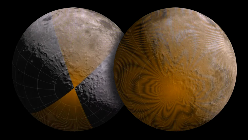
High resolution still image of ground tracks after 7 days.
At 14 days, LRO has completed one scan of the surface and is beginning another one. The orbits are slightly out of phase to fill in the gaps.
LRO completes two scans of the surface every sidereal month. The moire pattern in the ground tracks arises from the way the orbits cross each other at a slight angle.
Credits
Please give credit for this item to:
NASA/Goddard Space Flight Center Scientific Visualization Studio. Some elevation data provided by JAXA/SELENE.
-
Animators
- Ernie Wright (UMBC)
- Marte Newcombe (Global Science and Technology, Inc.)
-
Producer
- Andrew Freeberg (NASA/GSFC)
-
Scientist
- John Keller (NASA/GSFC)
Series
This page can be found in the following series:Datasets used
-
DEM [KAGUYA: Laser Altimeter (LALT)]
ID: 546Formerly known as "SELENE".
See all pages that use this dataset -
ULCN 2005 (Unified Lunar Control Network 2005)
ID: 553The ULCN 2005 (Unified Lunar Control Network 2005) is a lunar control point network that precisely measured 272,931 pieces of data produced by the USGS using existing lunar imagery or data from the Clementine and other observations.
See all pages that use this dataset
Note: While we identify the data sets used on this page, we do not store any further details, nor the data sets themselves on our site.
Related
- ID: 11271
 Produced Video
Release date
This page was originally published on Sunday, June 7, 2009.
This page was last updated on Sunday, October 6, 2024 at 12:00 AM EDT.