2015 Monthly Cloud Fraction
- Visualizations by:
- Amy Moran
- View full credits
Movies
- CF_over_blue_marble_2015_720p.mp4 (1280x720) [3.9 MB]
- CF_over_blue_marble_2015_720p.webm (1280x720) [4.0 MB]
- CF_over_blue_marble_2015_1080p.mp4 (1920x1080) [7.2 MB]
- CF_over_blue_marble_2015_360p.mp4 (640x360) [1.4 MB]
- CF_over_blue_marble_2015_2304p.mp4 (4096x2304) [18.6 MB]
Images
- CF_over_blue_marble_2015_1080p.00001_print.jpg (1024x576) [125.0 KB]
- CF_over_blue_marble_2015_1080p.00001_thm.png (80x40) [6.6 KB]
- CF_over_blue_marble_2015_1080p.00001_searchweb.png (320x180) [79.3 KB]
Frames
- frames/4104x2304_16x9_30p/ (4104x2304) [17.4 KB]
Presentations
- CF_over_blue_marble_2015_30839.key [9.9 MB]
- CF_over_blue_marble_2015_30839.pptx [9.5 MB]
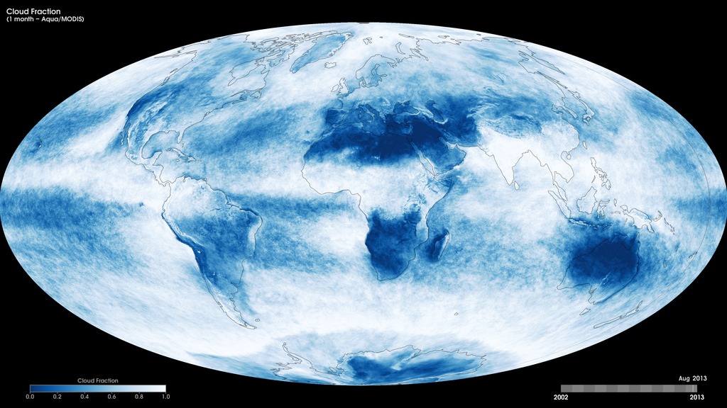
Monthly Cloud Fraction for 2015 (Aqua/MODIS)
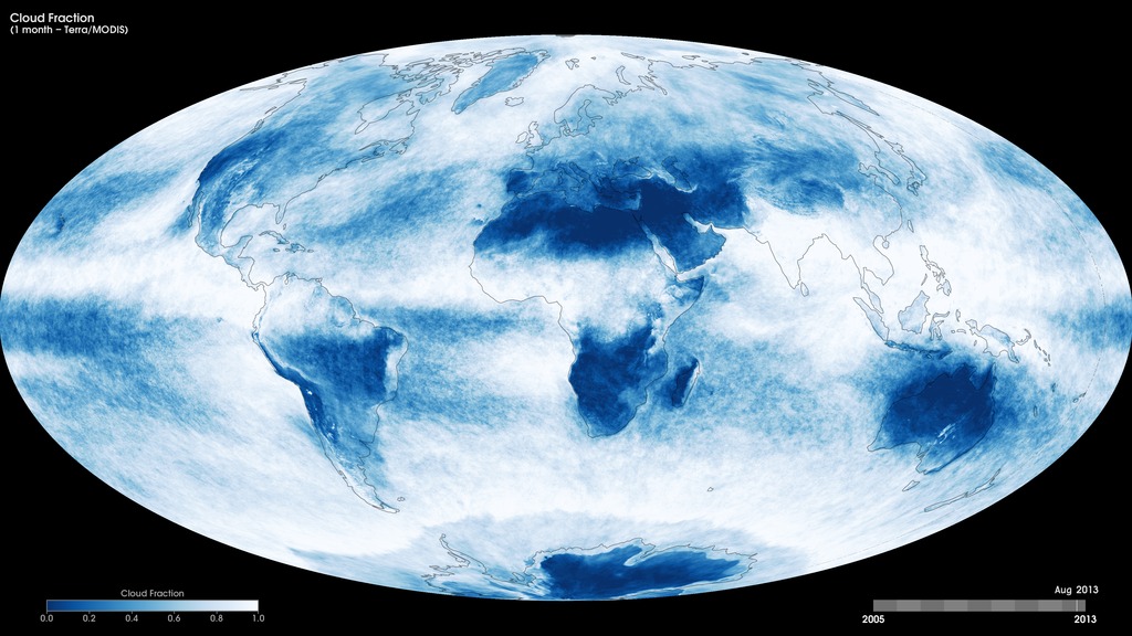
Credits
Please give credit for this item to:
NASA's Goddard Space Flight Center
Animator
- Amy Moran (GST) [Lead]
Missions
This visualization is related to the following missions:Datasets used in this visualization
Aqua (Collected with the MODIS sensor)
Note: While we identify the data sets used in these visualizations, we do not store any further details nor the data sets themselves on our site.
Related pages
2015 Monthly Cloud Top Temperature (Aqua/MODIS)
Dec. 8th, 2016
Read moreMonthly Cloud Top Temperature for 2015 (Aqua/MODIS) Related pages
2015 Monthly Cloud Particle Radius (Aqua/MODIS)
Dec. 6th, 2016
Read moreTo better understand the role of clouds in the Earth's climate system, scientists need two important measurements: cloud optical thickness and cloud particle size. The size of cloud particles is important. In general, smaller particles produce brighter, more reflective clouds, which bounce more sunlight back into space and cool the planet. By carefully quantifying how much shortwave infrared sunlight clouds absorb, scientists can determine the size of the individual particles within clouds. Clouds with larger particles absorb more shortwave infrared light and, conversely, clouds with smaller particles absorb less shortwave infrared light. These maps show the variation in monthly cloud particle radius over the course of 2015, and were produced using data from the Moderate Resolution Imaging Spectroradiometer (MODIS) instrument onboard NASA’s Aqua satellite. Brown shades show where there are smaller cloud particles, while blue-turquoise shades show where there are larger cloud particles. Monthly Cloud Effective Particle Radius - Ice for 2015 (Aqua/MODIS) Monthly Cloud Effective Particle Radius - Liquid for 2015 (Aqua/MODIS) Related pages
2015 Monthly Cloud Optical Thickness (Aqua/MODIS)
Dec. 6th, 2016
Read moreTo better understand the role of clouds in the Earth's climate system, scientists need two important measurements: cloud optical thickness and cloud particle size. A cloud's optical thickness is a measure of attenuation of the light passing through the atmosphere due to the scattering and absorption by cloud droplets. Clouds do not absorb visible wavelengths of sunlight; rather, clouds scatter and reflect most visible light. The higher a cloud's optical thickness, the more sunlight the cloud is scattering and reflecting. These maps show the variation in monthly cloud optical thickness over the course of 2015, produced using data from the Moderate Resolution Imaging Spectroradiometer (MODIS) instrument onboard NASA’s Aqua satellite. Dark blue shades indicate areas where there are low cloud-optical-thickness values, while white shades indicate high values (i.e., greater attenuation caused by the scattering and absorption from cloud droplets). Monthly Cloud Optical Thicknes - Ice for 2015 (Aqua/MODIS) Monthly Cloud Optical Thicknes - Liquid for 2015 (Aqua/MODIS) Related pages
Monthly Cloud Fraction (Terra/MODIS)
Oct. 24th, 2013
Read moreCloud fraction is the measurement scientists use to determine how much of the Earth is covered by clouds. The measurement is important because clouds play a large role in regulating the amount of energy that reaches the Earth from the sun as well as the amount of energy that the Earth reflects and emits back into space. These maps show monthly cloud fraction from January 2005 to the present, produced using data from the Moderate Resolution Imaging Spectroradiometer (MODIS) instrument onboard NASA’s Terra satellite. Like a digital camera, MODIS collects information in gridded boxes or pixels. Each box covers one square kilometer. Cloud fraction is the portion of each pixel that is covered by clouds. Scientists make this measurement by counting the number of pixels in a 25-square-kilometer box (5 pixels tall by 5 pixels wide) that are cloudy and dividing that number by 25. Scientists use these measurements to better understand how much of the Earth is covered by clouds and how changes in Earth’s climate may alter the amount and types of clouds that form. Monthly Terra/MODIS cloud fraction, January 2005 to the present. For More InformationSee [neo.sci.gsfc.nasa.gov/Search.html?datasetId=MODAL2_M_CLD_FR](neo.sci.gsfc.nasa.gov/Search.html?datasetId=MODAL2_M_CLD_FR) Related pages
Monthly Cloud Fraction (Aqua/MODIS)
Oct. 24th, 2013
Read moreCloud fraction is the measurement scientists use to determine how much of the Earth is covered by clouds. The measurement is important because clouds play a large role in regulating the amount of energy that reaches the Earth from the sun as well as the amount of energy that the Earth reflects and emits back into space. These maps show monthly cloud fraction from July 2002 to the present, produced using data from the Moderate Resolution Imaging Spectroradiometer (MODIS) instrument onboard NASA’s Terra satellite. Like a digital camera, MODIS collects information in gridded boxes or pixels. Each box covers one square kilometer. Cloud fraction is the portion of each pixel that is covered by clouds. Scientists make this measurement by counting the number of pixels in a 25-square-kilometer box (5 pixels tall by 5 pixels wide) that are cloudy and dividing that number by 25. Scientists use these measurements to better understand how much of the Earth is covered by clouds and how changes in Earth’s climate may alter the amount and types of clouds that form. Monthly Aqua/MODIS cloud fraction, July 2002 to the present. For More InformationSee [neo.sci.gsfc.nasa.gov/Search.html?datasetId=MYDAL2_M_CLD_FR](neo.sci.gsfc.nasa.gov/Search.html?datasetId=MYDAL2_M_CLD_FR) Related pages
Cloud Fraction
Nov. 24th, 2019
Read moreCloud fraction is the measurement scientists use to determine how much of the Earth is covered by clouds. The measurement is important because clouds play a large role in regulating the amount of energy that reaches the Earth from the sun as well as the amount of energy that the Earth reflects and emits back into space. These maps show monthly cloud fraction from February 2000 to the present, produced using data from the Moderate Resolution Imaging Spectroradiometer (MODIS) instrument onboard NASA’s Terra satellite. Like a digital camera, MODIS collects information in gridded boxes or pixels. Each box covers one square kilometer. Cloud fraction is the portion of each pixel that is covered by clouds. Scientists make this measurement by counting the number of pixels in a 25-square-kilometer box (5 pixels tall by 5 pixels wide) that are cloudy and dividing that number by 25. Scientists use these measurements to better understand how much of the Earth is covered by clouds and how changes in Earth’s climate may alter the amount and types of clouds that form. Terra/MODIS cloud fraction, February 2000 to present For More InformationSee [https://ladsweb.modaps.eosdis.nasa.gov/missions-and-measurements/products/MOD08_M3/](https://ladsweb.modaps.eosdis.nasa.gov/missions-and-measurements/products/MOD08_M3/) Related pages