Atmospheric Gravity Waves Imagery
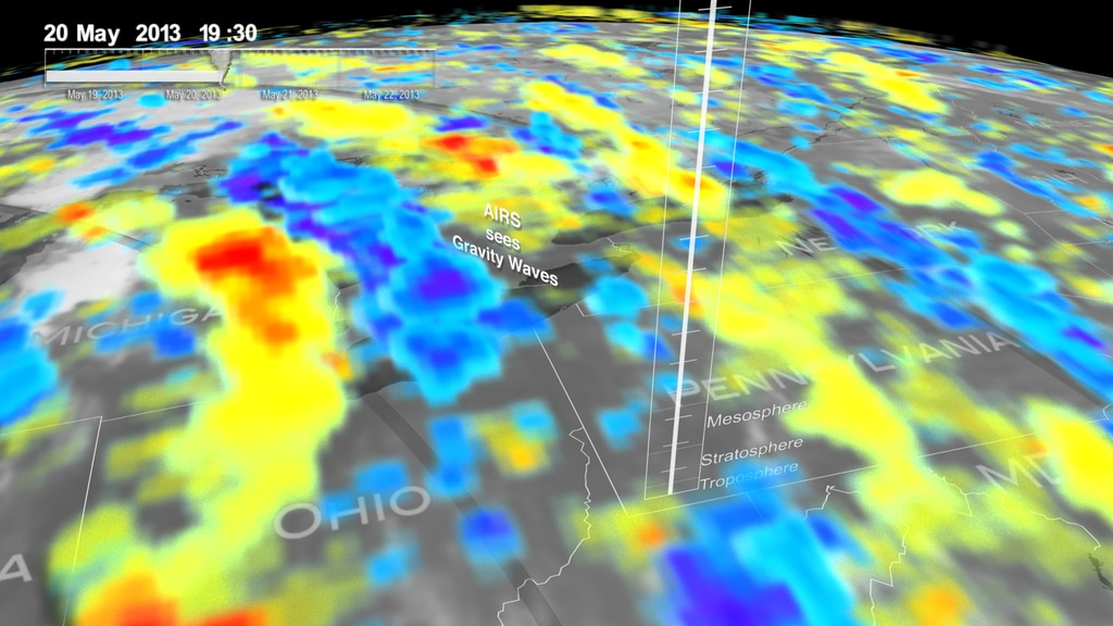
Atmospheric gravity waves are similar to what happens when you drop a stone into a calm pond, but they roll through the air and cloud tops instead of water. Just like waves form in the ocean or a lake when water is disturbed, waves also form in the atmosphere when air is disturbed. They form when air is forced upward by hills or mountains into a layer of stable air in the atmosphere. Gravity causes the air to fall back down, and it begins to oscillate, creating a ripple effect. Wind flowing over the Rocky Mountains, for example, can create gravity waves that are felt as turbulence on an airplane.

From the vantage point of the International Space Station, astronauts frequently observe atmospheric and surface phenomena in ways that are impossible to view from the ground. Two such phenomena—gravity waves and sunglint—are illustrated in this photograph of northeastern Lake Superior.
Gravity waves are produced when moisture-laden air encounters imbalances in air density, such as might be expected when cool air flows over warmer air. This can cause the flowing air to oscillate up and down as it moves, causing clouds to condense as the air rises and cools and to evaporate away as the air sinks and warms. This produces parallel bands of clouds oriented perpendicular to the wind direction. The orientation of the cloud bands in this image, parallel to the coastlines, suggests that air flowing off of the land surfaces to the north is interacting with moist, stable air over the lake surface, creating gravity waves.
Caption by William L. Stefanov, Jacobs/JETS and Michael H. Trenchard, Barrios/JETS, both at NASA-JSC. Image Credit: NASA/ISS
Two unique types of waves ripple through the Indian Ocean in this spectacular true-color Moderate Resolution Imaging Spectroradiometer (MODIS) image, taken by the Terra satellite on November 11, 2003. In the upper western portion of the image, atmospheric gravity waves reveal themselves in double, overlapping arcs of clouds. In the eastern part of the scene, a mixture of wave patterns caused by atmospheric gravity waves and internal ocean waves fans out from the coast. Sunglint (sunlight reflecting off of rough surface waters and back into MODIS’s “eye”) slants across this portion of the image, which makes the different types of waves easier to see.
Image Credit: Jacques Descloitres, MODIS Rapid Response Team, NASA/GSFC
On May 23, 2005, the Moderate Resolution Imaging Spectroradiometer (MODIS) on NASA’s Terra satellite captured this image of a large-scale, overlapping wave pattern in the sunglint region of an image of the Arabian Sea. The wave pattern seen in the image is not from large ocean waves, however. The pattern is the “impression” of atmospheric gravity waves on the surface of the ocean.
As the name implies, atmospheric gravity waves form when buoyancy pushes air up, and gravity pulls it back down. On its descent into the low-point of the wave (the trough), the air touches the surface of the ocean, roughening the water. The long, vertical dark lines show where the troughs of gravity waves have roughened the surface. The brighter regions show the crests of the atmospheric waves. Beneath the crests, the water is calm and reflects light directly back toward MODIS.
Image Credit: Jeff Schmaltz MODIS Rapid Response Team, NASA-GSFC
On June 26, 2016, the Moderate Resolution Imaging Spectroradiometer (MODIS) on NASA’s Terra satellite acquired this natural-color image of cloud gravity waves off the coast of Angola and Namibia. Similar to a boat’s wake, which forms as the water is pushed upward by the boat and pulled downward again by gravity, these clouds are formed by the rise and fall of colliding air columns.
In this image, the clouds form several hundred kilometers off the coast, but at times when the air is less dry or westerly winds are less strong, clouds can be seen hugging the coast.
Caption by: Pola Lem. Image Credit: NASA Earth Observatory image by Jesse Allen, using data from the Land Atmosphere Near real-time Capability for EOS (LANCE).
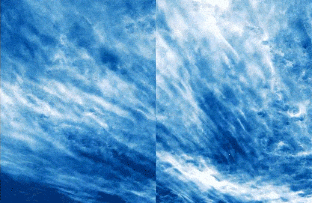
When the Moderate Resolution Imaging Spectroradiometer (MODIS) on NASA’s Terra satellite captured this natural-color image on October 4, 2020, a series of undulating cloud bands—an undular bore—rippled over the Pacific Ocean near Baja California.
Wave clouds (sometimes called undulatus or billow clouds) like these are the product of atmospheric gravity waves. They typically form when something forces a mass of air upward. The air cools as it rises and, if there is enough moisture in the air, the water condenses and forms clouds. After the air has passed over the obstacle, it typically sinks downward again. The air warms as it descends, preventing clouds from forming. But like ripples on a pond, the initial disturbance creates a propagating wave that continues to spread, causing air to rise and drop again and again until the wave dissipates. The end result is long lines of clouds that mark the crests of the waves, with cloud-free areas between them that correspond to the troughs of the waves.
Caption by Adam Voiland. Image Credit: NASA Earth Observatory image by Joshua Stevens, using MODIS data from NASA EOSDIS/LANCE and GIBS/Worldview.
This image shows a large, overlapping wave pattern in the sunglint region of an image of Indonesia (the islands at the top of the image) and Australia (the landmass in the bottom of the image).
This image shows a large, overlapping wave pattern in the sunglint region of an image of Indonesia (the islands at the top of the image) and Australia (the landmass in the bottom of the image).
Image Credit: NASA/GSFC/MODIS Land Rapid Response Team and Jeff Schmaltz
The Moderate Resolution Imaging Spectroradiometer (MODIS) on NASA’s Terra satellite acquired this image of mountain-wave clouds near the Auckland Islands. The wave-driven clouds are flowing in an easterly direction on the lee side of the small archipelago about 450 kilometers (280 miles) south of New Zealand’s South Island.
The islands are known for their rugged terrain, and some of the peaks—including Mount Raynal, Mount D’Urville, and Mount Easton—surpass 600 meters (2,000 feet). With these summits poking well above the ocean surface, the islands disturbed the smooth, easterly flow of air and created atmospheric gravity waves and wave clouds that rippled through the atmosphere. The presence of clouds makes it possible to see the waves.
Caption by Adam Voiland. Image Credit: Jeff Schmaltz, LANCE/EOSDIS Rapid Response.
When NASA’s Aqua satellite passed over the Gulf of Sidra on July 9, 2023, it was positioned such that sunlight reflected off the ocean at the same angle that the satellite’s sensor viewed it. The result was an optical phenomenon that gave ocean surfaces a bright gleam known as sunglint.
On the edge of the sunglint region, the sensor also observed long curved bands of alternating light and dark stripes caused by atmospheric gravity waves. Such waves form when stratified air layers are disturbed by topography, or when different air masses interact.
Caption by Adam Voiland. Image Credit: NASA Earth Observatory images by Wanmei Liang, using MODIS data from NASA EOSDIS LANCE and GIBS/Worldview.
In this natural-color image from the Multi-angle Imaging SpectroRadiometer (MISR), a fingerprint-like gravity wave feature occurs over a deck of marine stratocumulus clouds. Similar to the ripples that occur when a pebble is thrown into a still pond, such “gravity waves” sometimes appear when the relatively stable and stratified air masses associated with stratocumulus cloud layers are disturbed by a vertical trigger from the underlying terrain, or by a thunderstorm updraft or some other vertical wind shear.
The stratocumulus cellular clouds that underlie the wave feature are associated with sinking air that is strongly cooled at the level of the cloud-tops—such clouds are common over mid-latitude oceans when the air is unperturbed by cyclonic or frontal activity. This image is centered over the Indian Ocean (at about 38.9° South, 80.6° East), and was acquired on October 29, 2003.
Caption by Clare Averill (Raytheon/JPL). Image Credit: NASA/GSFC/LaRC/JPL, MISR Team.
Credits
Please give credit for this item to:
NASA's Goddard Space Flight Center
-
Producer
- Beth Anthony (KBR Wyle Services, LLC)
Missions
This page is related to the following missions:Related
- ID: 14494
 Produced Video
 - ID: 4683
 Visualization
 - ID: 13073
 Produced Video
Used as a Source In
- ID: 14464
![Complete transcript available.Music Credit: “Genosequence” by Alessandro Rizzo [PRS], Elliot Greenway Ireland [PRS] via Universal Production Music](/vis/a010000/a014400/a014464/14464_AWEOverview_Thumb.png) Produced Video
Produced Video
Release date
This page was originally published on Wednesday, October 25, 2023.
This page was last updated on Thursday, October 26, 2023 at 9:29 AM EDT.