NASA Catches Hurricanes Jose and Maria
Music: "Tradition-Innovation," Philippe Lhommet, KOKA Media
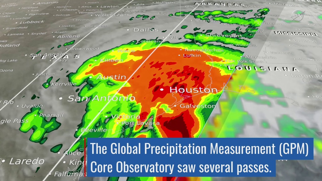
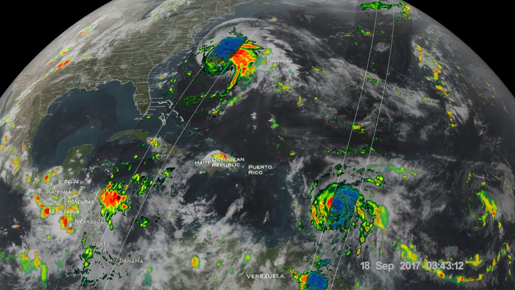
The Global Precipitation Measurement (GPM) mission shows the rainfall distribution for two major storms churning in the Atlantic and Caribbean basins. The visualization shows Hurricane Jose as it continues to slowly move northward off the US East Coast east of the Outer Banks of North Carolina. At one time, Jose was a powerful Category 4 border line Category 5 storm with maximum sustained winds reported at 155 mph by the National Hurricane Center back on the 9th of September as it was approaching the northern Leeward Islands. Jose passed northeast of the Leeward Islands as a Category 4 storm on a northwest track and then began to weaken due to the effects of northerly wind shear. Remaining over warm water allowed Jose to strengthen back into a hurricane on September 15th as wind shear across the storm diminished. At this time, Jose was still only midway between the central Bahamas and Bermuda, having just completed its loop, and moving to the northwest. On the 16th, Jose turned northward as it moved around the western edge of a ridge of high pressure near Bermuda and began to parallel the US East Coast well away from shore. An overpass by the GPM Core Observatory captured an image of Jose overnight at 3:36 UTC 18 September (11:36 pm EST 17 September) as the storm was moving due north at 9 mph well off shore from the coast of North Carolina. The GPM image estimated areas of very heavy rain on the order of 75 mm/hr (~3 inches per hour).
The GPM Core Observatory satellite also had an excellent view of Hurricane Maria when it passed almost directly above the hurricane on September 17, 2017 at 1001 PM AST (September 18, 2017 0201 UTC). GPM's Microwave Imager (GMI) and Dual-Frequency Precipitation Radar (DPR) showed that Maria had well defined bands of precipitation rotating around the eye of the tropical cyclone. GPM's radar (DPR Ku band) found rain falling at a rate of over 6.44 inches (163.7 mm) per hour in one of these extremely powerful storms northeast of Maria's eye. Intense thunderstorms were found towering to above 9.7 miles (15.7 km). This kind of chimney cloud is also called a "hot tower" (as it releases a huge quantity of latent heat by condensation). These tall thunderstorms in the eye wall are often a sign that a tropical cyclone is becoming more powerful. Maria rapidly intensified following this view to a Category 5 storm on September 19th.
Credits
Please give credit for this item to:
NASA's Goddard Space Flight Center
-
Producer
- Ryan Fitzgibbons (USRA)
-
Visualizers
-
Kel Elkins
(USRA)

-
Alex Kekesi
(Global Science and Technology, Inc.)
-
Kel Elkins
(USRA)
-
Writer
- Stephen J. Munchak (University of Maryland)
-
Scientists
-
George Huffman
(NASA/GSFC)
- Stephen J. Munchak (University of Maryland)
- Dalia B Kirschbaum (NASA/GSFC)
-
George Huffman
(NASA/GSFC)
Related
- ID: 12738
![Watch this video on the NASA Goddard YouTube channel.Complete transcript available.Music credits: 'Micro Currents' by Jean-Patrick Voindrot [SACEM], 'Sink Deep' by Andrew Michael Britton [PRS], David Stephen Goldsmith [PRS], Mikey Rowe [PRS] from Killer Tracks.](/vis/a010000/a012700/a012738/LARGE_MP4-12738_RapidIntensification_large.00084_print.jpg) Produced Video
Produced Video - ID: 12697
 Produced Video
Sources
- ID: 4585
Used as a Source In
- ID: 12733
 Produced Video
Release date
This page was originally published on Wednesday, September 20, 2017.
This page was last updated on Wednesday, May 3, 2023 at 1:47 PM EDT.