Lights Out
- Visualizations by:
- Kel Elkins
- Written by:
- Ellen T. Gray
- Scientific consulting by:
- Miguel Román
- Produced by:
- Matthew Radcliff
- View full credits

Watch the lights come back on after the longest electricity black-out in U.S. history.
Movies
- 12616_BlackMarblePR_FINAL_high.mp4 (1280x720) [47.7 MB]
- 12616_BlackMarblePR_FINAL_high.webm (1280x720) [14.8 MB]
Images
- 12616_BlackMarblePR_1024x576_print.jpg (1024x576) [85.2 KB]
- 12616_BlackMarblePR_1024x576.jpg (1024x576) [148.9 KB]
- 12616_BlackMarblePR.png (3840x2160) [10.1 MB]
- 12616_BlackMarblePR_1024x576_thm.png (80x40) [8.6 KB]
- 12616_BlackMarblePR_1024x576_searchweb.png (320x180) [125.5 KB]
Files
- a012396_12616_iPad_movie_BlackMarblePR_FINAL/12616_BlackMarblePR_FINAL.m3u8 [1.6 KB]
Watch Puerto Rico's lights before and in the months after Hurricane Maria as electricity is slowly restored.
Movies
- 4658_BM_Puerto_Rico_1080_VX-300168_high.mp4 (1280x720) [114.7 MB]
- 4658_BM_Puerto_Rico_1080_VX-300168_high.webm (1280x720) [32.0 MB]
Images
- bmhd_11_0940_1024x576.jpg (1024x576) [55.0 KB]
- bmhd_11_0940.tif (3840x2160) [31.7 MB]
Files
- a012396_4658_iPad_movie_BM_Puerto_Rico_1080_VX-300168/4658_BM_Puerto_Rico_1080_VX-300168.m3u8 [1.6 KB]
Tour before and after images of Puerto Rico's cities and towns.

Before Hurricane Maria, Puerto Rico's urban areas, primarily around the coasts, are brightly lit.

On September 20th, Hurricane Maria struck Puerto Rico, its path shown in red. The storm knocked out power for nearly the entire island.

The average light level three to four months after Maria shows urban centers beginning to recover.

The average light level five to six months after Maria shows power mostly restored, though rural areas still lag behind.
For More Information
See NASA.gov
Credits
Please give credit for this item to:
NASA's Scientific Visualization Studio
Animator
- Kel Elkins (USRA) [Lead]
Writer
- Ellen T. Gray (NASA/HQ) [Lead]
Scientist
- Miguel Román (USRA) [Lead]
Producer
- Matthew Radcliff (KBRwyle) [Lead]
Related pages
The Night Electric
Dec. 26th, 2012
Read moreA satellite looks back at Earth and sees a constellation of bustling cities and remote towns. It took 312 satellite orbits and 2.5 terabytes of clear, cloud-free data to create this composite view of Earth at night. A narrated tour takes you in close for highlights of what is being called "The Black Marble." The Nile River Valley and Delta comprises 5 percent of Egypt's land area, but provides a home to 97 percent of its population. While modernized South Korea gleams with city lights, North Korea appears dark. Lighted fishing boats dot the Yellow Sea. Night light images, like this one of South America, distinguish urban versus rural areas and show where major population centers are. Images like this of the U.S. have been used for research in sociology, economics, and urban planning. For More InformationSee [NASA Earth Observatory](http://earthobservatory.nasa.gov/Features/NightLights/?src=features-hp) Related pages
Black Marble View of Puerto Rico After Hurricane Maria
Dec. 10th, 2018
Read moreScientist Miguel Román and colleagues combined NASA's Black Marble night lights data product from the NASA/NOAA Suomi National Polar-orbiting Partnership with data from USGS-NASA Landsat satellites and other sources to produce a neighborhood-scale map of energy use in communities across Puerto Rico as electricity was restored after Hurricane Maria in 2017.Complete transcript available.Watch this video on the NASA Goddard YouTube channel. Música: Formulas and Equations, Richard Andrew CanavanComplete transcript available.El científico Miguel Román y sus colegas combinaron el producto de datos de luces nocturnas Black Marble de la NASA, proveniente del satélite Suomi National Polar-orbiting Partnership de la NASA y NOAA, con datos del satélite Landsat de USGS-NASA y otras fuentes para producir un mapa a escala vecinal del uso de electricidad en comunidades de Puerto Rico a medida que la electricidad iba siendo restaurada tras el paso del Huracán María en 2017.Mira este video en el canal en español de la NASA en YouTube (youtube.com/NASA_ES) At night, a satellite's view of Earth lights up in bright strings of roads dotted with pearl-like cities and towns as humans take center stage in artificial light. In Puerto Rico, during Hurricane Maria, the entire island's lights went out. In the days, weeks, and months that followed, research physical scientist Miguel Román at NASA's Goddard Space Flight Center in Greenbelt, Maryland, and his colleagues combined NASA's Black Marble night lights data product from the NASA/NOAA Suomi National Polar-orbiting Partnership satellite with USGS-NASA Landsat data and Google's OpenStreetMap to develop a neighborhood-scale map of energy use in communities across Puerto Rico as the electricity grid was slowly restored. They then analyzed the relationship between restoration rates in terms of days without electricity and the remoteness of communities from major cities.En Español:Por la noche, las vistas de la Tierra captadas por satélites se iluminan, mostrando brillantes collares consistentes de carreteras salpicadas por ciudades y pueblos que se asemejan a relucientes perlas. Las actividad humana, reflejada en el uso de luces artificiales, toma un papel protagonista. En Puerto Rico, durante el Huracán María, todas las luces de la isla se apagaron.En los días, semanas y meses que siguieron, el investigador Miguel Román del Centro de Vuelo Espacial Goddard de la NASA en Greenbelt, Maryland, y sus colegas combinaron el producto de datos de luces nocturnas Black Marble de la NASA, proveniente del satélite Suomi National Polar-orbiting Partnership de la NASA y NOAA, con datos del satélite Landsat de USGS-NASA y con OpenStreetMap de Google. Usando todos estos datos, los investigadores crearon un mapa que mostraba el uso de energía a nivel de vecindad en comunidades de todo Puerto Rico a medida que la red eléctrica iba siendo lentamente reestablecida. A continuación, analizaron la relación existente entre los niveles de restablecimiento (en términos de días sin electricidad) y la lejanía de las comunidades respecto a los grandes centros urbanos. Related pages
NASA's Black Marble night lights used to examine disaster recovery in Puerto Rico
Dec. 8th, 2018
Read moreThis visualization starts with a global view of hurricane Maria hitting Puerto Rico. We then zoom in to Puerto Rico to compare the standard night lights dataset to a new, high definition version of nights lights. After the hurricane passes over the island, we see a massive drop in night light intensity due to loss of power. After showing night light levels over several stages of hurricane recovery, we transition to a 'Days Without Power' dataset. The camera then zooms in to several locations around the island to examine each stage of recovery in more detail. This visualization starts with a global view of hurricane Maria hitting Puerto Rico. We then zoom in to Puerto Rico to compare the standard night lights dataset to a new, high definition version of nights lights. After the hurricane passes over the island, we see a massive drop in night light intensity due to loss of power. After showing night light levels over several stages of hurricane recovery, we transition to a 'Days Without Power' dataset. The camera then zooms in to several locations around the island to examine each stage of recovery in more detail. This version has no legend/labels. Still image - Hurricane Maria just after passing over Puerto Rico Still image - Puerto Rico night lights after Hurricane Maria passes over (path shown here in red) Color bar for night light intensity Color bar for number of days without power Print resolution still - This view of Puerto Rico shows number of days without power. Greens and yellows are fewer days (0-60), and reds and pinks are more days (120-180). (With and without city labels) Print resolution still - This view of Puerto Rico shows number of days without power. Greens and yellows are fewer days (0-60), and reds and pinks are more days (120-180). Print resolution still - This view of Puerto Rico shows number of days without power. Greens and yellows are fewer days (0-60), and reds and pinks are more days (120-180). Print resolution still - Baseline (pre-storm) view of Puerto Rico night lights. (With and without city labels) Print resolution still - Average night lights 2 months (Sep 20 - Nov 20) after Hurricane Maria passed over Puerto Rico. (With and without city labels) Print resolution still - Average night lights 3-4 months (Nov 21- Jan 20) after Hurricane Maria hit Puerto Rico. (With and without city labels) Print resolution still - Average night lights 5-6 months (Jan 21- Mar 20) after Hurricane Maria hit Puerto Rico. (With and without city labels) Print resolution still - Baseline (pre-storm) view of San Juan night lights. Print resolution still - Average San Juan night lights 2 months (Sep 20 - Nov 20) after Hurricane Maria passed over Puerto Rico. 
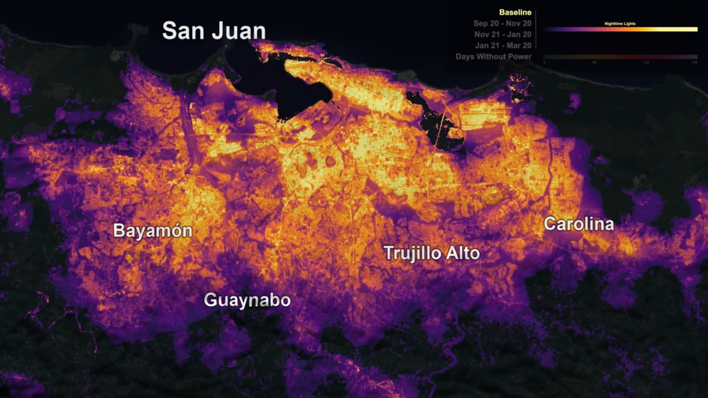
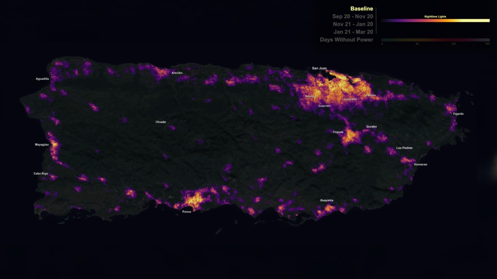
At night, Earth is lit up in bright strings of roads dotted with pearl-like cities and towns as human-made artificial light takes center stage. During Hurricane Maria, Puerto Rico's lights went out.In the days, weeks, and months that followed, research physical scientist Miguel Román at NASA's Goddard Space Flight Center in Greenbelt, Maryland, and his colleagues combined NASA's Black Marble night lights data product from the NASA/NOAA Suomi National Polar-orbiting Partnership satellite with USGS-NASA Landsat data and Google's OpenStreetMap to develop a neighborhood-scale map of energy use in communities across Puerto Rico as the electricity grid was slowly restored. They then analyzed the relationship between restoration rates in terms of days without electricity and the remoteness of communities from major cities. Related pages