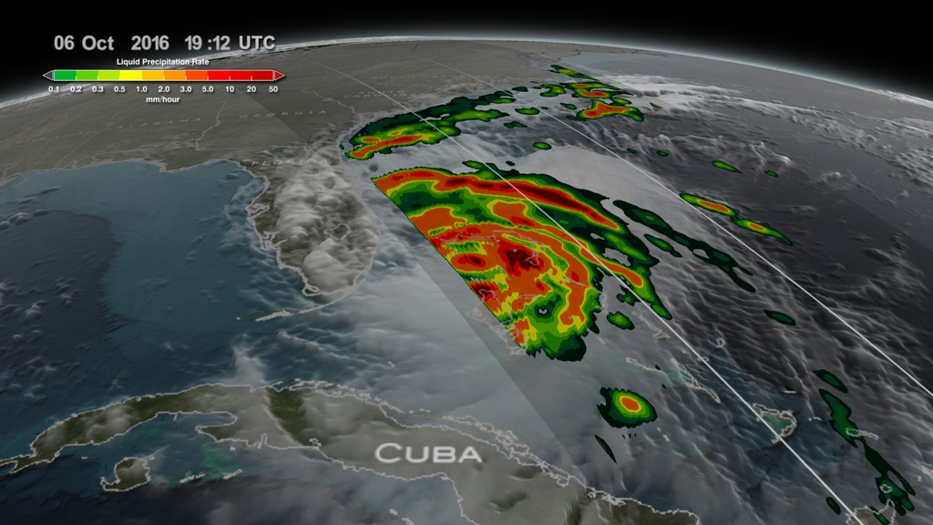
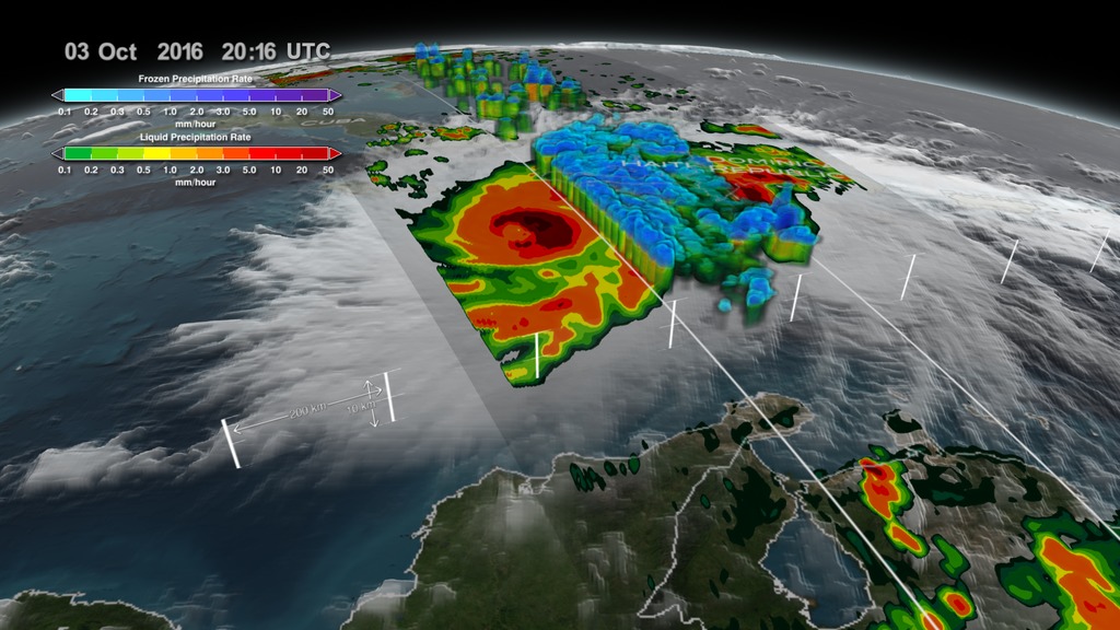
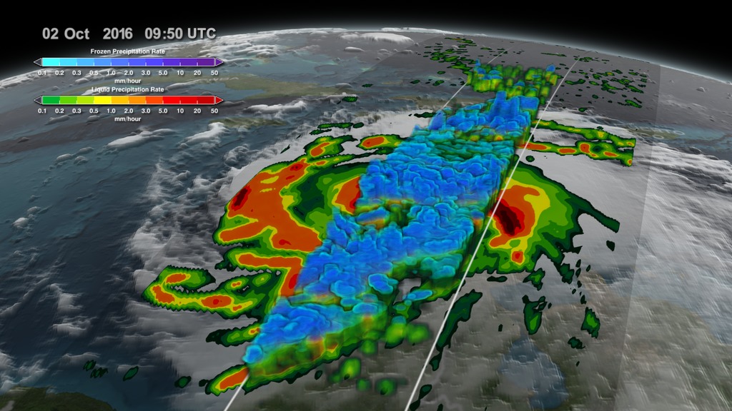
NASA Satellite Captures 3-D View Of Hurricane Matthew
NASA’s Global Precipitation Measurement Mission or GPM core satellite captured Hurricane Matthew in 3-D as it made landfall on Haiti and as it travelled up to the Florida coast. GPM flew directly over the storm several times between October 2 - October 6, 2016. The most recent view on October 6 reveals massive amounts of rainfall being produced by the storm as it approaches Florida.
The GPM core satellite carries two instruments that show the location and intensity of rain and snow, which defines a crucial part of the storm structure – and how it will behave. The GPM Microwave Imager sees through the tops of clouds to observe how much and where precipitation occurs, and the Dual-frequency Precipitation Radar observes precise details of precipitation in 3-dimensions.
For more information about the science behind Hurricane Matthew visit: http://www.nasa.gov/matthew
For the latest storm warnings and safety information please consult your local news channels and the National Hurricane Center: http://www.nhc.noaa.gov/
Video credit: NASA's Goddard Space Flight Center/Joy Ng
Music credit: Diamond Skies by Andrew Skeet [PRS], Anthony Phillips [PRS] from the KillerTracks catalog
NASA Calculates Matthew's Heavy Rains - Close Up
NASA satellite data was used to provide estimates of Hurricane Matthew's heavy precipitation over the course of seven days. NASA estimates were created from a combination of space-borne passive microwave sensors and showed very heavy rainfall amounts in Matthew's track and over Hispaniola.
NASA's Integrated Multi-satellitE Retrievals for GPM or IMERG product is used to make estimates of precipitation from a combination of space-borne passive microwave sensors, including the GMI microwave sensor onboard the Global Precipitation Measurement mission or GPM satellite, and geostationary IR (infrared) data.
This data visualization shows IMERG rainfall estimates for the period from Sept. 29 to Oct. 5, 2016 for the northeastern Caribbean in association with the passage of Hurricane Matthew indicated by storm symbols.
Beginning at 00 UTC on the Sept. 30 rainfall totals associated with Matthew are in excess of 10 inches all along its track, reaching upwards of 25 inches when the storm was intensifying on the Sept. 30.
Over land, IMERGE shows wide areas of between 15 to 20 inches of rain all along the southern coasts of Haiti and the Dominican Republic on the island of Hispaniola. Rainfall amounts on the right side of Matthew are higher where the storm's counter-clockwise cyclonic circulation interacted with the island's topography. A separate but nearby cluster of thunderstorms on the eastern side of Matthew also contributed to the rainfall totals there.
For more information visit NASA.gov.

A GIF optimized for posting on Twitter.

A GIF optimized for posting on Twitter.
Credits
Please give credit for this item to:
NASA's Goddard Space Flight Center
-
Scientists
- Owen Kelley (George Mason University)
- Scott Braun (NASA/GSFC)
- Dalia B Kirschbaum (NASA/GSFC)
- Stephen J. Munchak (University of Maryland)
-
Data visualizers
-
Alex Kekesi
(Global Science and Technology, Inc.)

- Hal Pierce (SSAI)
-
Alex Kekesi
(Global Science and Technology, Inc.)
-
Producer
- Joy Ng (USRA)
-
Support
- Ryan Fitzgibbons (USRA)
- Patrick Lynch (NASA/GSFC)
- Aries Keck (ADNET Systems, Inc.)
Missions
This page is related to the following missions:Related
- ID: 5361
 Visualization
 - ID: 4575
 Visualization
 - ID: 12592
 Produced Video
 - ID: 12387
 Produced Video
 - ID: 30496
 Hyperwall Visual
Sources
- ID: 4511
 Visualization
 - ID: 4508
 Visualization
 - ID: 4507
 Visualization
Used as a Source In
- ID: 12391
 Produced Video
Release date
This page was originally published on Friday, October 7, 2016.
This page was last updated on Wednesday, May 3, 2023 at 1:48 PM EDT.