Seeing Beneath Earth’s Clouds

This is what falling rain and snow look like from space.
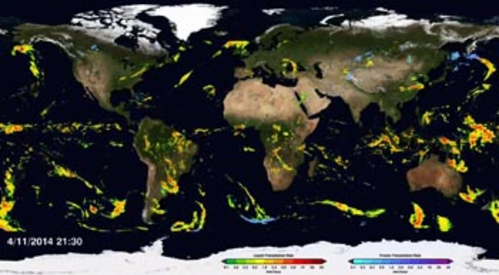
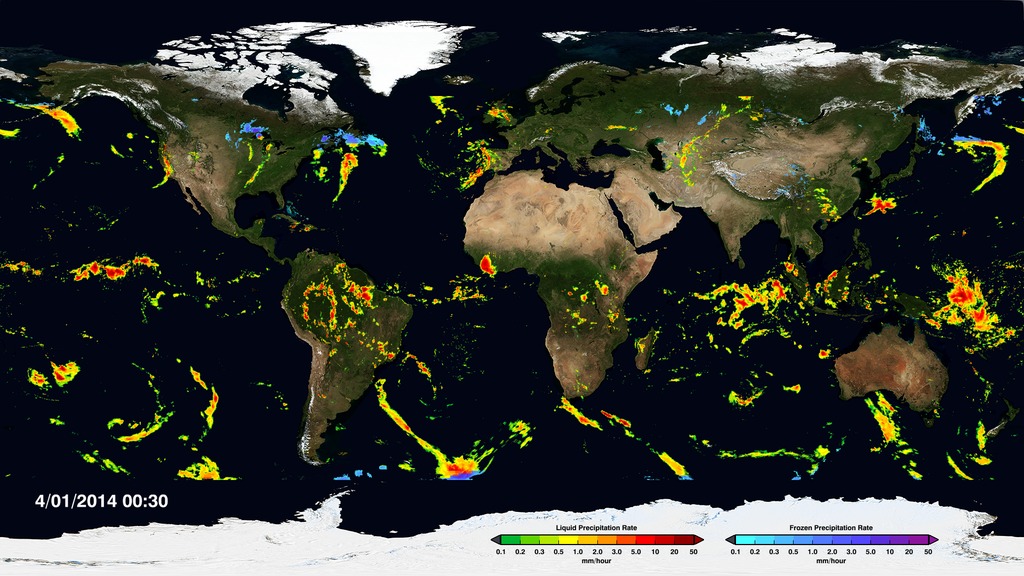
A new data set produced by NASA and the Japan Aerospace Exploration Agency’s Global Precipitation Measurement (GPM) mission is providing scientists with the most complete look at rainfall and snowfall to date. Called IMERG, the data set combines precipitation measurements from 12 Earth-observing satellites and the GPM Core Observatory spacecraft, which launched in February 2014. Maps created from the data set reveal what’s happening beneath Earth’s clouds, allowing researchers to see the movement of rain and snow storms around the planet. Falling rain and snow are essential parts of Earth's water cycle, which governs regional weather systems and the movement of heat energy that helps drive our climate system. The maps will inform climate models that can provide a long-term outlook on how precipitation patterns may change in the future. Watch the video to learn more.
Take a tour of the first precipitation maps created from the IMERG data set in this video.
The IMERG data set covers the 87 percent of the globe that falls between 60 degrees north and 60 degrees south latitude (highlighted above).
The IMERG data set is updated every half hour, allowing scientists to study the evolution of storms as they march eastward across North America.
The high-resolution views provided by IMERG show how storm systems near the equator travel westward from Africa toward South America.
For More Information
See NASA.gov
Credits
Please give credit for this item to:
NASA's Goddard Space Flight Center
-
Producers
- Ryan Fitzgibbons (USRA)
- Rani Gran (NASA/GSFC)
-
Animators
- Horace Mitchell (NASA/GSFC)
-
Alex Kekesi
(Global Science and Technology, Inc.)

-
Scientists
- Gail Skofronick Jackson (NASA/GSFC)
-
George Huffman
(NASA/GSFC)
- Dalia B Kirschbaum (NASA/GSFC)
-
Video editor
- Ryan Fitzgibbons (USRA)
-
Writer
- Ellen T. Gray (ADNET Systems, Inc.)
Related
- ID: 11826
 Produced Video
 - ID: 11784
 Produced Video
 - ID: 4257
 Visualization
Release date
This page was originally published on Thursday, March 19, 2015.
This page was last updated on Wednesday, May 3, 2023 at 1:49 PM EDT.