Parched
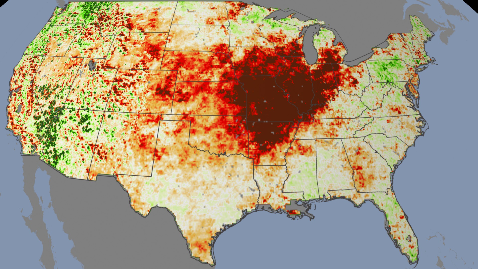
Rain let up and sweltering temperatures descended on the central U.S. in July 2012. On the ground, farmers saw crops wilt. From space, NASA and other satellites saw a pattern of drought spread across multiple states. When plants lack water, the stress ratchets up the temperature of their leaves. Likewise, when soil moisture is plentiful, plant leaves cool down. Instruments on satellites can detect this micro-scale biological response, giving scientists a new way of looking at drought on a large scale. In fact, the satellite instruments are capable of sensing imminent damage before plants themselves begin to wilt, potentially giving farmers an important warning weeks early. The visualization shows changing plant stress conditions across the U.S. from March 2010 to September 2012, including the impact of a 2012 summer heat wave that marked the most severe and extensive drought in the past 25 years.

A new picture of drought reveals the summer of 2012's harsh growing conditions.
The animation is based on a new method, created by U.S. Department of Agriculture scientists, of analyzing NASA and NOAA satellite data.
The end of spring 2010 showed mostly verdant conditions across the country.
By the end of fall 2010, widespread drought plagued the lower Mississippi Valley and the central midwestern states.
Much of the southeastern U.S. had recovered by mid-spring 2011.
Texas and Oklahoma suffered severe drought throughout the summer of 2011.
In the summer of 2012, the center of an even harsher drought shifted back to major crop-producing states of the midwest.
For More Information
See NASA.gov
Credits
Please give credit for this item to:
NASA's Goddard Space Flight Center
-
Animators
-
Helen-Nicole Kostis
(USRA)

- Horace Mitchell (NASA/GSFC)
-
Greg Shirah
(NASA/GSFC)
-
Helen-Nicole Kostis
(USRA)
-
Video editor
- Michael Randazzo (Advocates in Manpower Management, Inc.)
-
Narrator
- Alison Schuyler Ogden (NASA/GSFC)
-
Producers
- Alison Schuyler Ogden (NASA/GSFC)
- Matthew R. Radcliff (USRA)
-
Scientists
- Martha C. Anderson (USDA-ARS-Hydrology and Remote Sensing Laboratory)
- Wayne P. Dulaney (USDA-ARS-Hydrology and Remote Sensing Laboratory)
- Chris Hain (NASA/MSFC)
-
Writer
- Patrick Lynch (Wyle Information Systems)
Related
- ID: 4015
 Visualization
Release date
This page was originally published on Thursday, January 3, 2013.
This page was last updated on Wednesday, May 3, 2023 at 1:52 PM EDT.