MOLA Zooming Down to Reveal a Hidden Channel (Slow)
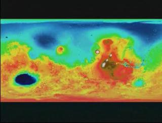
In this visualization, using MOLA data, zooming down to
look at where the hidden channel of water located.

In this image, using MOLA data, we display where
the hidden channel of water is located.
In this image, this is the MOLA data, that is used
to see things like the terrian.
Video slate image reads, "MOLA
Zooming down to reveal a hidden channel".
For More Information
Credits
Please give credit for this item to:
NASA/Goddard Space Flight Center
Scientific Visualization Studio
-
Animator
- Stuart A. Snodgrass (Global Science and Technology, Inc.)
-
Scientist
- David Smith (NASA/GSFC)
Missions
This page is related to the following missions:Series
This page can be found in the following series:Datasets used
-
[MGS: MOLA]
ID: 59
Note: While we identify the data sets used on this page, we do not store any further details, nor the data sets themselves on our site.
Alternate Versions
- ID: 1096
Release date
This page was originally published on Monday, June 19, 2000.
This page was last updated on Wednesday, May 3, 2023 at 1:58 PM EDT.