Perpetual Ocean
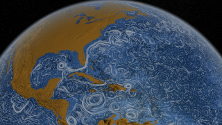
Driven by wind and other forces, currents on the ocean surface cover our planet. Some span hundreds to thousands of miles across vast ocean basins in well-defined flows. Others are confined to particular regions and form slow-moving, circular pools. Seen from space, the circulating waters offer a study in both chaos and order. The visualization below, based on ocean temperature, salinity, sea surface height and sea ice data collected during field observations and by NASA satellites between July 2005 and December 2007, highlights many of the world's most important ocean surface currents. Watch powerful, fast-moving currents like the Gulf Stream in the Atlantic Ocean and the Kuroshio in the Pacific Ocean carry warm waters northeastward at speeds greater than 4 mph. View coastal currents such as the Agulhas in the Southern Hemisphere transporting equatorial waters from the Indian Ocean farther southwards. Explore the image collection to compare the direction and unique flow pattern of each of these major currents.

Watch surface currents circulate in this high-resolution, 3D model of the Earth's oceans.
Distinctive white lines trace the flow of surface currents around the world.
The Gulf Stream carries warm water from the eastern coastline of the United States to regions of the North Atlantic Ocean.
The Agulhas Current travels along the coastline of Mozambique and South Africa and then loops eastward.
The Kuroshio Current flows northeast off the coast of Japan transporting warm ocean water circulating east of Taiwan.
For More Information
See NASA.gov
Credits
Please give credit for this item to:
NASA's Goddard Space Flight Center
-
Animators
-
Greg Shirah
(NASA/GSFC)

- Horace Mitchell (NASA/GSFC)
-
Greg Shirah
(NASA/GSFC)
-
Video editor
- Victoria Weeks (HTSI)
-
Scientists
- Hong Zhang (UCLA)
- Dimitris Menemenlis (NASA/JPL CalTech)
-
Writer
- Kayvon Sharghi (USRA)
Related
- ID: 11015
 Produced Video
 - ID: 3827
 Visualization
Release date
This page was originally published on Thursday, November 10, 2011.
This page was last updated on Wednesday, May 3, 2023 at 1:53 PM EDT.