The Rainmaker
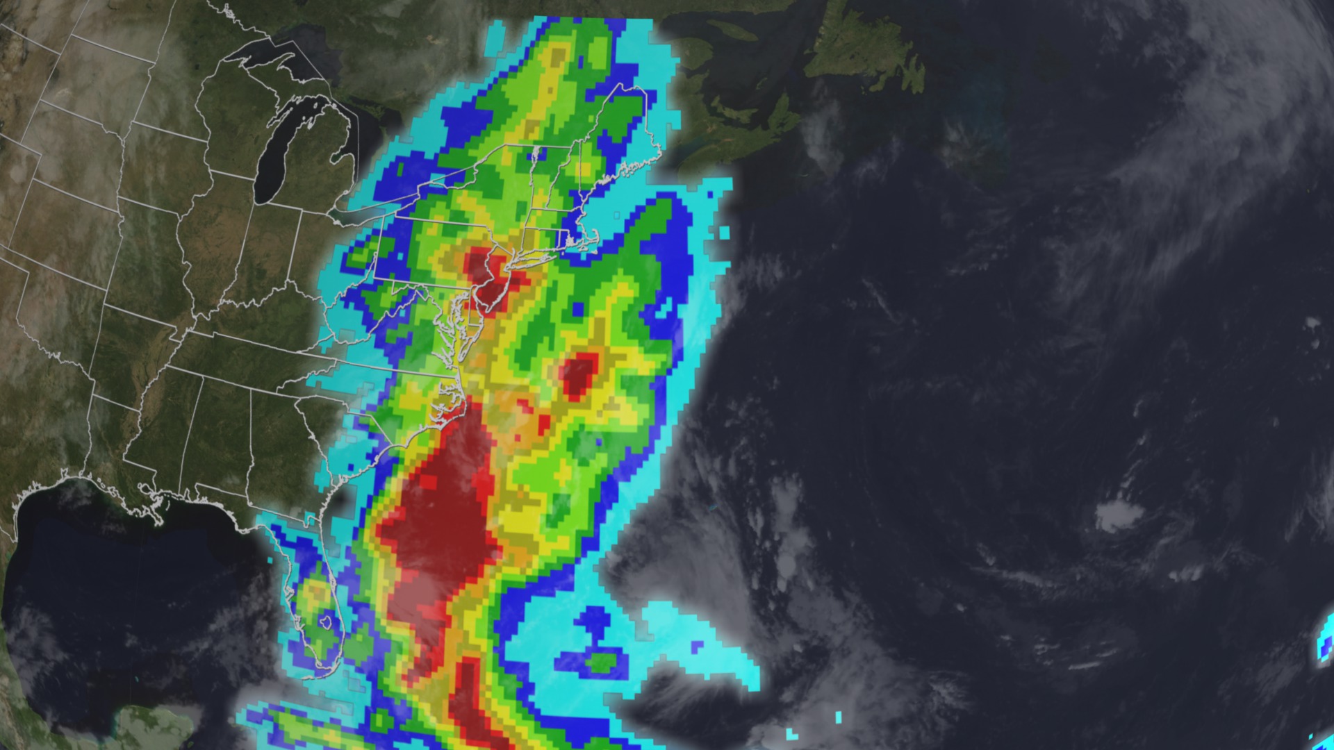
With the peak of the 2011 hurricane season behind us, Irene will likely go down as the biggest rainmaker of the year. The Tropical Rainfall Measuring Mission (TRMM), a joint NASA and JAXA satellite, monitored Irene's rainfall as the storm churned from the Caribbean up the Eastern Seaboard of the United States from August 20 through 29, 2011. Irene's heaviest rainfall totaled over 8.9 inches as its eye reached Cape Lookout, North Carolina. Other rainfall hotspots included New Jersey (upward of 8 inches in some counties), and upstate New York and Vermont, where satellite estimates show rainfall of up to 5.9 inches in some areas. As Irene swept northward, it turned into a depression, dumping heavy, but less damaging rains on parts of Canada before breaking up over the Labrador Sea. In the visualization below, watch Irene whirl its way up the Atlantic coastline.

Rainfall estimates for Hurricane Irene are in. Find out which place got the wettest.
Hurricane Irene's stormy path from Aug. 17 to Aug. 29, viewed from space. Regions of heaviest rainfall are shown in red.
A view of Hurricane Irene's clouds is followed by raw rainfall data from TRMM. The darkest red represents more than 8.75 inches of rain.
Irene's eye settles briefly over Cape Hatteras, North Carolina on August 27, 2011.
Irene's 600-mile-wide cloud cover stretched across one-third of the East Coast of the United States.
Credits
Please give credit for this item to:
NASA's Goddard Space Flight Center Scientific Visualization Studio
-
Animators
-
Greg Shirah
(NASA/GSFC)

- Lori Perkins (NASA/GSFC)
- Trent L. Schindler (USRA)
-
Greg Shirah
(NASA/GSFC)
-
Producer
- Matthew R. Radcliff (USRA)
-
Scientists
- Arthur Hou (NASA/GSFC)
- Chris Kidd (University of Maryland)
-
Writer
- Alison Schuyler Ogden (NASA/GSFC)
Related
- ID: 3852
 Visualization
Release date
This page was originally published on Tuesday, October 4, 2011.
This page was last updated on Wednesday, May 3, 2023 at 1:53 PM EDT.