Earth
ID: 4316
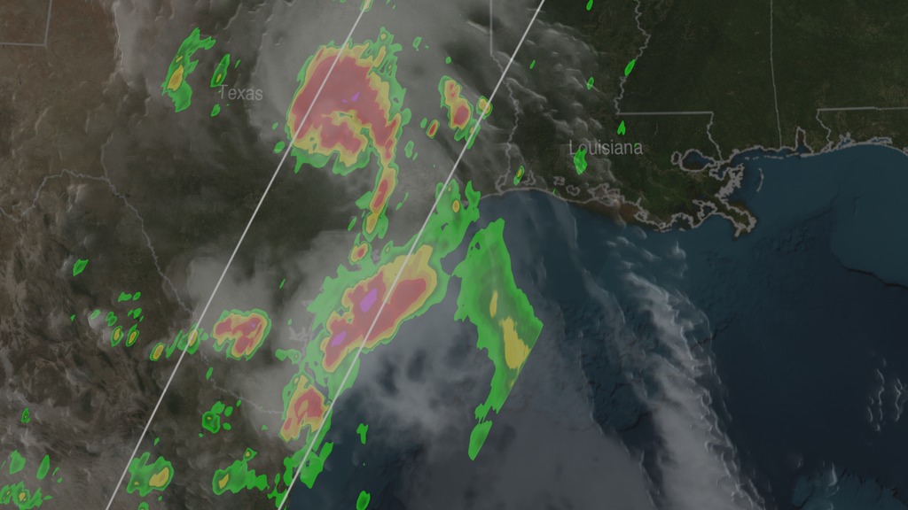
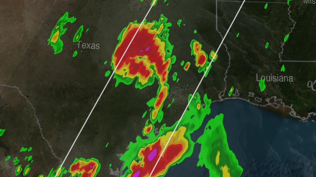
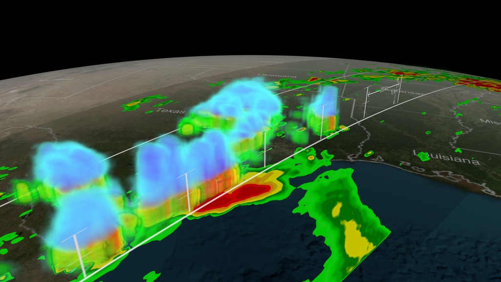
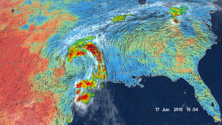
Tropical Storm Bill made landfall over Texas at approximately 11:45am CST on June 16, 2015. Shortly after midnight, GPM passed over the storm as it slowly worked it's way northward across the already drenched state of Texas. This visualization shows Bill at precisely 12:11:27am CST (6:11:27 GMT) on June 17, 2015.
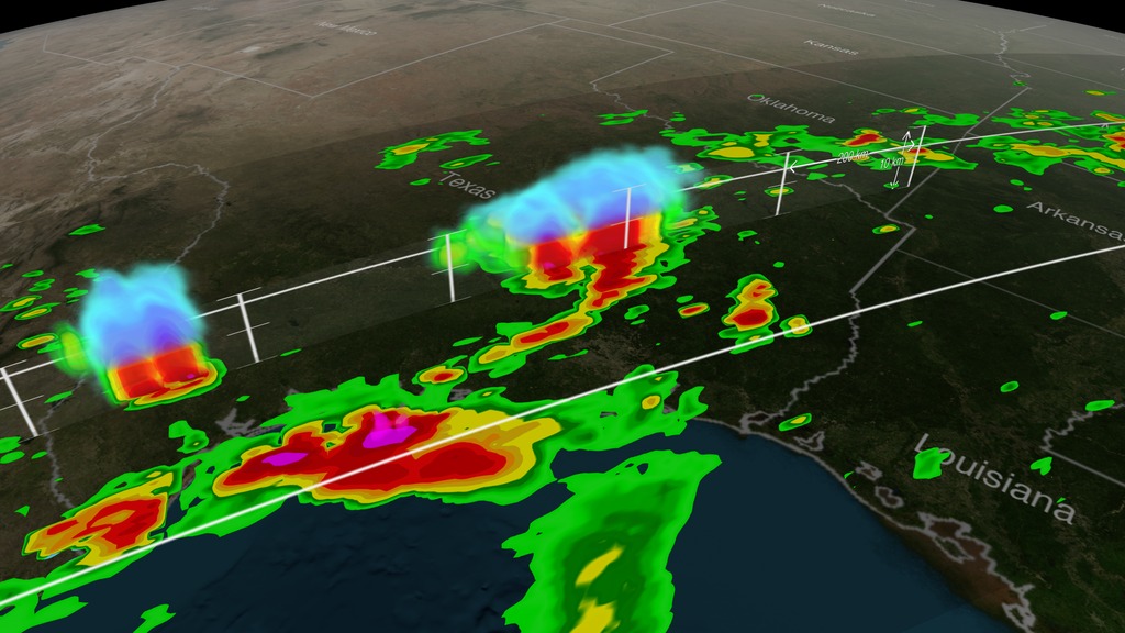
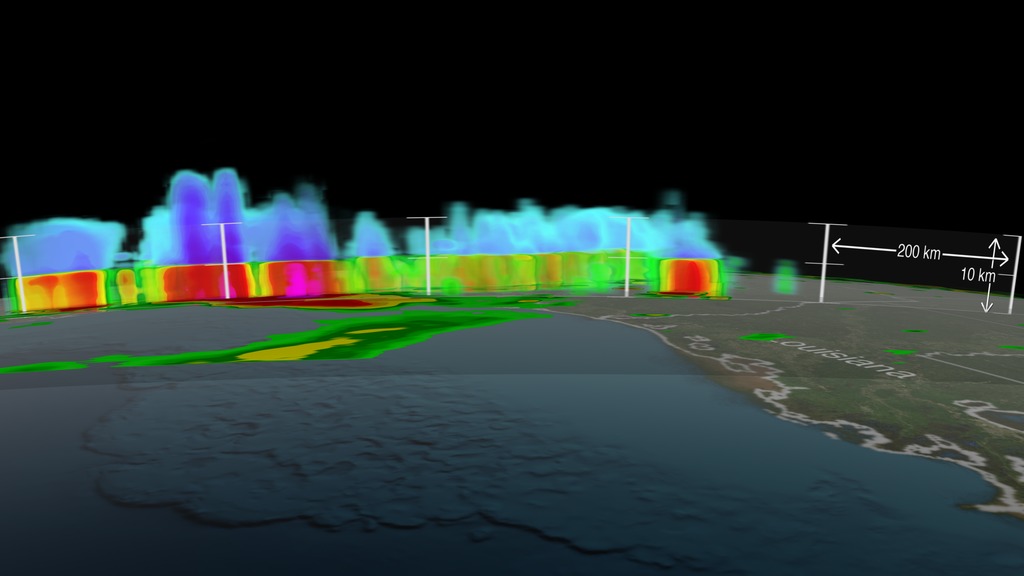
The GPM Core Observatory carries two instruments that show the location and intensity of rain and snow, which defines a crucial part of the storm structure – and how it will behave. The GPM Microwave Imager sees through the tops of clouds to observe how much and where precipitation occurs. The Dual-frequency Precipitation Radar provides the three-dimensional view, showing the structure of the storm spiraling inward toward the center, with heavier rain on the north side of the storm. Shades of blue represent ice in the upper part of clouds. Viewed from the side, the stark color change from blue to green marks the transition from ice to rain.
For forecasters, GPM's microwave and radar data are part of the toolbox of satellite data, including other low Earth orbit and geostationary satellites, that they use to monitor tropical cyclones and hurricanes.
The addition of GPM data to the current suite of satellite data is timely. Its predecessor precipitation satellite, the Tropical Rainfall Measuring Mission, after 18 years of operation was deorbited June 16 (the same day Tropical Storm Bill made landfall). GPM's new high-resolution microwave imager data and the unique radar data ensure that forecasters and modelers won't have a gap in coverage. GPM is a joint mission between NASA and the Japan Aerospace Exploration Agency. All GPM data products can be found at NASA Goddard's Precipitation Processing Center.


Tropical Storm Bill Over Texas
The GPM Core Observatory carries two instruments that show the location and intensity of rain and snow, which defines a crucial part of the storm structure – and how it will behave. The GPM Microwave Imager sees through the tops of clouds to observe how much and where precipitation occurs. The Dual-frequency Precipitation Radar provides the three-dimensional view, showing the structure of the storm spiraling inward toward the center, with heavier rain on the north side of the storm. Shades of blue represent ice in the upper part of clouds. Viewed from the side, the stark color change from blue to green marks the transition from ice to rain.
For forecasters, GPM's microwave and radar data are part of the toolbox of satellite data, including other low Earth orbit and geostationary satellites, that they use to monitor tropical cyclones and hurricanes.
The addition of GPM data to the current suite of satellite data is timely. Its predecessor precipitation satellite, the Tropical Rainfall Measuring Mission, after 18 years of operation was deorbited June 16 (the same day Tropical Storm Bill made landfall). GPM's new high-resolution microwave imager data and the unique radar data ensure that forecasters and modelers won't have a gap in coverage. GPM is a joint mission between NASA and the Japan Aerospace Exploration Agency. All GPM data products can be found at NASA Goddard's Precipitation Processing Center.
Related

Visualization Credits
Alex Kekesi (Global Science and Technology, Inc.): Lead Visualizer
Greg Shirah (NASA/GSFC): Visualizer
Gail Skofronick Jackson (NASA/GSFC): Lead Scientist
George Huffman (NASA/GSFC): Lead Scientist
Dalia B Kirschbaum (NASA/GSFC): Lead Scientist
Rani Gran (NASA/GSFC): Lead Producer
Ryan Fitzgibbons (USRA): Producer
Eric Sokolowsky (Global Science and Technology, Inc.): Project Support
Please give credit for this item to:
NASA's Scientific Visualization Studio
NASA's Scientific Visualization Studio
Short URL to share this page:
https://svs.gsfc.nasa.gov/4316
Missions:
Global Precipitation Measurement (GPM)
LDCM: Landsat Data Continuity Mission
Data Used:
Note: While we identify the data sets used in these visualizations, we do not store any further details nor the data sets themselves on our site.
This item is part of this series:
GPM Animations
Keywords:
DLESE >> Atmospheric science
SVS >> HDTV
SVS >> Tropical Storm
GCMD >> Earth Science >> Atmosphere >> Precipitation >> Rain
SVS >> Hyperwall
NASA Science >> Earth
SVS >> Presentation
GCMD >> Earth Science >> Human Dimensions >> Natural Hazards >> Floods
GCMD keywords can be found on the Internet with the following citation: Olsen, L.M., G. Major, K. Shein, J. Scialdone, S. Ritz, T. Stevens, M. Morahan, A. Aleman, R. Vogel, S. Leicester, H. Weir, M. Meaux, S. Grebas, C.Solomon, M. Holland, T. Northcutt, R. A. Restrepo, R. Bilodeau, 2013. NASA/Global Change Master Directory (GCMD) Earth Science Keywords. Version 8.0.0.0.0
https://svs.gsfc.nasa.gov/4316
Missions:
Global Precipitation Measurement (GPM)
LDCM: Landsat Data Continuity Mission
Data Used:
GPM/GMI/Surface Precipitation also referred to as: Rain Rates
6/17/2015 6:11:27Z
Credit:
Data provided by the joint NASA/JAXA GPM mission.
Data provided by the joint NASA/JAXA GPM mission.
GPM/DPR/Ku also referred to as: Volumetric Precipitation data
Observed Data - JAXA - 6/17/2015 6:11:27Z
Credit:
Data provided by the joint NASA/JAXA GPM mission.
Data provided by the joint NASA/JAXA GPM mission.
This item is part of this series:
GPM Animations
Keywords:
DLESE >> Atmospheric science
SVS >> HDTV
SVS >> Tropical Storm
GCMD >> Earth Science >> Atmosphere >> Precipitation >> Rain
SVS >> Hyperwall
NASA Science >> Earth
SVS >> Presentation
GCMD >> Earth Science >> Human Dimensions >> Natural Hazards >> Floods
GCMD keywords can be found on the Internet with the following citation: Olsen, L.M., G. Major, K. Shein, J. Scialdone, S. Ritz, T. Stevens, M. Morahan, A. Aleman, R. Vogel, S. Leicester, H. Weir, M. Meaux, S. Grebas, C.Solomon, M. Holland, T. Northcutt, R. A. Restrepo, R. Bilodeau, 2013. NASA/Global Change Master Directory (GCMD) Earth Science Keywords. Version 8.0.0.0.0


