Calving of A-68 from the Larsen C Ice Shelf, Antarctica 2016-2017

Developing rift
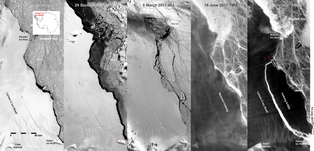
These images show composite images from Landsat 8’s Operational Land Imager (OLI) over Antarctica’s 4th largest ice shelf, the ~40,000 km2 (15,400 mi2) Larsen C Ice Shelf as the rift that released Iceberg A-68 evolved until July 2017. During the austral winter of 2017’s polar darkness, Landsat 8’s Thermal Infrared Sensor (TIRS) imagery was merged with contemporaneous Visible Infrared Imaging Radiometer Suite (VIIRS) imagery from the Suomi National Polar-Orbiting Partnership (Suomi NPP) satellite to show the rift or the ~5800 km2 (2240 mi2) iceberg. Once sunlight returned to this part of the Antarctic Peninsula, Moderate Resolution Imaging Spectroradiometer (MODIS) from the Terra or Aqua satellites completed composite views of the iceberg’s motion. The date on each slide is for the Landsat scenes covering the ice shelf front and majority of the iceberg.
In the first image, the advancing rift tip’s position is indicated by the northern red arrow relative to the one just north of Gipps Ice Rise, a bedrock knob above sea level. The completion of the rift was captured on July 11 by VIIRS thermal imagery and is shown on July 12th. The brighter, whiter, warmer ocean water in the rift contrasts strongly with the darker, colder ice shelf or iceberg surface in the TIRS/VIIRS composite image. Due to a strong storm in the Weddell Sea at the time of the calving, the >1 trillion ton iceberg’s motion led to a collision that produced the smaller A-68B iceberg by July 14 th at the northern end of A-68. Although this large calving event is not itself evidence of climate change in this part of the Antarctic Peninsula, an even larger iceberg was calved in 1986, it does mean that the Larsen C’s ice shelf’s front is now as far landward as it has ever been in the history of human observations in this area.
Credit: Christopher A. Shuman, University of Maryland, Baltimore County,
at NASA Goddard Space Flight Center’s Cryospheric Sciences Laboratory, Greenbelt, MD USA
Completion of the rift
Motion of Iceberg A-68 following rift
Comparison before and after the rift
For More Information
Credits
Please give credit for this item to:
NASA's Goddard Space Flight Center
-
Animator
- Amy Moran (Global Science and Technology, Inc.)
-
Scientist
- Christopher Shuman (UMBC JCET)
Release date
This page was originally published on Thursday, December 7, 2017.
This page was last updated on Sunday, December 15, 2024 at 12:26 AM EST.
Datasets used
-
[Landsat]
ID: 47 -
VIIRS [Suomi NPP: VIIRS]
ID: 722 -
[Landsat-8: TIRS]
ID: 790
Note: While we identify the data sets used on this page, we do not store any further details, nor the data sets themselves on our site.
Related
- ID: 30890