https://eol.jsc.nasa.gov/DatabaseImages/EO/highres/ISS030/ISS030-E-12516.JPG, EO/highres/ISS030, ISS030-E-12516.JPG, MAURITANIA, Richat Structure
The Richat Structure of Mauritania has captured the attention of astronauts for about as long as NASA has sent humans into orbit around Earth. This circular geologic feature is thought to be caused by an uplifted dome geologists would classify it as a domed anticline that has been eroded to expose the originally flat rock layers.
In this type of geologic structure, rocks exposed in the center of the bulls-eye are older than rocks forming the outer rings. This structure measures 45 kilometers (28 miles) across and is made up of igneous and sedimentary rocks. There are several faults visible (lower left) where strata that were once continuous have been shifted apart.
Most of Mauritania lies within the Sahara Desert, where dry climate conditions and periodic droughts create difficult living conditions. Approximately 3.7 million people live in Mauritania, though much of the population lives along its Atlantic coastline, about 500 kilometers (300 miles) from the Richat Structure.
https://eol.jsc.nasa.gov/DatabaseImages/EFS/highres/ISS030/ISS030-E-55569.JPG, EFS/highres/ISS030, ISS030-E-55569.JPG, USA-GEORGIA, Southeastern USA at Night
The southern United States is known for its distinctive cultural and historical identify within the country--this distinctiveness includes music, cuisine, literature, and social customs. The US Census Bureau defines "The South" to include the states of Alabama, Arkansas, Delaware, Florida, Georgia, Kentucky, Louisiana, Maryland, Mississippi, North Carolina, Oklahoma, South Carolina, Tennessee, Texas, Virginia, and West Virginia. This astronaut photograph from the International Space Station highlights the southeastern part of the South at night, including the eastern Gulf of Mexico and lower Atlantic Seaboard states.
Following the American Civil War (1861-1865), the southern USA continued to be mostly agrarian until the latter half of the 20th century, when increased migration from other areas of the country (and immigration from outside the USA) led to increased urbanization. The brightly lit metropolitan areas of Atlanta, GA (image center) and Jacksonville, FL (image lower right) appear largest in the image with numerous other urban areas forming an interconnected network of light across the region. A large dark region to the northwest of Jacksonville, FL is the Okefenokee National Wildlife Refuge; likewise the ridges of the Appalachian mountains form dark swaths to the north of Atlanta, GA and west of Charlotte, NC (image center). The faint gold and green line of airglow--caused by ultraviolet radiation exciting the gas molecules in the upper atmosphere--parallels the horizon (or Earth limb).
https://eol.jsc.nasa.gov/DatabaseImages/ESC/large/ISS030/ISS030-E-55569.JPG, ESC/large/ISS030, ISS030-E-55569.JPG, USA-GEORGIA, Southeastern USA at Night
The southern United States is known for its distinctive cultural and historical identify within the country--this distinctiveness includes music, cuisine, literature, and social customs. The US Census Bureau defines "The South" to include the states of Alabama, Arkansas, Delaware, Florida, Georgia, Kentucky, Louisiana, Maryland, Mississippi, North Carolina, Oklahoma, South Carolina, Tennessee, Texas, Virginia, and West Virginia. This astronaut photograph from the International Space Station highlights the southeastern part of the South at night, including the eastern Gulf of Mexico and lower Atlantic Seaboard states.
Following the American Civil War (1861-1865), the southern USA continued to be mostly agrarian until the latter half of the 20th century, when increased migration from other areas of the country (and immigration from outside the USA) led to increased urbanization. The brightly lit metropolitan areas of Atlanta, GA (image center) and Jacksonville, FL (image lower right) appear largest in the image with numerous other urban areas forming an interconnected network of light across the region. A large dark region to the northwest of Jacksonville, FL is the Okefenokee National Wildlife Refuge; likewise the ridges of the Appalachian mountains form dark swaths to the north of Atlanta, GA and west of Charlotte, NC (image center). The faint gold and green line of airglow--caused by ultraviolet radiation exciting the gas molecules in the upper atmosphere--parallels the horizon (or Earth limb).
https://eol.jsc.nasa.gov/DatabaseImages/EO/highres/ISS030/ISS030-E-91253.JPG, EO/highres/ISS030, ISS030-E-91253.JPG, ARGENTINA, Perito Moreno Glacier, Lake Argentino, Argentina
The largest glacier tongue in this image is known as the Perito Moreno Glacier (image center). It descends from the Southern Patagonian Icefield (image top) at great altitudes (>2100 m, 6825 feet) in the southern Andes Mts., down into the water and warmer altitudes of Lake Argentino at ~180 m above sea level. The glacier is 30 km long (image width represents ~60 km on the ground).
Perito Moreno is one of the largest glaciers in Patagonia, and is perhaps the most famous for the fact that it periodically cuts off the major southern arm (known as Brazo Rico) of Lake Argentino completely from the rest of the lake. This is because the glacier advances right across the lake until it meets the opposite shoreline. The ice tongue is "grounded" (meaning that it is not floating, as occurs at the termini of glaciers and ice shelves where they enter the sea), thus forming a natural dam which prevents the lake water on either side from circulating, which in turn causes muddier, "milkier" water to concentrate in Brazo Rico. Sub-ice water, now expected to be more active with global warming, flows under the ice, not only carrying the mud into the lake but also helping lubricate the glacier's downhill movement.
Because of its effect as a dam, meltwater from the south raises water levels in Brazo Rico by as much as 30 m above the level of the water in L. Argentino. The great pressure of this higher water ultimately causes the ice tongue to rupture catastrophically, in a great natural spectacle. The last rupture took place in March 2012. The process then repeats, on average every 4-5 years, as the glacier starts to grow back towards the opposite shoreline. The repeatability of the rupture has contributed to the event becoming a major tourist attraction in the region.
https://eol.jsc.nasa.gov/DatabaseImages/EO/highres/ISS030/ISS030-E-110900.JPG, EO/highres/ISS030, ISS030-E-110900.JPG, CANADA-Q, Aurora and Manicouagan Crater, Quebec, at night
An astronaut aboard the International Space Station adjusted the camera for night imaging--and captured green veils and curtains of an aurora that spans thousands of km of Canada's northern lands. Snow and ice in this winter image reflect enough light from stars and the aurora to reveal several details of the night landscape--especially ice on the frozen reservoir that now occupies the 60-km Manicouagan impact crater (at image lower right). Another ice-covered, irregularly shaped reservoir--Caniapiscau--is more difficult to detect (at image left). City lights reveal the small towns of the region, like the iron-ore mining town of Labrador City (at image center right) and the Royal Canadian Air Force (RCAF) base Goose Bay (at image top right).
The brilliant aurora borealis is the light that glows when charged particles from the Sun collide with atoms in the atmosphere. The green and faint red colors are caused by oxygen atoms. The fainter arc of light that parallels the horizon is known as airglow. This is another, but different manifestation of the interaction of the Earth's atmosphere with radiation from the Sun.
The atmosphere shields living things on Earth's surface from the Sun's harmful radiation. It also causes small impacting asteroids to burn up in the atmosphere, or catastrophically explode like the Chelyabinsk event of 2013, before hitting the ground.
By contrast, larger asteroids are able to penetrate the atmosphere and collide with our rocky planet, with dramatic effects. Geologists now know that a large asteroid slammed into the Earth about 214 million years ago, creating a crater ~100 km across (60 miles), although the Manicouagan crater in its present form, after erosion by "recent" glaciers in the last 2 million years, is today ~60 km (37 miles) wide. The impact caused a shock wave to radiate across the Earth's surface, followed closely by high-velocity winds. Near the impact point wind speeds would have exceeded 1000 km per hour (620 miles per hour). Farther away winds would have decelerated to hurricane force. The shock wave and airblast would have severely damaged and killed plants and animals out to radial distances of approximately 560 km (350 miles)--as far as the town of Goose Bay on the Labrador Sea (at image top right)--that is, the lower half of this scene.
https://eol.jsc.nasa.gov/DatabaseImages/EO/highres/ISS031/ISS031-E-146306.JPG, EO/highres/ISS031, ISS031-E-146306.JPG, USA-WYOMING, ISS031-E-146306 (27 June 2012) --- An Expedition 31 crew member aboard the International Space Station, flying approximately 240 miles (386 kilometers) above Earth, captured this view of the Fontenelle fire on June 27, 2012. The fire, burning in Wyoming 18 miles (29 kilometers) west of Big Piney, was discovered on June 24. [Editor's update --- By the morning of June 28, the fire had burned 25,000 acres (101 square kilometers). By July 6, the area burned had more than doubled to 57,324 acres (232 square kilometers), and the fire was 25 percent contained].
https://eol.jsc.nasa.gov/DatabaseImages/EO/highres/ISS031/ISS031-E-148455.JPG, EO/highres/ISS031, ISS031-E-148455.JPG, EGYPT, Toshka Lakes 2002-2012, southern Egypt
The Toshka Lakes were formed in the Sahara Desert of Egypt by water from the River Nile conveyed from Lake Nasser by a canal to the Toshka Depression. Flooding of the Toshka Depression had created the four main lakes with a maximum surface area in 2002 of ~1450 km2 -- around 25.26 billion cubic meters of water. By 2006 the stored water was reduced by 50% and by 2012, this image shows open water only in the lowest parts of the main western and eastern basins--representing a reduction in surface area to 307 km2--nearly 80% smaller than the 2002 surface area. Standing water is almost completely absent from the central basin.
From space, astronauts documented the first lake--the easternmost one--in 1998. The lakes progressively grew in depressions to the west, the westernmost filling between 2000 and 2001. The image shows lines of center-point agricultural fields near the east-basin lake (dark dots at image center) nearest Lake Nasser. Sunglint on the western lake makes the water surface appear both light and dark, depending on which parts of the surface were ruffled by the wind at the moment the image was taken.
https://eol.jsc.nasa.gov/DatabaseImages/EO/highres/ISS031/ISS031-E-148455_2.JPG, EO/highres/ISS031, ISS031-E-148455_2.JPG, EGYPT, Toshka Lakes 2002-2012, southern Egypt
The Toshka Lakes were formed in the Sahara Desert of Egypt by water from the River Nile conveyed from Lake Nasser by a canal to the Toshka Depression. Flooding of the Toshka Depression had created the four main lakes with a maximum surface area in 2002 of ~1450 km2 -- around 25.26 billion cubic meters of water. By 2006 the stored water was reduced by 50% and by 2012, this image shows open water only in the lowest parts of the main western and eastern basins--representing a reduction in surface area to 307 km2--nearly 80% smaller than the 2002 surface area. Standing water is almost completely absent from the central basin.
From space, astronauts documented the first lake--the easternmost one--in 1998. The lakes progressively grew in depressions to the west, the westernmost filling between 2000 and 2001. The image shows lines of center-point agricultural fields near the east-basin lake (dark dots at image center) nearest Lake Nasser. Sunglint on the western lake makes the water surface appear both light and dark, depending on which parts of the surface were ruffled by the wind at the moment the image was taken.
https://eol.jsc.nasa.gov/DatabaseImages/EO/highres/ISS032/ISS032-E-8976.JPG, EO/highres/ISS032, ISS032-E-8976.JPG, DOMINICAN REPUBLIC, Saharan Dust Reaches the Americas
Weather satellites frequently document major dust palls blowing from the Sahara Desert westward from Africa out into the tropical Atlantic Ocean. Astronauts frequently see these Saharan dust masses as very widespread atmospheric haze. Dust palls blowing from Africa can be transported right across the Atlantic Ocean. It takes about a week to reach either North America (in northern hemisphere summer) or South America (in northern hemisphere winter). This puts the Caribbean basin on the receiving end of many of these events. Recently, researchers have linked Saharan dust to coral disease, allergic reactions in humans, and red tides.
The margin of the hazy air in this image, taken recently by astronauts on board the International Space Station (ISS), reaches as far as Haiti (image center) and the nearby Turks and Caicos Islands (image left) - but the eastern tip of Cuba in the foreground remains in the clear air. This image attracted the eye of scientists at the Johnson Space Center because the margin between the dust haze and the clear atmosphere lies in almost the same location as it appears in another astronaut image, also taken in mid-July, but nearly twenty years ago (in 1994) by astronauts aboard the Space Shuttle Columbia. In 1994, few scientists had considered the possibility of transatlantic dust transport.
It may be surprising that the dust is still visible in the downwind hemisphere thousands of kilometers from its origin, here probably almost 8000 km from its likely source in northern Mali--although data from sensors such as NASA's TOMS (Total Ozone Mapping Spectrometer) and OMI (Ozone Monitoring Instrument) have suggested that some dust transported across the Atlantic may have originated further east in Chad or Sudan. We now know that African dust reaches the western hemisphere every month of the year, not necessarily in as highly a visible form as in these images. Also, there is evidence that some of this African dust even serves as a source of airborne nutrients for Amazon rainforest vegetation. Saharan dust is known on occasion to reach all the way into the Pacific Ocean, crossing Mexico at the narrow Isthmus of Tehuantepec.
https://eol.jsc.nasa.gov/DatabaseImages/EO/highres/ISS032/ISS032-E-9123.JPG, EO/highres/ISS032, ISS032-E-9123.JPG, EGYPT, Pyramids at Giza, Egypt
Note: This caption refers to the image versions labeled "NASA's Earth Observatory web site".
The Great Pyramids at Giza (image center) are the last of the Seven Wonders of the Ancient World, and are perhaps the most famous of the ancient monuments in the Nile River Delta region of Egypt. They are also a favorite subject of photography from orbit - particularly when high resolution imagery can be obtained. This subset of a larger astronaut photograph illustrates the degree of detail visible from the International Space Station using a long focal length lens to provide high magnification of the land surface. With good sun illumination of the scene and a steady hand on the camera to track the feature of interest, current off-the-shelf digital cameras on board the ISS can obtain detailed imagery to rival that of automated satellite sensor systems in orbit.
The southeast-facing sides of the pyramids of the pharaohs Khufu, Khafre, and Menkaure are all brightly illuminated by the sun, while the northwest facing sides are in shadow. This shadowing also highlights smaller unfinished pyramids to the south of Menkaure's pyramid, as well as fields of rectangular flat roofed mastabas (tombs) to the east and west of Khufu's pyramid. While not as grand as the pyramids, mastabas were the burial places of prominent persons during the periods of the ancient pharaohs. To the southeast of Khufu's pyramid, the head and rear haunches of the Sphinx are also visible (albeit not clearly).
It is a short distance between the glories of ancient Egypt and the modern Cairo metropolitan area to the north and east. The green vegetation of a hotel golf course (image right), and the numerous building and streets of El Giza, provide stark contrast to the bare rock and soil of the adjacent desert. Roadways visible in the desert (image left) connect the urban regions to the east with further development to the north (not shown).
https://eol.jsc.nasa.gov/DatabaseImages/EO/highres/ISS032/ISS032-E-10482.JPG, EO/highres/ISS032, ISS032-E-10482.JPG, USA-CALIFORNIA, Sutter Buttes, California
Note: This caption refers to the image versions labeled "NASA's Earth Observatory web site".
Sometimes called the "smallest mountain range in the world", the Sutter Buttes rise almost 610 meters above the surrounding flat agricultural fields of the Great Valley of central California. The Sutter Buttes are remnants of a volcano that was active approximately 1.6 - 1.4 million years ago during the Pleistocene Epoch. The central core of the Buttes is characterized by lava domes -piles of viscous lava that erupted onto the surface, building higher with each successive layer. Today, these lava domes form the high central hills of the Buttes; shadows cast by the hills are visible at image center.
Surrounding the central core is an apron of fragmental material created by occasional eruptions of the lava domes - this apron extends roughly 18 km east-west and 16 km north-south. The volcanic material was transported outwards from the central core during eruptions by hot gasses (pyroclastic flows) or by cooler water-driven flows (lahars). Later stream erosion of the debris apron is evident from the radial drainage pattern surrounding the central core. A third geomorphic region of valleys known as the "moat" is present between the core and the debris apron, and was formed from erosion of older, exposed sedimentary rocks that underlie the volcanic rocks.
The Sutter Buttes present a striking visual contrast with the surrounding green agricultural fields--here mostly rice, with some sunflower, winter wheat, tomato, and almonds--of the Great Valley. Urban areas such as Yuba City, CA (located 18 km to the southeast) appear as light to dark gray stippled regions. Sacramento, CA (not shown) is located approximately 80 km to the south-southeast. The image appears slightly distorted (oblique) due to the viewing angle from the International Space Station.
https://eol.jsc.nasa.gov/DatabaseImages/EO/highres/ISS032/ISS032-E-10487.JPG, EO/highres/ISS032, ISS032-E-10487.JPG, USA-NEVADA, Walker Lake, Nevada
Note: This caption refers to the image versions labeled "NASA's Earth Observatory web site".
The Pleistocene landscape of western Nevada approximately 15,000 years ago was one of narrow mountain ranges and numerous interconnected lakes that together formed the extensive glacial Lake Lahontan. Drying and warming of the regional climate since the last Ice Age led to the disappearance of the glaciers feeding meltwater to Lake Lahontan, and eventual disappearance of the lake itself. Today, few remnants of Lahontan remain; most of its arms have become dry enclosed basins known as playas.
This astronaut photograph highlights Walker Lake, one of only two remnant lakes that contain water throughout the year (Pyramid Lake in Nevada is the other). Walker Lake is located in an enclosed basin bounded by the Wassuk Range to the west and the Gillis Range to the east. The lake is fed by the Walker River flowing from the north. The current dimensions of the lake are approximately 21 kilometers north-south by 9 km east-west. Shoreline deposits at higher elevations than the current lake level form concentric bands that are just visible in the image (top center) - these record varying lake levels in the geologic past.
The nearest town to Walker Lake is Hawthorne, Nevada to the southeast. To the southwest the highest peak of the Wassuk Range, Mount Grant (elevation 3496 meters above sea level), dominates the skyline. Green agricultural fields, primarily alfalfa, located to the west of the Wassuk Range (image upper left) provide a striking contrast to the surrounding Great Basin desert. These fields are irrigated using water from the nearby East Fork of the Walker River (image left, just visible alongside the fields).
https://eol.jsc.nasa.gov/DatabaseImages/EO/highres/ISS032/ISS032-E-17547.JPG, EO/highres/ISS032, ISS032-E-17547.JPG, TURKEY, Istanbul, Turkey at Night
Most of Istanbul's Asian suburbs (image right) appear in this night view from the International Space Station, but only about half the area of the city on the European side (image left) can be seen. The margins of the metropolitan area are clearly visible at night, more so than in daylight images. The Bosporus strait (also spelled Bosphorus) (image center left) famously separates the two halves of the city, and links the small Sea of Marmara (and the Mediterranean Sea to its south) to the Black Sea (indistinguishable in this night view, top right). The strait is 31 km long, most of which is visible in this view. The Bosporus is a very busy waterway, with larger ships passing to and from the Black Sea competing with numerous ferries that cross between the two halves of the city.
Apart from the dark Sea of Marmara (lower margin of the image), the other large dark areas are all wooded hills which provide open spaces for the densely populated city of Istanbul - one of the largest in Europe with 13.5 million inhabitants. The old city occupies the prominent point at the entrance to the strait. Major traffic arteries are the brighter lines crossing the metropolitan area, and also mark all the shorelines. The First Bosporus Bridge and Second Bridge (also known as the Fatih Sultan Mehmet Bridge) can be seen spanning the strait. The brilliant lights of both international airports serving the region also stand out at image lower left and image lower right.
https://eol.jsc.nasa.gov/DatabaseImages/EO/highres/ISS032/ISS032-E-17635.JPG, EO/highres/ISS032, ISS032-E-17635.JPG, KUWAIT, Kuwait City at Night
Seen at night Kuwait City, the capital of the small Persian Gulf state of Kuwait, contrasts dramatically with the dark surface of the Persian Gulf (image top) and the very sparsely populated desert area (image bottom). Night views also show at a glance some aspects of urban geography that are difficult to perceive in daylight images. Here the focus of radial traffic arteries and "ring roads" guide the eye to the financial center of the city--on the cape extending into Kuwait Bay north of the First Ring Road. The numbering of the ring roads shows the progressive southward development of the city, towards the Seventh Ring Road which still lies outside the built-up area at image lower right.
The striking differences in color of city lighting also provide information on the urban geography. Areas with lighting of a green tinge are, in each case, newer residential districts. The town of Al Ahmadi (image lower right), known for its verdant vegetation, was built in 1946 when oil was struck and stands out with its characteristic blue night lights. Kuwait International Airport, like most major airports around the globe, is particularly bright due to the high concentration of lights. By contrast, the low residential density of the Emir's palace grounds (which also host the Kuwaiti government offices and a large mosque) stand out as a dark area within the city. The long dark zone facing the Persian Gulf coast, just inshore of a narrow zone of coastal villas (image right), is presently being prepared for residential construction.
https://eol.jsc.nasa.gov/DatabaseImages/EO/highres/ISS032/ISS032-E-24687.JPG, EO/highres/ISS032, ISS032-E-24687.JPG, USA-IDAHO, Idaho Fires, September 2012
Taken with a short lens (45 mm), this west-looking astronaut photograph has a field of view covering much of the forested region of central Idaho. The dark areas are all wooded mountains--the Salmon River Mts. (image left), Bitterroot Mts. (image lower right) and Clearwater Mts. (image right). All three areas experienced wildfires in September 2012--this image illustrates the situation early in the month. Smaller fire 'complexes" appear as tendrils of smoke near the sources (e.g. Halstead complex image left), and as major white smoke plumes from the Mustang fire complex in the densest forests (darkest green, image center) of the Clearwater Mts. This was the largest plume noted in the region with thick smoke blowing eastward over the Beaverhead Mts at image bottom.
The linear shape of the smoke plumes gives a sense of the generally eastward smoke transport on this day in early September. The smoke distribution shows another kind of transport: at night, when winds are weak, cooling of the atmosphere near the ground causes drainage of cooled (denser) air down into the major valleys. Here the smoke can be seen flowing west down into the narrow Salmon and Lochsa River valleys (at a local time of 12:18:50 PM)--in the opposite direction to the higher winds and the thick smoke masses.
The bright yellow-tan areas at image top left and top right contrasting with the mountains are grasslands of the Snake River in southern Idaho around Boise, and the Palouse region in western Idaho-SE Washington state. This latter area is known to ecologists as the Palouse Grasslands Ecoregion. Light green areas visible in the center of many of the valleys are agricultural crops including barley, alfalfa, and wheat.
The image also shows several firsts of which Idaho can boast. The Snake River between Boise and the Palouse region has cut Hells Canyon (image top), the deepest gorge in the US at almost 2436 meters (8000 feet). The largest single wilderness area in the contiguous US, the Frank Church-River of No Return Wilderness occupies the wooded zones of the Salmon River Mts and the Clearwater Mts., i.e. most of the area shown in the middle of the image. Idaho's highest peak is Borah Peak (image lower left) at 3860 meters above sea level (12,662 feet asl). The Continental Divide cuts through the bottom of the image--rivers on the eastern slopes of the Beaverhead Mts drain to the Atlantic Ocean, whereas rivers in the rest of the area drain to the Pacific Ocean.
https://eol.jsc.nasa.gov/DatabaseImages/EO/highres/ISS033/ISS033-E-6202.JPG, EO/highres/ISS033, ISS033-E-6202.JPG, BOLIVIA, Salar de Coipasa, Bolivia
Note: This caption refers to the image versions labeled "NASA's Earth Observatory web site".
The Salar de Coipasa, located in the Altiplano region of western Bolivia, covers an area of approximately 2500 square kilometers. The word "salar" describes arid closed basins in which evaporation of mineral-rich waters leads to the formation of thick, flat-laying salt deposits. Salar de Coipasa is located to the southwest of the saline Lake Poopo and northwest of the largest salt flat in the world, Salar de Uyuni. At Coipasa, a crust composed of halite--common table salt--provides the brilliant white coloration characteristic of the Altiplano salars (image left).
While the environment of Salar de Coipasa is arid, it does receive constant water from the Lauca River flowing from the north; this feeds Lake (Lago) Coipasa that fills the northern end of the basin with shallow water (image center). However, the water flow can drop off sharply during periods of drought. The waters of Lake Coipasa, and the white salt crust of the salar, also serve to highlight dark river sediments flowing into the basin along the northeastern shore. Dark volcanic rocks contrast sharply with the surrounding salt crust at image left. While the western Andes mountains contain many active volcanoes, the nearby Tata Sabaya volcano (not shown) has not been historically active.
https://eol.jsc.nasa.gov/DatabaseImages/EO/highres/ISS033/ISS033-E-6245.JPG, EO/highres/ISS033, ISS033-E-6245.JPG, USA-CALIFORNIA, Mount Shasta, California
The Cascade Range includes many impressive stratovolcanoes along its north-south extent, some active over the past few hundred years. Mount Shasta in northern California is among the largest and most active (over the past 4000 years) of the volcanoes in the Cascades. The summit peak of the volcanic structure is at an elevation of 4317 meters above sea level (asl), and is formed by the Hotlum cone - the location of the most recently recorded (1786) volcanic activity. The summit is high enough to retain snow cover throughout the year, and several small glaciers are present along the upper slopes of Shasta.
Immediately to the west of the summit peak, but still on the upper slopes of Shasta, is the Shastina lava dome complex, reaching 3758 meter asl. Two dark lava flows that originated from the Shastina complex and flowed downslope (toward the northwest) are visible in the lower part of this image. These contrast sharply with the surrounding vegetated (green) lower slopes and the barren upper slopes (gray) of Shasta. The Black Butte lava dome complex forms another, isolated hill on the lowermost slopes of Shasta near the town of Weed, CA (image right).
Geologists have mapped prehistoric pyroclastic flow and mudflow (also known as lahars) deposits from Hotlum cone and the Shastina and Black Butte lava dome complexes to distances of 20 kilometers from the summit of Shasta. As Mount Shasta has erupted within the past 250 years and several communities are within this hazard radius, the United States Geological Survey's California Volcano Observatory actively monitors the volcano for signs of activity.
https://eol.jsc.nasa.gov/DatabaseImages/EO/highres/ISS033/ISS033-E-7873.JPG, EO/highres/ISS033, ISS033-E-7873.JPG, WAKE ISLAND, Wake Island, Pacific Ocean
Note: This caption refers to the image versions labeled "NASA's Earth Observatory web site".
The atoll of Wake Island is located in the central Pacific Ocean approximately 4000 kilometers to the west-southwest of Hawaii and 2400 kilometers to the northwest of Guam. In addition to Wake Island, the atoll includes the smaller Peale and Wilkes Island for a total land surface area of 6.5 square kilometers. Like many atolls in the Pacific, the islands and associated reefs formed around a submerged volcano. The lagoon (image center) in the center of the islands--characterized by shallow, light blue water in contrast to the surrounding darker, deeper Pacific Ocean waters--marks the approximate location of the summit crater of the volcano.
Wake Island was annexed by the United States of America (USA) in 1899, and it became an important military and commercial airfield by 1935. Following the bombing of Pearl Harbor and the mutual declaration of war between the USA and the Empire of Japan in 1941, the atoll was occupied by Japanese forces until the end of the war in the Pacific (1945). Today, the civil administration of the atoll is the responsibility of the US Department of the Interior, while the US Air Force and US Army maintain military facilities and operations (including an airfield and large ship anchorages). With the exception of direct support to missions--and potentially, emergency airplane landings--there are no commercial or civilian flights to Wake Island.
During 2006, Wake Island was in the path of Super Typhoon Ioke. Given the danger, the entire civilian and military population of the atoll was evacuated. While some damage to buildings and facilities occurred as a result of the storm, a US Air Force repair team subsequently restored full capabilities for strategic use of the atoll.
https://eol.jsc.nasa.gov/DatabaseImages/EO/highres/ISS033/ISS033-E-12648.JPG, EO/highres/ISS033, ISS033-E-12648.JPG, GALAPAGOS ISLANDS, Isla Santiago, Galapagos Islands, Ecuador
The island of Santiago is located near the center of the Galapagos Islands off the coast of Ecuador. The Galapagos Islands are situated near the equator, and were formed from volcanism related to a large mantle plume (also known as a hot spot). This hot spot is very close to the tectonic boundary between the Galapagos Ridge, a plate boundary that is also an oceanic spreading center, and the Nazca and Cocos plates. This combination of mantle plumes and tectonic plate movements produces a unique geological environment, including underwater ridges of volcanoes that influence the water circulation around the Galapagos. All of these aspects contribute to the geology and biology of the Galapagos.
Isla Santiago itself is formed from a shield volcano also called Santiago. This type of volcanic structure is recognized by low, flat summits surrounded by extensive flow fields of lava; the lava is not very viscous, so it can flow for great distances from the source vents. Several dark lava flow fields are visible in this astronaut photograph, the largest along the eastern, western, and southern coastlines (not all flows are marked). The small Isla Rabida to the south of Isla Santiago is the peak of another, mostly submerged shield volcano.
In addition to the lava flows, other volcanic features known as tuff cones are visible on the eastern and western sides of the island. These cones are formed from the rapid interaction of hot flowing lava and water. The water underneath the lava flow flashes to steam explosively, and this both fragments the lava and rapidly cools it, leading to the formation of cones of glassy, relatively fine-grained volcanic material. The most recent volcanic activity on Isla Santiago occurred during 1904 - 1906.
The summit ridge of the Santiago shield volcano is located in the northwestern part of the island (image center). Also at image center is a large but isolated region of green vegetation primarily located on the south-facing slope below the summit ridge. This image was taken during the dry, or garύa, season that lasts from June to November. The season is dominated by cooler air transported by the Southeast Trade winds and cooler waters from the Humboldt and Cromwell currents. The combination of cool air and water results in rain falling only in the island highlands, with south- and east-facing slopes receiving the most precipitation. Despite the favorable topographic location, the yellow green color of the vegetation may indicate water (or other) stress.
https://eol.jsc.nasa.gov/DatabaseImages/EO/highres/ISS033/ISS033-E-14186.JPG, EO/highres/ISS033, ISS033-E-14186.JPG, USA-MARYLAND, Baltimore, Maryland at Night
Baltimore, Maryland, is located on the US mid-Atlantic coastline along the terminus of the Patapsco River into Chesapeake Bay, and is the largest seaport along this part of the coast. This astronaut photograph, taken from the International Space Station, highlights the Baltimore area at night. Like many large US metropolitan areas, the most brightly lit area corresponds to the highest density of buildings and typically indicates the urban core - in this case, downtown Baltimore at image center.
Highways and large arterial streets appear as bright yellow-orange lines extending outwards from the downtown area into the surrounding suburban regions (light violet and reddish brown regions of diffuse lighting). Dark areas beyond the suburban zone are rural - or to the southeast, indicate the waters of Chesapeake Bay. Small dark patches within the metropolitan area are open space including parks, cemeteries, and the Baltimore Zoo (image top left). Two large, brightly-lit areas along Chesapeake Bay are commercial/industrial regions, and include the major port facilities for Baltimore.
The City of Baltimore was incorporated in 1796, after serving as the de facto capital of the nascent United States of America during the Second Continental Congress(from December 20, 1776 to March 4, 1777). Today, the Baltimore metropolitan area (as defined by the Baltimore Metropolitan Council includes over 2.5 million people and includes six Maryland counties (Anne Arundel, Baltimore, Carroll, Harford, and Howard) in addition to the City of Baltimore. The region is also a focus of urban ecological research through the Baltimore Ecosystem Study that is part of the National Science Foundation's Long Term Ecological Research network.
https://eol.jsc.nasa.gov/DatabaseImages/EO/highres/ISS033/ISS033-E-14856.JPG, EO/highres/ISS033, ISS033-E-14856.JPG, QATAR, Qatar, Persian Gulf, at Night
Night lights can be very revealing regarding the distribution of people on the landscape. Here the lights of Qatar show the precise demographic geography of the country. The brightest group at image center shows the capital city Doha with the neighboring smaller ports of Ad-Dahira and Umm Sa'id to the north and south, respectively. Even highways and their relative importance can be discerned. Highways are clearly visible leading from the capital west to the Dukhan oil fields, to Saudi Arabia, and to the north of the country--where, judging by the lack of night lights, the population is very low. The relatively minor coast road between the oil fields and the Saudi frontier also stands out. This kind of highly informative human geographic detail is very difficult to discern in daylight images, in which even larger cities, especially in deserts, are hard to see.
Almost the entire island nation of Bahrain appears at lower left, with its capital city Manama nearly as bright as the lights of Doha. The difference in light intensity reflects a difference in population--Doha has 1.45 million inhabitants, while the very dense Manama metro area has a population of 1.2 million.
While some night views are highly informative about a landscape, they can also be difficult and confusing to locate. Astronauts learn to recognize where they are at night by flying over populated places repeatedly, even though coastlines--one of their best geographic indicators--are generally lost to view because water surfaces and unpopulated land surfaces look the same without illumination (such as from a full moon). Thus the thumb-shaped Qatari peninsula, so well-known in Middle Eastern geography, cannot be discerned at all in this night image.
https://eol.jsc.nasa.gov/DatabaseImages/EO/highres/ISS033/ISS033-E-18010.JPG, EO/highres/ISS033, ISS033-E-18010.JPG, RUSSIAN FEDERATION, Central Kamchatka Volcanoes, Russian Federation
The snow-covered peaks of several volcanoes of the central Kamchatka Peninsula are visible standing above a fairly uniform cloud deck that obscures the surrounding lowlands. In addition to the rippled cloud patterns caused by interactions of air currents and the volcanoes, a steam and ash plume is visible at image center extending north-northeast from the relatively low summit (2882 meters above sea level, or asl) of Bezymianny volcano. Volcanic activity in this part of Russia is relatively frequent, and well monitored by Russia's Kamchatka Volcanic Eruption Response Team (KVERT).
Directly to the north and northeast of Bezymianny, the much larger and taller stratovolcanoes Kamen (4585 m asl) and Kliuchevskoi (4835 m asl) are visible. Kliuchevskoi, Kamchatka's most active volcano, last erupted in 2011 whereas neighboring Kamen has not erupted during the recorded history of the region. An explosive eruption from the summit of the large volcanic massif of Ushkovsky (3943 m asl; image left) northwest of Bezymianny occurred in 1890; this is the most recent activity at this volcano.
To the south of Bezymianny, the peaks of Zimina (3081 m asl) and Udina volcanoes are just visible above the cloud deck; no historical eruptions are known from either volcanic center. While the large Tobalchik volcano to the southwest (image bottom center) is largely formed from a basaltic shield volcano, its highest peak (3682 m asl) is formed from an older stratovolcano. Tobalchik last erupted in 1976.
While this image may look like it was taken from a passenger jet, in fact it was taken from the considerably higher altitude of low earth orbit from the International Space Station (ISS). At the time the image was taken, the ISS was located approximately 417 kilometers above the southeastern Sea of Okhotsk; projected downwards to the Earth's surface, the ISS was located over 700 kilometers to the southwest of the volcanoes in the image. The combination of low viewing angle from the ISS, shadows, and height and distance from the volcanoes contributes to the appearance of topographic relief visible in the image.
https://eol.jsc.nasa.gov/DatabaseImages/EO/highres/ISS033/ISS033-E-19822.JPG, EO/highres/ISS033, ISS033-E-19822.JPG, RUSSIAN FEDERATION, Eruption Plume from Karymsky Volcano, Kamchatka Peninsula, Russian Federation
Note: This caption refers to the image versions labeled "NASA's Earth Observatory web site".
The Karymsky stratovolcano stands 1536 meters above sea level, with most eruptions and occasional lava flows originating from the summit. Karymsky is the most active of Kamchatka's eastern volcanoes, with almost constant (on a geologic time scale) volcanism occurring since at least the late 18th century when the historical record for the region begins. In light of the high levels of volcanic activity on the Kamchatka Peninsula, the Kamchatka Volcanic Eruption Response Team (KVERT) monitors the activity levels of several volcanoes and issues updates including aviation alerts and webcams.
KVERT reported moderate seismic activity at Karymsky during 2-9 November 2012; such activity can indicate movement of magma beneath or within a volcanic structure and can indicate that an eruption is imminent. The Tokyo Volcanic Ash Advisory Center (VAAC) subsequently reported an explosive eruption at Karymsky on November 9, 2012 at 22:15 GMT. This astronaut photograph of the resulting ash plume was taken approximately 1 hour and 35 minutes after the eruption began. The plume extends from the summit of Karymsky (image top center) to the southeast, with brown ash deposits darkening the snow cover below the plume.
The Akademia Nauk caldera - now filled with water to form the present-day Karymsky Lake - is located to the south of Karymsky volcano. Calderas are formed by explosive eruption and emptying of a volcano's magma chamber - leading to collapse of the structure to form a large crater-like depression. Akademia Nauk last erupted in 1996.
https://eol.jsc.nasa.gov/DatabaseImages/EO/highres/ISS033/ISS033-E-20288.JPG, EO/highres/ISS033, ISS033-E-20288.JPG, SAUDI ARABIA, Riyadh, Saudi Arabia, at Night
Note: This caption refers to the image versions labeled "NASA's Earth Observatory web site".
The population of Riyadh, the capital city of Saudi Arabia, has risen dramatically in the last half century, from 150,000 in 1960 to an estimated 5.4 million in 2012. The city appears as a brightly colored patchwork in this night time astronaut photograph. The brightest lights, apart from those on the old Riyadh Airbase at image center (the new international airport is far outside the city and not shown here), follow the commercial districts along King Abdullah Road and King Fahd Branch Road. Many of the darker patches within the built area are city parks.
University sectors stand out with different street and light patterns, as seen in the King Saud University campus which houses the Arabic Language Institute, and the Princess Nora Bint Abdul Rahman University which is the largest all-female university in the world. Highways and various ring roads also stand out in night imagery due to bright regular lighting. Lighted developments beyond the ring roads mark the growth of the city (image lower left and lower right). Newer neighborhoods, set further from the city center, are recognizable by blue-gray lightning (ex. image right).
https://eol.jsc.nasa.gov/DatabaseImages/EO/highres/ISS033/ISS033-E-21663.JPG, EO/highres/ISS033, ISS033-E-21663.JPG, USA-TEXAS, Dallas, Texas Metropolitan Area at Night
Most metropolitan areas of the western United States are configured over large areas with a regular street grid pattern that is highly recognizable from space, particularly at night. The northern Dallas, TX metropolitan area exhibits this pattern, visible in this astronaut photograph taken from the International Space Station. The north-south and east-west grid pattern of major surface streets is highlighted by orange street lighting, lending a fishnet-like appearance to the urban area. Within this framework, smaller residential and commercial buildings and streets give green-gray stipple patterns to some blocks.
The airplane terminals of Dallas-Fort Worth International Airport are lit with golden-yellow lights, and surrounded by relatively dark runways and fields at image left. Likewise, the runways of Dallas Love Field at image lower center are recognizable by their darkness. Other dark areas within the metro region are open space, parks, and water bodies. Larger commercial areas, public and industrial facilities appear as brilliantly like regions and points throughout the image.
Dallas is part of the larger Dallas-Fort Worth-Arlington Metropolitan Statistical Area (population 6,526,548 in 2011) as recognized by the U.S. Census Bureau; to most Texans, it is simply "DFW" or "the Metroplex". Several of the larger urban areas within DFW are visible in this image; Dallas, Garland and Richardson all have populations above 100,000 according to the North Central Texas Council of Governments. While historically the economy of Dallas was based in the oil and cotton industries, today commerce, technology, healthcare, and transportation are the major economic drivers.
https://eol.jsc.nasa.gov/DatabaseImages/EO/highres/ISS033/ISS033-E-22378.JPG, EO/highres/ISS033, ISS033-E-22378.JPG, USA-PENNSYLVANIA, Appalachian Mountains, eastern USA
Note: This caption refers to the image versions labeled "NASA's Earth Observatory web site".
This regional view from the International Space Station shows the striking visual effect of the valley-and-ridge topography of the Appalachian Mountains as viewed from orbit. The view shows more than 300 miles (500 km) of this low mountain chain, from northeast Pennsylvania (image top right) to southern West Virginia, where a dusting of snow can be seen (image lower left). Sunglint reflections reveal detail of Chesapeake Bay and the great bend of the Potomac River. Cities are difficult to detect from space during daylight hours, so the sickle-shaped bend of the river is a good visual guide for astronauts trying to photograph the nation's capital, Washington D.C. (image lower right). The farm-dominated Piedmont Plateau is the light-toned area between the mountains and the bay.
The Appalachian Mts. appear striped because the ridges are forested, providing a dense and dark canopy cover, while the valleys are farmed with crops that generally appear as lighter-toned areas. Geologically the valleys are the softer, more erodible rock layers, much the preferred places for human settlement. Not only do the larger rivers occupy the valley floors, but all the larger rivers flow in them, soils are thicker, slopes are gentle, and valleys are better protected from winter winds.
Rocks that form the valley-and-ridge province, as it is known, are relatively old (540-300 million years old), and were laid down in horizontal layers when North America was attached to Europe as the ancient supercontinent of Laurasia. During this time Gondwanaland - an ancient supercontinent that included present-day Africa, India, South America, Australia, and Antarctica - was approaching Laurasia under the influence of plate tectonics. The northwest coastline of modern Africa was the section of Gondwanaland that "bumped up" against modern North America over a long period (320 - 260 million years ago).
The net result of the tectonic collision was the building of a major mountain chain, much higher than the present Appalachian range--in the process of which the flat-lying rock layers were crumpled up into a series of tight folds, at right angles to the advance of Gondwanaland. The collision also formed the singular supercontinent of Pangaea. Over the following 200 million years, Pangaea broke apart; the modern Atlantic Ocean formed; and erosion wore down the high mountains. What is left to see 200 million years later are the coastline of North America, and the eroded stumps of the mountain chain as the relatively low, but visually striking present-day Appalachian Mts.
https://eol.jsc.nasa.gov/DatabaseImages/EO/highres/ISS033/ISS033-E-22759.JPG, EO/highres/ISS033, ISS033-E-22759.JPG, CHINA, Agricultural Fields Under Snow, Easternmost China
This astronaut photograph highlights many hundreds of rectangular fields on either side of a 36-km stretch of the braided Songhua River (image right). Some fields are easier to see than others due to the winter snow cover. The Songhua joins with the Amur R. about 40 km downstream, at the border with Russia's Far East. Numerous villages also appear as small gray polygons. Broad floodplains can be recognized on both sides of the river, occupied by fewer fields by almost no villages.
The town of Suibing stands out as a larger gray patch on the banks of the river. A significant 300 m-high hill south of the river throws midmorning shadows (image left). The region is one of the most heavily cultivated in northeastern China with corn, soybeans, and sorghum being major crops. The areas of varying whiteness of the snow cover may correlate with zones of different crops and forest cover (for example, on the hill in the center part of the image). The degree to which fallow fields are cleared of vegetation may also affect the apparent snow brightness.
https://eol.jsc.nasa.gov/DatabaseImages/EO/highres/ISS033/ISS033-E-22852.JPG, EO/highres/ISS033, ISS033-E-22852.JPG, JAPAN, Aso Caldera, Kyushu, Japan
Note: This caption refers to the image versions labeled "NASA's Earth Observatory web site".
This astronaut photograph highlights the 24-km wide Aso caldera on the Japanese Island of Kyushu, formed during four explosive eruptions that took place from 300,000 to 90,000 years ago. These major eruptions produced pyroclastic flows and airfall tephra that covered much of Kyushu. As the eruptions emptied the magma chambers beneath the ancient volcanoes, they collapsed - forming the caldera. Shadows highlight the caldera rim at image right, while green vegetation covers slopes between the rim and caldera floor at image left.
Volcanic activity continued in the caldera following its formation, represented by 17 younger volcanoes including Naka-dake at image center. Naka-dake is one of Japan's most active volcanoes, with ash plumes produced from the summit crater as recently as June 2011. Another prominent crater, Kusasenri, is visible to the west of Naka-dake. This crater is the site of the Aso Volcano Museum as well as pasture for cows and horses.
The Aso caldera floor is largely occupied by urban and agricultural land uses that present a gray to white speckled appearance in the image. Fields and cities surround the younger volcanic structures in the caldera center to the north, west, and south. Tan to yellow-brown regions along the crater rim, and along the lower slopes of the younger volcanic highlands in the central caldera, are lacking the dense tree cover indicated by greener areas in the image.
https://eol.jsc.nasa.gov/DatabaseImages/EO/highres/ISS034/ISS034-E-5496.JPG, EO/highres/ISS034, ISS034-E-5496.JPG, PAPUA NEW GUINEA, Eruption at Ulawun Volcano, New Britain Island, Papua New Guinea
Numerous volcanoes contribute to the landmass of the island of New Britain, the largest in the Bismarck Archipelago of Papua New Guinea. One of the most active of these volcanoes, Ulawun, is also the highest with a summit elevation of 2,334 meters. This astronaut photograph was taken during the most recent phase of volcanic activity at Ulawun. A white steam and ash plume extends from the summit crater of the stratovolcano towards the northwest (image center; note the image is oriented such that north is towards the lower left). The plume begins to broaden as it passes the southwestern coast of Lolobau Island approximately 23 kilometers downwind from its source.
Ulawun volcano is also known as "the Father", with the Bamus volcano to the southwest also known as "the South Son". The summit of Bamus is obscured by white cumulus clouds (not of volcanic origin) in this image. While Ulawun has been active since at least 1700, the most recent eruptive activity at Bamus occurred in the late 19th century. A large region of ocean surface highlighted by sunglint - sunlight reflecting off the water surface, lending it a mirror-like appearance- is visible to the north-northeast of Ulawun (image lower left).
https://eol.jsc.nasa.gov/DatabaseImages/EO/highres/ISS034/ISS034-E-5935.JPG, EO/highres/ISS034, ISS034-E-5935.JPG, BELGIUM, Liege, Belgium at Night
Note: This caption refers to the image versions labeled "NASA's Earth Observatory web site".
To paraphrase the old expression, "all roads lead to Liege" - or at least one could get that impression from this night time astronaut photograph taken from the International Space Station (ISS). The brightly lit core of the Liege urban area appears to lie at the center of a network of roadways--traceable by continuous orange lighting--extending outwards into the rural, and relatively dark, Belgium countryside. For a sense of scale the distance from image left to image right is approximately 70 kilometers. The region at image lower right to the southeast of Verviers includes agricultural fields and forest; hence it appears almost uniformly dark at night.
The image was taken using the European Space Agency's Nodding mechanism, also known as the NightPod. NightPod is an electro-mechanical mount system designed to compensate digital cameras for the motion of the ISS relative to the Earth. The primary mission goal was to take high-resolution, long exposure digital imagery of the Earth from the ISS Cupola, particularly cities at night. While the official NightPod mission has been completed, the mechanism remains on board for astronauts to use.
Liege is the third most populous metropolitan region in Belgium (after Brussels and Antwerp); it includes 52 municipalities, including the nearby city of Seraing. It is also an important economic center for the country, including a diverse array of industries including (among others) mechanical, information and biotechnology, beer and chocolate, light armaments, and steel-making. The metropolitan area also boasts a wide array of cultural, historical, and artistic attractions making it a popular destination among the neighboring countries of France, Germany, and the Netherlands.
https://eol.jsc.nasa.gov/DatabaseImages/EO/highres/ISS034/ISS034-E-24622.JPG, EO/highres/ISS034, ISS034-E-24622.JPG, PACIFIC OCEAN, Polar Mesospheric Clouds, South Pacific Ocean
Polar mesospheric clouds--also known as noctilucent, or "night shining" clouds--are formed 76 to 85 kilometers above the Earth's surface near the mesosphere-thermosphere boundary of the atmosphere, a region known as the mesopause. At these altitudes, water vapor can freeze into clouds of ice crystals. When the Sun is below the horizon such that the ground is in darkness, these high clouds may still be illuminated--lending them their ethereal, "night shining" qualities.
Noctilucent clouds have been observed from all human vantage points in both the Northern and Southern Hemispheres - from the surface, in aircraft, and in orbit from the International Space Station (ISS)--and tend to be most visible during the late spring and early summer seasons. Polar mesospheric clouds also are of interest to scientists studying the atmosphere. While some scientists seek to understand their mechanisms of formation, others have identified them as potential indicators of atmospheric changes resulting from increases in greenhouse gas concentrations.
This astronaut photograph was taken when the ISS was over the Pacific Ocean south of French Polynesia. While most polar mesospheric cloud images are taken from the ISS with relatively short focal length lens to maximize the field of view, this image was taken with a long lens (400 mm) allowing for additional detail of the cloud forms to be seen. Below the brightly-lit noctilucent clouds in the center of the image, the pale orange band indicates the stratosphere.
https://eol.jsc.nasa.gov/DatabaseImages/EO/highres/ISS034/ISS034-E-27139.JPG, EO/highres/ISS034, ISS034-E-27139.JPG, JAPAN, Sakurajima Volcano, Kyushu, Japan
This astronaut photograph taken from the International Space Station highlights Sakurajima, one of Japan's most active volcanoes (image center). There are several eruption craters near the 1,117 meter summit of Sakurajima; Kita-dake to the north last erupted approximately 5000 years ago, while Minami-dake and Showa crater to the south have been the site of frequent eruptions since at least the 8th century. The ash plume visible near the volcano summit and extending to the southeast may have originated from either Minami-dake or Showa craters. Sakurajima began forming approximately 13,000 years ago; prior to 1914, the volcano was an island in Kagoshima Bay--it was joined to the mainland by volcanic material following a major eruption in 1914.
The image highlights the proximity of several large urban areas (Aira, Kagoshima, Kanoya, Kirishima, and Miyakonojo are readily visible) to Sakurajima. This has prompted studies of potential health hazards presented by the volcanic ash (Hillman et al. 2012), which are particularly important if more powerful explosive eruptive activity resumes at the volcano. The Tokyo Volcanic Ash Advisory Center (VAAC //ds.data.jma.go.jp/svd/vaac/data/index.html) of the Japan Meteorological Agency issues advisories when eruptions occur. An advisory on the activity captured in this image was issued less than one hour before the astronaut took the photograph, by which time the plume tail had encountered northeast-trending upper-level winds (image bottom center).
Reference: Hillman, S.E., Horwell, C.J., Densmore, A.L., Damby, D.E., Fubini, B., Ishimine, Y., and Tomatis, M. (2012) Sakurajima volcano: a physico-chemical study of the health consequences of long-term exposure to volcanic ash, Bulletin of Volcanology, 74:913-930 (DOI: 10.1007/s00445-012-0575-3).
https://eol.jsc.nasa.gov/DatabaseImages/EO/highres/ISS034/ISS034-E-29105.JPG, EO/highres/ISS034, ISS034-E-29105.JPG, AUSTRALIA-WA, Piccaninny Impact Structure, Western Australia
Note: This caption refers to the image versions labeled "NASA's Earth Observatory web site".
The whole world tuned into meteor impacts after the spectacular February 15, 2013 event over Russia's Ural Mountains near Chelyabinsk. The Chelyabinsk meteor exploded while entering the atmosphere, but impact craters document locations where meteors survive transit through the Earth's atmosphere and crash onto the surface. While some meteor impact locations on the Earth's surface are readily recognizable from orbit as distinct circular structures - such as Barringer Crater in Arizona - most are harder to recognize due to erosion, subsequent tectonic alteration of the landscape, or human land use that obscures the feature (such as urban or agricultural development). In cases where only the eroded remnants of a potential impact crater have been recognized, the terms "impact structure" or "astrobleme" are used. Such is the case for the Piccaninny Impact Structure, located in northern Western Australia and featured in this astronaut photograph from the International Space Station (ISS). It is the first confirmed image of the impact structure taken from the ISS.
The Piccaninny structure is located within the semi-arid Purnululu National Park and World Heritage site, and is thought to have been formed less than 360 million years ago. Specifically, the 7.5 km diameter structure forms a roughly circular plateau (image left, approximate extent marked by the white ellipse) within the striking sandstone cone towers of the Bungle Bungle Range, visible here as the dark gray-brown regions adjacent to the impact structure. Geological evidence indicating an impact structure includes regional folding and faulting patterns both within and surrounding the plateau. Features confirming an impact, such as shock textures (indicating rapid compression, melting, and fracturing during impact) in rocks and minerals have not yet been found; this is perhaps due to removal during erosion of an original crater.
Surface soils of the sparsely vegetated valley adjacent to the Bungle Bungle Range appear a reddish brown at image right. More abundant green vegetation is recognizable in riparian areas along major stream and river channels, such as the Ord River (image right).
https://eol.jsc.nasa.gov/DatabaseImages/EO/highres/ISS034/ISS034-E-32377.JPG, EO/highres/ISS034, ISS034-E-32377.JPG, TRINIDAD AND TOBAGO, Internal Waves off Northern Trinidad, Caribbean Sea
This astronaut photograph taken from the International Space Station (ISS) shows the north coast of the island of Trinidad in the southeastern Caribbean Sea, where heating of the land is setting off the growth of cumulus clouds. The light blue northwest-southeast trending plume at image center is sediment from one of the rivers that flows into the sea here. Adjacent to, and appearing to cross the sediment plume, a series of subtle interacting arcs can be seen in the sea. These are known as internal waves which are the surface manifestation of slow waves moving tens of meters beneath the sea surface. These produce enough of an effect on the sea surface to be seen from space, but only where they are enhanced due to reflection of sunlight, or sunglint, back towards the International Space Station.
The image shows at least three sets of internal waves interacting. The most prominent set (image top left) shows a packet of several waves moving from the northwest due to the tidal flow towards the north coast of Trinidad. Two less prominent, younger sets can be seen further out to sea. A very broad set enters the view from the north and northeast, and interacts at image top center with the first set. All the internal waves are probably caused by the shelf break near Tobago (outside the image to top right). The shelf break is the step between shallow seas (around continents and islands) and the deep ocean. It is the line at which tides usually start to generate internal waves.
The sediment plume at image center is embedded in the Equatorial Current (also known as the Guyana Current) and is transporting material to the northwest--in almost the opposite direction to the movement of the internal waves. The current flows strongly from east to west around Trinidad, all the way from equatorial Africa, driven by year-round easterly winds. Seafarers in the vicinity of Trinidad are warned that the current, and its local reverse eddies, make navigation of smaller craft in these waters complicated and sometimes dangerous.
https://eol.jsc.nasa.gov/DatabaseImages/EO/highres/ISS034/ISS034-E-35548.JPG, EO/highres/ISS034, ISS034-E-35548.JPG, USA-NEVADA, Reno, Nevada Metropolitan Area at Night
Note: This caption refers to the image versions labeled "NASA's Earth Observatory web site".
Known as "the biggest little city in the world", the city of Reno is located in Truckee Meadows along the eastern foothills of the Sierra Nevada near the California border. It forms part of the Reno-Sparks metropolitan area--the largest such area in northern Nevada, and the second largest in the state after Las Vegas. Lake Tahoe, a major destination for skiing and other outdoor recreational activities, is located less than 50 kilometers to the southwest of the Reno-Sparks metro area.
The relatively isolated nature of the metropolitan area within the surrounding terrain is highlighted in this night time image taken from the International Space Station. The major industrial and commercial areas of both Reno and Sparks are brightly lit at image center. The major street grid is visible as orange linear features adjacent to the industrial/commercial areas. Residential areas appear dark in contrast. The Reno-Tahoe International Airport (image center) is visible as a dark, dagger-shaped region in the southeast quarter of the metropolitan area.
At the time this astronaut photograph was taken, the Moon was in a waning gibbous phase (98% of a full moon). Moonlight provided enough illumination of the ground surface such that the topography, accentuated by snow cover, surrounding the Reno-Sparks area is clearly visible (image upper left, lower left) following color enhancement.
https://eol.jsc.nasa.gov/DatabaseImages/EO/highres/ISS034/ISS034-E-41528.JPG, EO/highres/ISS034, ISS034-E-41528.JPG, ATLANTIC OCEAN I(S)., Tristan da Cunha, South Atlantic Ocean
The island of Tristan da Cunha is located in the southern Atlantic Ocean; more than 3700 km from the northern coastline of Antarctica, approximately 2800 km to the southern tip of Africa, and more than 3000 km from the eastern coastline of South America. The island forms part of the British Overseas Territory of Saint Helena, Ascension, and Tristan da Cunha. The shoreline of the 13 km-wide island is marked on most sides by steep cliffs, with lower beach areas on the southern and north-northwestern sides. The island is notable for its bird population, including important breeding grounds for a variety of petrels, albatrosses, penguins and shearwaters.
Tristan da Cunha is a shield volcano, a type of volcanic structure usually recognized by a low, broad profile and composed of silica-poor lavas (such as basalt). The upper surface of this low base appears dark green in this astronaut photograph. Steeper, brown to tan colored slopes mark the central cone of the volcano at the island's center. The summit crater, Queen Mary's Peak, sits at an elevation of 2060 meters above sea level. While geologic evidence indicates that eruptions have occurred from the central crater, lavas have also erupted from flank vents along the sides of the volcano as well as smaller cinder cones.
The last known eruption of Tristan da Cunha took place 1961-1962 and forced evacuation of the only settlement on the island, Edinburgh of the Seven Seas. The settlement is located along the northern coastline of the island (obscured by clouds in this image). This is considered to be the most remote permanent settlement on Earth, with its citizen's nearest neighbors located 2173 km to the northeast on the island of St. Helena.
https://eol.jsc.nasa.gov/DatabaseImages/EO/highres/ISS034/ISS034-E-48455.JPG, EO/highres/ISS034, ISS034-E-48455.JPG, USA-NEW YORK, Northeastern USA Coastline in Sunglint
Looking out at the Earth's surface from the International Space Station (ISS), astronauts frequently observe sunglint highlighting both ocean and inland water surfaces. The Atlantic Ocean, including Cape Cod Bay and Buzzards Bay along the coastlines of the states of Massachusetts and Rhode Island has a burnished, mirror-like appearance in this image. This is due to sunlight reflected off the water surface back towards the astronaut-photographer on the ISS. The peak reflection point is towards the right side of the image, lending the waters of Long Island Sound (at image center, to the north of Long Island) and the upper Massachusetts coastline an even brighter appearance.
Sunglint also illuminates surface waters of Chesapeake Bay (image top center) located over 400 km to the southwest of the tip of Long Island. This suggests that the Sun was low on the horizon due to the observed extent of the sunglint effect. The time of image acquisition, approximately 4:26 PM Eastern Standard Time confirms that the image was taken approximately 1 hour before local sunset. There is little in the image to indicate that the region was still recovering from a major winter storm which dropped almost one meter of snow over much of the northeastern USA less than one week earlier.
The high viewing angle from the ISS also allows the Earth's curvature, or limb, to be seen; blue atmospheric layers gradually fade into the darkness of space across the top part of the image. Low clouds near Cape Cod, Long Island, and further down the Atlantic coastline cast shadows over the water surfaces, reducing the sunglint in some areas.
https://eol.jsc.nasa.gov/DatabaseImages/EO/highres/ISS034/ISS034-E-48455_2.JPG, EO/highres/ISS034, ISS034-E-48455_2.JPG, USA-NEW YORK, Northeastern USA Coastline in Sunglint
Looking out at the Earth's surface from the International Space Station (ISS), astronauts frequently observe sunglint highlighting both ocean and inland water surfaces. The Atlantic Ocean, including Cape Cod Bay and Buzzards Bay along the coastlines of the states of Massachusetts and Rhode Island has a burnished, mirror-like appearance in this image. This is due to sunlight reflected off the water surface back towards the astronaut-photographer on the ISS. The peak reflection point is towards the right side of the image, lending the waters of Long Island Sound (at image center, to the north of Long Island) and the upper Massachusetts coastline an even brighter appearance.
Sunglint also illuminates surface waters of Chesapeake Bay (image top center) located over 400 km to the southwest of the tip of Long Island. This suggests that the Sun was low on the horizon due to the observed extent of the sunglint effect. The time of image acquisition, approximately 4:26 PM Eastern Standard Time confirms that the image was taken approximately 1 hour before local sunset. There is little in the image to indicate that the region was still recovering from a major winter storm which dropped almost one meter of snow over much of the northeastern USA less than one week earlier.
The high viewing angle from the ISS also allows the Earth's curvature, or limb, to be seen; blue atmospheric layers gradually fade into the darkness of space across the top part of the image. Low clouds near Cape Cod, Long Island, and further down the Atlantic coastline cast shadows over the water surfaces, reducing the sunglint in some areas.
https://eol.jsc.nasa.gov/DatabaseImages/EO/highres/ISS034/ISS034-E-57550.JPG, EO/highres/ISS034, ISS034-E-57550.JPG, USA-TEXAS, Record Snowfall in North Texas
The winter season of 2012-2013 has been marked by powerful snowstorms with record-setting levels of snowfall throughout much of the Midwestern United States. This astronaut photograph, taken from the International Space Station, features the Southern High Plains of north Texas directly south of the city of Amarillo, TX (off image to the north). The snowstorm that had passed through this area before the image was taken left a record snowfall of approximately 43 centimeters (17 inches).
Snow blankets the city of Canyon, TX at image left. Urban area street grids and stream channels appear etched into the landscape by the snow - a result of both melting and street clearing in the urban regions, and the incised nature of the stream channels into the surrounding plains. Palo Duro Canyon at image right is largely free of snow along the Prairie Dog Town Fork of the Red River channel and lower elevations, allowing the red sedimentary rocks forming the canyon walls to be visible. Agricultural fields in the area are easily identified due to the even snow cover broken only by roadways between the fields.
Lake Tanglewood, a reservoir located to the northeast of Canyon appears dark due to a lack of ice cover. Another dark region to the northwest of Canyon is a feed yard for cattle; any snowfall is this area has been removed by the actions of the livestock.
https://eol.jsc.nasa.gov/DatabaseImages/EO/highres/ISS034/ISS034-E-61717.JPG, EO/highres/ISS034, ISS034-E-61717.JPG, SERBIA, Belgrade, Serbia
Note: This caption refers to the image versions labeled "NASA's Earth Observatory web site".
Located at the confluence of the Danube and Sava Rivers, Belgrade is the capital city of the Republic of Serbia. The Belgrade metropolitan area has a population of 1.65 million (2011 census information) which ranks it as one of the largest such areas in southeastern Europe. Human occupation of the Belgrade area can be traced back over 6000 years, and a city that became Belgrade existed by at least 279 BC. Throughout recorded history, the city has suffered through numerous battles and had many rulers, frequently being completely destroyed and rebuilt in the process. In recent history, it was the capital of the former socialist state of Yugoslavia throughout most of the 20th century.
The core of old Belgrade - known as Kalemegdan -is located along the right banks of both the Danube and the Sava Rivers (image center). To the west across the Sava, Novi Beograd (New Belgrade) was constructed following World War II. The difference in urban pattern between the older parts of Belgrade and Novi Beograd is striking in this detailed astronaut photograph. Novi Beograd has an open grid structure formed by large developments and buildings such as the Palace of Serbia (image center)--a large federal building constructed during the Yugoslav period, and now used to house elements of the Serbian government. In contrast, the older urban fabric of Belgrade is characterized by a denser street grid and numerous smaller structures.
Other largely suburban and residential development (characterized by red rooftops) extends to the south, east, and across the Danube to the north. The location of Belgrade along trade and travel routes between the East and West contributed to both its historical success as a center of trade and its fate as a battleground. Today, the city is the financial center of Serbia while Novi Beograd supports one of the largest business districts in southeastern Europe.
https://eol.jsc.nasa.gov/DatabaseImages/EO/highres/ISS034/ISS034-E-66804.JPG, EO/highres/ISS034, ISS034-E-66804.JPG, USA-UTAH, ISS034-E-066804 (12 MArch 2013) ---
https://eol.jsc.nasa.gov/DatabaseImages/EO/highres/ISS034/ISS034-E-70070.JPG, EO/highres/ISS034, ISS034-E-70070.JPG, CHAD, Dune movement, Sahara Desert, Chad, 2003-2013
Note: This caption refers to the image versions labeled "NASA's Earth Observatory web site".
Images of the central Sahara Desert taken by crews on the International Space Station (ISS) often include sand dunes. This sequence of images features a series of horn-shaped "barchan" dunes clustered in a narrow corridor between lines of dark-toned hills, the horns pointing in the direction of dune migration, that is, from NNW to SSE, under the influence of the prevailing winds. Thick zones of small, rippled, light-toned dunes can be seen at the bottom of the images, with dry river channels in the center and upper parts.
The larger dunes maintain their shape and size well enough to be confidently identified in these images taken nine years apart. The 2003 image was obtained from Google Earth ((c) 2013 CNES/Spot Image, (c) 2013 DigitalGlobe); while the 2013 image was taken by crews on board the ISS. Comparison of the 2003 (top) and 2013 images (center and bottom) shows that five larger dunes appear to have moved, as seen against fixed points such as hills and channels. Measurements show that the dunes have moved hundreds of meters (from left to right: 1: 316m, 2: 275m, 3: 405m, 4: 318m, and 5: 381m). Arrows in the bottom image show the direction and distance of movement.
Dunes 3 and 5 have moved furthest--following to the well-known phenomenon that smaller dune size is related to faster movement. The smallest dunes move so fast that they cannot be tracked over a decade, partly because they are absorbed by larger dunes, partly because they move into hilly terrain and break up, and partly because new small dunes are "shed" from the horns of the larger dunes.
This is the kind of environmental comparison possible from comparative imagery taken over long time periods. The value of knowledge gained from such comparisons is manyfold. Where large masses of sand move across highways or into farm fields, as is common on the edges of deserts, they cause great environmental damage and cost. It is now possible to predict when dunes are likely to cause such damage so that mitigation efforts can be put in place.
https://eol.jsc.nasa.gov/DatabaseImages/EO/highres/ISS035/ISS035-E-5438.JPG, EO/highres/ISS035, ISS035-E-5438.JPG, USA-ARIZONA, Phoenix, AZ Metropolitan Area at Night
Like many large urban areas of the central and western United States, the Phoenix, AZ metropolitan area is laid out along a regular grid of city blocks and streets. While visible during the day this grid is most evident at night, when the pattern of street lighting is clearly visible from above - in the case of this astronaut photograph, from the low Earth orbit vantage point of the International Space Station. The urban grid form encourages growth of a city outwards along its borders, by providing optimal access to new real estate. Fueled by the adoption of widespread personal automobile use during the 20th century, the Phoenix metropolitan area today includes 25 other municipalities (many of them largely suburban and residential in character) linked by a network of surface streets and freeways.
This astronaut photograph includes parts of several cities in the metro area including Phoenix (image right), Glendale (image center), and Peoria (image left). While the major street grid is oriented north-south, the northwest-southeast oriented Grand Avenue cuts across it at image center. Grand Avenue is a major transportation corridor through the western metropolitan area; the lighting patterns of large industrial and commercial properties are visible along its length. Other brightly lit properties include large shopping centers, strip centers, and gas stations which tend to be located at the intersections of north-south and east-west trending streets.
While much of the land area highlighted in this image is urbanized, there are several noticeably dark areas. The Phoenix Mountains at image upper right are largely public park and recreational land. To the west (image lower left), agricultural fields provide a sharp contrast to the lit streets of neighboring residential developments. The Salt River channel appears as a dark ribbon within the urban grid at image lower right.
https://eol.jsc.nasa.gov/DatabaseImages/EO/highres/ISS035/ISS035-E-7431.JPG, EO/highres/ISS035, ISS035-E-7431.JPG, BALEARIC ISLANDS, Island of Ibiza, Spain
The island of Ibiza (Eivissa in the native Catalan language) is located off of the southeastern coast of Spain, and is part of the Balearic archipelago. Together with the neighboring island of Formentera (not shown), it comprises the Pine Islands of the western archipelago. The largest cities on the island, Ibiza Town, Sant Antoni de Portmany, and Santa Eularia des Riu appear as white to pink regions near coastal embayments in this astronaut photograph from the International Space Station. Much of the lowland interior of the island is covered with green to light brown agricultural fields; some are still in active production for such crops as wheat, olives, and grapes but many fields are inactive and experiencing regrowth of native trees such as pine (Pinus halpensis) and savine (Juniperus phoenicea). The northern and southwestern coastlines are hilly (grey-brown regions), with the highest peak (Sa Talaia; 475 meters above sea level) located in the southwestern region.
Like many of the Balearic Islands, the major industry of Ibiza is European tourism, and it is particularly well known for the nightlife of Ibiza Town and Sant Antoni de Portmany. Ships near Ibiza Town and a ship wake off the southwestern coastline are visible at image lower left. Parts of the island are also designated as UNESCO World Heritage sites, and provide opportunities for rock climbing and ecotourism both on the island and underwater along the coastline. The island hosts a large variety of birds and lizards; however no large land fauna are present. Parts of Ibiza and Formentera wetlands are also identified by the Ramsar convention(also known as the Convention of Wetlands of International Importance) as habitat for nesting and migratory waterbirds.
The Mediterranean Sea to the southeast of the island appears dark in the image due to shadowing by clouds, just visible at the lower right corner of the image.
https://eol.jsc.nasa.gov/DatabaseImages/EO/highres/ISS035/ISS035-E-9454.JPG, EO/highres/ISS035, ISS035-E-9454.JPG, AUSTRALIA-WA, Great Sandy Desert, northwestern Australia
Much of Australia is arid. In northwest Australia the Great Sandy Desert holds great geological interest as a zone of active sand dune movement; strings of narrow lakes that represent very ancient rivers are also present. While a variety of dune forms can be seen in the region, this astronaut photograph features numerous linear dunes (~25 m high) separated in a roughly regular fashion (0.5-1.5 km), and aligned closely to the winds that generated them--that is, winds blowing from east to west. Where linear dunes converge, dune confluences point downwind. One of the main visual impressions flying over such tropical dune fields - both from an airplane or from the International Space Station--apart from the dune patterns are fire scars where thin vegetation has been burned off the dunes. The result is dunes that appear red from the underlying sand (image top left and top right), and darker areas where the vegetation remains (image lower left and lower right).
The white feature visible down the center of the image is Lake Auld, the white color being the result of a cemented combination of fine clayey sediment and salts from evaporation of flood waters that occasionally fill the lake. Wider views of the area show that this lake is part of what is now known to have been a major, ancient river system in northwest Australia, draining northwest to the Indian Ocean. Such sinuous lakes are also known in Australia as "river lakes." The river system is remarkably well preserved considering that the rivers were probably active in the Paleocene Epoch more than 55 million years ago. Australia then lay much further south in a wetter climatic zone. Today's desert climate results in almost all rivers in the Great Sandy Desert being dry.
Linear dunes can be seen entering Lake Auld on the east side. During flooding events, the sand of the dune noses is dispersed, becoming incorporated into the lake floor sediments together with muds and salts. During the long intervening dry periods, sand can blow across the lake floor to build thinner, smaller dunes visible as linear accumulations on the west side of the lake.
https://eol.jsc.nasa.gov/DatabaseImages/EO/highres/ISS035/ISS035-E-18006.JPG, EO/highres/ISS035, ISS035-E-18006.JPG, BOLIVIA, Tata Sabaya Volcano, Bolivia
Tata Sabaya, a stratovolcano located in the Altiplano region of Bolivia, rises to a summit elevation of 5430 meters above sea level. While its current form is that of a youthful stratovolcano, the regional geological evidence indicates an older, eventful history. Prior to approximately 12,000 years ago (during the late Pleistocene Epoch) a large debris avalanche was formed by collapse of the ancestral Tata Sabaya volcano. Debris from the avalanche swept into the nearby Salar de Coipasa -at that time filled with a lake larger than today - significantly changing its northwestern coastline. Timing of the event is obtained from tufa deposits formed on debris islands during a high stand of the Coipasa lake - illustrating the geological principle of cross-cutting relationships, in that the debris avalanche had to have occurred before the tufa deposits were formed in the lake.
The Tata Sabaya stratovolcano is located at image center in this astronaut photograph from the International Space Station. Several young lava flows are visible on the northwestern and western flanks of the volcano. Peaks visible to the northeast and southwest appear to be volcanoes as well, but unlike Tata Sabaya there is no record of recent activity from either of them (according to the Smithsonian National Museum of Natural History's Global Volcanism Program). As the climate of the Altiplano became more arid and the Coipasa Lake shrank, much of the hummocky terrain of the debris avalanche became exposed over an area of more than 300 square kilometers. The hummocky terrain is clearly visible at image right. White salt deposits of the salar surround many of the individual hummocks, making them "islands" once again.
https://eol.jsc.nasa.gov/DatabaseImages/EFS/highres/ISS035/ISS035-E-18807.JPG, EFS/highres/ISS035, ISS035-E-18807.JPG, SOUTH GEORGIA IS., South Georgia and South Sandwich Islands, South Atlantic Ocean
This astronaut photograph from the International Space Station (ISS) shows the eastern half of the island of South Georgia in the southern Atlantic Ocean. At 54 degrees S latitude, snow and ice are permanent everywhere except at altitudes near sea level, where temperatures are higher. Glaciers sourced in mountain snow and ice (eleven peaks raise higher than 2000 meters above sea level) can be seen reaching the sea (such as at image lower right). Calving icebergs are visible floating away from the ice front at image lower right. Other glaciers can be seen along the coastline at image center and image left. The island's glaciers are one of the major sources of erosion, producing fine sediment from grinding of rock and soil during ice movement over the land surface - this sediment is termed glacial flour, and it imparts a milky color to the surrounding water. The sediment is apparent as a lighter-toned zone offshore entirely surrounding the island.
South Georgia and the South Sandwich Islands, a British overseas territory, are a remote string of islands consisting of South Georgia and smaller islands known as the South Sandwich Islands. In 1882-1883, a German scientific expedition stationed at Royal Bay (center left) observed the transit of Venus and, amazingly, recorded waves produced by the eruption of Krakatoa, fully 12,330 km (7660 miles) distant. South Georgia is 170 kilometers long and is by far the largest island in the territory. The current population of South Georgia is less than 50. The main revenue of the island comes from fishing licenses which allow access to the rich fishing grounds--South Georgia has six separate whaling factories in various bays. Other revenue comes from tourism, customs and harbor dues, and the sale of postage stamps - most of which is spent on fishery protection and research.
While the ISS only orbits above locations between approximately 52 degrees North and South latitude, astronauts using handheld cameras can take images--such as this one--of regions at higher latitudes using long focal length lenses and high viewing angles. Such images tend to highlight topographic relief due to shadowing effects (image left), looking similar to the view one gets out of a commercial airliner window.
https://eol.jsc.nasa.gov/DatabaseImages/EO/highres/ISS035/ISS035-E-18807.JPG, EO/highres/ISS035, ISS035-E-18807.JPG, SOUTH GEORGIA IS., South Georgia and South Sandwich Islands, South Atlantic Ocean
This astronaut photograph from the International Space Station (ISS) shows the eastern half of the island of South Georgia in the southern Atlantic Ocean. At 54 degrees S latitude, snow and ice are permanent everywhere except at altitudes near sea level, where temperatures are higher. Glaciers sourced in mountain snow and ice (eleven peaks raise higher than 2000 meters above sea level) can be seen reaching the sea (such as at image lower right). Calving icebergs are visible floating away from the ice front at image lower right. Other glaciers can be seen along the coastline at image center and image left. The island's glaciers are one of the major sources of erosion, producing fine sediment from grinding of rock and soil during ice movement over the land surface - this sediment is termed glacial flour, and it imparts a milky color to the surrounding water. The sediment is apparent as a lighter-toned zone offshore entirely surrounding the island.
South Georgia and the South Sandwich Islands, a British overseas territory, are a remote string of islands consisting of South Georgia and smaller islands known as the South Sandwich Islands. In 1882-1883, a German scientific expedition stationed at Royal Bay (center left) observed the transit of Venus and, amazingly, recorded waves produced by the eruption of Krakatoa, fully 12,330 km (7660 miles) distant. South Georgia is 170 kilometers long and is by far the largest island in the territory. The current population of South Georgia is less than 50. The main revenue of the island comes from fishing licenses which allow access to the rich fishing grounds--South Georgia has six separate whaling factories in various bays. Other revenue comes from tourism, customs and harbor dues, and the sale of postage stamps - most of which is spent on fishery protection and research.
While the ISS only orbits above locations between approximately 52 degrees North and South latitude, astronauts using handheld cameras can take images--such as this one--of regions at higher latitudes using long focal length lenses and high viewing angles. Such images tend to highlight topographic relief due to shadowing effects (image left), looking similar to the view one gets out of a commercial airliner window.
https://eol.jsc.nasa.gov/DatabaseImages/ESC/large/ISS035/ISS035-E-18807.JPG, ESC/large/ISS035, ISS035-E-18807.JPG, SOUTH GEORGIA IS., South Georgia and South Sandwich Islands, South Atlantic Ocean
This astronaut photograph from the International Space Station (ISS) shows the eastern half of the island of South Georgia in the southern Atlantic Ocean. At 54 degrees S latitude, snow and ice are permanent everywhere except at altitudes near sea level, where temperatures are higher. Glaciers sourced in mountain snow and ice (eleven peaks raise higher than 2000 meters above sea level) can be seen reaching the sea (such as at image lower right). Calving icebergs are visible floating away from the ice front at image lower right. Other glaciers can be seen along the coastline at image center and image left. The island's glaciers are one of the major sources of erosion, producing fine sediment from grinding of rock and soil during ice movement over the land surface - this sediment is termed glacial flour, and it imparts a milky color to the surrounding water. The sediment is apparent as a lighter-toned zone offshore entirely surrounding the island.
South Georgia and the South Sandwich Islands, a British overseas territory, are a remote string of islands consisting of South Georgia and smaller islands known as the South Sandwich Islands. In 1882-1883, a German scientific expedition stationed at Royal Bay (center left) observed the transit of Venus and, amazingly, recorded waves produced by the eruption of Krakatoa, fully 12,330 km (7660 miles) distant. South Georgia is 170 kilometers long and is by far the largest island in the territory. The current population of South Georgia is less than 50. The main revenue of the island comes from fishing licenses which allow access to the rich fishing grounds--South Georgia has six separate whaling factories in various bays. Other revenue comes from tourism, customs and harbor dues, and the sale of postage stamps - most of which is spent on fishery protection and research.
While the ISS only orbits above locations between approximately 52 degrees North and South latitude, astronauts using handheld cameras can take images--such as this one--of regions at higher latitudes using long focal length lenses and high viewing angles. Such images tend to highlight topographic relief due to shadowing effects (image left), looking similar to the view one gets out of a commercial airliner window.
https://eol.jsc.nasa.gov/DatabaseImages/EO/highres/ISS035/ISS035-E-24919.JPG, EO/highres/ISS035, ISS035-E-24919.JPG, PAKISTAN, Korangi, Pakistan
Note: This caption refers to the image versions labeled "NASA's Earth Observatory web site".
Korangi (or Korangi Town) is part of the Karachi metropolitan area of coastal Pakistan. This astronaut photograph from the International Space Station highlights the contrast between the highly urbanized and industrialized Korangi area (image top and image right) to dense green mangrove forests and waterways of the Indus River Delta to the south (image bottom and image left). Away from the river delta, vegetation cover reduces rapidly to the northeast (image top right).
To the north and west, Korangi Town is bordered by the Malir River, one of two rivers (the other being the Lyari River, not shown) that pass through the Karachi metropolitan area. The river course of the Malir is marked by green riparian vegetation, which stands out vividly from orbit against the surrounding gray to tan urban areas.
One of the largest industrial areas in Pakistan is located in Korangi (known as the Korangi Industrial Area, or KIA) - this region is visible at image center, and is marked by large buildings and lots, many having large white-roofed structures. A conspicuously dark region to the right of image center marks the location of steel works; while bare soil and built materials are present, significant vegetation cover also contributes to the dark tone. In addition to steel, the KIA also includes textile, pharmaceutical, automobile, chemical, and flour industry facilities.
https://eol.jsc.nasa.gov/DatabaseImages/EO/highres/ISS035/ISS035-E-25019.JPG, EO/highres/ISS035, ISS035-E-25019.JPG, ARGENTINA, Laguna Verde, Andes Mts., Argentina
This striking and detailed astronaut photograph from the International Space Station shows water of different color within subbasins of the Laguna (lake) Verde in the high Andes of northwest Argentina. The lake floor as a local low point lies at 4095 m (13,438 feet) above sea level, whereas the peak of the local volcano west of the lake (not shown) reaches over 3000 meters higher (6818 m, 22,368 feet). Laguna Verde (58 km wide, 36 km long) often appears green, giving rise to its formal name.
This image shows the turquoise tint in the central subbasin (image center), with a yellow to black tinge to water in the southern subbasin at image left (also known locally as Laguna Negro). The northernmost basin at image right appears quite black, and the large gray zone comprising much of the rest of Laguna Verde is likely a combination of shallow water, only inches deep, and sunglint reflecting off the water surface. The reason for the color differences lays in the fact the many different families of salt-loving organisms occupy hypersaline lakes such as Laguna Verde. These appear as different colors - often bright -- depending on the salinities and temperatures of each water body or subbasin.
The rest of the lake floor is dry and appears white from the build-up of thick salt deposits. Parallel lines around the southern subbasin (Laguna Negro) indicate prior shorelines of this shrinking water body - evaporation removes water but leaves ephemeral shorelines marked with white salt.
https://eol.jsc.nasa.gov/DatabaseImages/EO/highres/ISS035/ISS035-E-26253.JPG, EO/highres/ISS035, ISS035-E-26253.JPG, REPUBLIC SOUTH AFRICA, South Africa TributeNelson Mandela took the long view of South Africa. He saw the potential for prosperity and peace through equality during a time of repression, turmoil, and inequality. In tribute to Mandela, astronaut Chris Hadfield offered up his version of South Africa's long view.
This photo was taken from the International Space Station on May 9, 2013, looking across the southwestern tip of the country. The image focuses on the mountainous Western Cape, dominated by the Great Escarpment, a 5,000-kilometer long mountain chain that marks the edge of the African plateau. The Cape of Good Hope hooks out from the mainland, with the city of Cape Town coloring the top in cement gray. To the east is Cape Agulhas, the southernmost point of the African continent where the Indian Ocean meets the Atlantic Ocean.
The view from above helps us see the geographic connections that bind humanity together on a single planet. Writing in Wired, Hadfield said: "While I was on the space station, I used Twitter to ask hundreds of thousands of people what they would like me to take a picture of. Resoundingly, the answer was 'home.' After millennia of wandering and settling, we are still most curious about how we fit in and how our community looks in the context of the rest of the world."
Connection is something that Nelson Mandela understood on many levels. Speaking at Mandela's memorial service on December 10, 2013, President Barack Obama stated: "Mandela understood the ties that bind the human spirit. There is a word in South Africa - Ubuntu - that describes his greatest gift: his recognition that we are all bound together in ways that can be invisible to the eye; that there is a oneness to humanity; that we achieve ourselves by sharing ourselves with others, and caring for those around us."
As the world pauses to lay Nelson Mandela to rest on December 15, we salute the power of connections.
References
- Clark, V.R., Barker, N.P., and Mucina, L. (2011, July 22) The Great Escarptment of southern Africa: A new frontier for biodiversity exploration. Biodiversity and Conservation. Accessed December 13, 2013.
- CNN (2013, December 10) Nelson Mandela memorial: Barack Obama's speech in full. Accessed December 13, 2013.
- Hadfield, C. (2013, November 25) Chris Hadfield: We should treat Earth as kindly as we treat spacecraft. Wired. Accessed December 13, 2013.
https://eol.jsc.nasa.gov/DatabaseImages/EO/highres/ISS035/ISS035-E-27265.JPG, EO/highres/ISS035, ISS035-E-27265.JPG, USA-CALIFORNIA, San Diego-Tijuana Region, USA and Mexico
The metropolitan areas of San Diego, California, USA; and Tijuana, Baja California, Mexico together form an international conurbation that crosses the USA-Mexico border (white line) at the northern end of the peninsula of Baja California near the city of San Ysidro, CA. This detailed astronaut photograph, taken from the International Space Station, highlights the region. Urban and suburban areas appear a light gray, speckled with white rooftops indicating large industrial and commercial buildings and centers. Vegetated areas - parks, golf courses, and the foothills of nearby mountains - appear green, in contrast to the tan and dark brown of exposed soils and bedrock in highland areas.
The city of San Diego was founded in 1769 by Franciscan friar Junipero Serra. While the valley of Tijuana was explored at this time, the city of Tijuana would not be founded until 1889. Today, the San Diego-Tijuana conurbation also includes the cities of Chula Vista, Carlsbad, San Marcos, National City in the USA; and Tecate, and Rosarito Beach in Mexico. The combined population of the region is approximately 5 million according to 2010 census information from both the USA and Mexico.
The city of Coronado CA, situated on an artificial peninsula across the bay from San Diego, is both a popular beach resort and the location of US Navy air station and training facilities. Point Loma defines the western boundary of San Diego Bay, and is part of the city of San Diego. While the northern half of the Point Loma peninsula hosts various residential communities, the southern half is federal land occupied by US Navy installations, the Fort Rosecrans National Cemetery and the Cabrillo National Monument that marks the landing of the first European on the west coast of the United States.
https://eol.jsc.nasa.gov/DatabaseImages/EO/highres/ISS036/ISS036-E-2105.JPG, EO/highres/ISS036, ISS036-E-2105.JPG, USA-ALASKA, ISS036-E-002105 (17 May 2013) --- The second Alaska volcano to erupt in May was captured by one of the Expedition 36 crew members on the International Space Station. Pavlof volcano, in the Aleutian Islands about 625 miles (1,000 kilometers) southwest of Anchorage, Alaska, jetted lava into the air and spewed an ash cloud 20,000 feet (6,000 meters) high
https://eol.jsc.nasa.gov/DatabaseImages/EO/highres/ISS036/ISS036-E-3918.JPG, EO/highres/ISS036, ISS036-E-3918.JPG, USA-ARKANSAS, Little Rock Metropolitan Area, Arkansas
The capitol city of the State of Arkansas, Little Rock, occupies a position near the geographic center of the state between the eroded remnants of the Ouachita Mountains to the west, the Mississippi River Alluvial Plain to the east, and the West Gulf Coastal Plain to the south. This astronaut photograph taken from the International Space Station highlights the Little Rock metropolitan area and surrounding region. Urban and suburban areas appear light to dark gray in the image, while large facilities and buildings (commercial/industrial, public arenas, etc.) stand out due to expansive light-colored roofs.
The Arkansas River separates Little Rock on the south bank from North Little Rock on the north bank. Frequent changes in the river channel's position through geologic time are recorded as numerous current (and former) oxbow lakes visible to the east of the current river channel (image right) within extensive agricultural fields. Oxbow lakes are formed on river floodplains when wide meander bends in a river are "pinched off" due to the river cutting a shorter channel across the bend. This forms a lake, which typically becomes filled in with sediment over time, with vegetation forming a distinctive curved pattern visible from above.
The city of Little Rock takes its name from a small rock outcrop located on the south bank of the Arkansas River. This outcrop served as a landmark for navigating the river during the city's early development as a center of regional commerce - a role the city still enjoys today.
https://eol.jsc.nasa.gov/DatabaseImages/EO/highres/ISS036/ISS036-E-5647.JPG, EO/highres/ISS036, ISS036-E-5647.JPG, VANUATU, Steam Plume at Gaua Volcano, Vanuatu
The approximately 20 kilometer in diameter Gaua Island, also known as Santa Maria Island, is the exposed upper cone and summit of an approximately 3000 meter high and 40 kilometers in diameter stratovolcano, most of which is submerged beneath the Pacific Ocean. The island is part of the Vanuatu Archipelago, a group of volcanic islands in the Southern Pacific Ocean governed by the Republic of Vanuatu. The most recently reported eruption activity (according to the Smithsonian Institution Global Volcanism Program) consisted of a steam plume that was observed on April 29, 2013. This astronaut photograph records subsequent steam emissions observed from the International Space Station on May 31, 2013.
The steam plume extends east-southeast from its likely source at Mount Gharat (also spelled Garat or Garet), a historically active cinder cone located along the southwest flank of a 6 x 9 kilometer collapsed summit caldera. Gaua is one of several volcanoes actively monitored by the Vanuatu Geohazards Observatory. The dark blue-green waters of Lake Letas, formed within the caldera, are visible at image center. The majority of Santa Maria Island is covered in green vegetation, with areas directly west and south of Mount Gharat covered with grey ash deposits. Patchy cloud cover is visible to the west and south of the island, but is easily distinguished from the steam plume by its linear nature and brighter tone.
https://eol.jsc.nasa.gov/DatabaseImages/EO/highres/ISS036/ISS036-E-7165.JPG, EO/highres/ISS036, ISS036-E-7165.JPG, CHILE, Nevados de Chillan, Chile
This astronaut photograph from the International Space Station highlights the Nevados de Chillan, a large volcanic area located near the Chile-Argentina border. Like other historically active volcanoes in the central Andes ranges, the Nevados de Chillan were created by upwelling magma generated by eastward subduction of the dense oceanic crust of the Pacific basin beneath the less dense continental crust of South America. Rising magmas associated with this type of tectonic environment frequently erupt explosively, forming widespread ash and ignimbrite layers. They can also produce less explosive eruptions that form voluminous lava flows - layering together with explosively erupted deposits to build the classic cone-shaped edifice of a stratovolcano over geologic time.
The Nevados de Chillan includes three distinct volcanic structures, built within three overlapping calderas that extend along a north-northwest to south-southeast line. The snow-capped volcanic complex sits within the glaciated terrain of the central Andes - glacial valleys are visible at image upper left, upper right, and lower right. The northwestern end of the chain is occupied by the 3212 meter high Cerro Blanco (also known as Volcan Nevado). The 3089 meter-high Volcan Viejo (also known as Volcan Chillan) sits at the southeastern end; this volcano was active during the 17th-19th centuries. A group of lava domes known as Volcan Nuevo formed to the northwest of Volcan Viejo between 1906-1945, followed by an even younger dome complex that formed between 1973-1986 (Volcan Arrau; not indicated on the image).
The last reported volcanic activity at Nevados de Chillan took place in 2009 (according to the Smithsonian Institution's Global Volcanism Network). Volcanic activity reports are currently available (in Spanish) from the Servicio Nacional de Geologia y Mineria of Chile.
https://eol.jsc.nasa.gov/DatabaseImages/EO/highres/ISS036/ISS036-E-9405.JPG, EO/highres/ISS036, ISS036-E-9405.JPG, USA-TEXAS, Texas Metropolitan Areas at Night
This striking astronaut photograph taken from the International Space Station (ISS) illustrates the four largest metropolitan areas of Texas (by population, using 2010 US Census estimates). The extent of the metropolitan areas is readily visible at night due to city and roadway lighting networks. The largest metro area, Dallas-Fort Worth-Arlington(population over 6.5 million) is visible at image top center; the lighting pattern appears less distinct due to local cloud cover. Four brightly illuminated cloud tops to the northwest (image top center) indicate thunderstorm activity over neighboring Oklahoma.
Coming in a close second with a population of approximately 6.1 million, the Houston-Sugar Land-Baytown metro area is located along the Gulf of Mexico coastline at image lower right. To the east near the border with Louisiana, the metropolitan area of Beaumont-Port Arthur ranks tenth (pop. near 400,000) within Texas.
Moving inland to south-central Texas, the San Antonio-New Braunfels metro area (image left) has the third largest population of over 2 million. A band of lighting visible to the southeast of San Antonio marks well pads associated with the Eagle Ford Formation (also known as the Eagle Ford Shale); this geologic formation is an important producer of both oil and natural gas.
The capital city of Texas (Austin) is included within the Austin-Round Rock-San Marcos metro area to the northeast of San Antonio; it ranks fourth in terms of population with over 1.7 million. The greater Austin metro area is located in central Texas between the Hill Country to the west and the coastal plain to the east-southeast.
This image was taken with a relatively high viewing angle from the ISS, as opposed to looking "straight down" towards the Earth's surface as is typical for most orbital remote sensing instruments. Oblique viewing angles tend to change the apparent distance between objects - for a sense of scale, the actual distance between the central Houston and Dallas-Fort Worth metro areas is approximately 367 kilometers (228 miles).
https://eol.jsc.nasa.gov/DatabaseImages/EO/highres/ISS036/ISS036-E-10628.JPG, EO/highres/ISS036, ISS036-E-10628.JPG, SAUDI ARABIA, Strait of Tiran, Red Sea and Gulf of Aqaba
Note: This caption refers to the image versions labeled "NASA's Earth Observatory web site".
The approximately 6 kilometer wide Strait of Tiran (also known as the Straits of Tiran) between the Egyptian mainland and Tiran Island separates the Gulf of Aqaba from the Red Sea, and provides two channels (290 m and 73 m deep, respectively) navigable by large ships bound for ports in Jordan and Israel. A smaller passage also exists between the east side of Tiran Island and Saudi Arabia, but this a single channel that is 16 meters deep. Due to its strategic position, control of the Strait has been an important factor in historical conflicts of the region, such as the Suez Crisis in 1956 and the Six-Day War in 1967.
This astronaut photograph from the International Space Station (ISS) illustrates the morphology of the Strait. The relatively clear, deep water passages of the western Strait of Tiran are visible at image left, while the more sinuous shallow-water passage on the Saudi Arabia side can be seen at image top center. Light blue to turquoise areas around Tiran Island indicate shallow water, while the island itself is arid and largely free of vegetation. Coral reefs are also found in the Straits of Tiran and are a popular diving destination.
The silvery sheen on the water surface within the Strait and the south of Tiran Island is sunglint - light reflecting off the water surface back towards the astronaut observer on the ISS . Disturbance to the water surface, as well as presence of substances such as oils and surfactants, can change the reflective properties of the water surface and highlight both surface waves and subsurface currents. For example, a large wave set is highlighted by sunglint at image lower right.
https://eol.jsc.nasa.gov/DatabaseImages/EO/highres/ISS036/ISS036-E-11034.JPG, EO/highres/ISS036, ISS036-E-11034.JPG, MEXICO, Salton Trough, USA and Mexico
Note: This caption refers to the image versions labeled "NASA's Earth Observatory web site".
The Imperial and Coachella Valleys of southern California - and the corresponding Mexicali Valley and Colorado River Delta in Mexico - are part of the Salton Trough, a large geologic structure known to geologists as a graben or rift valley that extends into the Gulf of California. The trough is a geologically complex zone formed by interaction of the San Andreas transform fault system that is, broadly speaking, moving southern California towards Alaska; and the northward motion of the Gulf of California segment of the East Pacific Rise that continues to widen the Gulf of California by sea-floor spreading.
Sediments deposited by the Colorado River have been filling the northern rift valley (the Salton Trough) for the past several million years, excluding the waters of the Gulf of California and providing a fertile environment - together with irrigation--for the development of extensive agriculture in the region (visible as green and yellow-brown fields at image center). The Salton Sea, a favorite landmark of astronauts in low earth orbit, was formed by an irrigation canal rupture in 1905, and today is sustained by agricultural runoff water.
A wide array of varying landforms and land uses in the Salton Trough are visible from space. In addition to the agricultural fields and Salton Sea, easily visible metropolitan areas include Yuma, AZ (image top left); Mexicali, Baja California, Mexico(image center); and the San Diego-Tijuana conurbation on the Pacific Coast (image left). The approximately 72 kilometer long Algodones Dunefield is visible at image top right.
https://eol.jsc.nasa.gov/DatabaseImages/EO/highres/ISS036/ISS036-E-11050.JPG, EO/highres/ISS036, ISS036-E-11050.JPG, SUDAN, Egyptian Dust Plume, Red Sea
This astronaut photograph provides a panoramic view of most of the length of the Red Sea, with the northernmost end, the Gulf of Suez, just visible at image top center--fully 1900 km (ground distance) from the astronaut on board the International Space Station (ISS). The River Nile snakes its way northward through the Sahara Desert at image top left. Much closer to the camera--but still more than 550 km distant from the ground point above which the ISS is orbiting--is a prominent dust plume surging out over the clear water of the Red Sea (image foreground), reaching most of the way to Saudi Arabia.
The "point source" of this plume is the delta of the southern Egyptian river Khor Baraka. Astronaut images have shown that this delta is a common source for dust plumes, mainly because it is a relatively large area of exposed, loose sand and clay, easily lofted into the air. But the river also cuts through a high range of hills in a narrow valley that channels the wind, making it blow faster.
This dramatic view of the Red Sea shows the generally parallel margins of the opposing coastlines. The rift or depression which now holds the Red Sea has been opening slowly for about 30 million years, and is nearly 300 km wide in the region of the dust plume. The depression only recently filled with seawater within the last ~5 million years. The satisfyingly good fit between the coastlines allows the viewer to visualize quite easily how Africa and Arabia were once a single landmass before the Red Sea rift existed.
https://eol.jsc.nasa.gov/DatabaseImages/EO/highres/ISS036/ISS036-E-11843.JPG, EO/highres/ISS036, ISS036-E-11843.JPG, CANADA-O, Gravity Waves and Sunglint, Lake Superior
Note: This caption refers to the image versions labeled "NASA's Earth Observatory web site".
From the vantage point of the International Space Station, astronauts frequently observe Earth atmospheric and surface phenomena in ways impossible to view from the ground. Two such phenomena--gravity waves and sunglint--are illustrated in this astronaut photograph of northeastern Lake Superior. The Canadian Shield of southern Ontario (image top) is covered with extensive green forest canopy typical of early summer. Offshore, and to the west and southwest of Pukaskwa National Park several distinct sets of parallel cloud bands are visible.
Gravity waves are produced when moisture-laden air encounters imbalances in air density, such as might be expected when cool air flows over warmer air; this can cause the flowing air to oscillate up and down as it moves, causing clouds to condense as the air rises (cools) and evaporate away as the air sinks (warms). This produces parallel bands of clouds oriented perpendicular to the wind direction. The orientation of the cloud bands visible in this image, parallel to the coastlines, suggests that air flowing off of the land surfaces to the north is interacting with moist, stable air over the lake surface, creating gravity waves.
The second phenomenon--sunglint--effects the water surface around and to the northeast of Isle Royale (image left). Sunglint is caused by light reflection off a water surface; some of the reflected light travels directly back towards the observer, resulting in a bright mirror-like appearance over large expanses of water. Water currents and changes in surface tension (typically caused by presence of oils or surfactants) alter the reflective properties of the water, and can be highlighted by sunglint. For example, surface water currents are visible to the east of Isle Royale that are oriented similarly to the gravity waves - suggesting that they too are the product of winds moving off of the land surface.
https://eol.jsc.nasa.gov/DatabaseImages/EO/highres/ISS036/ISS036-E-12047.JPG, EO/highres/ISS036, ISS036-E-12047.JPG, SYRIA, Damascus, Syria
The capital city of the Syrian Arab Republic, Damascus, and its surrounding metropolitan area is highlighted in this astronaut photograph from the International Space Station. Damascus is one of the oldest cities in the Middle East, with evidence of human habitation extending back to 8,000-10,000 BC. During medieval times, the city was well known as a craft and trade center specializing in the production of swords and lace; "Damascus steel" became a watchword for high-quality blades through the 19th century due to its superior properties and characteristic visual appearance.
Urban areas are readily recognizable as gray-white regions contrasting with surrounding brown to tan semi-arid landscape. The Barada River runs through Damascus, and is visible entering the metropolitan area at image top center. The Ghouta oasis, fed by the Barada River, once encircled Damascus but urban expansion has converted much of the oasis from agricultural to other land uses. A large region of agriculture extends to the southeast of Damascus, visible as extensive green fields at image lower right.
Today, the city is the center of a metropolitan area with a population of over 2.6 million (based on 2004 information from the Syria Central Bureau of Statistics). Current industries include textiles, food processing, and chemicals, with traditional artisan handcrafts still produced in the old core of Damascus. Most recently, the city has experienced unrest, military conflict, and loss of life stemming from the ongoing Syrian Civil War.
https://eol.jsc.nasa.gov/DatabaseImages/EO/highres/ISS036/ISS036-E-25802.JPG, EO/highres/ISS036, ISS036-E-25802.JPG, SAUDI ARABIA, Southwestern Saudi Arabia at Night
This striking image of the southwestern Saudi Arabia coastline was taken by astronauts on board the International Space Station. In addition to city lights, patchy cloud cover partially obscures and blurs city lights, especially in the vicinity of Khamis Mushait and Abha.
While much of the country is lightly populated desert - and relatively dark at night due to lack of city and roadway lights - the southwestern coastal region has more moderate climate and several large cities. Three brightly lit urban centers are visible at image top left; Jeddah, Mecca, and Taif. Jeddah is the gateway city for Islamic pilgrims going to nearby Mecca (a religious journey known as the hajj). Taif to the east is located on the slopes of the Sarawat Mountains, and provides a summer retreat for the Saudi government from the desert heat of the capital city of Riyadh.
Bright yellow-orange lighting marks highways that parallel the trend of the Asir Mountains at image center, connecting Mecca to the resort cities of Al Bahah and Abha (image lower right). Smaller roadways, lit with blue lights, extend to the west to small cities along the Red Sea coastline. The bright yellow-orange glow of the city of Abha is matched by that of the city of Khamis Mushait (or Khamis Mushayt) to the northeast. The brightly lit ribbon of highway continues onward towards other large cities to the south (Jazan, not shown) and southeast (Najran, not shown).
https://eol.jsc.nasa.gov/DatabaseImages/EO/highres/ISS036/ISS036-E-28444.JPG, EO/highres/ISS036, ISS036-E-28444.JPG, AUSTRALIA-Q, Hervey Bay, Queensland, Australia
The northern end of the Great Sandy Strait and Hervey Bay are highlighted in this astronaut photograph from the International Space Station. The Strait is an estuary that separates the mainland coastline of the state of Queensland, Australia from neighboring Fraser Island. The mainland side of the Strait includes the city of Hervey Bay, visible at image top center. Other communities that have become part of the larger metropolitan area include Scarness, Booral, and Urangan. A small vegetated island and shallow sand bars of the Great Sandy Strait are visible at image center left, while submerged sands appear as bright blue flowing ribbons at image center. A small, bright white exposure of sand is visible above the water level near the center point of the image.
While once a major freighting center for the sugar cane industry, the local economy is now largely based on tourism, with whale watching tours a popular attraction. The Great Sandy Strait estuary provides habitat for breeding fish, crustaceans, turtles, and other sea life, as well as a wide variety of birds including non-breeding wading species including Eastern Curlews, Bat-tailed Godwits, and Pied Oystercatchers. Nearby Fraser Island is the world's largest sand island and a World Heritage site.
https://eol.jsc.nasa.gov/DatabaseImages/EO/highres/ISS036/ISS036-E-28913.JPG, EO/highres/ISS036, ISS036-E-28913.JPG, PACIFIC OCEAN, Sunset over the Aleutian Islands, with Noctilucent Clouds
Astronauts took this panoramic view looking north from the Aleutian Islands when the International Space Station (ISS) was flying east at "the top of the orbit," the northernmost latitude reached by the ISS (51.6 degrees north). If the sun had been higher, the string of Aleutian Islands would have been visible in the foreground. Here the islands are on the dark side of the day-night line. From their vantage point at 222 km altitude on this day, astronauts were able to see as far north as the Arctic Ocean and the midnight sun. This image was taken just 20 minutes after local midnight in early August 2013. The midnight sun makes the red, diamond-shaped teardrop reflection (lower center of the image)--perhaps a reflection within the camera lens, or from the window frame, or some item inside the ISS.
Long blue-white stringers can be seen in the atmosphere above the midnight sun. These are known as noctilucent clouds (night-shining clouds). Some astronauts say these wispy, rippling, iridescent clouds are the most beautiful phenomena they see from orbit. Noctilucents are thin so that they are best seen after sunset when the viewer is on the night side of the day-night line, but while these high clouds are still lit by the sun. Crews are trained in this somewhat complicated geometry--of clouds being lit from beneath, with the space craft in sunlight though the ground directly beneath is in darkness.
Noctilucent clouds are also known as Polar Mesospheric Clouds (PMCs) as they appear in the summer hemisphere over polar latitudes. Some data suggest that they are becoming brighter, and appearing at lower latitudes, perhaps as an effect of global warming. Polar Mesospheric Clouds are interesting to scientists because they form much higher in the atmosphere (75-90 km) compared with altitudes of normal rainclouds that form in the lowest, densest "weather-layer" below ~15 km. The weather layer, or troposphere, is most distinct in this image as a thin orange line along the left horizon.
https://eol.jsc.nasa.gov/DatabaseImages/EO/highres/ISS036/ISS036-E-29323.JPG, EO/highres/ISS036, ISS036-E-29323.JPG, AUSTRALIA-NT, Fires around Darwin, Australia
One of the first things astronauts noticed when they rode into space in the 1960s was the smoke plumes. Fires, volcanoes, and pollution were all reaching high into the atmosphere and stretching much farther than the human imagination had fathomed. Five decades later, the views are not as novel but still spectacular. And they are useful reminders of how events in one place on the planet can have effects far from the source.
Astronaut Karen Nyberg shot this photograph on August 5, 2013, while looking west across the Timor Sea from the International Space Station (ISS). (North is photo of the same area while looking straight down.
According to Australian fire researcher Peter Jacklyn, the fires on Melville Island were most likely prescribed burns, designed to clear brush and dry fuel to prevent more serious wildfire as the weather warms. The fires near Darwin, however, were probably wildfires, given that most prescribed burning in the area is usually done earlier in the year.
Australia's Northern Territory is in the midst of the dry season, notes Jacklyn, a scientist at the Centre for Bushfires Research at Darwin University. The season lasts from May to September, and rainfall barely exceeds 10 millimeters (0.4 inches) for the month. Though the region sits well within the tropics, the relative humidity hovers around 30 to 40 percent in August, with temperatures in the low 30s Celsius (85 to 95 Fahrenheit).
Fire researchers mostly rely on nadir, or straight-down, satellite views of fires because the images can be overlaid on traditional maps for the sake of studying hot spots and burn scars. But oblique views like the photo from Nyberg can be useful for studying plume structures. They are also incredibly useful, Jacklyn notes, for "communicating to people the impact and prevalence of fires."
Further Reading
- Charles Darwin University (2013) North Australasian Fire Information. (//riel.cdu.edu.au/programs/nafi-north-australaian-fire-information) Accessed August 20, 2013.
- Geoscience Australia (2013) Sentinel. Accessed August 20, 2013.
- NASA Earth Observatory (2003, March 12) From Space to the Outback.
https://eol.jsc.nasa.gov/DatabaseImages/EO/highres/ISS036/ISS036-E-29323_2.JPG, EO/highres/ISS036, ISS036-E-29323_2.JPG, AUSTRALIA-NT, Fires around Darwin, Australia
One of the first things astronauts noticed when they rode into space in the 1960s was the smoke plumes. Fires, volcanoes, and pollution were all reaching high into the atmosphere and stretching much farther than the human imagination had fathomed. Five decades later, the views are not as novel but still spectacular. And they are useful reminders of how events in one place on the planet can have effects far from the source.
Astronaut Karen Nyberg shot this photograph on August 5, 2013, while looking west across the Timor Sea from the International Space Station (ISS). (North is photo of the same area while looking straight down.
According to Australian fire researcher Peter Jacklyn, the fires on Melville Island were most likely prescribed burns, designed to clear brush and dry fuel to prevent more serious wildfire as the weather warms. The fires near Darwin, however, were probably wildfires, given that most prescribed burning in the area is usually done earlier in the year.
Australia's Northern Territory is in the midst of the dry season, notes Jacklyn, a scientist at the Centre for Bushfires Research at Darwin University. The season lasts from May to September, and rainfall barely exceeds 10 millimeters (0.4 inches) for the month. Though the region sits well within the tropics, the relative humidity hovers around 30 to 40 percent in August, with temperatures in the low 30s Celsius (85 to 95 Fahrenheit).
Fire researchers mostly rely on nadir, or straight-down, satellite views of fires because the images can be overlaid on traditional maps for the sake of studying hot spots and burn scars. But oblique views like the photo from Nyberg can be useful for studying plume structures. They are also incredibly useful, Jacklyn notes, for "communicating to people the impact and prevalence of fires."
Further Reading
- Charles Darwin University (2013) North Australasian Fire Information. (//riel.cdu.edu.au/programs/nafi-north-australaian-fire-information) Accessed August 20, 2013.
- Geoscience Australia (2013) Sentinel. Accessed August 20, 2013.
- NASA Earth Observatory (2003, March 12) From Space to the Outback.
https://eol.jsc.nasa.gov/DatabaseImages/EO/highres/ISS036/ISS036-E-32853.JPG, EO/highres/ISS036, ISS036-E-32853.JPG, USA-IDAHO, Central Idaho Wildfires, August 2013
Note: This caption refers to the image versions labeled "NASA's Earth Observatory web site".
Taken with a short lens (50 mm), this west-looking image from the International Space Station covers much of forested central Idaho--the dark areas are all wooded mountains. The image highlights part of the largest single wilderness area in the contiguous United States (the Frank Church-River of No Return Wilderness). Within this mountainous region, several fires can be seen producing extensive smoke plumes. Some fires had been named by August 20, 2013, two days after the image was taken. The densest smoke on that day appears to be generated by a combination of the Little Queens and Leggit fires (image left, within the Salmon River Mountains).
The named fires were mostly set by lightning, and on August 20, 2013 totaled 53,000 acres of burned forest south of the Salmon River, and many more if the unnamed fires are included. The Gold Pan fire north of the Salmon River had burned 27,000 acres. For a sense of scale in this oblique view, the Gold Pan fire lies about 125 miles north of the Little Queens fire.
This image shows the common pattern of westerly winds transporting smoke in an easterly direction, as seen during the wildfire season of one year ago. Ten days before this image was taken, fires in central Idaho near Boise were aggravated by southerly winds.
Some of the fires began to burn in July but were quelled and remain under observation for new flareups. Smoke from fires in the south partly obscures the black lava flows of the Craters of the Moon National Monument (image lower left). The Beaverhead Mts. mark the eastern boundary of Idaho with Montana.
https://eol.jsc.nasa.gov/DatabaseImages/EO/highres/ISS036/ISS036-E-35635.JPG, EO/highres/ISS036, ISS036-E-35635.JPG, USA-NEW YORK, Whiting Event, Lake Ontario
This photograph from the International Space Station highlights a late-summer "whiting event" visible across much of Lake Ontario (one of North America's Great Lakes). Such events commonly occur in late summer and are caused by changes in water temperature, which allows fine particles of calcium carbonate to form in the water column. Increased photosynthesis by phytoplankton and other microscopic marine life can also reduce the amount of carbon dioxide in the water column, changing the acidity and allowing calcium carbonate to form. These particles of calcium carbonate cause the characteristic lightening ("whiting") of the water color observed.
Lake Ontario--like the Great Lakes Erie, Huron, and Superior--is roughly divided between the United States and Canada. The USA side of Lake Ontario has its shoreline in the state of New York, while its Canadian shoreline lies within the province of Ontario. The city of Kingston, Ontario, is visible near the Saint Lawrence River outflow from the lake. Several other landscape features of New York State are visible in the image, including the Finger Lakes region to the west of Syracuse. To the northeast of Syracuse, the dark wooded slopes of the Adirondack Mountains are visible at image upper left. Patchy white cloud cover obscures much of the land surface to the west of Lake Ontario.
The Moderate Resolution Imaging Spectroradiometer (MODIS) on NASA's Aqua satellite captured an image of the whiting event on the same day, August 24, 2013.
Editor's Note: A previous version of this story identified the discoloration of the water as a bloom of phytoplankton or harmful algae. Such events can produce stunning color changes, as shown here. However, scientists working on the water in the area provided information to verify that it was instead a whiting event.
https://eol.jsc.nasa.gov/DatabaseImages/EO/highres/ISS036/ISS036-E-35665.JPG, EO/highres/ISS036, ISS036-E-35665.JPG, MEXICO, Cloud Swirls and Ripples, Guadalupe Island, Baja California
Guadalupe Island (image left) is a volcanic edifice 35 km long that lies 240 km off the coast of Mexico's Baja California peninsula. Winds on the August day this astronaut photograph was taken were blowing from the north (left), and gave rise to a series of eddies in the atmosphere which appear as circles and swirls in the clouds downwind of the island. Known technically as a Von Karman vortex street, obstacles of any kind can set up such vortices, from islands to craters to chimneys. The size of each swirl can be judged from the length of the island. Under ideal conditions clouds make the swirls visible.
A vortex street will only form under certain conditions of air speed, atmospheric stability and obstacle size. Conditions are ideal for production of vortex streets in the vicinity of Guadalupe Island, which is known to produce them almost every day in June, July and August. The phenomenon is named after Theodore von Karman (1881-1963), a Hungarian-American engineer and fluid mechanics expert.
Also visible at image top right is a series of parallel cloud lines. Known colloquially as "gravity waves," these are ripples at the boundary between layers of slightly different density within the atmosphere.
https://eol.jsc.nasa.gov/DatabaseImages/EO/highres/ISS036/ISS036-E-39778.JPG, EO/highres/ISS036, ISS036-E-39778.JPG, ITALY, Caldera Lakes to the North of Rome, Italy
Note: This caption refers to the image versions labeled "NASA's Earth Observatory web site".
The Lazio region of central Italy has many landforms of volcanic origin, including several large lakes that mark the locations of ancient volcanoes. This astronaut photograph from the International Space Station highlights two such lakes, Lago di Vico and Lago Bracciano, located to the northwest of the capital city of Rome. Both lakes are located within calderas, large depressions that form after violent explosive eruptions empty a volcano's underlying magma chamber. Any remnants of the volcanic edifice can then collapse into the newly-formed void space, leading to the creation of large depressions. These depressions can then fill partially or completely with water, forming permanent lakes.
Lago Bracciano (image right) is the larger of the two lakes highlighted in the image; it is approximately 8 km wide at its widest point, and is located 32 km northwest of Rome. The volcanic activity that led to the formation of Lago Bracciano began approximately 600,000 years ago and continued to approximately 40,000 years ago as part of the formation of the Sabatini volcanic complex. While part of the lake formation was due to caldera collapse of part of a large magma chamber, the current depression was also formed by movement along numerous faults in the area- a process known as volcano-tectonic collapse.
Located approximately 24 km to the north-northwest of Lago Bracciano, Lago di Vico (image left) occupies part of a caldera associated with eruptive activity that began approximately 800,000 years ago and continued until approximately 90,000 years ago. The caldera formed largely by the catastrophic eruption of the ancestral Vico volcano approximately 200,000-150,000 years ago. The final phase of volcanic activity in the caldera led to the formation of a small lava cone in the NE quadrant known as Mount Venus.
The extent of the lakes of Bracciano and Vico are readily apparent in this image due to sunglint - light reflecting back towards the observer from the water surfaces. This reflection gives a mirror-like sheen to the water surfaces in the image. Dark green forested areas associated with parks are visible near both lakes, while light gray to white regions indicate built areas - such as the city of Viterbo at image left - and tilled fields (image top center).
https://eol.jsc.nasa.gov/DatabaseImages/EO/highres/ISS037/ISS037-E-719.JPG, EO/highres/ISS037, ISS037-E-719.JPG, UZBEKISTAN, Samarkand, Uzbekistan
The historical Silk Road - or as some scholars prefer, Silk Routes (as there were several "roads") - provided trade routes between Asia and Europe from 206 BC; parts of the Silk Road are still used for transport of goods today. The city of Samarkand, featured in this astronaut photograph from the International Space Station, is one of the oldest and historically most important cities along the Road, occupying a central position between China and the Western nations of Europe. The city is thought to have been founded around 700 BC. In addition to its continual role as a trade center, many events have occurred in the city's long history, including conquering by Alexander the Great(329 BC) and Genghis Khan (1220); becoming the capital city of the empire of Tamerlane, or Timur (1370); the capital city of the Uzbek Soviet Socialist Republic from 1925-1930; and being added to the UNESCO World Heritage List in 2001.
Today, Samarkand is the second largest city in the Republic of Uzbekistan (formed in 1991). The urban area (image center) is located within a large oasis situated in the Zerafshan River Valley of southeastern Uzbekistan. Historical accounts of Samarkand describe it as a "paradise", and this favorable climate today still supports extensive agriculture; field are particularly evident to the southwest of the city (green - active; tan - fallow at image lower left). In keeping with its status as a World Heritage site, the city attracts many international visitors due to its preservation of historical and cultural monuments. As the capital of the Samarkand Province, it also serves as the regional government administrative center.
https://eol.jsc.nasa.gov/DatabaseImages/EO/highres/ISS037/ISS037-E-1802.JPG, EO/highres/ISS037, ISS037-E-1802.JPG, USA-CONNECTICUT, Long Island Sound Region, USA at Night
Long Island Sound is an estuary along the upper east coast of the USA, bounded by Long Island to the south (part of New York state), the coastline of Connecticut to the north, and the southeasternmost coastline of New York to the west. The Sound is well outlined by city and roadway lights in this night time astronaut photograph from the International Space Station (ISS). Both the water surface of Long Island Sound and the Atlantic Ocean are devoid of lights and appear dark, while several nearby metropolitan areas stand out due to their bright lighting.
Directly to the west and southwest of the Sound, the New York, NY metropolitan area forms the brightest and most extensive area of lights. In terms of the extent of lighting, the metropolitan area seems largely recovered from the Hurricane Sandy storm event which effected the region in late October 2012. Further inland, the city lights of Poughkeepsie, NY are visible to the north of the New York, NY metro area. To the northeast, the urban centers of Hartford, CT and Providence, RI are visible at image upper right.
The human-built traceries of light are accompanied by a natural phenomenon in the image - fog is visible along several river valleys throughout the region. Cold air streaming into the river valleys at night causes the local temperature to drop; fog develops when temperatures drop enough for water to condense from the air. The fog, appearing light blue-gray in the image, is likely illuminated from above by moonlight, and from below in urban areas built close to river channels (image left).
https://eol.jsc.nasa.gov/DatabaseImages/EO/highres/ISS037/ISS037-E-2604.JPG, EO/highres/ISS037, ISS037-E-2604.JPG, USA-CALIFORNIA, San Francisco, CA Region at Night
Note: This caption refers to the image versions labeled "NASA's Earth Observatory web site".
This astronaut photograph from the International Space Station highlights the northern California region extending from the City of San Francisco and San Francisco Bay to the west, to the cities of Stockton, Modesto, and the Sierra Nevada to the east. At night, the city lights of the major metropolitan areas reflect some of the landscape controls that determine urban growth patterns in the region. The dark waters of San Francisco Bay are outlined by the lights of the cities of San Francisco to the west, San Jose to the southeast, and Oakland to the northeast (image left).
Moving eastward from the Bay Area, the mountains of the Diablo Range present a largely dark region broken up by the lights of several smaller cities including Livermore, Walnut Creek, Concord, and Clayton (image upper left). The city lights of Stockton and Modesto mark the northern end of the San Joaquin Valley, a part of the Central Valley of California that extends for approximately 720 km (450 miles) northwest to southeast across much of the state. To the northeast of Modesto, city lights again become sparse as the mountains of the Sierra Nevada are encountered (image top right).
https://eol.jsc.nasa.gov/DatabaseImages/EO/highres/ISS037/ISS037-E-5089.JPG, EO/highres/ISS037, ISS037-E-5089.JPG, NEW ZEALAND-NI, Ruapehu Volcano and Tongariro Volcanic Complex, New Zealand
Mount Ruapehu is one of several volcanic centers on the North Island of New Zealand, but is the largest and historically most active. The 2797 meter elevation volcano is also the highest mountain on North Island, and in this astronaut photograph from the International Space Station is covered with snow on its upper slopes. While there are three summit craters that have been active during the last 10,000 years, South Crater is the only historically active one.
This vent is currently filled with a lake (Crater Lake), visible at image left; eruptions from the vent, mixed with water from the lake can lead to the formation of lahars - destructive gravity flows of mixed fluid and volcanic debris that form a hazard to ski areas on the upper slopes and lower river valleys. The most recent significant eruption of Ruapehu took place in 2007 and formed both an eruption plume and lahars. The volcano is surrounded by a 100 cubic kilometer ring plain of volcaniclastic debris that appears dark grey in the image, whereas vegetated areas appear light to dark green.
Located to the northeast of the Ruapehu volcanic structure, the Tongariro volcanic complex (image lower right) is currently in an active eruptive phase - the previous eruptive phase ended in 1897. Explosive eruptions occurred in 2012, which have been followed by steam and gas plumes observed almost daily. The volcanic complex contains multiple cones constructed over the past 275,000 years. The most prominent of these, Mount Ngauruhoe, last erupted in 1975. Like Ruapehu, the upper slopes of both Ngauruhoe and the upper peaks of Tongariro are snow-covered. Scattered cloud cover is also visible near Tongariro at image lower right.
https://eol.jsc.nasa.gov/DatabaseImages/EO/highres/ISS037/ISS037-E-15305.JPG, EO/highres/ISS037, ISS037-E-15305.JPG, ITALY, Elba and the Mediterranean Sea at night
Part of the astronaut experience is seeing the planet transform from day to night, in ways that earth-bound people usually never see. A crew member aboard the International Space Station took this image of the northern Mediterranean Sea, centered on the island of Elba, with city lights of the Italian towns of Piombino and Punta Ala image right. Shooting towards the reflection of the moon on the sea surface, moonglint reveals the highly complex patterns on the sea surface--in the night equivalent of sunglint. The strongest reflection is near the center of the moon's disc, which brightens the sea surface around the island of Elba. But in the complex patterns seen from space, the dark areas of the sea surface even make the islands like Elba, Montecristo (lower left) and Pianosa (left) more difficult to see.
The reflection off sea surfaces captures many different processes, mostly natural processes, but some made by humans. Waves trailing behind ships passing north of Elba make the classic V-shaped pattern (image top). The meandering line coming off Montecristo Island is an "island wake," made up of alternating vortices of wind that develop on the downwind side of the island. This wake is the strongest evidence that a northeast wind was blowing (that is, right to left) on this October midnight. A shorter meandering wind pattern is being shed off Punta Ala on the mainland (image lower right). Smoother surfaces, protected from wind, are usually brighter, being a better mirror for moonlight.
The sea surface also displays numerous tight swirls known as gyres (three examples are indicated by arrows; there are several in the field of view). The broad swath of parallel lines image at image top left are probably part of the larger circulation of the sea, which usually experiences north-flowing currents around Elba..
https://eol.jsc.nasa.gov/DatabaseImages/EO/highres/ISS037/ISS037-E-21618.JPG, EO/highres/ISS037, ISS037-E-21618.JPG, FRANCE, Le Havre, France
Note: This caption refers to the image versions labeled "NASA's Earth Observatory web site".
The port city of Le Havre, France is located at the confluence of the Seine River and the English Channel along the northern coastline of the country (Upper Normandy region). Le Havre is the largest container port in France, and the second largest in terms of total traffic after Marseille. The extensive port facilities, visible at image center, include numerous docks (large cargo ships are clearly visible in this detailed astronaut photograph), storage tanks for petro- and other chemicals, and large industrial and warehouse facilities with white rooftops. The port also serves seagoing pleasure cruise vessels. The southern edge of the port facility along the Seine includes a seawall-enclosed ship turning area (image lower center).
The Montgeon Forest, visible as a large green region at image upper center, includes 200 hectares of woodland and 30 hectares of meadows and lawns. The urban area of Le Havre, to the north of the port facilities, was largely destroyed during World War II. After the war, the city was rebuilt following the vision of architect Auguste Perret. Perret favored the use of reinforced and precast concrete in building structures, and much of the city built between 1945 and 1964 follows his plan in both form and materials - leading to the designation of Le Havre as a UNESCO World Heritage Site in 2005.
https://eol.jsc.nasa.gov/DatabaseImages/EO/highres/ISS037/ISS037-E-22473.JPG, EO/highres/ISS037, ISS037-E-22473.JPG, MEXICO, La Malinche Volcano, Mexico
Located approximately 30 kilometers to the northeast of the city of Puebla, the summit of Volcan la Malinche rises to an elevation of 4461 meters above sea level. This detailed astronaut photograph from the International Space Station highlights the snow-dusted summit, and the deep canyons that cut into the flanks of this eroded stratovolcano. La Malinche has not been historically active, but radiometric dating of volcanic rocks and deposits associated with the structure indicate a most recent eruption near the end of the 12th century. There is evidence that lahars, or mudflows, associated with an eruption about 3100 years ago affected Pre-Columbian settlements in the nearby Puebla basin.
The volcano is enclosed within La Malinche National Park situated within parts of the states of Puebla and Tlaxcala; extensive green forest cover is visible on the lower flanks of the volcano. Access to the volcano is available through roadways, and it is frequently used as a training peak by climbers prior to attempting higher summits. The rectangular outlines of agricultural fields are visible forming an outer ring around the forested area.
While the volcano appears to be quiescent, its relatively recent (in geological terms) eruptive activity, and location within the Trans-Mexican Volcanic Belt - a tectonically active region with several current and historically active volcanoes including Popocatepetl to the west and Pico de Orizaba to the east - suggests that future activity is still possible and could potentially pose a threat to the nearby city of Puebla.
https://eol.jsc.nasa.gov/DatabaseImages/EO/highres/ISS037/ISS037-E-22990.JPG, EO/highres/ISS037, ISS037-E-22990.JPG, USA-CALIFORNIA, Rio Tinto Borax Mine, California
Note: This caption refers to the image versions labeled "NASA's Earth Observatory web site".
This detailed astronaut photograph from the International Space Station features the former US Borax mine located to the northwest of Boron, CA. The mine, currently owned by the Rio Tinto Group, is the largest open-pit mine in California (covering approximately 54 km2) and is among the largest borate mines in the world. Borates, chemical compounds that include the element boron (B), are important both as providers of an essential plant micronutrient; for metallurgical applications; and as components of specialized types of glass, anticorrosive coatings, fire retardants, and detergents (among other uses).
Borate minerals such as borax, kernite, and ulexite are found in deposits at the Rio Tinto borax mine. The geologic setting is a structural, nonmarine basin - a permanent shallow lake - fed by thermal springs rich in sodium and boron that existed approximately 16 million years ago. The first mining claim in the area was filed in 1913, following discovery of boron-bearing nodules during well drilling. Much of the mine workings were underground until 1957, when US Borax changed to open-pit mining.
The open pit is clearly visible at image center; concentric benches along the pit wall are accentuated by shadows and mark successive levels of material extraction. Mine tailings are visible as stacked terraces along the northern boundary of the mine. Ore processing facilities occupy a relatively small percentage of the mine area, and are located directly to the west of the open pit. The Rio Tinto mine is one of the Earth's richest borate deposits; together with mines in Argentina, they produce almost 40 percent of the world's supply of industrial borate minerals.
https://eol.jsc.nasa.gov/DatabaseImages/EO/highres/ISS038/ISS038-E-3612.JPG, EO/highres/ISS038, ISS038-E-3612.JPG, USA-ALASKA, Islands of the Four Mountains, Aleutian Islands
Note: This caption refers to the image versions labeled "NASA's Earth Observatory web site".
Morning sunlight illuminates the southeast-facing slopes of the Islands of the Four Mountains in this astronaut photograph from the International Space Station. The islands, part of the Aleutian Island chain, are actually the upper slopes of volcanoes rising from the sea floor; Carlisle, Cleveland, Herbert, and Tana. Carlisle and Herbert volcanoes are distinct cones and form separate islands. Cleveland volcano and the Tana volcanic complex form the eastern and western ends respectively of Chuginadak Island; a cloud bank obscures the connecting land mass in this image.
Cleveland volcano (peak elevation 1730 meters above sea level, or asl) is one of the most active in the Aleutian chain, with its most recent activity--eruptions and lava flow emplacement--taking place in May of 2013 (crew aboard the ISS captured an earlier eruption in 2006). The northernmost of the islands, Carlisle volcano's (peak elevation 1620 meters asl) last confirmed eruption occurred in 1828, with unconfirmed reports of activity in 1987. Herbert volcano (peak elevation 1280 meters asl) to the southwest displays a classic cone structure breached by a 2-kilometer wide summit caldera (image lower left), but there are no historical records of volcanic activity. The easternmost peak, Tana (1170 meters asl) is a volcanic complex comprised of two east-west trending volcanoes and associated younger cinder cones; like Herbert volcano, there is no historical record of activity at Tana.
A layer of low cloud and/or fog obscures much of the lower elevations of the islands and the sea surface, but the clouds also indicate the general airflow pattern around and through the islands. Directly to the south-southeast of Cleveland volcano a Von Karman vortex street is visible. Shadows cast by the morning sun extend from the peaks towards the northwest. The peaks of all of the Four Islands have snow cover; this is distinct from the clouds due to both higher brightness (white versus gray) and specific location on the landscape.
https://eol.jsc.nasa.gov/DatabaseImages/EO/highres/ISS038/ISS038-E-5515.JPG, EO/highres/ISS038, ISS038-E-5515.JPG, RUSSIAN FEDERATION, Activity at Kliuchevskoi Volcano, Kamchatka Peninsula, Russian Federation
When viewing conditions are favorable, astronauts on board the International Space Station (ISS) can take unusual and striking images of the Earth. This astronaut photograph provides a view of an eruption plume emanating from Kliuchevskoi Volcano (also spelled Klyuchevskaya), one of the many active volcanoes on the Kamchatka Peninsula. Nadir views - looking "straight down"- that are typical of orbital satellite imagery tend to flatten the appearance of the landscape by reducing the sense of three dimensions of the topography.
In contrast, this image was taken from the ISS with a very oblique viewing angle that gives a strong sense of three dimensions, which is accentuated by the shadows cast by the volcanic peaks. This resulted in a view similar to what a person might see from a low-altitude airplane. The image was taken when the ISS was located over a ground position more than 1500 km to the southwest.
The plume - likely a combination of steam, volcanic gases, and ash - is extended to the east-southeast by prevailing winds; the dark region to the north-northwest of the plume is likely a product of both shadow and ash settling out. Several other volcanoes are visible in the image, including Ushkovsky, Tolbachik, Zimina, and Udina. To the south-southwest of Kliuchevskoi lies Bezymianny Volcano which appears to be emitting a small steam plume (visible at image center).
https://eol.jsc.nasa.gov/DatabaseImages/EO/highres/ISS038/ISS038-E-16335.JPG, EO/highres/ISS038, ISS038-E-16335.JPG, UNITED ARAB EMIRATES, United Arab Emirates, Persian Gulf, At Night
Geographers like night images of cities because you see immediately so much about the human landscape--things that are difficult or impossible to see in day images. You see where the cities are located and their shape; the brightest light clusters frequently indicate the city centers. In large field of view images, such as this astronaut photograph of the United Arab Emirates (UAE) from the International Space Station (ISS), you can also see cities' position relative to one another and their relative size. Here the largest cluster of lights is the conurbation ("joined cities") of Dubai-Sharjah-Ajman (population 3.25 million), with its smaller neighbor Dubai (population 2.1 million).
These cities front onto the Persian Gulf (also known as the Arabian Gulf) where the city lights are cut off abruptly at the coastline. The bright city centers are located at the coast showing that sea trade is important (and has been important) in the growth of these cities. Smaller cities are Al Ain (population 518,000), the fourth largest city in the UAE, and Fujairah (population 152,000). Major highways join the cities in a brightly lit network, and a faint peppering of lights offshore shows the relatively young oil and gas platforms on either side of the Musandam Peninsula (image left).
Despite being taken at night, the spike of the Musandam Peninsula is easy to imagine at the south end of the Persian Gulf. The biggest cities in the UAE are Abu Dhabi and Dubai. Muscat, the capital city of the neighboring country of Oman, appears image top center. By contrast, the almost unpopulated Musandam Peninsula shows very few lights.
https://eol.jsc.nasa.gov/DatabaseImages/EO/highres/ISS038/ISS038-E-16506.JPG, EO/highres/ISS038, ISS038-E-16506.JPG, USA-UTAH, Salt Lake City, Utah Metropolitan Area at Night
The Salt Lake City metropolitan area is located along the western front of the Wasatch Range in northern Utah. Viewed at night from the vantage point of the International Space Station, the regular north-south and east-west layout of street grids typical of western US cities is clearly visible. Known as "the crossroads of the West", the headquarters of The Church of Jesus Christ of Latter-day Saints (also known as the LDS Church and informally as the Mormon Church), and the state capital of Utah Salt Lake City was founded in 1847 by Brigham Young together with other followers of the Mormon faith. The Salt Lake City metropolitan area today is included in the larger urban Wasatch Front region of Utah which includes over 2 million people (approximately 80% of the population of the state).
Both the color of the city lights and their density provide clues to the character of the urban fabric - yellow gold lights generally indicate major roadways such as Interstate Highway 15 that passes through the center of the metropolitan area (image center, left to right), while bright white clusters of lights are associated with city centers, commercial, and industrial areas. In contrast, residential and suburban areas are recognizable due to diffuse and relatively dim lighting (image center left). The Wasatch Range to the east is largely dark, as are several large urban parks and golf courses located within the illuminated urban areas.
https://eol.jsc.nasa.gov/DatabaseImages/EO/highres/ISS038/ISS038-E-23651.JPG, EO/highres/ISS038, ISS038-E-23651.JPG, USA-SOUTH DAKOTA, Lake Sharpe near Lower Brule, South Dakota
The Missouri River rises in the Rocky Mountains of western Montana, and flows generally to the southeast for approximately 3,767 km (2,341 miles) to its confluence with the Mississippi River north of St. Louis, Missouri - making it the longest river in North America. The river does not follow a straight southeasterly course along this distance, but includes may meander bends such as illustrated in this astronaut photograph from the International Space Station. This particular bend is occupied by Lake Sharpe, an approximately 130 km (80 miles) long reservoir formed behind the Big Bend Dam on the Missouri River. The lake surface is frozen and covered with snow, presenting a uniform white appearance in the image.
As meander bends develop, they tend to assume a distinctive U-shape when viewed from above. Over time, the river channel can continue to cut into the ends of the "U", eventually bringing them so close together that the river then cuts across the gap to achieve a shorter flow path, essentially short-circuiting or cutting off the meander bend. When this happens and the meander ceases to be part of the active river channel, it may become an oxbow lake. The distance across the narrow neck of land (image lower right) associated with this meander near Lower Brule, South Dakota is approximately 1 km (0.62 miles); however, as the river flow is controlled by the Big Bend Dam downstream, the natural process of meander cutoff has been significantly slowed.
The snow cover also highlights circular agricultural fields on the small peninsula within the meander bend. This type of field indicates center-pivot irrigation, where water is distributed from a central point radially outwards using sprinklers to cover the field area. Crops grown here include corn and soybeans according to data from the US Department of Agriculture.
https://eol.jsc.nasa.gov/DatabaseImages/EO/highres/ISS038/ISS038-E-25895.JPG, EO/highres/ISS038, ISS038-E-25895.JPG, IRAN, Bazman Volcano, Iran
Note: This caption refers to the image versions labeled "NASA's Earth Observatory web site".
Bazman volcano is located in a remote region of southern Iran within the Bazman Protected Area of Sistan and Baluchestan Provinces. While the volcano has the classic cone shape associated with stratovolcanoes, it is also heavily dissected by channels that extend downwards from the 3490 meter above sea level summit. This radial drainage pattern - looking similar to the spokes of a bicycle wheel - is readily observed in this astronaut photograph from the International Space Station. Such patterns can form around high, symmetric peaks when water runoff and erosion is not constrained by the resistance of geologic materials or barriers to flow, leading to essentially even distribution of water runoff channels around the central peak.
While there is no historical record of volcanism at Bazman, and no geologic record of eruptive activity within the past 10,000 years, some fumarolic activity - gas and steam emissions - have been reported, according to the Smithsonian Institution National Museum of Natural History's Global Volcanism Program. The summit of the volcano is marked by a well-formed explosion crater, and lava cones formed on the flanks of the main volcano are associated with well-preserved lava flows- a particularly striking example is visible on the north flank of Bazman at image center. Together, these observations and features are suggestive that Bazman may be a dormant, rather than extinct, volcano.
https://eol.jsc.nasa.gov/DatabaseImages/EO/highres/ISS038/ISS038-E-26862.JPG, EO/highres/ISS038, ISS038-E-26862.JPG, MAURITANIA, Western Sahara Desert, Mauritania
This astronaut photograph of infrequent cloud bands over southern Mauritania was taken from the International Space Station with an oblique look angle so that the dark cloud shadows are also a prominent part of the view. Beneath the cloud the Aouker plateau of dark sedimentary rocks appears as a ragged, near-vertical escarpment at image top right. Isolated remnants of the plateau appear as dark mesas (flat-topped hills) across the top and near the center of the image. The escarpment is about 250 m high, with a field of orange-colored dunes at the base (image upper right).
Prevailing winds in this part of the Sahara Desert blow from the northeast. The wavy dunes are aligned transverse to these winds. The sand that makes the dunes is blown in from a zone immediately upwind (just out of the bottom of the image) where dry river beds and dry lakes provide large quantities of mobile sand for the wind to transport. This pattern is typical in the western Sahara Desert, where plateau surfaces are mostly dune free and dunefields are located in the surrounding lowlands where the larger rivers deposit quantities of sandy sediment on the few occasions when they flow--sometimes only once in decades.
https://eol.jsc.nasa.gov/DatabaseImages/EO/highres/ISS038/ISS038-E-32755.JPG, EO/highres/ISS038, ISS038-E-32755.JPG, USA-HAWAII, HawaiiIf anyone has an easy job, it is the Hawaii tourism authority, the organization responsible for promoting the island as a tourist destination. Using language such as "lush rain forests" and "black sand beaches," they sum up the Island of Hawaii as a "vast canvas of environments."
The words are the perfect description for the top image, captured by the Moderate Resolution Imaging Spectroradiometer (MODIS) on NASA's Terra satellite on January 26, 2014. The remarkably cloud-free view shows the range of ecological diversity present on the island. The lower image, an astronaut photograph, shows the island in context. At 10,432 square kilometers (4,028 square miles), the Island of Hawaii is nearly twice as big as all of the other islands combined.
Many of the world's climate zones can be found on Hawaii for two related reasons: rainfall and altitude. The Big Island is home to Mauna Kea, the tallest sea mountain in the world at 4,205 meters (13,796 feet) and the tallest mountain on the planet - if you measure from seafloor to summit, a distance of more than 9,800 meters (32,000 feet).
Despite Mauna Kea's height, it is Mauna Loa that dominates the island. With an altitude of about 4,169 meters (13,678 feet)- the actual number varies depending on volcanic activity - Mauna Loa is the most massive mountain in the world. Temperatures dip low at the summit of these peaks, resulting in a tree-free polar tundra, pale brown in this image.
The mountains help shape rainfall patterns on Hawaii so that desert landscapes exist side-by-side with rainforests. In fact, average yearly rainfall ranges from 204 millimeters (8 inches) to 10,271 mm (404 inches). Trade winds blow mostly from the east-northeast, and the sea-level breezes hit the mountains and get forced up, forming rainclouds. The east side of the island is lush and green with tropical rainforest. Much less moisture makes it to the lee side of the mountains. The northwestern shores of Hawaii are desert. Kona, on the western shore, receives plenty of rain because the trade winds curve back around the mountains and bring rain. Pale green areas on all sides of the island are agricultural land and grassland.
The other environmental force painting Hawaii's canvas is volcanism. Mauna Loa and Mauna Kea are both volcanic, though only Mauna Loa has been active recently. However, in this department, Kilauea is the superlative: It is one of the world's most active volcanoes. A small puff of steam rises from an erupting vent in this image. Black and dark brown lava flows extend from both Kilauea and Mauna Loa.
Interested in other sunny island destinations? Be sure to visit the Earth Observatory's latest image gallery, Islands in the Sun.
https://eol.jsc.nasa.gov/DatabaseImages/EO/highres/ISS038/ISS038-E-35123.JPG, EO/highres/ISS038, ISS038-E-35123.JPG, NICARAGUA, Apoyeque Volcano, Nicaragua
Note: This caption refers to the image versions labeled "NASA's Earth Observatory web site".
The Chiltepe Peninsula, highlighted in this astronaut photograph from the International Space Station, extends into Lake Managua in west-central Nicaragua. The peninsula is formed from part of a large ignimbrite shield, a geologic structure created by deposition of primarily low density materials (such as pumice) ejected during violent, explosive eruptive activity. Ignimbrite deposits are most commonly emplaced during large pyroclastic flows - gravity-driven mixtures of rock, ash, and volcanic gases that can cover 100s of kilometers at speeds of 100s of kilometers per hour - with ignimbrite shields formed over geologic time by successive flows.
The Apoyeque caldera, filled with a 2.8 km wide and 400 meter deep lake, dominates the center of the peninsula. Geological evidence indicates that Apoyeque last erupted around 50 BCE (plus or minus 100 years). The Laguna Xiloa maar - a volcanic crater formed by the explosive interaction of magma and groundwater - is located immediately to the southeast of Apoyeque and is also filled with a lake. Laguna Xiloa last erupted approximately 6100 years ago.
More recently, a swarm of small earthquakes was detected near Apoyeque in 2012. These seismic swarms, when detected in volcanically active areas, may indicate movement of magma prior to an eruption. The capital city of Managua, not visible in the image, is located approximately 15 kilometers to the southeast of Apoyeque, while the town of Bosques de Xiloa is considerably closer (approximately 4 km).
https://eol.jsc.nasa.gov/DatabaseImages/EO/highres/ISS038/ISS038-E-35416.JPG, EO/highres/ISS038, ISS038-E-35416.JPG, USA-UTAH, This sector of the Green River canyon in eastern Utah is known as Bowknot Bend because of the way the river doubles back on itself. The loop carries river rafters 14.5 kilometers (9 miles) before bringing them back to nearly the same point they started from--though on the other side of a low, narrow saddle (image center).
In this photograph taken by an astronaut on the International Space Station, the Green River appears dark because it lies in deep shadow, 300 meters (1,000 feet) below the surrounding landscape. The yellow-tinged cliffs that face the rising sun give a sense of the steep canyon walls. The straight white line across the scene is the contrail from a jet liner that passed over Bowknot Bend. Note that north is to the bottom of the image.
The reason for the tight bends in the Green River is the same as it is for the Mississippi: river courses often wind over time when they flow across a bed of relatively soft sediment in a floodplain. Geologists assume that the Green River, before its present canyon phase, once snaked across a wide valley on a bed of its own sediment and made a series of striking meander bends. Vertical uplift of the entire landscape--by deep-seated tectonic forces related to the growth of the Rocky Mountains--caused the Green River to erode downwards into the hard rocks under the valley. In the process, the present vertical-sided canyon was formed, preserving the tight loops reminiscent of an earlier time.
Bowknot was named by geologist John Wesley Powell in 1869 during one of his famous explorations of the rivers in the American West. The Green River flows south (toward the top of this image) and joins the Colorado River downstream. The combined flow of these rivers was responsible for cutting the Grand Canyon, some 325 kilometers (200 miles) away from Bowknot.
https://eol.jsc.nasa.gov/DatabaseImages/EO/highres/ISS038/ISS038-E-36501.JPG, EO/highres/ISS038, ISS038-E-36501.JPG, KERGUELEN ILES, Possession Island, East Island and cloud patterns
This wide field-of-view image taken by astronauts in the the International Space Station, shows an east-west swath of the southwestern Indian Ocean. Two remote islands, part of the French Southern and Antarctic Lands, appear in the center of the image. Possession Island and East Island are both only 18 km long. A smaller island, Ile aux Cochons (Pigs Island), lies 100 km to the west. Each island has set up V-shaped trains of waves, like bow waves, as the air flows over the islands from the west. The bow-wave patterns are overlaid on the low regional stratus (blanket) cloud that is so common in the southern Indian Ocean at 50ᵒ South latitude.
This view was taken from more than 400 km above the sea surface and reveals relationships that could not be readily understood by someone standing on one of the islands. For example, larger and higher islands produce larger waves. So the largest are being generated by Possession Island (934 m above sea level at the highest point), and East Island, versus much smaller waves developed downwind of the tiny Ile de Pingouins (340 m asl high, invisible below the cloud deck). Other patterns also can be detected. Waves in an upper layer can be seen casting shadows onto a lower layer. In the upper half of the image the waves are making thicker and thinner zones in the clouds of the lower layer. Wave trains from Possession Island and Ile aux Cochons are interacting in a cross-hatch pattern.
Wave clouds generated by Ile aux Cochons were captured by astronauts in 2012 in a more detailed view (taken with a 180 mm focal-length lens, compared with this wide 28 mm lens view).
All three islands in the view have been designated IBA's (Important Bird Areas) because they are breeding sites for numerous species of seabird. Interestingly, the pigs introduced to Ile aux Cochons are now eradicated to help protect the bird habitats. Introduced goats have been eradicated on Possession Island, but rats remain and prey on smaller birds, and these species now nest at higher elevations for protection.
https://eol.jsc.nasa.gov/DatabaseImages/EO/highres/ISS038/ISS038-E-38300.JPG, EO/highres/ISS038, ISS038-E-38300.JPG, NORTH KOREA, The Koreas at Night
Flying over East Asia, astronauts on the International Space Station (ISS) took this night image of the Korean Peninsula. Unlike daylight images, city lights at night illustrate dramatically the relative economic importance of cities, as gauged by relative size. In this north-looking view, it is immediately obvious that greater Seoul is a major city and that the port of Gunsan is minor by comparison. There are 25.6 million people in the Seoul metropolitan area - more than half of South Korea's citizens - while Gunsan's population is 280,000.
North Korea is almost completely dark compared to neighboring South Korea and China. The darkened land appears as if it were a patch of water joining the Yellow Sea to the Sea of Japan. Its capital city, Pyongyang, appears like a small island, despite a population of 3.26 million (as of 2008). The light emission from Pyongyang is equivalent to the smaller towns in South Korea.
Coastlines are often very apparent in night imagery, as shown by South Korea's eastern shoreline. But the coast of North Korea is difficult to detect. These differences are illustrated in per capita power consumption in the two countries, with South Korea at 10,162 kilowatt hours and North Korea at 739 kilowatt hours.
You can view time-lapse videos of East Asia, as viewed from the ISS on January 30, 2014, by clicking here (standard resolution) and here (high-definition).
https://eol.jsc.nasa.gov/DatabaseImages/EO/highres/ISS038/ISS038-E-39032.JPG, EO/highres/ISS038, ISS038-E-39032.JPG, REPUBLIC SOUTH AFRICA, Prince Albert, Western Cape, South AfricaISS crews sometimes take detailed images with an 800 millimeter lens, such as this view of the small town of Prince Albert, South Africa. The town (population about 7,000) lies about 355 kilometers (220 miles) east of Cape Town, at the foot of the mountains known as the Great Swartberg. Prince Albert, named after Queen Victoria's husband, appears as a cluster of whitewashed buildings (image left) at the foot of the mountains, with larger dwellings nearer the steep mountain front and smaller dwellings further away.
Though Prince Albert is small and the climate is a dry, the water supply from gorges immediately upstream (a small reservoir appears on the left) have made the town well-known as a productive point in the Karoo semidesert. Olive groves and other crops flourish on the valleys floors, surrounded by sheep and ostrich ranches. Founded 250 years ago, this small town retains more than a dozen registered historic buildings in the Victorian and Cape Dutch styles. It is one of several small Karoo towns that have become getaways from South Africa's large, crowded cities; tourism has developed significantly in the past 20 years.
Swartberg means Black Mountain in Afrikaans, and winter snow (not visible in this image) along the mountain tops makes for spectacular scenery. The mountains - standing 1,370 to 1,980 meters (4,500 to 6,500 feet) above the town - are part of the ancient Cape Fold Mountain Belt. Gorges through the mountains provide impressive side-on views of tightly folded and broken rock layers associated with the mountain-building episode.
https://eol.jsc.nasa.gov/DatabaseImages/EO/highres/ISS038/ISS038-E-42992.JPG, EO/highres/ISS038, ISS038-E-42992.JPG, RUSSIAN FEDERATION, Sochi at NightThree months after bearing the Olympic torch outside their orbiting home, the astronauts and cosmonauts on the International Space Station (ISS) got to look down on that flame from above. On the evening of February 10, 2014, an Expedition 38 crew member on the ISS captured this digital photograph of Sochi, Russia, along the coast of the Black Sea.
In the image, the Olympic flame now burns in the circular Medals Plaza, ringed in gold and bright white lighting in the center of the Olympic Park. The oval-shaped Fisht Olympic Stadium is lit in blue and stands near the shore to the south. (Note that south is to the right in the image.) The Adler Arena Skating Center and the Iceberg Skating Palace both appear as black rectangles north and east of the Medals Plaza, and the Bolshoy Ice Dome has a pink tint and stands to the west.
Sochi is a city of nearly 340,000 people in Krasnodar Krai, Russia, near the border between Georgia and Russia. Warmed by the Black Sea and straddling the continents of Europe and Asia, the resort city has a subtropical climate that draws many tourists. It is one of the warmer locations ever chosen for the Winter Games. However, snow coats the slopes of the Caucasus Mountains just 40 kilometers (25 miles) inland. You can see an image of those Olympic slopes here.
https://eol.jsc.nasa.gov/DatabaseImages/EO/highres/ISS038/ISS038-E-47324.JPG, EO/highres/ISS038, ISS038-E-47324.JPG, ARGENTINA, Southern Patagonia Ice FieldThis grand panorama of the Southern Patagonia Ice Field was photographed by a crew member aboard the International Space Station (ISS) on a rare clear day in the southern Andes Mountains. With an area of 13,000 square kilometers (5,000 square miles), the ice field is the largest temperate ice sheet in the Southern Hemisphere. Storms that swirl into the region from the southern Pacific Ocean bring rain and snow (between 2 to 11 meters of rainfall per year), resulting in the buildup of the ice sheet.
During the ice ages, these glaciers were far larger. Geologists now know that ice tongues extended far onto the plains in the foreground, completely filling the great Patagonian lakes on repeated occasions. Similarly, ice tongues extended into the dense network of fjords on the Pacific side of the ice field. Ice tongues today appear tiny compared what an "ice age" astronaut would have seen.
A study of the surface topography of sixty-three glaciers - based on data from the Shuttle Radar Topography Mission - compared data from 2000 to data from studies going back to 1968. Many glacier tongues showed significant annual "retreat" of their ice fronts, a familiar signal of climate change. The study also revealed that the almost invisible (to the naked eye) losses of ice volume by glacier thinning are far more significant - 4 to 10 times greater - than those caused by collapse of the ice front (calving when ice masses fall into lakes).
Scaled over the entire ice field, nearly 13.5 cubic kilometers of ice were lost each year over the study period. This number becomes more meaningful when compared with the rate in the last five years of the study (1995-2000): an average of 38.7 cubic kilometers per year. Extrapolating results from the low-altitude glacier tongues implies that high plateau ice on the spine of the Andes Mountains is thinning as well. In the decade since this study, the often-imaged Upsala Glacier has retreated 3 kilometers, as shown recently in images taken by astronauts aboard the ISS. Glacier Pio X, named for Pope Pius X, is the only large glacier in the area that is growing in length.
https://eol.jsc.nasa.gov/DatabaseImages/EO/highres/ISS038/ISS038-E-47388.JPG, EO/highres/ISS038, ISS038-E-47388.JPG, IRAN, Kavir Desert, Iran
This striking pattern of numerous parallel lines and sweeping curves greets orbiting observers in the International Space Station as they pass over the deserts of central Iran. The lack of soil and vegetation allows the geological structure of the rocks to appear quite clearly. The patterns result from the gentle folding of numerous, thin, light and dark layers of rock. Later erosion by wind and water cut a flat surface across the folds, not only exposing hundreds of layers but also showing the shapes of the folds. The pattern has been likened to the layers of a sliced onion.
The dark water of a lake (image center) occupies a depression in a more easily eroded, S-shaped layer of rock. The irregular light-toned patch just left of the lake is a sand sheet thin enough to allow the underlying rock layers to be detected. A small river snakes across the bottom of the image. In this desert landscape there are no fields or roads to give a sense of scale. In fact, the image width represents a distance of 84 km.
https://eol.jsc.nasa.gov/DatabaseImages/EO/highres/ISS038/ISS038-E-47389.JPG, EO/highres/ISS038, ISS038-E-47389.JPG, CHILE, Tierra del Fuego and Cape Horn, Argentina and Chile
This panoramic image from the International Space Station (ISS) captures Tierra del Fuego and Cape Horn, the southernmost tip of South America (image left), with the Atlantic Ocean in the foreground and the Pacific Ocean across the top of the image. Crews on the ISS seldom see Cape Horn in such clear weather. Shortly after this image was taken the cloud mass approaching from the Pacific Ocean completely obscured the landscape from ISS view. In this stormy part of the world, ships avoid the heavy seas around exposed Cape Horn and use the protected Strait of Magellan (image lower right) on the inshore end of Tierra del Fuego.
A small white icefield on the highest parts of Tierra del Fuego (image center right) includes Mount Darwin, situated within Chile's Agostini National Park. The icefield can be imagined as greatly expanded during the geologically recent ice ages, covering an area greater than the land area shown in this view. The heavily indented shape of the fiord coastline and the lake depressions (image center and lower right) were carved by the downhill movement of these vanished glaciers.
https://eol.jsc.nasa.gov/DatabaseImages/EO/highres/ISS038/ISS038-E-57806.JPG, EO/highres/ISS038, ISS038-E-57806.JPG, USA-TEXAS, Port Aransas and the Intracoastal Waterway, Texas
This image from the International Space Station shows 18 km (11.2 mi) of Intracoastal Waterway, the 4800 km-long (3000 mi) barge channel that lies on the protected inshore of the coastal islands of the southern and eastern USA, including coastal Texas. The small city of Port Aransas lies on a barrier island fully 18 km (11.2 mi) seaward of the mainland and its sister city, Aransas Pass (image lower left). This image shows parts of the waterway that are artificial, as in the straight sector leading into Corpus Christi Bay. (Corpus Christi lies outside the lower margin of the image.) Other sectors of the waterway are natural bays such as Aransas Bay.
Jetties protect the inlet into the Gulf of Mexico (image top right). Inlets at many points cut through the barrier islands to give shipping access to the Gulf of Mexico and the Atlantic Ocean. Several large rivers allow access from the waterway to distant inland ports, as in the cases of the Mississippi and Hudson Rivers. A recent study concluded that barge shipment in the Gulf Coast sector of the waterway remains the least-cost alternative for many commodities, with petroleum and petroleum products amounting to 30% of the total tonnage.
https://eol.jsc.nasa.gov/DatabaseImages/EO/highres/ISS038/ISS038-E-57827.JPG, EO/highres/ISS038, ISS038-E-57827.JPG, USA-ARKANSAS, Arkansas River, Arkansas, USA
From the International Space Station more than 400 km (250 miles) above the surface of the Earth, the arcs of dark meander lakes were the focus of the astronaut's eye when this image was taken. The Arkansas River appears lower right. Winding roads of part of suburban Little Rock, Arkansas, appear lower left. Highway 40 crosses the left side of the image, under a smudge of high cloud.
The image shows the point where the Arkansas River enters the wide flats of the Mississippi River floodplain. Unconfined by valley walls, the Arkansas is free to move across the floodplain. The meander lakes show the exact position of prior courses of the Arkansas at different times in the past. Meanders are known to migrate constantly, a behavior also revealed by successive positions of levees which appear as fine lines and represent ancient river banks (image left center and top center). Most of the land surface shown in the image was therefore part of the river course and its levees at some time in the past. The river is now controlled to prevent such movement which can undercut bridge abutments--such as those of the bridge lower right. Many locks allow barge traffic to operate as far inland as Tulsa, Oklahoma. One such lock lies just outside the view lower right. The Arkansas River is the sixth longest in the United States--rising far to the west in the Sawatch Range in the Rocky Mountains.
https://eol.jsc.nasa.gov/DatabaseImages/EO/highres/ISS038/ISS038-E-57977.JPG, EO/highres/ISS038, ISS038-E-57977.JPG, USA-WISCONSIN, Snow-covered fields appear as geometric patterns on Lake Michigan's Washington Island in this photograph taken by the crew of the International Space Station. The island is 9 km long (5.6 miles) and lies on Lake Michigan's western shore, as a continuation of Wisconsin's Door Peninsula. (Note that north is to the lower left in the image.)
White coastal ice hugs the shoreline and connects Washington Island with Detroit Island and Rock Island. Ice typically accumulates first near land, where cooling is more rapid than in deeper lake water. Two other snow-covered islands (image top left) are small enough and far enough from land to evade the collars of ice.
On the day this image was taken, southwesterly winds were blowing ice into the lake in the form of long, coherent stringers. The thickness of a stringer is related to the length of coastline that feeds it. The smallest northern stringer (image left) is fed by the shortest section of upwind coastline, and the longest (image right) is supplied by the large amount of shore ice around Detroit Island. These dominant winds keep a narrow zone (along the western shore of the lake) clear of ice, even as accumulations in the winter of 2014 reach the highest levels ever recorded in Lake Michigan.
https://eol.jsc.nasa.gov/DatabaseImages/EO/highres/ISS038/ISS038-E-57979.JPG, EO/highres/ISS038, ISS038-E-57979.JPG, USA-WISCONSIN, Green Bay, Wisconsin, USA
Note: This caption refers to the image versions labeled "NASA's Earth Observatory web site".
This image taken from the International Space Station shows the city of Green Bay at the southern end of icebound Green Bay, Wisconsin. This arm of Lake Michigan is six miles wide as seen in this view. The heavy snowfalls of the winter of 2014 cover the landscape. Combined with low sun illumination of a winter's day, all surfaces appear shades of gray. Fields appear brighter (top right, lower right), the cityscape (lower half of the image) appears as a checkerboard of grays, and forests (top left) appear dark.
The center of the city lies on the Fox River, one of the few larger rivers in the United States that flows north. Open water appears as dark patches at the mouth of the river where a power station emits warm water. Thinner (grayer) ice can be detected where slightly warmer water extends from the river mouth towards Long Tail Point, an ancient shoreline of the bay. Crews aboard the ISS do not usually take such detailed photographs because of the difficulty of getting sharp images with long lenses (in this case a 1000 mm lens). Streets and bridges crossing the Fox River appear quite clearly.
https://eol.jsc.nasa.gov/DatabaseImages/EO/highres/ISS039/ISS039-E-3505.JPG, EO/highres/ISS039, ISS039-E-3505.JPG, GREECE, The PeloponneseThis photo from an astronaut on the International Space Station shows much of the nation of Greece. The urban region of Athens is recognizable due to its size and light tone compared to the surrounding landscape; the smaller cities of Megara and Lamia also stand out. Dark-toned mountains with snow-covered peaks contrast with warmer, greener valleys where agriculture takes place. The intense blue of the Mediterranean Sea fades near the Sun's reflection point along the right side of the image, and numerous wind streaks in the lee of the islands become visible.
The Peloponnese - home in ancient times to the city-state of Sparta - is the great peninsula separated from the mainland by the narrow isthmus of Corinth. Several times over the centuries these narrows have acted as a defensive point against attack from the mainland. More recently in 1893, the narrows provided a point of connection when a ship canal was excavated between the gulfs to the west and to the east.
https://eol.jsc.nasa.gov/DatabaseImages/EO/highres/ISS039/ISS039-E-3841.JPG, EO/highres/ISS039, ISS039-E-3841.JPG, JAPAN, Hokkaido agriculture, Northern Japan
Unusually heavy snows fell on northern Japan this winter. Snow highlights the flat, fenced landscape used for agriculture in this image taken from the International Space Station. The large Tokachi River reaches the arc of the Pacific Ocean on Hokkaido's east coast. Forests on steeper hillsides mask the snow and appear dark (upper image margin and image center).
This detailed view taken with a long lens from more than 800 km (500 mi) away, shows the narrow greenbelt forests that line the coast. Planted in Japan for at least the last four centuries, greenbelts protect coastlines from storms and sand movement, and are increasingly providing recreation areas. Greenbelts also reduce tsunami wave energy, protecting houses and roads from floating debris. Greenbelt forests reduced the destructive effects of the 2011 tsunami at Sendai by "catching" entire seagoing vessels, preventing them from being washed inland.
https://eol.jsc.nasa.gov/DatabaseImages/EO/highres/ISS039/ISS039-E-5258.JPG, EO/highres/ISS039, ISS039-E-5258.JPG, USA-ARIZONA, Grand Canyon, Arizona
The Grand Canyon in northern Arizona is a favorite for crews on the International Space Station--as well as one of the best known tourist attractions in the world. The steep walls of the Colorado River canyon and its many side canyons make an intricate landscape that contrasts with the dark green forested plateau to the north and to the south. The Colorado River is visible as a darker line snaking along the bottom of the canyon. The river has done all the erosional work of carving away cubic kilometers of rock in a geologically short period of time. The river lies at an altitude of 715 m (2345 feet), thousands of meters below the North and South Rims. Temperatures are furnace-like on the river banks in the summer, but Grand Canyon Village, the classic outlook point for visitors, enjoys a milder climate at an altitude of 2100 m (6890 feet).
The Grand Canyon has become a geologic icon, known as a place where you can almost sense the invisible tectonic forces within the Earth, especially in the astronaut view from orbit. The North and South Rims of the canyon are part of the Kaibab Plateau, a gentle tectonic swell in the landscape outlined in the view by the dark green forested zone. The uplift of the plateau has two visible effects. One indication is the forest. In the drier parts of the world such as much of Arizona, forests usually indicate higher places (higher altitudes are cooler and wetter, conditions that allow trees to grow). The other indication is the canyon itself. Geologists now know that a river can cut a canyon only if the Earth surface rises vertically. If such uplift is not too rapid, a river can maintain its course by eroding huge quantities of rock and forming a canyon.
https://eol.jsc.nasa.gov/DatabaseImages/EO/highres/ISS039/ISS039-E-9160.JPG, EO/highres/ISS039, ISS039-E-9160.JPG, RUSSIAN FEDERATION, Night colors--Aurora Borealis, the Moon, and Moscow at night
A thin green line of the aurora borealis crosses the top of this image taken from the International Space Station s. The moon appears as a white disc just above the aurora. Airglow appears as a blue-white cusp on the Earth's limb. Russia's capital city Moscow makes a splash of yellow lower left, with its easily recognized radial pattern of highways. Other cities are Nizhni Novgorod (image lower center) 400 km from Moscow, St. Petersburg (image left) 625 km from Moscow, and Finland's capital city Helsinki.
https://eol.jsc.nasa.gov/DatabaseImages/EO/highres/ISS039/ISS039-E-9383.JPG, EO/highres/ISS039, ISS039-E-9383.JPG, BELGIUM, Brussels and Antwerp, Belgium, at night
The crew of the international Space Station took this night shot of Brussels, the capital city and largest city of Belgium, and also the de facto headquarters of the European Union. The other city is Antwerp, located on the Scheldt R. which appears as a black line angling through the city. Antwerp is a major European port with access to the Atlantic Ocean. Its extensive dock facilities are even more brightly lit than the city center. Other brilliant points are the city center of Brussels and the Brussels National Airport. Major highways appear as straighter, brighter lines radiating from the two cities. The battlefield of Waterloo lies in the cornfields immediately south of Brussels.
https://eol.jsc.nasa.gov/DatabaseImages/EO/highres/ISS039/ISS039-E-11773.JPG, EO/highres/ISS039, ISS039-E-11773.JPG, RUSSIAN FEDERATION, Sea of Okhotsk ice, Northern Japan
Patterns of sea ice in a spring panorama of the Sea of Okhotsk are featured in this image from the International Space Station. The image reveals dynamics of ocean currents that are otherwise difficult to visualize. Here we see nearly 1000 km of the East Sakhalin Current carrying winter ice south toward Japan's Hokkaido Island. The current is indicated by the narrow corridor of dense ice that hugs the coast of Sakhalin Island--slightly obscured under haze at image top left. Reaching the barrier of Hokkaido, the ice patterns show a series of eddies and swirls (image center). The current then turns and transports ice along the Kuril Island chain. Some ice spills through gaps where it is swept southwest by the Kuril Current (image lower right).
The East Sakhalin Current dies back in summer when the Soya Current (arrow far left) begins to enter the Sea of Okhotsk. This inrush of summer water starts in April (when this image was taken) and probably appears in the image as the ice pattern bulging to the east (between the small arrows).
Volcanic cones can be seen along the Kuril Islands (image bottom right), a continuation of the volcanic line of Hokkaido. Atmospheric haze (top left and upper margin) is likely industrial smog from China and Japan, made more visible at the top of the image by the oblique viewing angle.
https://eol.jsc.nasa.gov/DatabaseImages/EO/highres/ISS039/ISS039-E-14821.JPG, EO/highres/ISS039, ISS039-E-14821.JPG, RUSSIAN FEDERATION, Lake Baikal ice melts, Russia
In this late afternoon shot, the crew aboard the International Space Station looked back toward the setting sun and captured the hook-shaped southern half of Lake Baikal in eastern Russia. Most of the lake is covered with dull gray ice. The brightest point in the center of the image is the reflection of the sun's rays off a small zone of open water where the ice has begun to melt. Broken ice masses appear adjacent to the sunglint point. The sun's rays are also reflected off the water surface of the straight Angara River, the main outlet of the lake.
Lake Baikal is 636 km long (395 mi). It is the deepest lake in the world and holds the largest amount of fresh water. Individual smoke plumes arc away from the north shore (image top left). Large smoke palls from wildfires appear image upper right.
https://eol.jsc.nasa.gov/DatabaseImages/EO/highres/ISS039/ISS039-E-18538.JPG, EO/highres/ISS039, ISS039-E-18538.JPG, USA-NEW YORK, New York CityThis detailed image reveals the narrow shape of Manhattan located between the Hudson River and the East River, a feature familiar to crews on the International Space Station. The ragged line of shadow cast by the Palisades cliff crosses the bottom of the image. Wharves jut into the rivers, bridges are visible mainly because of the shadows they cast, and the grid pattern of major roads stands out. On the island of Manhattan itself the main visual features are Central Park (with playing fields as white dots) and two darker zones where the tallest buildings in Midtown East and the Financial District cast strong shadows, even in this early afternoon view.
Rivers and parks reduce the effect of the urban heat island - the local zone of higher surface and atmospheric temperatures generated by storage and later release of heat by city materials such as concrete and tarmac. Rivers provide pathways for wind and the cooling effect of parks is detectable by instruments on spacecraft that can measure the temperature of the ground surface. Tall buildings have a more complex effect. Shadowed zones in the "urban canyons" between tall buildings - as shown in this image - receive fewer hours of direct sun per day. But where the sun can reach canyon floors, the sun's energy is reflected back up at the walls of the buildings where it is absorbed and later released as heat. This is especially the case at night when urban canyons retain more heat than those sections of the city with shorter buildings.
https://eol.jsc.nasa.gov/DatabaseImages/EO/highres/ISS039/ISS039-E-19482.JPG, EO/highres/ISS039, ISS039-E-19482.JPG, ITALY, Venice Lagoon, Italy
A narrow barrier island protects the Lagoon of Venice from storm waves in the northern Adriatic Sea, and breakwaters protect inlets to the lagoon. Red tiles of the roofs on the island of Venice contrast with the grays of the mainland sister city of Mestre. The cities are joined by a prominent causeway. Another causeway joins the island to the airport (image top right). Small bright agricultural fields of well drained soils (top left) contrast with the darker vegetation of backbay swamps where fishing is a popular pastime.
Dense urban populations on its shores and heavy use by craft of all kinds result in turbid water in the northern half of the lagoon. This and other topics of environmental concern led to the creation of the Atlas of the Lagoon (Atlante della laguna) by the City of Venice and other regional partners in 2002 in order to document environmental conditions and track changes. Today, the Atlante della laguna is available online, and provides a comprehensive data collection of interpretive maps and imagery for the Lagoon of Venice - including astronaut photographs from the International Space Station.
https://eol.jsc.nasa.gov/DatabaseImages/EO/highres/ISS039/ISS039-E-20171.JPG, EO/highres/ISS039, ISS039-E-20171.JPG, UKRAINE, Panorama of Crimea
An astronaut aboard the International Space Station used a short lens to gain this wide view of the entire diamond-shaped Crimean Peninsula that juts into the Black Sea. A series of shallow lagoons and wetlands known as the Sivash lakes separates the peninsula from the mainland (Ukraine). Being only up to 3 m deep, these lagoons warm up in summer and become very salty due to evaporation. Especially in the west, further from the Sea of Azov, they develop different colors (image lower center) as a result of the salt-tolerant algae that live in the salty water. These western Sivash lagoons make a unique landscape as seen from space that immediately indicate to astronauts that are near Crimea.
Crimea is a small part of the world (325 km from in an east-west direction) but one that has acquired fame over the centuries. The mild climate has made it a popular destination for Ukrainians and Russians from colder climes to the north. Sevastopol saw heavy fighting between the Russians and Germans in WWII. Yalta is the city where Allied leaders met together for a famous conference late in WWII to discuss post-war arrangements. Balaklava, near Sevastopol, is a city made famous during the Crimean War of the 1850s for the suicidal Charge of the Light Brigade--and for the head and neck garment known as the balaklava where soldiers first wore the garment. Sevastopol is also the home port of Russia's Black Sea Fleet, whose location was one of the causes for Russia's annexation of the peninsula from Ukraine in 2014.
An image taken 2 seconds later shows the Strait of Kerch (just outside this image far left) is the shipping route that connects the Sea of Azov with the Black Sea.
https://eol.jsc.nasa.gov/DatabaseImages/EO/highres/ISS040/ISS040-E-788.JPG, EO/highres/ISS040, ISS040-E-788.JPG, MOROCCO, Desert coast--Morocco, Western Sahara
Recently tweeted from the International Space Station, this image of the extremely arid West African coast of the Atlantic Ocean looks otherworldly. The image shows 215 km (134 mi) of the Saharan coastline. The main patterns seen from orbit are the straight lines produced by strong northerly winds that blow parallel to the coast, producing wind streaks of sand and sand-free surfaces. The sun's rays are reflected off salty lagoons known as sabkhas near the coast. Sediment from wave erosion of the coastline makes a green-tinged margin to the land. Less prominent than the bright puffy clouds (image bottom) are subtle sunglint features known as "internal waves" that move in groups towards the coastline (image lower left).
The bright straight line at image upper right is a transport corridor of roads, railroads and conveyor belt systems that transport phosphates 100 km from inland mines to the coast. Strong northerly winds blow dust and phosphate into the desert, giving a jagged edge to this line on its south side. The features in this image--unfamiliar to many--are common in other west coast deserts such as the Namib Desert of Namibia and the Atacama Desert of Chile and Peru.
https://eol.jsc.nasa.gov/DatabaseImages/EO/highres/ISS040/ISS040-E-5839.JPG, EO/highres/ISS040, ISS040-E-5839.JPG, BRAZIL, Brasilia World Cup Stadium
Brazil's national football stadium, the Estado Nacional, lies near the heart of the capital city of Brasilia. The new roof appears as a brilliant white ring in this image from the International Space Station. The stadium is one of Brasilia's largest buildings. Renovation began in 2010 and it is now the second most expensive stadium in the world, after Wembley Stadium in London, UK. To accommodate expected World Cup fans from all over the world, renovations for all modes of transportation, particularly airports, have been put in place in Brasilia and other host cities. Brasilia's international airport can be seen on the far side of Lake Paranoa.
Brasilia is widely known for its modern building designs and city layout. Astronauts have the best view of the city's well-known "swept wing" city layout - giving the sense of a flying bird - expressed in the curves of the boulevards. The stadium occupies the city center between the wings. The JK Bridge (President Juscelino Kubitschek Bridge) crosses the lake at image center. Its 1200 m span gives scale to the city and stadium.
https://eol.jsc.nasa.gov/DatabaseImages/EO/highres/ISS040/ISS040-E-8209.JPG, EO/highres/ISS040, ISS040-E-8209.JPG, BOTSWANA, Okavango Inland Delta, northern Botswana
The great Okavango delta in the Kalahari Desert is illuminated in the sun's reflection point in this panorama taken from the International Space Station. Using this sun glint technique, astronauts can image fine detail of water bodies. Here the bright line of the Okavango River shows the annual summer flood advancing from the well-watered Angolan Highlands (upper image margin) to the delta. Then the flood water slowly seeps across the 150 km-long delta, supplying forests and wetlands, finally reaching the fault-bounded lower margin of the delta in the middle of winter. Most of the water of this large river is used up by the forests, or evaporates in the dry air. Only 2% of the river's water actually exits the delta.
The wetland supports high biodiversity in the middle of the otherwise semiarid Kalahari Desert, and is now one of the most famous tourist sites in Africa. This view also shows the small quantity of water in the Boteti River. Okavango water only reaches the dry lake floors (image lower right) in the wettest years. Part of one of the ISS solar arrays is visible at image upper right.
https://eol.jsc.nasa.gov/DatabaseImages/EO/highres/ISS040/ISS040-E-12110.JPG, EO/highres/ISS040, ISS040-E-12110.JPG, SWEDEN, Coastlines of the Southern Baltic Sea
The crew of the International Space Station (ISS) took this panorama looking aft (back along the orbital path) of the spacecraft as the sun was setting over the North Sea. Seen from the ISS, the sun's reflection point moves quickly across the landscape, momentarily lighting up water bodies. In this fleeting view the coast of southern Norway is outlined near the horizon. The strongest reflection of the sun highlights the narrow sea passage known as the Skagerrak--revealing the thin tip of Denmark. Numerous small lakes in southern Sweden appear image center, and scattered clouds cast complex shadows on the southern Baltic Sea. The sweeping curves of the sand spit on the Polish coast, and the long barrier islands on the Russian coast appear in the foreground at the edge of the sun's reflection disc.
https://eol.jsc.nasa.gov/DatabaseImages/EO/highres/ISS040/ISS040-E-16513.JPG, EO/highres/ISS040, ISS040-E-16513.JPG, NAMIBIA, Dust plumes, Namib Desert coast--Namibia
Strong, hot winds known as "berg winds" (mountain winds) are lofting plumes of dust directly out into the Atlantic Ocean in this panoramic image taken from the International Space Station. The southern African equivalent of Santa Ana winds in California, berg winds blow on a few occasions in fall and winter, off all coasts of southern Africa. Other images from ISS have captured these dust plumes.
Namibia's great Sand Sea appears here as a reddish zone along part of the coast (image center). The Sand Sea is more than 350 km long, giving a sense of the length of the visible dust plumes. A light-toned sediment plume enters the sea at the mouth of the Orange River (image lower left), southern Africa's largest river.
https://eol.jsc.nasa.gov/DatabaseImages/EO/highres/ISS040/ISS040-E-17264.JPG, EO/highres/ISS040, ISS040-E-17264.JPG, IRAN, Lake Urmia, Iran
Green and tan shades show the extent of the water surface of Lake Urmia (also Orumiyeh, Orumieh) in westernmost Iran. The lake is highly saline and only a few tens of meters deep even at high water. The shoreline appears as a white margin of salt. Rivers that flow into the lake appear as narrow green lines (especially on the southeastern lake margin; image top right), and these form deltas where soft soils and a nearby water supply allow farming, areas marked by clusters of green agricultural fields. The lake and its wetlands have been declared a UNESCO Biosphere Reserve. The lake is one of the largest in the Middle East, measuring 130 km from the northern shoreline to the vegetated delta image right.
The city of Urmia stands out as a distinct gray patch surrounded by fields at image lower left. On the opposite shore from the city an extinct volcano appears as an oval shape. A causeway and bridge connect the opposite shorelines at this point. More detailed images of the causeway can be seen here.
The lake is experiencing a drastic loss of water, and now holds only approximately 5% of its known high-stage volume. The drying is vividly illustrated by the fact that the volcano used to be entirely surrounded by the lake. The cause of the drop in water levels is related to extraction of water for farming and a long-term decrease in rainfall.
https://eol.jsc.nasa.gov/DatabaseImages/EO/highres/ISS040/ISS040-E-27042.JPG, EO/highres/ISS040, ISS040-E-27042.JPG, RUSSIAN FEDERATION, Kulunda Steppe, Siberia, central Russia
The crew aboard the International Space Station (ISS) called down to Houston to ask for an explanation of this strange pattern of spikes crossing the Kulunda Steppe in central Russia. The "spikes" are a prominent visual feature (image center) visible from the top of the ISS orbit (approximately 52 degrees north), the highest latitude flown over by the space craft. In fact these linear zones are gentle folds in the surface rocks of the area, lying slightly lower than the surrounding lighter-toned agricultural lands. The dark zones are forested with pines and dotted with salt-rich lakes. The image width (left to right edge) represents more than 300 km ground distance, and the forested spikes are nearly that length.
The green floodplain of the famous Ob River (image right) is the westernmost of Siberia's three great rivers (the others being the Yenisei and Lena). The Ob flows north (towards the top of the image) for another 2000 km to the Arctic Ocean. The city of Barnaul (population 612,000), a major center of industry, trade and culture in Siberia, lies on the banks of the river with riverboat, air and rail links to the rest of the country. A broader, winter image of the Kulunda geology and the Ob River can be seen here.
https://eol.jsc.nasa.gov/DatabaseImages/EO/highres/ISS040/ISS040-E-74022.JPG, EO/highres/ISS040, ISS040-E-74022.JPG, ISRAEL, Eastern Mediterranean coastline at night
This night image recently shot by astronauts aboard the International Space Station (ISS) vividly shows the location and size of cities at the east end of the Mediterranean Sea. The largest, brightest cluster is the Israeli city of Tel Aviv (lower center left), a port set against the blackness of the Mediterranean Sea. Jerusalem, Israel's capital city (upper center left), and Amman, Jordan's capital (top left), are the next largest (with Amman's lights a whiter tone), followed by Beersheba. Highway lights mark narrow lines that snake between these cities.
The mainly dark areas with small towns are agricultural and pastoral areas of Israel, Sinai, Gaza, the West Bank and Jordan. The long valley of the Jordan River and the Dead Sea is suggested by the wide almost black zone between Jerusalem and Amman that trends left to right across the entire image.
https://eol.jsc.nasa.gov/DatabaseImages/EO/highres/ISS040/ISS040-E-75453.JPG, EO/highres/ISS040, ISS040-E-75453.JPG, PERU, Lake Titicaca, Peru and Bolivia
As the International Space Station flew over the Atacama Desert of coastal Peru, an astronaut looked to the north, and by using a short lens (80 mm focal length), captured the entire 190-km length of Lake Titicaca. The lake lies on the high Andes plateau and is divided between the territories of southern Peru and Bolivia. It is the highest major body of navigable water in the world (3,800 m, 12,500 feet in elevation) and the largest lake in South America. A green algal bloom appears at the south end of the lake (image right). The lake is one of the most popular tourist attractions in South America.
Many local rivers drain into the lake, including rivers draining glaciers (image top right). A semicircular river delta bulges into the lake (image center), and other rivers that enter the protected bays have made wetlands whose vegetation shows up dark green (especially image left and lower left). Strong westerly winds that constantly blow across the plateau ruffle the entire lake surface in a subtle pattern of waves and swells. Interestingly, these winds contribute significantly to the water budget of the lake. As with most large lakes there is a balance between inflows and outflows of water so that the water level remains roughly constant. Hydrologists now know that the Desaguadero River (image lower right) drains only ~10% of the inflows, with most of the water lost (~90%) as a result of evaporation caused by the persistent, strong winds.
In the more remote past, geologists have found evidence that the lake stretched hundreds of kilometers further to the south, measuring close to 600 km long during glacial periods--probably as a result of higher rainfall and lower temperatures.
https://eol.jsc.nasa.gov/DatabaseImages/EO/highres/ISS040/ISS040-E-80921.JPG, EO/highres/ISS040, ISS040-E-80921.JPG, DOMINICAN REPUBLIC, Panorama of Hispaniola and the CaribbeanLooking east into a rising sun, the crew onboard the International Space Station (ISS) took this panoramic photo of the island of Hispaniola, with sunglint illuminating the long western peninsula of Haiti. Several thunderheads throw shadows towards the camera at image left. The photo looks a little hazy, likely because of dust in the atmosphere. Dust blows across the Atlantic Ocean from Africa, reaching the western hemisphere every month of the year.
The plume from a very large wildfire stretches westward across the image. The Constanza Fire started in a national forest on the Dominican Republic and grew to an extent that it threatened surrounding towns and prompted an International Disaster Charter (IDC) activation. Through the charter, a request for imagery was sent to the ISS crew in the hopes that photos might be able to assist firefighters on the ground. Hurricane Bertha tracked over the island a week later and helped douse the flames.
Despite the austere tone of the image, there are touches of color in the blue waters of the Turks and Caicos Islands--which extending from under a large thundercloud (image left)--and in the edge of an ISS solar panel (top right). The solar panels also make a faint reflection on the ISS window (lower right).
https://eol.jsc.nasa.gov/DatabaseImages/EO/highres/ISS040/ISS040-E-87315.JPG, EO/highres/ISS040, ISS040-E-87315.JPG, RUSSIAN FEDERATION,
https://eol.jsc.nasa.gov/DatabaseImages/EO/highres/ISS040/ISS040-E-87351.JPG, EO/highres/ISS040, ISS040-E-87351.JPG, UKRAINE, Polar Mesospheric Clouds ("PMC"), Russia
This image of mesospheric clouds was taken by astronauts when the International Space Station was flying over the Volga River in Russia. Whispy and hard to see, PMC form far above the usual level for clouds, 80-100 km above the ground, so that crews flying at ~350 km are ideally placed to observe them. PMC usually only appear near the poles, but during the past few decades they have appeared as far south as Colorado and Virginia in the USA. They also appear brighter and thicker. Scientists think that these changes are related to long-term climate change, perhaps from increasing water vapor content in the upper atmosphere.
This sunset shot shows the PMC as a thin bright line -- far above the lowest, yellow-brown weather layer of the atmosphere (known as the troposphere).
https://eol.jsc.nasa.gov/DatabaseImages/EO/highres/ISS040/ISS040-E-88891.JPG, EO/highres/ISS040, ISS040-E-88891.JPG, INDONESIA-B, Thunderheads, Borneo, Indonesia
Late afternoon sun casts long shadows from high thunderhead anvils over southern Borneo. Crews aboard the International Space Station have recently concentrated on panoramic views of clouds--taken with lenses similar to the focal length of the human eye. These images reveal the kinds of views crews see -- huge areas of the planet, with a strong three-dimensional sense of what it is like to fly 350 km above the Earth.
Winds usually blow in different directions at different altitudes. High-altitude winds are clearly sweeping the tops off the many tallest thunderclouds, generating long anvils of diffuse cirrus plumes that trail south. At low levels, "streets" of white dots -- fair-weather cumulus clouds -- are aligned with west-moving winds (image lower left). Small smoke plumes from forest fires onshore are also aligned west.
Storm formation near the horizon -- more than 1000 km distant (image center) -- is assisted as air currents rise over the central mountains of Borneo.
https://eol.jsc.nasa.gov/DatabaseImages/EO/highres/ISS040/ISS040-E-89959.JPG, EO/highres/ISS040, ISS040-E-89959.JPG, AUSTRALIA-WA, King Sound, Australia
Astronauts aboard the International Space Station took this image of King Sound on the northwest coast of Australia. The Fitzroy River, one of Australia's largest, empties into the Sound, a large gulf in Western Australia (approximately 120 km long). King Sound has the highest tides in Australia, in the range of 11-12 meters, the second highest in the world after the Bay of Fundy on the east coast of North America. The strong brown smudge at the head of the Sound contrasts with the clearer blue water along the rest of the coast. This is mud stirred up by the tides and also supplied by the Fitzroy River. The bright reflection point of the sun obscures the blue water of the Indian Ocean (image top left).
Just to the west of the Sound, thick plumes of wildfire smoke, driven by northeast winds, obscure the coastline. A wide field of "popcorn cumulus" clouds (image right) is a common effect of daily heating of the ground surface. The Sound is named after Philip King who surveyed the coastline in 1818. In the 1880s the area experienced a short-lived gold rush.
https://eol.jsc.nasa.gov/DatabaseImages/EO/highres/ISS040/ISS040-E-90959.JPG, EO/highres/ISS040, ISS040-E-90959.JPG, No Descriptor, METADATA CONTRIBUTED BY THE CITIES AT NIGHT GROUP; ACCURACY NOT VERIFIED
Houston at Night (in recognition of Super Bowl, 2017)
Houston, Texas, is about to become the center of the football universe.
Since September 2016, professional U.S. football teams have been vying to advance to the annual championship game. Two out of 32 teams remain, and on February 5, 2017, the New England Patriots will line up against the Atlanta Falcons at NRG Stadium for Super Bowl LI (51). It marks the third time that the National Football League has selected Houston to host the event.
The city lights of Houston, including the stadium, are visible in this photograph shot by an astronaut on August 9, 2014. At the time, the stadium had just recently been renamed NRG (previously Reliant). The names reflect the major role of energy resource industries in the city. Stadium lights will still shine even after a Super Bowl winner has been declared. The NFL's Houston Texans play there, and it is the site of other sporting events, concerts, and a rodeo.
Lights also shine from Johnson Space Center, a permanent hub of NASA's universe. On February 1, 2017, two American astronauts on the International Space Station called down to Johnson to welcome fans to Super Bowl festivities.
Elsewhere around the city, lights are especially noticeable along the Buffalo Bayou, which flows east through the city to Galveston Bay. The waterway is Houston's main drainage corridor, and has played an important role in the city's industrial and economic growth. The river itself is barely visible in this image; it is primarily discernable by the absence of light between dense clusters of light from refineries and other industrial sites along the shoreline.
City lights also reveal the geometric patterns of the city's roadways. Beltway 8 rings the city with 134 kilometers (83 miles) of pavement. Interstate 610 is the smaller loop that passes just south of NRG stadium. Major roads radiate like spokes from the central Houston, connecting the patchwork of business districts with urban and suburban areas.
https://eol.jsc.nasa.gov/DatabaseImages/EO/highres/ISS040/ISS040-E-103491.JPG, EO/highres/ISS040, ISS040-E-103491.JPG, BRAZIL, Amazon River, Brazil, in sunglint
Astronauts aboard the International Space Station use the sun's reflection point to reveal features that are otherwise difficult or impossible to see. Viewed from 180 miles (290 km) above the earth's surface, the world's largest river, the Amazon, crosses the image (from the top left to the lower right), snaking its way through its floodplain that is more than 20 miles (32 km) wide. Sunglint from the water surface shows the numerous lakes and side tributaries on the floodplain.
The extensive lakes have a longer history to tell (one lake, lower right, is more than 12 miles, 19 km, wide). The Amazon River cut a canyon tens of meters deep in response to the fall of sea level during the geologically recent glacial stages. Sea level rose again with rapid melting of the ice sheets, and to keep pace the Amazon River bed has also risen - filling the canyon with vast quantities of sediment from the distant Andes Mountains in the process. The continued existence of the lake depressions shows that this filling process is not yet complete.
Numerous lighter-toned patches of deforestation dot the left margin of the image. Small bright red patches on higher ground either side of the floodplain are open-cast mines where the red soils that underlie the rainforest are exposed (image center, image upper margin).
https://eol.jsc.nasa.gov/DatabaseImages/EO/highres/ISS040/ISS040-E-103496.JPG, EO/highres/ISS040, ISS040-E-103496.JPG, BRAZIL, Amazon forest burning season, Brazil
On an unusually cloud-free day at the height of the dry season in Amazonia, several fires were burning, giving rise to a broad smoke pall easily seen from the International Space Station (ISS). Parts of the ISS appear along the margins of the image. Against the backdrop of the dark green rainforest, several fires follow the major highway BR 163 (lower center of the image to the top left). Fires are set to clear patches of forest for agriculture, a process that reveals red-brown soils. A long line of new cleared patches snakes east from BR 163 towards the remote valley of the Rio Crepori.
Extensive deforested areas in Brazil's state of Mato Grosso appear as tan areas across the top of the image. Fires show the advance of deforestation into the state of Para, the area shown in most of this view. Para is now second after Mato Grosso in terms of deforestation acreage.
https://eol.jsc.nasa.gov/DatabaseImages/EO/highres/ISS040/ISS040-E-106243.JPG, EO/highres/ISS040, ISS040-E-106243.JPG, IRAN, Persian Gulf, under clear and dust-storm conditions
These panoramas taken by astronauts from the International Space Station show the tropical blue waters of the Persian Gulf and tan-colored dust of a major dust storm obscuring the gulf and its northern shoreline (ISS040E113700). Strong north winds often blow in summer, churning up dust from the entire length of the desert surfaces of the Tigris and Euphrates valleys (top left in this image and image ISS040E113700). Dust partly obscures the hundreds of kilometers of Iraq's light-green agricultural lands along these rivers (left in both images).
The Caspian Sea cuts the horizon, and a line of thunderstorms is being set off by the Zagros Mountains of Iran (image right, ISS040E113700), with the setting sun casting long shadows from the thunderheads. Astronauts see sixteen sunrises and sunsets every day from low earth orbit. Here the crew captured dusk in a darkening Iranian landscape (image right, ISS040E113700).
https://eol.jsc.nasa.gov/DatabaseImages/EO/highres/ISS040/ISS040-E-112662.JPG, EO/highres/ISS040, ISS040-E-112662.JPG, MEXICO, Cancun, Mexico
A long lens was used by astronauts aboard the International Space Station to take this image, and it highlights many natural and built features. The street pattern of Mexico's tourist mecca, Cancun, contrasts with the waterways of the marinas that open into the bay and the lagoons. Brilliant blue water over coral reefs contrasts with the dark waters of inland lagoons. The reefs are the second largest reef system on Earth, and draw tourists from all over the world. The wide, well developed beach on the gulf coast (image upper right) is the result of vigorous wave energy, its white sand making it easily visible from space. But wave energy is reduced along Cancun's protected shoreline (image center) and the beaches are thin or non-existent. Fair-weather cumulus clouds are scattered across the image top left.
To shoot crisp mages with long lenses, astronaut photographers must learn to brace themselves against the ISS bulkhead to prevent any slight shaking that would blur or "smear" the picture. Counterintuitively, they then need to move the camera carefully retaining the target at the same point in the viewfinder (the landscape moves across the viewfinder quickly with long lenses). This is called tracking the target and requires good coordination by the photographer--again, to prevent blurring. Shorter lenses do not require this skill because the image appears to pass more slowly across the viewfinder.
https://eol.jsc.nasa.gov/DatabaseImages/EO/highres/ISS040/ISS040-E-113700.JPG, EO/highres/ISS040, ISS040-E-113700.JPG, IRAN, Persian Gulf, under clear and dust-storm conditions
These panoramas taken by astronauts from the International Space Station show the tan-colored dust of a major dust storm obscuring the gulf and its northern shoreline, and the tropical blue waters of the Persian Gulf under dust-free conditions (ISS040-E-106243). Strong north winds often blow in summer, churning up dust from the entire length of the desert surfaces of the Tigris and Euphrates valleys (top left in both images). Dust partly obscures the hundreds of kilometers of Iraq's light-green agricultural lands along these rivers (left in both images).
A line of thunderstorms is being set off by the Zagros Mountains of Iran (image right), with the setting sun casting long shadows from the thunderheads. Astronauts see sixteen sunrises and sunsets every day from low earth orbit. Here the crew captured dusk in a darkening Iranian landscape (image right).
https://eol.jsc.nasa.gov/DatabaseImages/EO/highres/ISS040/ISS040-E-124198.JPG, EO/highres/ISS040, ISS040-E-124198.JPG, USA-WASHINGTON, Seattle and boat wakes
Puget Sound is partly reflecting the sun in this detailed image taken by astronauts on the International Space Station. Patterns of boat wakes are prominent in this reflection zone. The difference between the boat wakes in this view relates to the speed of the boat and the particular patterns (of several) that happen to be captured in the specific light reflection angles at the time the image was taken.
The land areas show parts of Seattle. The darkest areas with rectangular grids are suburbs richly covered with trees. The broadly gray zones of the central city are brighter where structures are lower, as in the harbor zone (Harbor Island), and darker where the shadows of high-rise buildings downtown cast black shadows. Interstate Highway 5 bisects downtown.
https://eol.jsc.nasa.gov/DatabaseImages/EO/highres/ISS041/ISS041-E-49111.JPG, EO/highres/ISS041, ISS041-E-49111.JPG, NEW ZEALAND-NI, Mount Egmont (Taranaki), North Island, New Zealand
The circular rain-forest of Egmont National Park is one of the most prominent features that crews aboard the International Space Station see when they fly over New Zealand. The park was originally planned in 1900 with a radius of 6 miles (9656 m) centered on the dramatic Mount Egmont, one of the world's most symmetric volcanoes. Its snow-capped peak reaches 2518 m (8,260 feet). The entire curved promontory where the park lies has been formed by volcanic lava flows spreading out on many occasions from Mount Egmont--also known by its Maori name Taranaki. The volcano has erupted roughly every 90 years with smaller eruptions. Geologists by dating lava flows know that major eruptions have taken place every 500 years since this young volcano began to erupt. Lighter colored sediments eroding all along the coast ring the peninsula with a faint arc of lighter-colored water.
The town of New Plymouth stands out from the surrounding agricultural lands as a gray patch (image right), and other smaller towns are stretched out across the plain on the inland side of the volcano.
https://eol.jsc.nasa.gov/DatabaseImages/EO/highres/ISS041/ISS041-E-55798.JPG, EO/highres/ISS041, ISS041-E-55798.JPG, AUSTRALIA-SA, Fire scar and dune shapes, southeastern Australia
This astronaut image taken from the International Space Station the irregular light-toned area of a fire scar. Recent fires have burned away a vegetation cover of desert scrub to reveal a sheet of white dune sand. The fire scars taper towards the north, indicating that winds from the south (top of the image)took the fires away from start points on the agricultural fence line.
At least five fire episodes can be identified by their feather-like shapes.
Fire scars are often the most arresting and dominant patterns seen from aircraft and spacecraft when flying over semi-arid regions. Google Earth images of the same area (extreme southeast corner of the state of South Australia) show quite different fire-scar patterns from different years. Fires often start at or near the agricultural area--representing rural population centers. Population and fire hazard tend to go together in semi-arid areas.
Close-spaced parallel lines within the white area show the curved forms of dozens of barchans dunes (horn-shaped dunes that point downwind). The dune forms show that they were formed by the dominant easterly winds (from the left side of the image)--in contrast to the southerly winds responsible for the burn scars. Subtle dune shapes can be recognized in other parts of the image--curved dune outlines underlie the dark scrub vegetation, catching the early morning sun in this view.
https://eol.jsc.nasa.gov/DatabaseImages/EO/highres/ISS041/ISS041-E-67595.JPG, EO/highres/ISS041, ISS041-E-67595.JPG, USA-NEVADA, Southwestern USA at night
This moonlit panorama was shot recently with a wide-angle lens by astronauts aboard the International Space Station (ISS), as they looked southwest from a point over Nebraska. The wide-angle lens shows a huge swath of country that stretches from Portland, Oregon (image right) to Phoenix, Arizona (image left). The largest string of lights is the Ogden-Salt Lake City-Provo area (lower center) in Utah. The Los Angeles and San Francisco metropolitan regions, and the cities of the central valley of California (Bakersfield to Redding) stretch across the horizon. The green airglow layer always appears in night images. Moonlight shows the red tinge of the ISS solar arrays top left.
Moonlight emphasizes the broader-scale geological zones. Nevada's short, dark, parallel mountain ranges of the basin and range geological province (image center) contrast with the expanses of flat country of the Colorado Plateau (image left) in Colorado, Arizona, Utah, and New Mexico. The near-full moon even reveals the vast dry lake bed known as the Bonneville Salt Flats. The black line of the Sierra Nevada marks the edge of California's well-lit central valley (in this image, directly below the San Francisco Bay area).
https://eol.jsc.nasa.gov/DatabaseImages/EO/highres/ISS041/ISS041-E-78334.JPG, EO/highres/ISS041, ISS041-E-78334.JPG, MALI, Inland delta of the Niger River, Mali
Apart from the delta of the Nile River, the inland delta of the Niger River (image top left) may be Africa's most famous. Crew members aboard the International Space Station took this east-looking view of the region where the Niger and other rivers flow out of the wetter, more vegetated Sahel (left side of the image), into the Sahara Desert (right side of the image). The rivers inundate the lush green wetland of the delta (image top left).
For millennia the river has been the most important water supply for life in the western Sahara Desert. After tracing an irregular path through a series of linear dunes (image center left) the river makes its way to the ancient city of Timbuktu (image lower center), and many other cities further downstream. Even the arrow-shaped, 100 km depression known as Lake Faguibine--scoured out by desert winds to levels a few meters below that of the Niger delta--is still regularly flooded by water from the Niger, allowing crops to be grown on the lake floor as the water recedes.
In the millions of years during which the Niger has brought water and sediment into the desert, the delta has repeatedly changed. The remnant of an older delta (image top left) can still be seen, especially where flows from the Niger due north to make a smaller dark green vegetation wetland near the top of the image.
https://eol.jsc.nasa.gov/DatabaseImages/EO/highres/ISS041/ISS041-E-102204.JPG, EO/highres/ISS041, ISS041-E-102204.JPG, MEXICO, Saltillo and the Sierra Madre Oriental
Looking down directly below the International Space Station, one of the astronauts took this image of the Mexican city of Saltillo, whose gray cityscape appears image center. The urban region (823,000 inhabitants) is the largest city in the Mexican state of Coahuila and capital of the state, sometimes called the "Athens of Mexico" for its classical architecture. Founded in 1577, it is also one of the oldest post-conquest cities in Mexico. Saltillo lies on the doorstep of the Chihuahuan Desert, which appears as the tan colors west of the city (image left).
The city obtains its water from the high, well-watered mountains to the east (image right) that reach altitudes of more than 12,000 feet (3700 m). These prominent, straight or slightly curved green ridges are the oak-covered slopes of the Sierra Madre Oriental. These characteristic ridges immediately indicate to astronauts that they are flying over northern Mexico. The distinctive topography is the result of a mountain-building event about 60 million years ago which folded and faulted thick layers of rocks, modified by later erosion. Saltillo is located on a fault zone, visible as an approximately straight line across the center of the image, that separates the Sierra from the meandering shapes of low desert hills.
https://eol.jsc.nasa.gov/DatabaseImages/EO/highres/ISS041/ISS041-E-103791.JPG, EO/highres/ISS041, ISS041-E-103791.JPG, USA-ILLINOIS, Chicago, Illinois
This image of Chicago and 16 miles (26 km) of the Lake Michigan shoreline was taken from the International Space Station. It shows how natural features control the growth of the city. Chicago's center--known as the Loop--lies at the mouth of the Chicago River, reflecting a time when this was the earliest settlement at a point where lake and river traffic converged. Navy Pier was built in 1916 at this transportation node primarily as a cargo facility for lake freighters. The city center still occupies the same location nearly two hundred years later.
Modern highways (I-94 and I-55) prominently are aligned toward the city center, following older transportation routes that ran along the banks of the North and South Branches of the Chicago River-that are still used by barge traffic. Railroads also converge on the city center. Residential and business land uses are competing with the transport functions. For example, Meigs Field was the small downtown airport located on Northerly Island that was bulldozed in 2003 to make way for a city waterfront park.
The city center is distinctly darker as seen from orbit because high rise buildings in the Loop cast much more shadow than low buildings in the surrounding neighborhoods.
https://eol.jsc.nasa.gov/DatabaseImages/EO/highres/ISS041/ISS041-E-105277.JPG, EO/highres/ISS041, ISS041-E-105277.JPG, AUSTRALIA-NT, Thunderhead with anvil, Australia
Astronauts aboard the International Space Station (ISS) took this image of a large thundercloud at sunset from a point over Papua New Guinea. The side-on view shows that the cloud was in the vicinity of the horizon more than 1500 km west of the spacecraft, suggesting that the cloud lay over northern Australia or the Gulf of Carpentaria. With enough convective energy, clouds in the lowest layer of the atmosphere, the troposphere, can rise until they bump up against the stable overlying layer, at which point they spread sideways, making a thin upper zone shaped like an anvil, such as the one seen here. Knowing the camera lens focal length and the cloud location near the horizon, this expansive anvil measures approximately 200 km.
The spectacular detail seen in side-on views, backlit by the bright atmosphere, shows no rain falling from most of the cloud. The warm colors of the troposphere, compared with the blues above, are partly a measure of dust and other particulates that reflect red and yellow wavelengths.
Astronauts often comment on the thinness of the Earth's life-supporting envelope, and how it suggests the fragility of our planetary ecosystem. They also note that the number of atmospheric layers they detect with their eyes is much greater than their photographs show.
https://eol.jsc.nasa.gov/DatabaseImages/EO/highres/ISS041/ISS041-E-105523.JPG, EO/highres/ISS041, ISS041-E-105523.JPG, USA-TENNESSEE, Memphis, Tennessee
Astronauts aboard the International Space Station took this detailed image of the city known as
Bluff City because of its location on high bluffs well above flood levels of the Mississippi River. The city center appears as a light gray tone facing a broad bend of the brown Mississippi River. Surrounding suburbs are green and distinctly darker. Cutting the grid of the city street pattern are major roads that radiate from the city center. The runway of a local airport appears top left next to the river.
Memphis lies where Tennessee adjoins Arkansas and Mississippi, and the population of greater Memphis (1.34 million) sprawls into these neighboring states, well beyond the area shown in this image. The city is a major regional transportation hub, with barge traffic on the river (barges can be seen in this image opposite Mud Island) and several Interstate highways passing through it. Bridges for two interstates cross the river, and their shadows even appear in this detailed view (for scale, the Interstate 55 bridge is 0.7 miles long). The low country opposite the city center is dominated by agricultural fields and the broad sweep of ancient meanders of the Mississippi River. Little Rock, Arkansas is a city on the opposite side of the Mississippi valley with a similar location on bluffs overlooking meander scars of the Arkansas River, a major tributary of the Mississippi River.
https://eol.jsc.nasa.gov/DatabaseImages/EO/highres/ISS041/ISS041-E-111072.JPG, EO/highres/ISS041, ISS041-E-111072.JPG, IRAQ, Astronauts aboard the International Space Station took this photograph of land fortifications along a 20-kilometer (12-mile) stretch of the Iraq-Iran border, near the coast of the Persian Gulf. Systems of large curved earthworks, circular gun emplacements, and straight connecting roads run parallel to the international border.
First thought by the ISS team to be oil-pad installations, the strategic location of these formations along the international boundary made it easier to see these as patterns of military fortifications. This region of oil refining and exporting was the center of numerous military actions during the war in the 1980s, especially during the defense of the southern city of Basra. The similarity to oil-pad patterns is apparent in May 2006 astronaut photos of West Texas that you can see here and here.
https://eol.jsc.nasa.gov/DatabaseImages/EO/highres/ISS042/ISS042-E-1166.JPG, EO/highres/ISS042, ISS042-E-1166.JPG, ITALY, Gulf of Taranto, Italy
Astronauts aboard the International Space Station took this image of the Gulf of Taranto at the base of the boot of Italy. The Gulf of Taranto is roughly 140 km long and 140 km wide. The well-defined light blue swirls that hug the shorelines in the coastal waters could represent sediment introduced by local rivers or beach erosion, or they may be pollutants introduced from cities along the coastline. The tight sediment curl off the city of Taranto shows a clockwise water circulation and suggests that this major plume originates from one of the largest rivers flowing into the gulf (the Sarmento, image top right). But some contribution to the plumes seems to come from urban areas because the largest plumes are associated with the main city regions of the gulf, Taranto and Gallipoli, whereas the largest river, the Crati, gives rise only to a thin plume (image upper margin). Taranto is an important commercial and military port with steel and iron factories, oil refineries, chemical works, shipyards, and food-processing plants.
https://eol.jsc.nasa.gov/DatabaseImages/EO/highres/ISS042/ISS042-E-1170.JPG, EO/highres/ISS042, ISS042-E-1170.JPG, SAUDI ARABIA, Central Saudi Arabia: Riyadh and dunesAstronauts aboard the International Space Station took this photograph when the desert center of Arabia was partly obscured by a dusty atmosphere. With slight image enhancement, a wealth of detail appears--most strikingly, the swaths of red dunes, the straight lines of rock ridges, and the city of Riyadh (capital of Saudi Arabia).
Riyadh means "The Gardens," which aptly explains why the greens of this urban region of 5.7 million people contrast with the dun (gray-brown) desert landscape. The dark stipple of crops is concentrated near ancient water courses, where underground water is more readily available for irrigation. The upper left of the image is dominated by the tracery of gully-eroded hillsides.
https://eol.jsc.nasa.gov/DatabaseImages/EO/highres/ISS042/ISS042-E-16183.JPG, EO/highres/ISS042, ISS042-E-16183.JPG, LIBYA, Marzuq Sand Sea, Libya
This picture of the central Sahara Desert was taken from the International Space Station shortly after sunrise. Tan colors of the vast, circular Marzuq Sand Sea in the foreground (300 km across, or 190 miles) contrast with the black lavas of the Tibesti Mountains near the horizon. The Sand Sea is one of the most recognizable features for orbiting astronauts, partly because they see it often under the cloudless Saharan skies.
Taken with a 17 mm lens, this view replicates closely what the human eye sees--unlike the detailed images commonly taken by Space Station crews for scientists. This lens gives a strong three dimensional sense--because the Earth curves away visibly toward the horizon, and the few clouds cast shadows toward the camera. The lens even captures the effect of different sun elevation in one view. The eastern Sahara on the horizon is in full daylight but the Sand Sea in the foreground is darker where sun is just rising.
https://eol.jsc.nasa.gov/DatabaseImages/EO/highres/ISS042/ISS042-E-33842.JPG, EO/highres/ISS042, ISS042-E-33842.JPG, EGYPT, Cairo at night
Taken by astronauts from windows in the International Space Station, this image shows the complex pattern of city lights in the metropolitan region of Cairo-the largest city in the Middle East and Africa's second largest city after Lagos (Nigeria). The brightly lit areas show greater Cairo with a population of about 20.5 million, fully a fifth of Egypt's population. Lights of the newer extensions of the city such as New Cairo, Sixth of October City, El Abor, and El Shorok, show a distinctly yellower color, probably related to sodium-vapor streetlight lamps. New Cairo is being constructed as the new capital city of Egypt.
Less prominent are the lights of numerous towns and villages on the Nile Delta (upper half of the image) and on the narrow floodplain of the River Nile (image lower left). The River Nile can be detected in places as a black line wending its way through Cairo itself.
https://eol.jsc.nasa.gov/DatabaseImages/EO/highres/ISS042/ISS042-E-83031.JPG, EO/highres/ISS042, ISS042-E-83031.JPG, CANADA-Q, Eastern Canada, Day and Night
Astronauts aboard the International Space Station took these day and night midwinter panoramas of the St Lawrence River in eastern Canada. The seaway can be seen in the day image crossing the image from lower left to top right. Clouds mask its full width where the river widens into the Gulf of St Lawrence (top right). This major river that connects the Great Lakes to the Atlantic Ocean is invisible in the night image--only two lines of the lights of small towns indicate its shorelines. The night image does show the city of Montreal as the major cluster of lights (lower center). Night lights also make it quickly apparent that the provincial capital, Quebec City (population 0.77 million), is smaller than greater Montreal (population 1.1 million). Neither city stands out visually in the day image.
The day image shows that dry, cloudless air is moving southeast and picking up moisture as soon it streams over the St Lawrence River. The moisture appears as numerous tendrils of cloud that stream out into the Atlantic Ocean (image right). A long cloud streamer also rises from Lac Saint-Jean (image left), although the lake is nearly iced over. The night image shows that the lake is ringed by small settlements. The night image also shows a distant green aurora and airglow on the horizon (image top left).
https://eol.jsc.nasa.gov/DatabaseImages/EO/highres/ISS042/ISS042-E-101371.JPG, EO/highres/ISS042, ISS042-E-101371.JPG, RUSSIAN FEDERATION, Southern Kamchatka Volcanoes, Russia
Crews aboard the International Space Station took this snowy view of two volcanoes in Russia's Far East. The image is centered on the Bolshaya Ipelka volcano that measures 40 km (25 miles) wide at its base--considered by geologists to be the largest volcanic structure in southern Kamchatka. But this older volcano is inactive with deep valleys along its flanks that were excavated by glaciers flowing radially out from the summit zone during the ice ages of the last two million years. The summit is the most severely eroded part of the original cone and originally had a much higher elevation than its present altitude of 1155 m (3785 feet). By contrast, the much smaller Opala stratovolcano--the cone only measures 14.5 km (9 miles) across at the base--is still active (it last erupted about 300 years ago) and therefore shows the classic cone shape. In this uneroded state Opala reaches a much greater altitude (2475 m, 8120 feet) than Bolshaya Ipelka. The summit is high enough that on this day it was obscured by a small cloud.
Over the years ISS crews have imaged several volcanoes in this volcanically active part of the world. Low sun angles give dramatic three dimensional shots--such as
Kronotsky and Avachinsky. In some cases eruption activity can be subtle when seen from orbit. Other cases show dramatic eruptions such as those at Shiveluch and Kliuchevskoi.
https://eol.jsc.nasa.gov/DatabaseImages/EO/highres/ISS042/ISS042-E-117496.JPG, EO/highres/ISS042, ISS042-E-117496.JPG, USA-CALIFORNIA, San Diego, California
Astronauts flying in the International Space Station took this detailed image of California's southernmost coastal city that occupies all the land area in this image. The mouth of San Diego Bay (image left), between North Island and the Point Loma peninsula is just over a kilometer wide. Despite some thin cloud visible over the recurved bay, the image shows port facilities and the San Diego International Airport near the bay (image upper margin) in excellent detail. The characteristically curved Coronado peninsula (also termed North Island, image center) is a well-known landmark for astronauts, and is home to the Naval Air Station North Island, the largest aerospace employer in San Diego. The US West Coast fleet is based further up the bay at Naval Base San Diego, whose thirteen very long piers host the naval ships. Numerous civilian pleasure craft occupy the piers at Shelter Island near the mouth of the bay and at Harbor Island next to the International airport.
Shadows mark the downtown high-rise buildings in this midday shot. Further inland, in the landscapes dominated by suburban dwellings, only the finger-like network of canyon cliffs cast shadows. The local interstate highway arcs around the city center, with several other highway curves visible in this regularly-gridded urban landscape. The San Diego-Coronado Bay Bridge links the mainland to the peninsula. The rocky coast near Point Loma (image upper left) is jagged by comparison to the smooth curve of the sandy beach (lower part of the image).
https://eol.jsc.nasa.gov/DatabaseImages/EO/highres/ISS042/ISS042-E-135100.JPG, EO/highres/ISS042, ISS042-E-135100.JPG, INDIA, Night and day images of southern India
Two images taken by astronauts, one in daylight and one at night, show the peninsula of southern India. Astronauts pass from the day side of the planet to the night side sixteen times every 24 hours and therefore quickly adapt to the very different visual conditions of night and day. The night image, taken recently from the International Space Station (ISS), shows with clarity and surprising detail the human geography of cities of different sizes, such as Kochi and Coimbatore, and the highways that connect cities. The almost unpopulated hilly escarpment zone, known as the southern Ghats, is a dark zone parallel to the coast. A patch of cloud is illuminated by a near-full moon.
The daylight panorama taken by crews flying aboard the Gemini-11 spacecraft shows coastlines and land surface color, but no details of human geography. This classic view was taken on an early space flight, almost 50 years ago, at a similar altitude to that of the ISS. Patterns of bright white cloud cover much of the land surfaces of India and Sri Lanka (image right).
https://eol.jsc.nasa.gov/DatabaseImages/EO/highres/ISS042/ISS042-E-178671.JPG, EO/highres/ISS042, ISS042-E-178671.JPG, NEW ZEALAND-SI, New Zealand in sunglint
In this panoramic image taken by astronauts aboard the International Space Station (ISS), the sun's glint point highlights the detail of Cook Strait between New Zealand's North and South Islands. Crews looking west towards a setting sun were able to see this high-contrast detail even though the center of the glint point lay fully 1000 km away from the ISS.
Sunglint shows Wellington Bay (image center) -- where the capital city is located -- opening onto Cook Strait. Banks Peninsula, near the city of Christchurch, is the prominent cape (image left) whose characteristic shape is well known to ISS crews. Approaching cloud can be seen image top left. New Zealand is seldom photographed from orbit because it is one of the cloudier parts of planet, and because scheduled crew sleep periods often occur when the ISS passes over this part of the planet.
https://eol.jsc.nasa.gov/DatabaseImages/EO/highres/ISS042/ISS042-E-241898.JPG, EO/highres/ISS042, ISS042-E-241898.JPG, GULF OF MEXICO, Texas at night
This wide-angle, nighttime image was taken by astronauts looking from the International Space Station out southeastward over the Gulf of Mexico. Moonlight reflects diffusely off the waters of the gulf (image center left) making the largest illuminated area in the image. The sharp edge of light patterns of coastal cities trace out the long curve of the gulf shoreline!afrom New Orleans at the mouth of the Mississippi River, to Houston (both image left), to Brownsville (image center) in the westernmost gulf. City lights at great distances in Florida (image top left) and on Mexico!-s Yucat"C/n peninsula (image center right) suggest the full extent of the gulf basin (more than 1500 km, or 930 miles, from Brownsville to Florida).
Other city patterns are the arcing string of lights of the Austin"CSan Antonio conurbation in central Texas, and Mexico!-s first and second cities, Mexico City and Monterrey (image right). In recent years a new pattern of lights has appeared revealing the oil- and gas-production zone of south-central Texas"Dhere a long, less dense swath of pinpoints (image lower center) shows the 330 km extent of what is now known now as shale fracking country.
https://eol.jsc.nasa.gov/DatabaseImages/EO/highres/ISS042/ISS042-E-244403.JPG, EO/highres/ISS042, ISS042-E-244403.JPG, CHAD, Lake Chad, and Saharan dust plume
This east-looking image, taken by astronauts aboard the International Space Station, shows landscapes of the arid Sahara (image left) and the darker vegetation of the wetter semi-arid tropical woodland known as the Sahel (image right). The dark green marshes of Lake Chad stand out in the foreground of this view. Even though it is more than 200 km long, Lake Chad is the small remnant of a vast lake that has repeatedly occupied most of the region in this view in the recent geological past. This lake basin have stretches from the foreground almost 1000 km to the foot of the Tibesti Mountains (image top left). The lowest slopes of the Tibesti show the remnants of great deltas.
The image also captures an active dust plume--partly obscured by the so-called Canada Arm of the Space Station. The dust rises from the white mud flats of the ancient lake bed (image top left). Lofted into the atmosphere by northeasterly winds, dust from this basin often reaches the Atlantic Ocean, thousands of km to the west. Occasionally this dust is even carried by weather systems as far as the Americas.
https://eol.jsc.nasa.gov/DatabaseImages/EO/highres/ISS042/ISS042-E-280970.JPG, EO/highres/ISS042, ISS042-E-280970.JPG, SOMALIA, Djibouti and the southern Red Sea
Astronauts flying in the International Space Station took this image of the south end of the Red Sea (image lower right) and the Gulf of Aden (image left). Here the coastlines of Africa (upper part of the image) and Arabia (lower part of the image) are less than 30 km apart at the narrow point.
Most of the small country of Djibouti, mainly underlain by dark volcanic rocks, is shown in this view--its long axis stretches from the Red Sea coast 220 km to Lake Abhe (image top right). Yemen lies across the Mandeb Strait (lower part of the image). Djibouti is strategically positioned on one of the world's busiest shipping lanes, controlling access to the Red Sea (and the Mediterranean beyond) and the Indian Ocean. For this reason it was occupied by France during the colonial era, while the opposite coast of Yemen was occupied by the British. Today Djibouti's port, located in the protected Tadjoura Gulf, acts as a key refueling point and import-export hub for cities inland in Ethiopia. Djibouti also hosts various foreign military bases.
https://eol.jsc.nasa.gov/DatabaseImages/EO/highres/ISS042/ISS042-E-281151.JPG, EO/highres/ISS042, ISS042-E-281151.JPG, USA-HAWAII, Hawaiian volcanoes, vog and vortices
Crews aboard the International Space Station oriented the camera specifically to capture this panorama of Hawaii's Kilauea volcano (image left) with the long swirls of volcanic gases (top half of the image) wafting west from the volcano. Astronauts are trained to take oblique images of hard-to-see atmospheric haze by shooting obliquely to enhance visibility. The gas haze--termed vog, a combination of fog, smog and volcanic--is well known in Hawai'i, and is defined as "a form of air pollution that results when sulfur dioxide and other gases ... emitted by an erupting volcano react with oxygen and moisture in the presence of sunlight".
Here the vog haze is transported hundreds of km downwind of the volcano (for scale the Big Island is 137 km, 85 miles, long). In this unusual view the vog forms a series of subtle but distinct alternating swirls (arrows) known as von Karman vortices, a favorite topic for crew photography. Swirls form under specific conditions of high atmospheric pressure and relatively slow wind speeds. They usually develop in clouds downwind of islands, as shown in many astronaut images of cloud patterns. Images of vog haze are captured often by astronauts, but few show the swirl phenomenon.
https://eol.jsc.nasa.gov/DatabaseImages/EO/highres/ISS042/ISS042-E-294596.JPG, EO/highres/ISS042, ISS042-E-294596.JPG, USA-WASHINGTON, This panoramic photograph was taken by an astronaut looking north from the International Space Station. The snow-covered Cascade Range of the U.S. northwest in the foreground gives way to the Rocky Mountains and Coast Mountains in Canada, with Vancouver Island just offshore. Several active volcanoes--Mount St. Helens, Mount Rainier and Mount Hood--dot the Cascades. One of the space station's solar arrays points into the view on the upper left.
Short-lens panoramic views often reveal environmental patterns. The cloud bands of an approaching winter storm (upper left) signal a bout of approaching rain to what is one of the wettest parts of North America. Greener, forested landscapes are evidence of the wet climate experienced by people who live near the coast and on the seaward slopes of the mountains. By contrast, the tan colors of the dry Columbia Basin (lower right) show the rain shadow effect of the Cascades in preventing rain-bearing air masses from reaching the basin. In the foreground, the Columbia River drains the basin, cuts directly through the Cascades at Columbia River Gorge, and then flows into the Pacific Ocean.
Cities typically appear as dull gray zones, but astronauts learn to detect these sometimes difficult targets. In this image, Portland, the Seattle-Tacoma metropolis, and Vancouver are all visible. Mount Rainier lies immediately southeast of Seattle about 65 kilometers (40 miles) away.
https://eol.jsc.nasa.gov/DatabaseImages/EO/highres/ISS042/ISS042-E-294940.JPG, EO/highres/ISS042, ISS042-E-294940.JPG, COLOMBIA, Sierra Nevada de Santa Marta, northern Colombia
This early morning image, taken by astronauts looking from the International Space Station, shows a dramatic view of the many peaks of Colombia's Santa Marta massif. The highest of these (approximately 5700 m, 18,700 feet), named for Christopher Columbus, is so high that it supports a small but permanent snow cap (image far left), even though it lies only ten degrees north of the Equator. The summits are so high that trees cannot grow--landscapes appear gray because only grass and small shrubs can survive the cold. Interestingly, glacial erosion features can be seen throughout the gray summit zone area--showing that an ice cap hundreds of times larger than the snow cap existed during the geologically recent ice ages.
Most of the image shows the lower slopes covered with the green tinge of forests. A forest fire gives off smoke in a large valley.
The Santa Marta snow cap is the only place where snow can be seen from the tropical beaches of the Caribbean coast, 45 km distant (outside the top of the image). The region is a tourist attraction because visitors experience changes in climate, landscapes, vegetation and wildlife as they ascend the mountains. The massif contains dozens of endemic species. Much of the massif is now protected as a national park, now designated as a Biosphere reserve by UNESCO in 1979. A 2013 report identifies the reserve as the most irreplaceable park in the world for threatened species.
https://eol.jsc.nasa.gov/DatabaseImages/EO/highres/ISS042/ISS042-E-295032.JPG, EO/highres/ISS042, ISS042-E-295032.JPG, KAZAKHSTAN, Lake Issyk Kul, Kyrgyzstan, Central Asia
This image was taken as astronauts aboard the International Space Station flew over one of the great mountain ranges of central Asia, the Tien Shan. Lake Issyk Kul (image lower left--182 km long) is among the largest lakes in the world; second largest mountain lake behind Lake Titicaca in South America. The lighter blue tone of the Kapchagay reservoir (image top right) reveals that it is much shallower than the dark blue Issyk Kul. Between the lakes, Almaty, capital city of Kazakhstan, is barely visible on the lower flanks of the mountains. Compared with the atmospheric clarity over the region, a dull gray smog blanket marks the city on this winter day.
Lake Issyk Kul is a Ramsar Wetland site of globally significant biodiversity and forms part of the Issyk-Kul Biosphere Reserve. It has wider historical interest as a way station on one branch of the Silk Road, the ancient overland trade route between Europe and the Far East. Significant ruins dot the shores. Some historians have argued that this part of central Asia was the point of origin for the Black Death that then moved along the Silk Road to Europe and Asia during the early and mid-14th century.
https://eol.jsc.nasa.gov/DatabaseImages/EO/highres/ISS043/ISS043-E-83229.JPG, EO/highres/ISS043, ISS043-E-83229.JPG, ARGENTINA, Pan-American Highway, Southern Andes Mountains, Chile and Argentina
From 700 km distance over the Pacific Ocean, an astronaut aboard the International Space Station took this oblique image of a part of the Andes Mountains. The mountain ranges cross the entire image and form the border between in Chile in the foreground and Argentina's wine country (across the top of the image). This view is unusual because it reveals precisely the canyons and valleys followed by the Pan America Highway: the spacecraft and sun were in just the right positions for the sun's reflection to reveal the thin bright rivers in the deep valleys followed by the highway. The pass over the Andes is the main route between Chile's capital Santiago, whose outskirts appear at image lower right, and Mendoza, the heart of Argentina's winemaking industry. Mendoza's basin lies under haze at image top right corner.
The highway route over the Andes starts just north of Chile's capital city Santiago at the small town of Los Andes (at image lower left), snaking its way up the forested Juncal River valley where it passes close to Aconcagua, the highest mountain peak in the Western Hemisphere (6959 m, 22,830 feet)(at image left center). Near Aconcagua the highway crosses the international boundary into the Mendoza River valley where it passes through a high, treeless desert valley (with a dry lake at image top left corner). Then the highway bends southeast and descends to the Mendoza basin, marked here by a blanket of haze. Haze, a variable mix of smoke, dust and fog, is a typical winter phenomenon on windless days, as seen also in the basins in Chile where Santiago and Los Andes are located.
The Pan-American Highway is an almost continuous road, 30,000 kilometers (19,000 mi) long, that joins seventeen countries in the Americas, from southernmost South America up through North America to the Arctic Ocean.
Despite frequent haze, the Santiago region of Chile is a favorite target for photographers in space (ISS040-E-10803, ISS022-E-75457).
https://eol.jsc.nasa.gov/DatabaseImages/EO/highres/ISS043/ISS043-E-86375.JPG, EO/highres/ISS043, ISS043-E-86375.JPG, SWEDEN, Scandinavia at night
Astronauts aboard the International Space Station took this image of southern Scandinavia just before midnight under a full moon. Prominent features include a green aurora to the north (upper middle of the image), the blackness of the Baltic Sea (lower right), clouds (top right) and snow in Norway illuminated under a full moon. City lights clearly show the recognizable coastline of the Skagerrak and Kattegat seaway leading into the Baltic Sea that separates Denmark from its neighbors to the north. The largest light clusters on the seaway are the capital cities of Oslo and Copenhagen. Cities facing the Baltic are the Polish port of Gdansk and the Swedish capital, Stockholm. Smaller cities in northern Germany reveal the Baltic coastline (lower right).
https://eol.jsc.nasa.gov/DatabaseImages/EO/highres/ISS043/ISS043-E-91884.JPG, EO/highres/ISS043, ISS043-E-91884.JPG, ARGENTINA, Buenos Aires, River Plate, Argentina
This image was taken as astronauts aboard the International Space Station flew over the eye-catching delta and green swamps of the Parana River (image right) on the Atlantic coast of Argentina. The Parana River, South America's second largest after the Amazon River, pours brown muddy water into a wide estuary known as the River Plate (image center and left). The gray mass of Argentina's capital city, Buenos Aires (metro population 12.74 million in 2010), is less prominent seen from space (upper left), although astronauts quickly attune their eyes to the subtle signature of such cityscapes. Numerous small farm plots on red soils surround the delta and city.
The muddy river sediment ultimately derives from erosion of the rocks of the Andes Mountains far upstream--mirroring the color of the Amazon River which is also turbid and also rises in the Andes Mountains. In this image tidal backwash transports the muddy water a short distance upstream into the smaller Uruguay River (image lower right).
https://eol.jsc.nasa.gov/DatabaseImages/EO/highres/ISS043/ISS043-E-93251.JPG, EO/highres/ISS043, ISS043-E-93251.JPG, CHINA, Rivers and snow in the Himalayas
This oblique image was taken from the International Space Station as astronauts flew over the Himalaya range in China near the Indian border. The view shows one of the main ranges of the Himalaya Mountains across the bottom of the image, where peaks cast strong evening shadows against the snow. The peaks reach great altitudes (5200 m, 17,000 feet), with those just outside the lower margin reaching high enough (6500 m, 21,325 feet) to host glaciers.
Rivers have eroded rock from these high mountains and deposited the sediment as broad alluvial fan surfaces (across the middle of the image). The snow cover shows these strikingly smooth surfaces. A trellis-work of gullies cuts into these surfaces casting sinuous shadows. The largest river in the view has cut a 500 m-deep (1650 foot) canyon through the fans (image left).
Although the rivers in the view drain northward from the Himalayas, they ultimately flow back south through the mountain ranges as the Sutlej River (outside the image)--in one of the largest canyons in the world--before entering the lowlands of Pakistan and finally reaching the Arabian Sea.
https://eol.jsc.nasa.gov/DatabaseImages/EO/highres/ISS043/ISS043-E-93480.JPG, EO/highres/ISS043, ISS043-E-93480.JPG, FRANCE, Paris at night
Near midnight astronauts aboard the International Space Station took this image of Paris. The city is strongly patterned by the street grid because streets are the most consistently lit lines at night, providing a completely different set of features from those seen during the day. A day image shows the winding Seine River is the main visual cue, but here the thin black line of the river is hard to detect, until you focus on the strong meanders that wind across the image from lower left to top right. When you know what to look for you can see street lights on both banks following the course of the river, especially near the city center.
The many forested parks of Paris stand out as black polygons such as the Bois de Boulogne (at image lower center) and Vincennes (at image upper center). Even the lit paths through the Bois de Boulogne can be seen clearly in this image. Airports show a combination of very bright lights and the dark areas of runways and surrounding open country. A small part of the Charles de Gaulle airport appears at image top left, and Orly airport at image top right near the Seine.
Paris's great ring road, the Boulevard Peripherique, encloses the city center, touching both of the abovementioned parks. The brightest boulevard in the dense network of streets in the center, is the Avenue des Champs-Elysees, the historical axis of the city designed in the 17th century. Every year on Bastille Day (14 July), the largest military parade in Europe processes down the Champs-Elysees, reviewed by the President of the Republic. The Champs Elysees, joins the royal Palace of the Tuileries, whose gardens appear as a dark rectangle on the river, to the star-like meeting place of eleven major arterial boulevards at the Arc de Triomphe at image center. This famous plaza was long named the Etoile (star).
https://eol.jsc.nasa.gov/DatabaseImages/EO/highres/ISS043/ISS043-E-101410.JPG, EO/highres/ISS043, ISS043-E-101410.JPG, BRAZIL, Lagoa Mangueira, South Coast of Brazil
While in orbit over the Brazilian coast and looking down directly at coastal features, astronauts aboard the International Space Station took this detailed image of Brazil's famous coastal lagoons. This view showing a short 20-km stretch of a lagoon shoreline is focused on the pointed sand spits jutting into waters of Mangueira lagoon. The ends of the spits are under water, growing less visible with increasing water depth.
The crew had flown a similar orbit track a week earlier taking panoramic shots (with small Lagoa Mangueira cut by the lower right margin), perhaps in "discovery mode," looking for features that might be worth tighter shots, like the one shown here, later in the Expedition.
The spits and bays between have a somewhat regular spacing, at least in geological terms. They are created as lagoon water slowly circulates, driven by persistent sea breezes (from the east, or top of the image). The water washes into the bays then curves back out into the lagoon carrying sand eroded from the bay shorelines. This sand is deposited as the tight, tan-colored lines we see today as spits. The "cells" of circulating water tend to be the same size, depending on water depth, dominant wind strength and the amount of sand available--and the cells translate into spits at roughly regular intervals.
A single spit, whose origin is less clear, is visible beneath the water surface near the opposite side of this shallow lagoon (image top right). Detail in the image shows that strong winds from the north (left to right) have swept sand into many thin tendrils on the south side of all the spits.
Regularly spaced spits form in many parts of the world. An example of larger spits is depicted in this image of the coast of the Sea of Azov in southern Ukraine (ISS039-E-20173).
https://eol.jsc.nasa.gov/DatabaseImages/EO/highres/ISS043/ISS043-E-101431.JPG, EO/highres/ISS043, ISS043-E-101431.JPG, BRAZIL, Florianopolis, southern Brazilian
This image was taken as astronauts aboard the International Space Station flew over the headlands of the southern Brazilian port city of Florianopolis. The east side (image top right) and west side (image lower left) of the city are joined by bridges that span the 400 m-wide narrows. The International Airport of Florianopolis appears lower right. This city has one of the highest quality-of-life indices in Brazil. The image is illuminated by partial reflection of the sun---revealing all kinds of detail in the water surface, especially wind streaks (image top left) and boat wakes (image center, image top left). The water surface south of the city is far brighter than the surface to the north, probably because the hills where the city is built protect water surfaces from the wind (wind was from the north on this day), producing calmer water and therefore a brighter reflection.
Crews have the sense of the glint point moving across the Earth's surface as fast as they are orbiting the planet. This is an example of the training crews receive in the special effects inherent in near-glint-point images of water bodies.
https://eol.jsc.nasa.gov/DatabaseImages/EO/highres/ISS043/ISS043-E-101445.JPG, EO/highres/ISS043, ISS043-E-101445.JPG, BRAZIL, Florianopolis, southern Brazilian
This image was taken as astronauts aboard the International Space Station flew over the headlands of the southern Brazilian port city of Florianopolis. The east side (image top right) and west side (image lower left) of the city are joined by bridges that span the 400 m-wide narrows. The International Airport of Florianopolis appears lower right. This city has one of the highest-quality-of-life indices in Brazil. The view shows the browner muddy outflow of a small stream that enters the bay near the airport. Most coastlines show faint brown tinges in the water that arise from wave action stirring up shoreline muds, as well as some city pollution.
https://eol.jsc.nasa.gov/DatabaseImages/EO/highres/ISS043/ISS043-E-101541.JPG, EO/highres/ISS043, ISS043-E-101541.JPG, USA-OHIO, Cincinnati, OH, on the Ohio River
Astronauts on board the International Space Station recognized the large Ohio River with its sweeping bends and brown color. Cincinnati's downtown zone--centered on the river bluffs (at image upper center right) at the point where the small Licking River meets the Ohio--is harder to see because cities are gray and low-contrast features. The urban zone spills onto the Kentucky side of the river as the towns of Covington, Newport and Bellevue (image center left). Green suburbs beyond these downtowns are even harder to detect in this early summer shot. Straight lines of the street grid pattern (and curved lines in some subdivisions, as at image top right) show the real extent of the cities, and cover the entire the area represented by the image (325 sq km, 125 sq mi) but extend much further.
Steep bluffs cast long shadows onto the river, especially opposite the airport (at image lower center). The ovals of two stadiums lie on the Cincinnati river bank, one for the Cincinnati Bengals (upper stadium) and the Cincinnati Reds (lower stadium), the bowls in deep shadow in the late afternoon sun. A barge near the bridges makes its way downstream (at image center)--especially clear in the detailed view.
Three of Cincinnati's nine bridges over the Ohio River carry highway traffic (Highways 71, 75 and 275). For space-borne observers, near-vertical views like this one can make mountains--and bridges--seem flatter. Here the combination of a powerful lens and low sun angles reveal the outlines of the bridges as seen in their shadows projected onto the river surface--showing single and multi-span bridge designs, and even the number of pillars that support each bridge. A pedestrian bridge, one of the few in the US, is the Newport Southbank Bridge, popularly known as the Purple People Bridge (a color decided on following responses from more than a dozen focus groups).
https://eol.jsc.nasa.gov/DatabaseImages/EO/highres/ISS043/ISS043-E-101645.JPG, EO/highres/ISS043, ISS043-E-101645.JPG, INDIA, Salt ponds, Rann of Kutch, India
The Rann of Kutch is a long, narrow salt flat that stretches from the Arabian Sea coast 325 km (200 mi) inland in an almost straight line (rann comes from a Hindi word meaning desert). Situated in westernmost India along the Pakistani border, the Rann is famous for its marshy salt flats which become snow white (image lower left) after the shallow monsoon flood water dries up. Angular evaporating ponds along the floor of the Rann (image top right) are the heart of a major salt-producing industry. The straight lines across much of the image are ditches dug to help control the flow of salt-rich water. Scale is difficult to judge in this landscape of abstract shapes--here the image width represents 16 km (10 mi), illustrating the great extent of the drainage ditches. The light green tint lower right is very shallow water from a small river draining dark-toned farmland (image top right).
This inhospitable but resource-rich lowland--it also contains natural gas deposits--has been at the center of a border dispute between India and Pakistan.
Thousands of years ago the Rann was a shallow arm of the Arabian Sea. Land uplift caused by tectonic forces then closed off the connection with the sea, creating a vast lake that was still navigable during the time of Alexander the Great.
https://eol.jsc.nasa.gov/DatabaseImages/EO/highres/ISS043/ISS043-E-101832.JPG, EO/highres/ISS043, ISS043-E-101832.JPG, MADAGASCAR, Tsiribihina River, Madagascar
Astronauts aboard the International Space Station took this image of muddy floodwaters and distributary channels in the northern sector of the Tsiribihina River delta on Madagascar's west coast. Delta distributaries have two morphologies, large and relatively straight, and the small, highly contorted channels between. Brown sediment from recent heavy rains reaches the sea where it is swept slowly north by local ocean currents (image lower left), with clearer blue water visible lower right. Over thousands of years sediment supplied by the river is shaped by waves along the shoreline into beach ridges--which appear as numerous parallel lines (image lower center and image right). Each line represents a prior coastline on this geologically fast-changing coast, with the oldest coastline lying furthest inland.
Four cyclones have hit Madagascar already by mid April, 2015. Heavier floods than those seen here followed a mid-January storm and affected not only the 50 km (31 mi) shoreline of the delta but also the lower 75 km (47 mi) of the river.
https://eol.jsc.nasa.gov/DatabaseImages/EO/highres/ISS043/ISS043-E-101953.JPG, EO/highres/ISS043, ISS043-E-101953.JPG, EGYPT, Aswan High Dam, southern Egypt
Astronauts aboard the International Space Station used a high magnification lens to capture the detail of the Aswan High Dam region of the River Nile in southern Egypt, a vast engineering project built between 1960 and 1970 (the Aswan Low Dam, outside the image lower right, was completed in 1902). The highly indented shoreline of 550 km-long (340 mi) Lake Nasser is a familiar sight to space-farers. Aswan International Airport lies due west near the settlement that hosts Aswan University.
Completed in 1970, the Aswan High Dam is one of the largest earthen embankment dams in the world--12,565 feet (3830 m) long and nearly 3281 feet (1000 m) wide--and holds back 132 cubic km (31.7 cubic mi) of water in Lake Nasser. Hydropower generated at the dam wall provides 2.1 gigawatts, fully half of Egypt's needs when the dam was first completed (about 15% by 1998, with population growth), giving numerous villages access to electricity for the first time. The dam has virtually eliminated the danger of floods downstream in the Nile valley.
Building the new reservoir necessitated the relocation not only of nearly 100,000 residents, but also of four famous archaeological sites that were reconstructed in sites above the lake level. A "tourist road" that passes near the airstrip (image right) leads to the massive rock temple of Abu Simbel (outside the image), built by Pharaoh Ramses II in the 13th century BCE. The temple was reassembled above the shoreline of Lake Nasser.
https://eol.jsc.nasa.gov/DatabaseImages/EO/highres/ISS043/ISS043-E-122588.JPG, EO/highres/ISS043, ISS043-E-122588.JPG, BOLIVIA, Laguna Colorada, Bolivia
Astronauts aboard the International Space Station took this detailed image of the brightly colored Laguna Colorada, unique in this part of the Bolivian Andes Mountains and a well-known feature to astronauts. The lack of atmospheric haze at great altitude--the lake lies at 4300 m above sea level (14,100 feet)--helps make images of the region especially clear. The strong red-brown color of this shallow, 10 km-long lake is derived from algae that thrive in its salty water. But the lake occasionally has green phases because different algae display different colors, the type being determined by the changing salinity and temperature of the water. As the lake water evaporates in the desert climate it becomes saline. Snow-capped volcanoes appear image top center and lower left. Ancient shorelines show that the lake has been larger in the past.
Laguna Colorada is the center of a wild-life reserve (listed in 1990 as a "Ramsar Wetland of International Importance")and home to large numbers of flamingo. Access roads on three sides of the lake are used by tourists who visit these other-worldly landscapes.
https://eol.jsc.nasa.gov/DatabaseImages/EO/highres/ISS043/ISS043-E-123891.JPG, EO/highres/ISS043, ISS043-E-123891.JPG, USA-UTAH, Great Salt Lake oblique view
On orbit over the Rocky Mountains, an astronaut aboard the International Space Station took this oblique view of Great Salt Lake (image center) and the white Bonneville Flats beyond (image top right). The lake is unique as seen from orbit because its two halves are different colors--and because the railroad causeway that divides it is a straight line aligned exactly east-west. Small rectangular patterns on both sides of the lake are evaporation ponds from which various salts are collected in commercial operations. Cities are hard to detect in daylight views from space, and Salt Lake City (image left) is almost invisible compared to the night view.
The causeway on which the railroad lies bisects the original circulation of this shallow desert lake (only two small culverts under the causeway join the two halves), so that the water in each half now has different salt concentrations and different temperatures. The result appears as the color difference, because the north basin is saltier and its salt-loving algae color the water shades of red--in this view a dark red-brown (image center). The south basin typically has algae that color the water green (image left).
From their vantage point astronauts can see Great Salt Lake as the remnant of a much larger lake that used to cover the entire Bonneville Flats, and other valleys in most of the state of Utah. Part of the Bonneville Flats appear at the top of the image. Water would have covered most of the view shown here, except for the Wasatch Mountains range (image lower left) and other isolated peaks that would have appeared as islands. Ancient Lake Bonneville, as it has been named, was nearly as large as Lake Michigan and existed from 32,000 to 14,000 years ago--"yesterday" in geological terms, during the last ice age when lower evaporation and meltwater from numerous glaciers allowed the lake to form.
The white, salt-encrusted floor of the ancient lake has been used by racing enthusiasts for decades--the Bonneville Speedway appears image top right. This is the location where many land speed records have been set, and where annual races for all kinds of vehicles take place.
https://eol.jsc.nasa.gov/DatabaseImages/EO/highres/ISS043/ISS043-E-175007.JPG, EO/highres/ISS043, ISS043-E-175007.JPG, RUSSIAN FEDERATION, Activity at Kliuchevskoi Volcano, Kamchatka Peninsula, Russia
This image, taken by astronauts on board the International Space Station, highlights one of the most active volcanic regions on Earth - the Kamchatka Peninsula in far eastern Russia. The three largest volcanoes visible at image center include Kliuchevskoi, Bezymianny, and Ushkovsky. Kliuchevskoi is the most active volcano with geologic, historical, and observational data indicating no major periods of quiescence since the volcano formed approximately 6000 years ago. A thin ash and steam plume is visible extending to the east-southeast from the summit of Kliuchevskoi, typical of activity reported at the volcano from 2-5 May 2015 when the image was taken. The flanks of the volcano are also covered with dark ash deposits, in contrast to the snow-covered flanks of both Bezymianny and Ushkovsky.
The Kamchatka Peninsula boasts one of the highest concentrations of volcanic geologic features on Earth, including over 300 identified volcanoes (29 considered active), hot springs, and geysers. In addition, abundant volcanic rock exposures and volcanogenic sediments attest to the highly active tectonic setting of the peninsula, a result of subduction of the Pacific oceanic plate beneath the overriding Eurasia continental plate. In addition to the high geological interest of the region, the peninsula's abundant wildlife and distinctive coastal and inland geography led to designation of the UNESCO Volcanoes of Kamchatka World Heritage Site in 1996 (extended in 2001).
https://eol.jsc.nasa.gov/DatabaseImages/EO/highres/ISS043/ISS043-E-175007_2.JPG, EO/highres/ISS043, ISS043-E-175007_2.JPG, RUSSIAN FEDERATION, Activity at Kliuchevskoi Volcano, Kamchatka Peninsula, Russia
This image, taken by astronauts on board the International Space Station, highlights one of the most active volcanic regions on Earth - the Kamchatka Peninsula in far eastern Russia. The three largest volcanoes visible at image center include Kliuchevskoi, Bezymianny, and Ushkovsky. Kliuchevskoi is the most active volcano with geologic, historical, and observational data indicating no major periods of quiescence since the volcano formed approximately 6000 years ago. A thin ash and steam plume is visible extending to the east-southeast from the summit of Kliuchevskoi, typical of activity reported at the volcano from 2-5 May 2015 when the image was taken. The flanks of the volcano are also covered with dark ash deposits, in contrast to the snow-covered flanks of both Bezymianny and Ushkovsky.
The Kamchatka Peninsula boasts one of the highest concentrations of volcanic geologic features on Earth, including over 300 identified volcanoes (29 considered active), hot springs, and geysers. In addition, abundant volcanic rock exposures and volcanogenic sediments attest to the highly active tectonic setting of the peninsula, a result of subduction of the Pacific oceanic plate beneath the overriding Eurasia continental plate. In addition to the high geological interest of the region, the peninsula's abundant wildlife and distinctive coastal and inland geography led to designation of the UNESCO Volcanoes of Kamchatka World Heritage Site in 1996 (extended in 2001).
https://eol.jsc.nasa.gov/DatabaseImages/EO/highres/ISS043/ISS043-E-175665.JPG, EO/highres/ISS043, ISS043-E-175665.JPG, CANADA-NB, Nova Scotia, Prince Edward Island, Canada
Astronauts aboard the International Space Station took this near-vertical image with a "wide-angle" lens--the same focal length as the human eye, showing what crews actually see. The view shows the characteristic coastlines of the Nova Scotia peninsula on Canada's eastern seaboard, separated from the mainland by the Bay of Fundy (image center). The bay experiences the largest tidal fluctuations (~16 m, 50 feet) in the world. The enormous exchange of water twice a day is partly responsible for the red sediment visible in the headwaters of the bay. Timber-cuts make the linear patterns on the eastern part of the boat-shaped province of Prince Edward Island (image center right) in the Gulf of St Lawrence. This is Canada's smallest and only island province. A long tendril of sea ice streams south from Nova Scotia's clouded, northernmost cape (image top right). The bright reflection of the sun (image upper left) shows intersecting tidal features in the sea surface resulting from both the Fundy tides and those tides propagating in from the Atlantic Ocean.
Cities are difficult to see from space in daylight hours. Of the many cities that would appear in night views of the area, only Nova Scotia's capital, Halifax, stands out with any clarity against the dark landscape and sea surface. Two hundred and ninety km (180 mi) northeast of Halifax the sand spit known as Sable Island is a prominent shape well known to astronauts who often take photos of the island (image lower left). This sweep of sand, 35 km from tip to tip (22 mi), has only five inhabitants, but receives visits from tourists as one of Canada's national parks.
https://eol.jsc.nasa.gov/DatabaseImages/EO/highres/ISS043/ISS043-E-303045.JPG, EO/highres/ISS043, ISS043-E-303045.JPG, EGYPT, Suez Canal, Port Said, Egypt
With a powerful lens, an astronaut aboard the International Space Station photographed the detail of the north end of the Suez Canal, with the city centers and port facilities of Port Said and Port Fuad (image left center). The angular shapes of docks can be seen where local ship traffic can take on and discharge cargo. The long breakwater (image left) protects shipping entering the canal from the prevailing westerly winds and waves. Muddy, light-brown water from the Nile delta (out of the image left) banks up against the west side of the breakwater (left margin of the image).
Both ports lie on the west fork of the canal. The east fork (image right) was specifically built to allow ships on long hauls--typically between Europe via the Mediterranean Sea and Asia--to avoid congestion at the west-fork ports. In 2014 Egypt announced plans to dig another canal parallel with the present canal to further ease congestion, because canal tolls provide much needed foreign exchange for Egypt. Present plans however only include a parallel canal covering half the 100 mile (160 km) length of the canal.
Other images of the area show the versatility of astronaut photography. More oblique images and shorter lenses give wider views. And images taken looking near the sun's reflection point reveal exotic patterns that show water bodies, water circulation and the highly reflective surfactant films (natural and human oils) that cover sea surfaces.
https://eol.jsc.nasa.gov/DatabaseImages/EO/highres/ISS044/ISS044-E-610.JPG, EO/highres/ISS044, ISS044-E-610.JPG, USA-MASSACHUSETTS, Cape Cod, Massachusetts
Astronauts aboard the International Space Station used a very long lens to shoot this detailed image of the northern tip of Cape Cod--showing 8.5 miles (14 km) of its 65-mile (105 km) length. Cape Cod is one of the biggest barrier islands in the world, and it protects towns like Provincetown and its port facilities (image center) from storm waves coming in from the Atlantic Ocean. It thus also protects much of the Massachusetts coastline. The cream-colored features are symmetrically shaped dunes built mainly by northwesterly winter winds (image upper center) blowing beach sands inland.
In terms of geological age, Cape Cod is young, having been laid down about 20,000 years ago by glaciers when these were at their fullest extent. Even though Cape Cod today has water on both sides, it consists of moraine and associated river deposits laid down by two large lobes of ice that extended into the area from Canada (i.e, out of the image upper left). Strange as it seems today, one great ice lobe lay to the seaward side of the cape, and another on the Cape Cod Bay side. Many ponds (image center) remain on Cape Cod as a result of the receding glacier (image center).
Why is the cape shaped the way it is? When the glaciers were at their fullest extent sea level was more than one hundred meters (more than 325 feet) lower than it is today--because so much water was bound up in huge continental ice sheets. As the ice melted, sea level kept rising and areas that had been covered by ice were submerged under the rising Atlantic waters. At this point waves and sea currents started to erode the moraines and river deposits of the cape. Because it juts out into the Atlantic Ocean, the cape shoreline is heavily eroded by waves. Sometimes the ocean breaks through the barrier island as happened during Hurricane Bob in 1991. In this image, the strong wave erosion has smoothed the beachline facing the Atlantic Ocean. The sands eroded by the waves have been swept northward to feed the growth of the cape.
When a sandy coastal spit like Cape Cod advances into deeper water it grows more slowly and wave action starts to bend the line of spit growth inshore. In the extreme case of Cape Cod, this wave refraction around the tip has turned the growth direction progressively to the west, and then to the south (image lower left and image bottom respectively)--forming the hook shape we see today.
https://eol.jsc.nasa.gov/DatabaseImages/EO/highres/ISS044/ISS044-E-661.JPG, EO/highres/ISS044, ISS044-E-661.JPG, ZAMBIA, Chilubi Island, Lake Bangweulu, Zambia
Astronauts aboard the International Space Station took this detailed image of the strange rounded shapes of the coastline of Chilubi Island, a light-toned island of sand in the dark waters of Lake Bangweulu. Here we see open water in the arms of the lake with areas of wetland vegetated (reed, papyrus and floating grass) in green. The coastlines are smoothed by easterly winds eroding ancient sand dunes.
Chilubi Island has 100 km of coastline giving prime access to the richest fishing waters in northern Zambia. The higher population density of numerous fishing villages has resulted in a narrow devegetated strip of a lighter tone following all the shorelines. The lake, which is only 4 m deep on average, is rich enough to supply fish for the copper-mining towns to the west. The explorer and missionary David Livingstone was the first European to visit the lake (1868).
https://eol.jsc.nasa.gov/DatabaseImages/EO/highres/ISS044/ISS044-E-868.JPG, EO/highres/ISS044, ISS044-E-868.JPG, AUSTRALIA-WA, Salt Ponds, coastal flats, Western Australia
Coastlines are usually the best indicators for astronauts in telling them quickly which part of the world they are looking at from the windows of the International Space Station. Here coastal lagoons with numerous rounded islands are typical of the Indian Ocean coastline of Western Australia. These shapes contrast with the angular, white ponds of the salt extraction industry. Muddy red-brown inland water (image right and lower left) from recent rains is prevented by low causeways from mixing with darker (clearer) water nearer the coast.
This coast of Australia is noted for its tropical climate and remoteness. It once had a pearling industry, and has experienced more direct hits by cyclones than any other place on this long stretch of Western Australia's coastline. The repeated hits almost resulted in the decision to permanently evacuate the small town of Onslow (just outside the image). The Monte Bello islands offshore (outside the image to the north) are guarded as defunct sites of atomic bomb tests.
https://eol.jsc.nasa.gov/DatabaseImages/EO/highres/ISS044/ISS044-E-885.JPG, EO/highres/ISS044, ISS044-E-885.JPG, AUSTRALIA-WA, Roebuck Bay, north coast of Western Australia
This detailed image taken by an astronaut aboard the International Space Station shows strikingly regular shoreline patterns at Roebuck Bay on the coast of the desert country of Western Australia. The indents along the shoreline (image center and left) are points where small straight streams reach the bay. Even smaller tributaries give a feathered appearance to this shoreline. By contrast, more typical meandering channel patterns of coastal wetlands appear top right. Almost no human-built patterns can be seen even though the town of Broome lies just outside the image top right. Fence lines cross the straight streams in the bottom third of the image.
Looking for an explanation of the regularity of the stream pattern, geologists searched more widely in the surrounding area. They found several inland dunefields that show the same straight pattern of parallel "linear dunes." Interestingly, the dunes are spaced generally the same distance apart as between the straight streams. Dunes and the straight streams are also all aligned with the dominant easterly wind. It seems likely that dunes produced by the same winds once occupied the bay shore, and even though they are not visible today, may have controlled the spacing and linearity on the straight streams. The phenomenon of streams forming in the parallel lows between the linear dunes is well known in desert landscapes.
This detailed image of Roebuck Bay shows fifteen km of coastline. The bay can be located on the lower left corner of the panoramic astronaut view ISS040-E-89959.
https://eol.jsc.nasa.gov/DatabaseImages/EO/highres/ISS044/ISS044-E-903.JPG, EO/highres/ISS044, ISS044-E-903.JPG, AUSTRALIA-WA, Adele Island, Northwest Australia
Astronauts aboard the International Space Station took this detailed image of a tiny island with many concentric zones around it. Adele Island, off Australia's north coast, is only 2.9 km (2 mi) long, but the entire tidal zone with all the concentric zones is 24.5 km (15.2 mi) long, surrounded by extensive sandbanks in the tidally exposed area. The modern island is the dark central area, made up of a series of beach ridges built by sands from the surrounding sandbank during storms. The highest point is little more than 12 feet above sea level on this grassy but treeless island. A solar-powered lighthouse appears as a tiny white dot in the high-resolution image at the north tip of the island (arrowed). The island has been classified as an Important Bird Area because it is a breeding site of world importance for Lesser Frigatebirds and three other species. Efforts are under way to clear the island of Polynesian rats that are a constant threat to the seabirds.
Shallow water surrounding the island is light blue, compared with the deeper open ocean (upper left, lower right). During times of low sea level (repeatedly during the glacial stages of the past 1.7 million years), the entire platform and surrounding zones would have been dry ground--so that astronauts would have seen a much larger island occupying all of the image.
Lines on the wide platform around the island, at right angles to the shoreline, are the probably produced by the high tides (~20 feet, 6.3 m at nearby Browse Island), as water floods towards the island, and then ebbs back out to sea -- a "radial" pattern common on islands in this part of the world. Wave and tide movements give different sand patterns on opposite sides of Adele Island probably because of very different slopes. The steeper eastern shore shows tightly packed parallel lines of white sand (bottom of the image), perhaps as a result of wave action concentrated in a narrow zone on this steep slope. The same sandy material displays a V-shaped pattern on the west side (image top left) possibly due to greater in-out tidal movements on this gentler slope.
https://eol.jsc.nasa.gov/DatabaseImages/EO/highres/ISS044/ISS044-E-1998.JPG, EO/highres/ISS044, ISS044-E-1998.JPG, TUNISIA, The port of Sfax, Tunisia
Astronauts aboard the International Space Station took this detailed image of the radiating street pattern of Tunisia's second city and major port of Sfax (population ~900,000), that also hosts Tunisia's largest fishing fleet (for scale the fishing port is 1.1 km long). The radial street pattern focuses on the ancient walled city (the "medina"--image center) with its distinct pattern as seen from orbit of small blocks and narrow streets, and even a slight color difference of the rooftops. A river winds across the lower left of the image.
More detailed visual cues that tell astronauts they are overflying Sfax are the brilliantly colored salt ponds south of the old city and the new circular earth works of the Taparura redevelopment project just north of the old city. Named after the town in antiquity on which Sfax now stands, the redevelopment has reclaimed many hectares along 5 km of shoreline (extending outside the image) and reengineered a polluted and marshy area on the coastal side of the long curve of the city's railroad tracks.
https://eol.jsc.nasa.gov/DatabaseImages/EO/highres/ISS044/ISS044-E-18893.JPG, EO/highres/ISS044, ISS044-E-18893.JPG, BAHAMAS, Great Exuma Island, Bahamas
Astronauts aboard the International Space Station took this detailed image of small island cays in the tropical waters of the Bahamas, with the prominent tidal channels cutting between them. The string of cays--14.24 km, 8.9 mi) shown in the image--extends west from Great Exuma Island (outside the image right). Great Exuma is known for being remote from the bigger islands of The Bahamas, with privately owned cays as celebrity get-aways, and real pirates such as Captain Kidd in its history.
Small tidal changes on the banks cause great quantities of water to flow daily through the narrow channels between the cays, first in one direction and then the other. The darker blue sections are the deepest parts of the channels where the water flow has cut through the rock ridge that makes the line of cays. The surrounding water is so shallow (less than 25 m, 80 feet) it appears as a light blue. For astronauts this is one of the most recognizable points on the planet.
The image is so detailed that a single aircraft can be seen in the high resolution image trailing twin condensation trails (arrow).
https://eol.jsc.nasa.gov/DatabaseImages/EO/highres/ISS044/ISS044-E-22556.JPG, EO/highres/ISS044, ISS044-E-22556.JPG, BRAZIL, New center pivot systems, Bahia State, Brazil
Astronauts aboard the International Space Station would have seen a different human pattern in this part of Bahia State in central Brazil in 2013 where imagery shows only one center-pivot irrigation circle (image extreme lower left). This detailed astronaut image--the circles are 2 km in diameter--shows a raft of new circles tightly packed on top of the original rectangular farm grid. Like a Pac-Man one circle appears to be swallowing up a farm house (image upper left). The ragged lines of a forested stream a (far left) contrast with the sweeping, ghostly shapes of ploughed stream beds appear image center.
As Brazil's economy rapidly expands, center-pivot irrigation technology is being introduced to counter the effects of irregular rains and drought in Bahia's drier interior. Agribusiness crops grown in this part of the state are soy beans, corn, cotton and sisal. The nearby town of Magalhaes has experienced the fastest growth in all of Brazil - its population more than doubled between 2004 and 2007.
https://eol.jsc.nasa.gov/DatabaseImages/EO/highres/ISS044/ISS044-E-27240.JPG, EO/highres/ISS044, ISS044-E-27240.JPG, MADAGASCAR, Linta River delta and dunes, southern Madagascar
Astronauts aboard the International Space Station used a very long lens to shoot this detailed image of the remote Linta River delta zone in southern Madagascar--showing 7.5 miles (12.1 km) of complex shoreline. Waves break far offshore (1.4 mi, 2.25 km) against a long line of coral reefs. A gap in the reef opposite the delta indicates where the river flowed at times of low sea level when the shoreline was far to the southwest of its present position, crossing the lower left corner of the image.
The Linta River was barely flowing when this image was taken during the winter dry season. This is shown by the beach completely blocking the mouths of the delta.
Waves breaking on this beach are distributing a tongue of reddish river mud--derived from the Linta sediment--well out beyond the reef into the open Mozambique Channel. Tendrils of dark, clearer water can be seen exiting from the bay with the mangrove wetland (image top left)
Bright, light-toned dunes cast shadows in the late afternoon sun. These winds build sand dunes by blowing sand out of the Linta River bed (image upper left). The bigger dune field (image upper right) is fed by sand moving from another delta out of the picture right. Just inland, numerous agricultural blocky fields occupy earlier dune fields (image far top right).
https://eol.jsc.nasa.gov/DatabaseImages/EO/highres/ISS044/ISS044-E-44347.JPG, EO/highres/ISS044, ISS044-E-44347.JPG, LAOS, Flooding on the Mekong River floodplain, Thailand and Laos
Astronauts aboard the International Space Station (ISS) took this detailed image of the Mekong River on the border between Thailand and Laos. The image shows not only roads and buildings in great detail (in an area about 60 km northeast of Laos's capital city Vientiane), but also evidence of flooding. Southeast Asia's largest river winds as a red-brown channel of floodwater resulting from very heavy monsoon rainfall that affected populations from North Vietnam through Thailand and Myanmar to India, starting on 26 July. ISS crews have been specially tasked to document floods photographically---photos such as this represent the best of the kind imagery that NASA tries to gather to assist relief authorities on the ground.
The image shows flooded areas covering thousands of acres affecting farmland on the Mekong floodplain in zones far wider than Mekong River itself (650 meters, 2200 feet). The rectangular grid of fencelines sticks up above the level of the flood water in both images. Red-brown water on the farmland has been washed in from the hills and from the muddy water of the Mekong River. Clearer flood water (image lower center) is rainwater that has ponded in the immediate area, and has collected no sediment to redden it.
https://eol.jsc.nasa.gov/DatabaseImages/EO/highres/ISS044/ISS044-E-45215.JPG, EO/highres/ISS044, ISS044-E-45215.JPG, PACIFIC OCEAN, Milky Way, lightning, airglow--Kiribati, central Pacific Ocean
Astronauts aboard the International Space Station (ISS) see the world at night on every orbit of the Earth (that's sixteen times each crew day). Counterintuitively, they see patterns of light, with the darkened land and water surfaces of Earth dim or obscured. An astronaut took this broad, short-lens view, looking out over the remotest central equatorial Pacific Ocean, 2600 km (1620 miles) south of Hawaii (over the island nation of Kiribati). Knowing the exact time and ISS location scientists matched the starfield in the top half of the image to the positions of the stars visible at that moment. They identified the pattern of stars as our Milky Way galaxy, as seen looking almost due west. The Milky Way angles across the view from the left margin up to the top right corner, where it is masked by parts of the ISS (top margin). The view is toward the center of the Milky Way galaxy. The dark patches are dense dust clouds in an inner spiral arm of our galaxy that block our view of stars toward the center.
The curvature of the Earth crosses the center of the image illuminated by a variety of airglow layers -- in orange, green and red. Setting stars can be seen even through the dense part of the orange-green airglow. The brightest light in the image was a lightning flash that illuminated a large mass of cloud (lower right)--which was then reflected off the shiny solar arrays of the ISS (top right) back to the camera. The dim equatorial cloud sheet is so extensive it covers most of the sea surface in this wide view.
https://eol.jsc.nasa.gov/DatabaseImages/EO/highres/ISS044/ISS044-E-45553.JPG, EO/highres/ISS044, ISS044-E-45553.JPG, USA-TEXAS, Red Sprites Above the U.S. and Central America
Viewing from a point over northwest Mexico, astronauts aboard the International Space Station looked northeast and shot this unusual photograph of a red sprite above the white light of an active thunderstorm (image top left). The sprite was 2,200 kilometers (1,400 miles) away, high over Missouri or Illinois; the lights of Dallas, Texas appear in the foreground. The sprite shoots up to the greenish airglow layer, near a rising moon.
These photos show the sprite's tendrils reaching as much as 100 kilometers above Earth's surface. Sprites are major electrical discharges, but they are not lightning in the usual sense. Instead, they are a cold plasma phenomenon without the extremely hot temperatures of lightning that we see underneath thunderstorms. Red sprites are more like the discharge of a fluorescent tube. Bursts of sprite energy are thought to occur during most large thunderstorm events. They were first photographed in 1989.
https://eol.jsc.nasa.gov/DatabaseImages/EO/highres/ISS044/ISS044-E-89407.JPG, EO/highres/ISS044, ISS044-E-89407.JPG, CHINA, Fish farms basins, NE China
Astronauts aboard the International Space Station looked near the sun's reflection point to shoot this high-contrast grid pattern of fish farms on the coast of China's northeast province of Liaoning. The fish-farm basins have been built out from the dark-toned, wooded coast to a distance of nearly 6 km (4 mi)(image top left). Fish farms have been constructed at very many points along the province's coastline, but this group of basins, facing the Yellow Sea, is the largest (Liaoning Province is the sixth in China in terms of aquaculture production) Basins are built on shallow seabeds, mudflats and bays. Islands commonly help anchor the construction of basins--one island is shown here (image center). Outer barriers (image lower right) protect the basins from winter storms. Water flow lines and a ship wake can be seen at the river estuary (image top right).
Most aquaculture products are marketed live in China, with less than 5% processed for local or overseas markets. Shellfish, a traditional marine food source, still dominates the marine species production (77%), with sea fish a distant second (5%) having been promoted only in the 1990s. About 4.3 million people are involved in fresh-water and marine fish production in China (2007 data).
Another high contrast astronaut image of fish farms near the Nile delta can be seen here.
https://eol.jsc.nasa.gov/DatabaseImages/EO/highres/ISS044/ISS044-E-92338.JPG, EO/highres/ISS044, ISS044-E-92338.JPG, BRAZIL, Amazon River, Santarem, Brazil
Astronauts aboard the International Space Station looked south to take this broad view of the winding, brown Amazon River flowing east (lower right to upper left). Thin levees mark the main course of the river with the rest of the floodplain occupied almost everywhere by lakes. Amazon River water makes the lakes muddy as well. In striking contrast is the dark blue water of the Tapajos River (image center and upper right).
Amazon water is light brown because it carries vast quantities of fine sediment actively being eroded from the high Andes Mountains, more than 2000 km (1250 mi) upstream to the west. The Tapajos water is clear because the water drains out of the low rainforest carrying almost no sediment. Where the Tapajos meets the Amazon it resembles a great lake or estuary dammed behind a thin levee of the Amazon. Amazon water leaks into the Tapajos creating a small delta. The pattern of clear rivers dammed up against levees of the muddy Amazon is common.
The city of Santarem is located exactly at the point where the Amazon and the Tapajos meet. Because rivers are the highways of the Amazon basin, Santarem is a major port city with access to the sea via the Amazon for ocean-going ships. The Amazon, the largest river on Earth, allows ocean-going ships to dock at the city's port even though the port lies 600 km (390 mi) from the Atlantic Ocean. In 2003 the port facility was enhanced to allow for soy-bean processing. The result has been a change in land use in the hinterland of Santarem from pasture to soy farming. The deforested zones of farms and cattle pasture appear on both sides of the image (upper right, lower left). Santarem also has river access to hundreds of miles of forest to the south via the Tapajos River.
https://eol.jsc.nasa.gov/DatabaseImages/EO/highres/ISS045/ISS045-E-549.JPG, EO/highres/ISS045, ISS045-E-549.JPG, CHINA, North China city patterns
Some parts of the world display such unique human patterns that astronauts learn which country they are overflying just by looking out of windows in the International Space Station. This astronaut digital photograph of China's northern province of Jilin, shows a pattern of small, tightly packed villages, the classic pattern of rural China. The villages are typically less than 2 km (1.25 mi) apart (image left and far right) set within a landscape of dark green agricultural fields. The light-toned villages are elongated along local streams. By contrast, North America seen from space looks markedly rectangular because of prominent field boundaries -- which also give astronauts an instant sense of direction because they are mostly aligned north-south/east-west
Prominently overlaid on this ancient pattern is the large modern city of Siping (population 615,000 in 2010), with associated features of nearly straight highways and railroads, a ring road, and an airport (its length, which give a sense of scale: 2.4 km, 1.5 mi). Siping began its growth in the early 1900s when the first railroad connected it to the coast. Battles were fought here during the Chinese Civil War (1927-1950), devastating the city.
https://eol.jsc.nasa.gov/DatabaseImages/EO/highres/ISS045/ISS045-E-668.JPG, EO/highres/ISS045, ISS045-E-668.JPG, UNITED ARAB EMIRATES, United Arab Emirates, Persian Gulf
Crews aboard the International Space Station look for signs of human activity along coastlines of the Persian Gulf, where significant population is centered in the region. The United Arab Emirates (UAE) is a federation of seven emirates, each under its own absolute monarch. The coastal sectors of three emirates, Dubai, Sharjah and Ajman, are shown here. The independence of the emirates is exemplified by the fact that the two international airports of Dubai and Sharjah lie only 16 km apart (10 miles). Ajman is the smallest emirate (262,000).
Much of the urban area known as Dubai-Sharjah-Ajman metropolitan area (5.2 million people), the largest in the UAE, appears in the image, within which the city of Dubai is the largest city. Indeed, Dubai has emerged as a global city and business hub of the Middle East, with one of the most well-known city skylines, boasting the tallest building in the world, the Burj Khalifa. Dubai's prominence relates partly to the existence of the 13 km-long Dubai Creek, one of the longest inlets facing the Persian Gulf (image left), which for hundreds of years has attracted shipping from as far away as India and East Africa. Major buildings and a large park line its banks.
The offshore Deira Islands (image top left) are in the early stages of a major development. Even seen from orbit, the lack of buildings and a street pattern on the islands differs from the dense cityscapes on the nearby mainland. An abstract palm design is envisaged for the islands in the future, similar to one immediately west of the image.
https://eol.jsc.nasa.gov/DatabaseImages/EO/highres/ISS045/ISS045-E-837.JPG, EO/highres/ISS045, ISS045-E-837.JPG, COOK ISLANDS, Manihiki Atoll, Cook Islands, central Pacific Ocean
With a high magnifications lens, an astronaut photographed almost the entire 10.5-km long (6.5 mi) Manihiki Island in the middle of the Pacific Ocean. Manihiki is one of the large islands in the remote Cook Island chain. From space it has the hallmarks of a classic atoll--with its fringing coral reef and a central lagoon. The coral lives in the warm, shallow waters which appear as the light blue zones around the main coastline and the numerous small islets within the lagoon. Most of the main atoll is made of sandy beaches without vegetation and appear white or cream due to dead coral broken up by waves. Soils develop on the highest parts and these support dense stands of dark green trees. A few clouds cast shadows on the water.
Two small towns - Tauhunu and Tukao ( image lower left and top left) - appear as clusters of small bright patches etched into the forest. Aircraft land at the runway at Tukao after flying from New Zealand 3650 km (2270 mi) to the southwest. Tourism is the main economic activity, with diving in the lagoon and fishing in the waters outside the lagoon as the major attractions. Manihiki also produces rare black pearls produced by the local species of oyster.
The Cook Islands are an independent nation, in "free association" with New Zealand. The population is small (15,000 in 2011) mainly on Manihiki and the 14 other larger islands. With greater opportunity available in New Zealand more than 60,000 Cook Islanders lived there by 2013.
https://eol.jsc.nasa.gov/DatabaseImages/EO/highres/ISS045/ISS045-E-2492.JPG, EO/highres/ISS045, ISS045-E-2492.JPG, UNITED ARAB EMIRATES, South Africa and Lesotho--a panorama
An astronaut aboard the International Space Station (ISS) looked toward the horizon as the spacecraft sped across southern Africa. The crew used a short lens that mimics closely what the human eye sees--a big panorama from a point over northern South Africa, looking southeast to the Indian Ocean. The image shows many details, one of the most striking of which is the political boundary defining the small country of Lesotho (dashed line, image center). This is one of the few places on Earth where a political boundary can be seen from space. The greener, more vegetated South Africa agricultural landscape, with a very low population density, contrasts with the less vegetated, tan-colored landscape of the Lesotho lowlands where more dense populations live. Lesotho is a small enclave of 2 million people completely surrounded by the Republic of South Africa (population 53 million).
The Katse Dam reservoir (image upper center), another detail in Lesotho, was built as part of an international agreement, to increase the water supply to the many, rapidly growing cities of the distant Witwatersrand (image lower left). In Africa's largest water transfer project, water from the high-rainfall zone in the mountains of Lesotho is fed from Katse through tunnels dug beneath the Maluti Mts. The water then flows 250 km in rivers to the Witwatersrand, South Africa's industrial heartland.
ISS crews can visually pinpoint the Witwatersrand by the scatter of small, but prominent, light-toned "mine dumps," the waste material remaining after the extraction of gold. The mine dumps are the main feature that crews can readily see because even large cities can be difficult to detect from space as the ISS rapidly flies past. More than 12.3 million people live in this major urban region.
One other detail stands out. A series of concentric lines indicates one of the Earth's oldest and largest visible impact craters. The Vredefort impact crater (image lower right, indicated by curved line) was caused by an asteroid estimated to have been 10 km in diameter that impacted the region ~1850 million years ago. The original crater is estimated to have been 300 km in diameter. Today it is eroded and partly obscured by younger rocks.
https://eol.jsc.nasa.gov/DatabaseImages/EO/highres/ISS045/ISS045-E-15741.JPG, EO/highres/ISS045, ISS045-E-15741.JPG, SPAIN, Central Madrid, Spain
With the most powerful lens aboard the International Space Station, an astronaut photographed the center of Madrid in the early morning sun. This fraction of the metropolitan area (population of about 6.5 million) shows numerous famous places that can be seen from space. The Manzanares River crosses the entire left side of the view (image top left to lower center), with the largest city park on its west (Casa de Campo) and the ancient center of Madrid, known as the Centro district (at image lower right) on the other bank. Seen from space, the river is less prominent than the very wide, tree-lined triple thoroughfare known as the Paseo de la Castellana. This avenue crosses the entire image (a distance of ~9 km) and leads north from Madrid's largest Atocha railway station (at image lower right), along one side of the Centro district (at image lower right), to the other major railway station known as Madrid Chamartin (at image top right). The famous football (soccer) stadium of Santiago Bernabeu, home to the Real Madrid soccer club, lies on this major paseo. The business center known as the Cuatro Torres (Four Towers) also lies on this avenue (at image top center)--the long, straight shadows of the four towers stand out markedly in this early morning image.
Madrid displays a modern infrastructure--such as the M-30 highway at image top right--but it has managed to preserve its historic neighborhoods and streets, especially in the Centro district where the ancient street pattern of small, irregular city blocks contrasts with bigger blocks and straighter streets in younger surrounding neighborhoods. Landmarks in and around the Centro district include the Royal Palace of Madrid, a great square building with one of the largest footprints in the city, lying next to the city's main cathedral. The district also houses the Royal Theatre, a large number of famous art museums, and the National Library. Further east near the M-30 highway lies the circular Las Ventas bullring (at image far right), considered by many to be the world center of bull fighting.
Madrid is known as one of the most livable cities in the world. This is partly due to the green, wooded spaces that show up so clearly in this image, especially the woodlands along the Manzanares River known as the Casa de Campo (at image lower left). This enormous urban parkland stretches from the city center for kilometers to the west. It is Madrid's so-called "green lung" and is the largest urban park in Spain. Also part of the green zone is the spacious university district where several institutions of higher learning are located (at image center left). Madrid hosts some of the oldest universities in the world. The racecourse, the Hipodromo de la Zarzuela, is also located in this green zone.
Madrid is the political, economic and cultural center of Spain. It is the third-largest city in the European Union, after London and Berlin, and its metropolitan area is the third-largest in the European Union after London and Paris.
https://eol.jsc.nasa.gov/DatabaseImages/EO/highres/ISS045/ISS045-E-32242.JPG, EO/highres/ISS045, ISS045-E-32242.JPG, UK-ENGLAND, London at night
Crews aboard the International Space Station take special care to acquire crisp night shots. Here much of the London region is visible in a single view, showing especially population densities and most of the roads. The main features are the progressive concentration of lights and the change to whiter lights towards the commercial center of the city, especially the small zone known as the City of London with its financial institutions (image center). The central zone lies on the meandering River Thames where it has for centuries. The river widens downstream as it approaches the sea (image right). Several bridges cross the river, the brightest being Tower Bridge. Major open spaces are black in this city known for its profusion of parks. One of the largest in the view is the famous Hyde Park (image center left) in London's West End. Other open spaces are college grounds (e. g., Dulwich College, lower center), cemeteries and golf courses. The best-known parts of the city is the political zone--Whitehall and Parliament--lie just outside the brightest zone.
The Port of London, now the United Kingdom's second largest port, stretches along the Thames from the City of London downstream past the Isle of Dogs (as the large meander is known), and beyond the image margin (image far right). The port displays a subtle but different lighting pattern from space. The port zone, with its associated industries, is marked by patchy dark zones of the open water at the various docks (e.g., Newham Dockside is one of the most visible) interspersed with very bright spots at port installations.
A striking feature of the night image are the two remarkably straight and well-lit roadways extending north from the city center (image top left and upper center). These modern roads almost exactly follow the Roman roads known as Watling Street and Ermine Street. Within London Watling Street is mainly today's Edgware Road, and Ermine Street is the modern Kingsland Road in part. But the Roman roads were hundreds of miles long, built to administer all of England. Watling Street connected the coast at Dover with the northwest parts of England. And Ermine Street connected London to the great city of York in the north of England. With the location of the city center on the river, these roads are prime examples of patterns that persist in the geography of cities for centuries.
https://eol.jsc.nasa.gov/DatabaseImages/EO/highres/ISS045/ISS045-E-53329.JPG, EO/highres/ISS045, ISS045-E-53329.JPG, CHINA, Kunlun Mountains glaciers, northern Tibet
A long lens and low sun angle allowed an astronaut to take this striking image from the International Space Station as the spacecraft flew over the remote desert landscape of northern Tibet. Sun reflects brilliantly off the ice of several glaciers on one of the highest sectors of the Kunlun Mountains. Dark, pointed shadows are cast by the major peaks of the mountains in this mid-afternoon (local time) image. Mountains tend to look flat from orbit, particularly when viewed from directly above--the mountain in the center of the image, Mt Ulugh Muztagh, appears insignificant. But being the highest (6973 m, 22877 feet), it casts the longest shadow which helps astronauts get a 3D sense of the landscape. If this were an unmapped planet, the length of the shadows could be used to calculate the height of each mountain peak (knowing a ground distance and the sun angle). The surrounding landscape is a nearly barren, dun-colored desert.
The low sun angle reveals rough textures at the snout end of the glaciers (especially image right) which otherwise appear remarkably smooth. Rough textures are places where the ice is melting fast. Although the peaks receive very little precipitation (less than 5" per year), it is a cold desert that preserves more snow than melts on the highest coldest parts of the mountains. The preserved ice slowly accumulates and begins to flow, very slowly, downhill, away from the high peaks. At the snout of the glaciers, melting of the ice at the warmer low altitude balances the flow of ice from the mountain peaks.
One other area of glacier roughness (image lower left), however, is not located at the snout end of the glacier. This is a region of crevassing where the glacier ice is splitting apart to make deep clefts, probably where the ice is flowing faster over a steeper part of the valley.
https://eol.jsc.nasa.gov/DatabaseImages/EO/highres/ISS045/ISS045-E-55901.JPG, EO/highres/ISS045, ISS045-E-55901.JPG, SAUDI ARABIA, Saudi Arabia Canyonlands
Crews aboard the International Space Station are trained to use low sun angles to add a strong three-dimensional effect to flat landscapes--well illustrated by this image of central Saudi Arabia. The main river (image lower right), located 120 km (75 miles) south of the capital city Riyadh, has eroded its bed down into the rock layers making a small canyon 250 m deep (820 feet). This in turn has led all its tributaries to dig their own canyons--with the resulting elaborate, leaf-like pattern landscape that casts shadows in the late afternoon sun, attracting the astronaut's eye.
This detailed image--the area covered is only 12.5 km (7.7 miles) across--shows a road following the main river. River beds are often the smoothest places in deserts for wheeled vehicles, connecting villages that also occupy river beds and terraces next to rivers, for access to well water. Dark dots in the main river bed are trees that only grow in the river beds where their roots are able to reach subsurface water.
The center of the small plateau surface in the center of the image is a slightly different color from the area surrounding it. This is a lighter-toned layer of sedimentary rock, one of many in the area. Other thin layers make benches within the canyons (image lower left)--in the same style as seen in the Grand Canyon of the USA but on a much smaller scale.
https://eol.jsc.nasa.gov/DatabaseImages/EO/highres/ISS045/ISS045-E-55907.JPG, EO/highres/ISS045, ISS045-E-55907.JPG, EGYPT, Bahariya Oasis, Western Desert, Egypt
Scanning the monotonous tan-colored surface of the Sahara Desert, an astronaut aboard the International Space Station saw small dark patches next to a long, ragged cliff in Egypt's Western Desert. The dark patches are date and olive groves in the Bahariya Oasis (population 27,000), one of several small places in Egypt's deserts beyond the Nile Valley where people can live. The steep cliffs surround a depression in the desert surface, at the bottom of which lies a small lake (at image upper left). The depression is punctuated by a flat-topped hill (mesa) surrounded by lower cliffs. The town of Bawiti where most people live (at image lower center margin) is harder to detect. Bahariya is one of several large depressions west of the River Nile in what is known as the Western Desert that are deep enough to reach underground water.
The oasis has a rich history, going back at least to Egypt's Middle Kingdom (2000-1800 BCE, from which time agricultural products have been exported to the Nile Valley. Alexander the Great may have passed through this oasis even though it is so remote (380 km southwest of Cairo). The Valley of the Golden Mummies in Bahariya may hold up to 10,000 undisturbed mummies of Roman and Greek aristocrats, dating from 332 B.C. to 395 A.D. Roman aqueducts are still used to lead water to the fields. Now, modern life has arrived with a good road established between the oasis and Cairo resulting in significant tourist traffic as people come to see remnants of the ancient life of a desert oasis. A nearby iron mine supports many people from Bahariya.
In this wider astronaut view [ISS016-E-10073], the groves of the oasis appear as small dark patches at image center, against the wider, vegetationless desert surfaces. In a panoramic view of the Nile delta and Mediterranean Sea [ISS028-E-12612], the specks of the Bahariya date and olive groves (at image lower left corner) almost disappear in the Western Desert, far to the southwest of the delta.
https://eol.jsc.nasa.gov/DatabaseImages/EO/highres/ISS045/ISS045-E-56257.JPG, EO/highres/ISS045, ISS045-E-56257.JPG, AUSTRALIA, Great Barrier Reef, Queensland, Australia
These three reefs in Australia's Great Barrier Reef (GBR) were photographed by an astronaut aboard the International Space Station. Taken with a powerful lens, this image shows 15 km (10 miles) of the 2300 km (1700 miles) of the GBR. Reefs are easy to find from space, because iridescent blues of shallow water in lagoons contrast at a sharp line with the dark blue tone of deep water. The GBR is the largest reef system on Earth with more than 3000 separate reefs and coral cays. It is one of the most complex natural ecosystems, with 600 types of corals, and thousands of species of animals, from tiny plankton to whales.
Corals look like plants but are in fact colonies of very small animals known as coral polyps--closely related to jellyfish. The color differences in the image relate to different habitats for coral growth within the reef, habitats strongly related to two sources of energy and nutrient. Agitated water, as in the surface zone where waves break against the reef, provides more plankton nutrient to the corals than still water. The best developed reef crests face the open ocean (right side of the image) for this reason--especially reefs like these that lie 75 km (45 miles) from the Queensland coastline, far from land sources of nutrient. The dark narrow channels between the lagoons also allow deeper, nutrient-rich water to reach the reef-crest corals. But waves are also destructive, so that only robust types of coral live within the breaker zone. The other source of energy is the sun which is needed by symbiotic, single-cell organisms that provide most of the nutrient for coral growth. The dark blues in the image are zones where too little light penetrates. Tropical corals disappear where the light fades away around 60 meters (200 feet) below the sea surface. By contrast, shallow water within the lagoons (especially at image center) has the strongest light supply and displays numerous patches of coral. Although lagoons are protected from the full force of waves they lack the plankton supply from constant wave agitation. This limits the amount of living coral within the lagoon, as seen in the empty zones. But the lagoons have so many micro-habitats that they boast the greatest number of species in the reef ecosystem, with mollusks, worms and crustaceans often dominating the visible fauna.
The GBR is now protected in a Marine Park. The three reefs captured here--part of the Planning Area for the Whitsunday group of islands 900 km (560 miles) north of Brisbane in Queensland--have different types of protected status. The reef at image top left is a Habitat Protection zone (controlling potentially damaging activities such as trawling), the reef at image lower left is a Conservation Park (limited fishing), and the reef at the center of the image as a Marine National Park (no fishing or collecting.)
https://eol.jsc.nasa.gov/DatabaseImages/EO/highres/ISS045/ISS045-E-79412.JPG, EO/highres/ISS045, ISS045-E-79412.JPG, INDONESIA, East Indonesia Island Chain, Smoke and Volcanoes
As an equatorial country, astronauts usually see Indonesia partly obscured by cloud. An astronaut aboard the International Space Station took this opportunity of a storm-free day to photograph nearly half the length of Indonesia's main island chain. With a short lens and looking all the way to the horizon for a panoramic effect, the astronaut captured the vast view under clear skies but also under a murky, region-wide smoke pall. (Smoke derives from lightning strikes and forest clearing by humans in both Indonesia and nearby northern Australia, also photographed by astronauts. Java is in the foreground, Bali (image center) and Lombok beyond, and smaller islands trailing off eastward. More distant islands near the horizon such as Sumba and Timor are almost invisible, more than 1000 miles (1600 km) distant from the spacecraft.
Against this background of regional smoke, the line of volcanoes appears in sharp detail--with white plumes showing that at least six volcanoes (named in italics) were emitting steam and smoke on this orbit. Even though the plumes are short (80 km, 50 miles), they are prominent because the volcanoes penetrate above the smoky air layer. The plumes also attract attention because they are strikingly parallel, aligned with winds from the northeast. Daily earth observations messages are sent to the astronauts, with a world map to alert them to dynamic events that include volcanic eruptions and smoke at specific points in the parts of the planet they are able to see.
Volcanoes are the backbone of the islands in this view. The islands are formed by the Australian tectonic plate (right side of the view) moving north, colliding with the Asian plate (left side of the image). The sun's reflection off the sea surface is brightest where it penetrates the smoke at Surabaya (population 2.8 million, 2010), Indonesia's second-largest city. The island of Flores (image top left) was much in the news in 2003 when remains of the short 3.3 foot (1 m) "hobbit" hominid (member of the human lineage) were discovered there. A layer of cloud obscures Northern Australia (image top right).
https://eol.jsc.nasa.gov/DatabaseImages/EO/highres/ISS045/ISS045-E-79412_2.JPG, EO/highres/ISS045, ISS045-E-79412_2.JPG, INDONESIA, East Indonesia Island Chain, Smoke and Volcanoes
As an equatorial country, astronauts usually see Indonesia partly obscured by cloud. An astronaut aboard the International Space Station took this opportunity of a storm-free day to photograph nearly half the length of Indonesia's main island chain. With a short lens and looking all the way to the horizon for a panoramic effect, the astronaut captured the vast view under clear skies but also under a murky, region-wide smoke pall. (Smoke derives from lightning strikes and forest clearing by humans in both Indonesia and nearby northern Australia, also photographed by astronauts. Java is in the foreground, Bali (image center) and Lombok beyond, and smaller islands trailing off eastward. More distant islands near the horizon such as Sumba and Timor are almost invisible, more than 1000 miles (1600 km) distant from the spacecraft.
Against this background of regional smoke, the line of volcanoes appears in sharp detail--with white plumes showing that at least six volcanoes (named in italics) were emitting steam and smoke on this orbit. Even though the plumes are short (80 km, 50 miles), they are prominent because the volcanoes penetrate above the smoky air layer. The plumes also attract attention because they are strikingly parallel, aligned with winds from the northeast. Daily earth observations messages are sent to the astronauts, with a world map to alert them to dynamic events that include volcanic eruptions and smoke at specific points in the parts of the planet they are able to see.
Volcanoes are the backbone of the islands in this view. The islands are formed by the Australian tectonic plate (right side of the view) moving north, colliding with the Asian plate (left side of the image). The sun's reflection off the sea surface is brightest where it penetrates the smoke at Surabaya (population 2.8 million, 2010), Indonesia's second-largest city. The island of Flores (image top left) was much in the news in 2003 when remains of the short 3.3 foot (1 m) "hobbit" hominid (member of the human lineage) were discovered there. A layer of cloud obscures Northern Australia (image top right).
https://eol.jsc.nasa.gov/DatabaseImages/EO/highres/ISS045/ISS045-E-89403.JPG, EO/highres/ISS045, ISS045-E-89403.JPG, USA-HAWAII, Mauna Kea is the only volcano on the island of Hawaii that has evidence of glaciation. This photograph of Mauna Kea was taken by an astronaut as the International Space Station (ISS) passed over at approximately 5 p.m. local time. The late-afternoon lighting and oblique viewing angle accentuates the shadows, highlighting the white domes of the observatories along the crater rims. The angle also accentuates the numerous cinder cones and lava flows. Astronauts are often deprived of a three-dimensional sense of mountains because the ISS flies so far above Earth' surface. But the low Sun angle here gives a strong sense of the domed shape of this immense volcano.
Several observatories appear as small white dots on the rim of Mauna Kea. As the highest volcano on the island of Hawaii (summit elevation 4,205 meters or 13,800 feet above sea level), it is an ideal location for the astronomical observatories set up by several countries and academic consortiums.
Although Mauna Kea last erupted in 2460 BCE, the potential for renewed activity is high. Neighboring Mauna Loa volcano has erupted approximately every six years for the past 3,000 years.
https://eol.jsc.nasa.gov/DatabaseImages/EO/highres/ISS045/ISS045-E-148262.JPG, EO/highres/ISS045, ISS045-E-148262.JPG, ISRAEL, The city of Haifa in daylight and at night
Part of the astronaut experience is recognizing--and then photographing--the same place under completely different conditions, in daylight and at night. Astronauts become adept at merging both visions of the planet. The same astronaut probably took both these day and night images (with similar lenses) of the port city of Haifa on Israel's Mediterranean coast. In geography training astronauts are taught to concentrate on the shapes of coastlines because they are first-order visual cue when circling the planet, and often uniquely shaped. The nose of Cape Karmel (image top left) and the bay that protects the Port of Haifa (image upper center) are shapes that can tell crews where they are, especially after they have been in space for a few weeks.
In the daylight image (ISS046-E-1292)the strong visual line of the coast contrasts with the subtle city colors. The steep slope of the north flank of Mount Carmel, facing the port, is marked by a long dark shadow in the midafternoon sun. Shorter shadows indicate several steep-sided canyons that cut into Mount Carmel (image left). Older neighborhoods with linear roads lie on the lower slopes nearer the port. Newer neighborhoods show a pattern of streets that wind along the intricate edges of the canyons. This distinction is best seen in the night image. In a small country where land is scarce, brown farmlands can be seen close to the middle of the city.
The night shot does not show the coastline, unless you know where to look for it. But it does show different city neighborhoods in a way that is difficult to see in the day. The brilliant port lights contrast with the surrounding less bright residential areas. Straight roads of the older residential neighborhoods are easily distinguished from the winding roads that follow the canyon cliffs. The industrial area just east of the port has areas of green and blue lights and a less dense street pattern. Surrounding farmlands are so dark that they can be confused with the sea.
https://eol.jsc.nasa.gov/DatabaseImages/EO/highres/ISS045/ISS045-E-167797.JPG, EO/highres/ISS045, ISS045-E-167797.JPG, AUSTRALIA-WA, Lake Hinds, Western AustraliaUsing a powerful lens, an astronaut aboard the International Space Station photographed this small but eye-catching dry lake not far from Perth, Australia. The modern lake floor is only 5 kilometers in length and it is usually dry, with an exposed bed of white salt. But green water in this view indicates that recent rains had partly filled the lake. In this increasingly arid inland sector of the wheat belt, the Mortlock River carries more dissolved salt than other rivers in the area.
Smooth-edged, dry lake beds are well-known features of the landscape in Australia. Numerous "bath-tub rings" show the prior water levels in the lake. It was once much larger, as shown by another series of parallel, hard-to-detect rings east of the lake. Today this ancient lake floor is among the most fertile agricultural parcels in the area.
Most of Australia is arid or semi-arid, such that agriculture is mostly limited to the continent's wet margins. In this slightly wetter, southwest region around Perth, rectangular wheat fields (aligned north-south) are densely packed. Not very far to the east, all agriculture stops and large sheep ranches dominate the land use. The hilly country of Mount Matilda and Mount O'Brien remain wooded because they are too rough to plough.
https://eol.jsc.nasa.gov/DatabaseImages/EO/highres/ISS045/ISS045-E-168055.JPG, EO/highres/ISS045, ISS045-E-168055.JPG, ATLANTIC OCEAN, Cygnus resupply spacecraft reaches space shortly after launch
What does a spacecraft look like as it enters space shortly after launch--as seen from space? Astronauts aboard the International Space Station (ISS) were waiting to observe the launch of the Cygnus Commercial Resupply Services spacecraft on December 6, 2015. Powered by an Atlas V rocket with engines firing for ~18 minutes, this image was taken 4 min 12 secs after launch as the crew looked southwest into the dusk sky to shoot this unusual image. Using a powerful lens an astronaut captured the spacecraft with the Atlas engines firing, with long tendrils of exhaust trailing back toward Cape Canaveral in Florida--to the lower margin of the image where it is lost in the bright layers of the atmosphere. The space craft is a tiny object and would otherwise have been invisible to the crew. This image of the launch was acquired when the ISS was located far to the northeast over the Atlantic Ocean just east of Newfoundland.
Sixty-one hours later Cygnus arrived at the ISS, and an astronaut took this close-up image of the resupply ship about to be captured by the Canadarm2 robotic arm on the ISS. Cygnus ferried various cargo to the orbiting crew, including science investigations, crew supplies, computer resources, hardware for the ISS, and spacewalk equipment, in all totaling 3513 kg (7745 lbs).
Images of spacecraft taken from spacecraft are always extremely interesting to the space community as well as to the public. Astronauts need to know exactly where each space craft will be at which moment in planning to acquire such photographs. Another example is this image of the Shuttle Atlantis (STS-135) re-entering the atmosphere in a fiery plasma that was also photographed from the ISS.
https://eol.jsc.nasa.gov/DatabaseImages/EO/highres/ISS046/ISS046-E-693.JPG, EO/highres/ISS046, ISS046-E-693.JPG, IRAN, Kavir Desert Landscape, Iran
Part of the astronaut experience is seeing very many landscape and geology patterns, especially in deserts where vegetation is thin on the ground. A crew member aboard the International Space Station took this image of a circular hill in central Iran (image right). Even from 400 km up in space, this long-lens image shows details of the small (3.25 km long) flat hilltop. Numerous, multi-colored lines on the sides of the hill show that the hill is made of many thin layers of sedimentary rock. The neighboring dry lake has a white salt-covered surface. By contrast, the darkest areas are shrubby desert vegetation on the lowest slopes of the hill, the only zone where enough water concentrates to allow vegetation to grow.
The astronaut might even be able to tell the difference between the long curved lines on the left of the image. One is an ancient shoreline formed when the lake contained permanent water--with waves strong enough to shape sediments into the form of a smooth beach. Another curved, slightly irregular line is a harder rock layer sticking out of the desert floor.
https://eol.jsc.nasa.gov/DatabaseImages/EO/highres/ISS046/ISS046-E-1292.JPG, EO/highres/ISS046, ISS046-E-1292.JPG, ISRAEL, The city of Haifa in daylight and at night
Part of the astronaut experience is recognizing--and then photographing--the same place under completely different conditions, in daylight and at night. Astronauts become adept at merging both visions of the planet. The same astronaut probably took both these day and night images (with similar lenses) of the port city of Haifa on Israel's Mediterranean coast. In geography training astronauts are taught to concentrate on the shapes of coastlines because they are first-order visual cue when circling the planet, and often uniquely shaped. The nose of Cape Karmel (image top left) and the bay that protects the Port of Haifa (image upper center) are shapes that can tell crews where they are, especially after they have been in space for a few weeks.
In the daylight image the strong visual line of the coast contrasts with the subtle city colors. The steep slope of the north flank of Mount Carmel, facing the port, is marked by a long dark shadow in the midafternoon sun. Shorter shadows indicate several steep-sided canyons that cut into Mount Carmel (image left). Older neighborhoods with linear roads lie on the lower slopes nearer the port. Newer neighborhoods show a pattern of streets that wind along the intricate edges of the canyons. This distinction is best seen in the night image. In a small country where land is scarce, brown farmlands can be seen close to the middle of the city.
The night shot (ISS045-E-148262) does not show the coastline, unless you know where to look for it. But it does show different city neighborhoods in a way that is difficult to see in the day. The brilliant port lights contrast with the surrounding less bright residential areas. Straight roads of the older residential neighborhoods are easily distinguished from the winding roads that follow the canyon cliffs. The industrial area just east of the port has areas of green and blue lights and a less dense street pattern. Surrounding farmlands are so dark that they can be confused with the sea.
https://eol.jsc.nasa.gov/DatabaseImages/EO/highres/ISS046/ISS046-E-3395.JPG, EO/highres/ISS046, ISS046-E-3395.JPG, USA-WYOMING, Gillette coal pits, Wyoming
Orbiting over the Pacific Ocean towards the west coast of the US, an astronaut aboard the International Space Station took this detailed image using the longest lens available (1150 mm) on the Space Station--camera, lens and teleconverter weigh 13.4 lbs (6.24 kg) on the ground, but nothing in the weightless environment aboard the ISS, allowing freer handling by the astronaut. The image shows angular gashes in the snow-covered landscape of northeastern Wyoming. The features that caught the astronaut's eye are the open-cast pits of the several coal mines that operate out of the small town of Gillette, in a region known as the Powder River Basin, situated between the Bighorn Mountains and the Black Hills. The Powder River Basin is now the major source of US low-sulfur coal, making Wyoming the largest coal-producer in the US. With other mines (not shown in this image), the county where Gillette is situated has the highest average income in the state of Wyoming--although employment in the energy industry has started to decline slightly in the last few years.
The outskirts of Gillette appear at image lower right. The coal lies at very shallow depth, making it economic to mine. The steep walls of the overlying rocks cast strong shadows in this snowy scene. Wind distributes coal dust so that the pits appear much darker, especially the largest pit in the view (image upper left). For scale, the longer arm of the Gillette airport (lower margin center) measures 0.9 miles (1.43 km). A summer view of another coal mine nearby in the arid landscapes of the Powder River Basin can be seen here.
https://eol.jsc.nasa.gov/DatabaseImages/EO/highres/ISS046/ISS046-E-3699.JPG, EO/highres/ISS046, ISS046-E-3699.JPG, CANADA-BC, Coast Mountains and Polar Jet--Canada panorama
Orbiting over the Gulf of Alaska towards the west coast of the US, an astronaut aboard the International Space Station took this panorama looking north toward the snow-covered landscape of Canada's Coast Mountains (image center), the Canadian Rockies (far right) and Vancouver Island (lower left). Brilliant snow and ice caps on the mountain crests, even in the low light of a northern winter, contrast with the network of dark valleys, in shadow or below the snow line. These deep valleys were enlarged by eroding glaciers repeatedly in the ice ages (the last 2-3 million years).
A long cloud band slants across the entire image. Meteorologists think this may be the remnants of a jet stream cloud band. These cloud bands indicate the general position of fast winds--"rivers of air" that can reach speeds of more than 275 mph (239 kts / 442 kp/h). This specific band is the typical position and orientation of the Animated maps of the Polar Jet, for the days before this image, show a dying branch of the jet over western Canada.
Even in this distant view several thin contrails disrupt the cloud band where aircraft were flying near the jet stream. Aircraft often take advantage of these fast jets as tail winds to shorten flight times--when flying in the same direction as the jet stream (west to east).
Images taken just before and just after this image show changing view angles of the jet stream cloud (ISS046-E-3678 to ISS046-E-3707), giving the sense of the astronaut experience of flying across the planet. An arc of lower-level cloud is a cold front approaching Vancouver Island (far left side of image).
https://eol.jsc.nasa.gov/DatabaseImages/EO/highres/ISS046/ISS046-E-5093.JPG, EO/highres/ISS046, ISS046-E-5093.JPG, USA-TEXAS, San Antonio, Texas
A crew member aboard the International Space Station took several detailed images of San Antonio in central Texas. Founded in 1691, San Antonio has been central to the history of northern Mexico and the southwestern USA. Several streams (image left) served as the original center of population in the region. High rise buildings in the city center cast long shadows. The Convention Center complex and the Alamo Dome sports complex dominate the view of the city center from space. This detailed image even shows the shadow of the 750-foot tall (355 meters) Tower of the Americas falling across the convention center roof. Immediately south and east of downtown the small nineteenth-century residential zone of the city appears as a dense non-orthogonal street pattern -- quite unlike the newer suburbs which show a more rectangular pattern and cover much wider areas. The city now ranks as the seventh most populated in the USA with a population of 1,409,000, and boasted the fastest growth in the country between 2000 and 2010.
Major interstate highways cross the image as gently curving features that compete with the stream courses as visual features. Campuses of two universities, Trinity and Incarnate Word, extend the green space of the large Brackenridge Park (image upper right). Inhabitants are justly proud of the historical heritage of the city which includes six preserved colonial mission churches. The mission nearest the city center, Mission Concepcion, lies south of the city (image lower left). The convention facilities and the historical character of the city bring 26 million visitors to the city every year.
https://eol.jsc.nasa.gov/DatabaseImages/EO/highres/ISS046/ISS046-E-19670.JPG, EO/highres/ISS046, ISS046-E-19670.JPG, BOLIVIA, Santa Cruz, Bolivia
A crew member aboard the International Space Station (ISS) took this detailed image of the city of Santa Cruz--whose full name is Santa Cruz de la Sierra because it lies just east of the Andes ranges, in the hot, tropical lowlands of east-central Bolivia. Flying at 17,150 miles per hour (27,600 km per hour), astronauts must quickly recognize features on the ground. Approaching this target fast, the prominent feature the astronauts see is the gray-brown line of the Piray River (top part of the image). Then they see the great patch of pink roof tiles of the city, 15-20 km in diameter, with fingers that seem to be expanding into the green agricultural lands that surround the city.
Looking more closely astronauts can see the very classical layout of the city--a series of straight radiating boulevards and concentric ring roads focused on the ancient city center. The Piray River itself and its wide sandy floodplain controls the shape of the modern city, restricting its growth westward. If the river were absent the city would have developed a more circular shape. But the river supplies the city's water, so that the center was established near its bank. A long thin remnant of agricultural fields has been isolated (image center) by the recent growth of the city. Indeed, Santa Cruz and its metropolitan area (2 million people) is one of the fastest-growing cities in the world.
Growth has largely come about because of the expansion of agriculture in the last few decades, especially soybeans, sugarcane, and rice, and because of petroleum and natural gas extraction nearby. City manufacturing (the industrial park northeast of the city center stands out from the tile roofs--image center) produces soybean oil, dairy and meat products, wood products, leather, and alcohol. Oil and sugar refineries are also important. The city's international airport (top right) is the country's busiest.
Earlier courses of the Piray River can be detected in several parts of the image. These relict courses show that the river has flowed northwest (image top left), northeast (green channels near the airport), and east (green channels lower right). By switching its courses, the Piray River has built the vast plain of fertile river sediment where the city and farmland now lie.
Strong winds occasionally blow sand out of the large river beds, making elongated dunefields (image lower left and top left, along the relict river course).
https://eol.jsc.nasa.gov/DatabaseImages/EO/highres/ISS046/ISS046-E-35820.JPG, EO/highres/ISS046, ISS046-E-35820.JPG, JAPAN, Mount Fuji, Japan
Astronauts need to take advantage of oblique views and low sun angles to capture a strong sense of three dimensions in the photographs they take from the International Space Station. This detailed image was taken by an astronaut using the most powerful lens presently on board. The low afternoon sun emphasizes the conical shape of Japan's most famous volcano. Other details enhance the sense of topography in the image--numerous gullies in the flanks and shadows cast in the summit crater and especially in the side crater (Hoei Crater, image lower center margin). Another view of the opposite side of the cone (STS107-E-5689) likewise provides a sense of topography; it was taken from the Space Shuttle Columbia 5 days before its failed reentry from orbit.
Flying in space can make even the highest mountains can look flat, if the astronaut looks straight down and if the sun is high--a strange sensation for humans who know mountains from a ground-level standpoint. A slightly less detailed image of the volcano, taken with an 800 mm lens, was taken at a higher sun angle gives less of a 3D sense.
Mount Fuji is one of Japan's most striking symbols and tourism in the area is highly developed. The switchbacks of a climbing toll road can be seen clearly on the upper center margin of the image. As a satisfyingly symmetrical peak Fuji is extensively photographed, being visible from great distances (it is the highest peak in Japan at 3776 m, 12,389 feet) with a brilliant snow cap for many months of the year. Mount Fuji has great cultural importance in Japan. It is a hallowed mountain in the Shinto religion. Pilgrims have climbed the mountain as a devotional practice for centuries. Many shrines dot the landscape around the volcano, and are even located within the summit crater. It is now a UNESCO World Heritage Cultural Site.
https://eol.jsc.nasa.gov/DatabaseImages/EO/highres/ISS046/ISS046-E-46013.JPG, EO/highres/ISS046, ISS046-E-46013.JPG, WESTERN SAHARA, The Hamra River and El AaiunAn astronaut aboard the International Space Station (ISS) put his or her earth-observation training to work in recognizing an unusual river that vanishes in a sand field well before it reaches the sea. The Hamra River (As Saquia al Hamra in Arabic) ends about 15 kilometers (9 miles) from the Atlantic Ocean in a dark blue lake. The river has cut into the landscape, making low cliffs on both sides. The river has its source in the mountains 300 kilometers (185 miles) inland, and it provides a persistent water supply for El Aaiun, the biggest city in Western Sahara. One of the most sparsely populated countries in the world, Western Sahara has a population of nearly half a million people; nearly 40 percent of them live in El Aaiun.The photograph was taken with the most powerful lens aboard the space station, and city blocks are easily detected in the gray cityscape. Even the white landing-marker lines on the airfield runways are visible, showing that the astronaut perfectly synchronized the camera's view-finder with the moving target. This allowed for one the best ground resolutions that can be achieved from the ISS: close to 3 meters per pixel.
Small horn-shaped dunes are visible at the top left of the top image. The horns of these crescent dunes point south in the direction of dune movement. Sand from the dunes falls down the cliffs, making a spiky shoreline at the west end of the lake, and the dune field effectively prevents the river from reaching the sea. The dunes also restrict the westward expansion of the town. But scattered developments occupy an ancient delta of the river (top right) on more stable ground, where darker patches still indicate prior courses of the river.
Related Images
- NASA Earth Observatory (2014, June 30) Desert Coast - Morocco, Western Sahara.
https://eol.jsc.nasa.gov/DatabaseImages/EO/highres/ISS046/ISS046-E-48626.JPG, EO/highres/ISS046, ISS046-E-48626.JPG, ALGERIA, Large linear dunes, Grand Erg Oriental (Great Eastern Sand Sea), Northern AlgeriaLooking almost vertically down onto the Sahara Desert a crew member aboard the International Space Station took this detailed, late afternoon image of the Grand Erg Oriental. Wind has organized vast quantities of sand into straight lines in what geologists call compound linear chains. The chains reach about 1.5 km wide in this view, and rise 150 m above the smooth intervening dune-free flats. Astronauts have a unique vantage point to view large areas of Algeria and Libya covered by these seas of sand.
The compound chains are made up of numerous smaller linear dunes with sharply defined crests (also known as seif dunes after the Arabic word for "sword"). Linear dunes sometimes converge to a point with long tentacle-like arms called star dunes. Many examples of these appear in the image. An astronaut snapped a photo of individual, well-developed star dunes just 20 seconds after this photo was taken. (Click here to view it.)
Geologists now know that different wind patterns are responsible for dune shapes. Winds that blow from one direction build linear dunes, and ultimately the chains seen in this image. The slight variation in wind direction pushes sand from one side of the dune and then from the other--making the sharp crests of the small linear dunes. These winds also stretch out the dune in the average direction of the winds (southward in this part of Algeria). By contrast, winds that blow with roughly equal strength from several directions make the star dunes--that stand at various points on top of the large chains. This suggests that the wind regime changed with time--first building the chains (over a long period of time), and then becoming more multi-directional so that the star dunes formed on top of the chains.
Winds that blow strictly from one direction build a third kind of dune, the transverse dune that forms at right angles to the wind direction. Relatively small transverse dunes can be seen at many points in the image, made by north winds channeled by the chains, especially along the outer flanks of the chains and in hollows within the chains.
Dunes are a favorite topic for orbiting photographers, partly because of their compelling patterns: Erg Oriental and Tifernine Dune Field.
https://eol.jsc.nasa.gov/DatabaseImages/EO/highres/ISS047/ISS047-E-23405.JPG, EO/highres/ISS047, ISS047-E-23405.JPG, NAMIBIA, Linear Dunes, Namib Sand SeaAn astronaut aboard the International Space Station (ISS) used a long lens to document what crews have termed one of the most spectacular features of the planet: the dunes of the Namib Sand Sea.
Looking inland (from an ISS position over the South Atlantic) near sunset, the highest linear dunes show smaller linear dunes riding along their crests. Linear dunes are generally aligned parallel to the formative wind - in this case, strong winds from the south. Southerly winds explain the parallel north-aligned linear dunes on the left side of the image.
But this simple pattern is disrupted near the Tsondab valley. The valley acts as a funnel for winds from the east. These less frequent but strong winter winds are channeled down the valley and usually carry large amounts of sand, similar to the Santa Ana winds in California. These strong easterly winds significantly deflect all the linear dunes near the valley so that they point downwind (image center).
Further inland (right), the north-pointing and west-pointing patterns appear superimposed, making a rectangular pattern. Because the Namib Desert is very old - dating from the time when the cold, desert-forming Benguela ocean current started to flow about 37 million years ago - wind patterns and dune patterns have shifted over time. North-oriented dunes have shifted north and east with drier climates and stronger winds, overriding but not removing earlier dune chains and making the rectangular dune network we see today.
The Tsondab River is a well-known Namib Desert river because it is blocked by linear dunes (just outside the left margin of the image) 100 kilometers (60 miles) from the Atlantic Ocean. Research has shown that during wetter times, it did reach the ocean. The name Tsondab means "that which is running is suddenly stopped" in the local Khoisan language.
Along the edge of the dune-free Tsondab River valley, we can see star dunes, which are smaller and display multiple arms (top left).
https://eol.jsc.nasa.gov/DatabaseImages/EO/highres/ISS047/ISS047-E-53582.JPG, EO/highres/ISS047, ISS047-E-53582.JPG, KAZAKHSTAN, Baikonur Cosmodrome, Kazakhstan
On the almost featureless expanses of the semidesert grasslands of Kazakhstan, crew members aboard the International Space Station (ISS) usually follow the long line of the Syr Darya River as the main visual cue to find the spaceport from which they launch--a favorite topic for space-based photographers. A major bend in the river shows where the town of Baikonur lies, home to the Cosmodrome, what has been termed the world's first and largest space launch facility. Baikonur (at image center) is well known to astronauts and cosmonauts alike. They arrive at the small airstrip from their homes (at image left) in many parts of the world. (For scale, the airstrip is 3.4 km (2.1 miles) long.)
The smaller straight road going north from Baikonur takes the astronauts and cosmonauts to the launching area (top margin of the image). This is the last section of travel for the crews before they launch into space en route to the Internal Space Station. The most recent crew members to travel this route were Kate Rubins (USA), Anatoly Ivanishin (Russia) and Takuya Onishi (Japan). They arrived a few days ago (11th July) for their months-long stay in the ISS. At the end of their flights crews return to Earth, landing on these same almost featureless plains in a capsule assisted by parachute.
The railroad that crosses the view in a series of straight lines brings rocket parts to Baikonur from Russia. The highway between Orenburg in Russia and Tashkent in neighboring Uzbekistan follows a roughly parallel route. The dark areas (at image lower left) are wetlands that indicate the old bed of the Syr Darya at the point where the river used to flow in a more southerly course to the Aral Sea, 200 km (120 miles) to the west. The semidesert in the Baikonur region displays a patchy landscape of irregular vegetation-free scalds, dry lakes, sand dunes and bare rock.
https://eol.jsc.nasa.gov/DatabaseImages/EO/highres/ISS047/ISS047-E-53943.JPG, EO/highres/ISS047, ISS047-E-53943.JPG, CANADA-NB, Bay of Fundy, New Brunswick, Canada
After passing above North America, a crew member aboard the International Space Station looked back at the coastline and took images of one of the continent's most famous bays. The crew focused on the upper 54 km (33 miles) of the 220 km-long (140 mile) Bay of Fundy where the highest vertical tidal range in the world has been measured. The city of Moncton (at image top left) is the light-toned area on the brown Petitcodiac River--also known as the Chocolate River. Other light-toned areas are agricultural fields that contrast with the dark greens of forests. The view shows the line of the Trans-Canada Highway that connects two of Canada's Maritime Provinces of New Brunswick and Nova Scotia to the Pacific Coast.
The narrowing of the Bay of Fundy along its extent has the effect of increasing the height of the tide so that the highest tides are measured at Shepody Bay (at image center) at the inland end of Fundy. Here a rise of 46 feet (14 m) is common. The highest water level ever recorded resulted from winds and very low pressures from a tropical cyclone--the "Saxby Gale" of 1869--which combined with a high spring tide to significantly increase the usual height of the water in the zone shown here to 21.6 meters (71 feet). The gale caused extensive destruction to coastal communities, wrecking ships and wharves, destroying miles of newly-laid railroad track, breaching dykes, and flooding the low agricultural areas shown in the image.
Each tide transports vast amounts of water. About 70,000,000,000 cubic feet (2,000,000,000 cubic m) flood in and ebb out twice per day. Measured in the central channel of the bay this flow represents the power of 8000 train engines or 25 million horses. Tidal energy for hydroelectric power generation is thus an item of keen interest in the region. But the engineering difficulties added to the great costs and environmental concerns have so far prevented any development.
https://eol.jsc.nasa.gov/DatabaseImages/EO/highres/ISS047/ISS047-E-54173.JPG, EO/highres/ISS047, ISS047-E-54173.JPG, CHINA, Living on the edge of the Taklimakan Desert, China
Orbiting over the deserts of Inner Asia, a crew member aboard the International Space Station (ISS) used a 400 mm lens to capture the detail of the unusual mix of desert dunes and dense populations. A major cordon of dunes dominates the view, crossing the image from top right to lower left in this oblique view. The dunes form the shoreline of Bosten Lake in China's far northwest. Even in this desert region, rain and snowfall in the Tien Shan Mountains immediately to the north generate enough water locally for the small (55,000 people) but dense population to be supported. Here the Kaidu River brings mountain water to numerous, close-packed fields, and feeds muddy sediment into the waters of the lake (at image center). Over the centuries, sediments from the Kaidu River have built up the large smooth arable surface of an alluvial fan, now mostly covered with fields (at image right). Other, less prominent fields occupy smaller fans on the other side of the dune cordon (at image top left).
Water from the lake infiltrates under the dunes and evaporates on the other side (at image center left) producing salt flats. Neither the toxic salty soils of these flats nor the dune sands can be used to grow crops. Bosten Lake is a freshwater lake covering an area of about 1,000 km2 (390 sq mi) and one of the largest inland lakes in China which supplies a fish catch for the local populations. The outflow channel of the lake follows the dune margin, where it has been modernized as an engineered canal (see the detailed image, at image top right). Interestingly, a core drilled into the lake bed shows how ephemeral is this water supply: geologists now know that the lake has dried out eleven times in the last 8,500 years.
An image from 1992 shows the entire lake and enclosing dune cordon (STS047-91-52).
https://eol.jsc.nasa.gov/DatabaseImages/EO/highres/ISS047/ISS047-E-57176.JPG, EO/highres/ISS047, ISS047-E-57176.JPG, SAUDI ARABIA, A Dusty View of the Al Qassim Region
A line of thunderclouds was marching past the Al Qassim region of central Saudi Arabia when an astronaut on the International Space Station shot this oblique photograph. These storm clouds made their way south and were likely related to heavy rainfall and deadly flooding in Yemen on April 13-14, 2016.
Thick dust obscures part of the Arabian Desert from our view - a frequent impediment to clear photos of the region. Some of the dark features are rock outcrops, which can rise up to 300 meters (1000 feet) above the surrounding desert floor. The gradual fade from blue to black above the clouds marks the transition from the Earth's atmosphere to space.
Dark, vegetated patches that stand out from the orange desert sand are pivot irrigation agricultural fields on the high eastern plateau of the Ad Dahna Desert. Saudi Arabian farmers produce grains, fruits, and vegetables in the middle of the desert. Agriculture has been sustained here in recent decades through water pumping from underground aquifers. This water is considered a non-renewable resource because the region's scant rainfall is not sufficient to recharge the aquifers to meet the demand. No permanently flowing rivers exist in Saudi Arabia.
https://eol.jsc.nasa.gov/DatabaseImages/EO/highres/ISS047/ISS047-E-57176_2.JPG, EO/highres/ISS047, ISS047-E-57176_2.JPG, SAUDI ARABIA, A Dusty View of the Al Qassim Region
A line of thunderclouds was marching past the Al Qassim region of central Saudi Arabia when an astronaut on the International Space Station shot this oblique photograph. These storm clouds made their way south and were likely related to heavy rainfall and deadly flooding in Yemen on April 13-14, 2016.
Thick dust obscures part of the Arabian Desert from our view - a frequent impediment to clear photos of the region. Some of the dark features are rock outcrops, which can rise up to 300 meters (1000 feet) above the surrounding desert floor. The gradual fade from blue to black above the clouds marks the transition from the Earth's atmosphere to space.
Dark, vegetated patches that stand out from the orange desert sand are pivot irrigation agricultural fields on the high eastern plateau of the Ad Dahna Desert. Saudi Arabian farmers produce grains, fruits, and vegetables in the middle of the desert. Agriculture has been sustained here in recent decades through water pumping from underground aquifers. This water is considered a non-renewable resource because the region's scant rainfall is not sufficient to recharge the aquifers to meet the demand. No permanently flowing rivers exist in Saudi Arabia.
https://eol.jsc.nasa.gov/DatabaseImages/EO/highres/ISS047/ISS047-E-57176_3.JPG, EO/highres/ISS047, ISS047-E-57176_3.JPG, SAUDI ARABIA, A Dusty View of the Al Qassim Region
A line of thunderclouds was marching past the Al Qassim region of central Saudi Arabia when an astronaut on the International Space Station shot this oblique photograph. These storm clouds made their way south and were likely related to heavy rainfall and deadly flooding in Yemen on April 13-14, 2016.
Thick dust obscures part of the Arabian Desert from our view - a frequent impediment to clear photos of the region. Some of the dark features are rock outcrops, which can rise up to 300 meters (1000 feet) above the surrounding desert floor. The gradual fade from blue to black above the clouds marks the transition from the Earth's atmosphere to space.
Dark, vegetated patches that stand out from the orange desert sand are pivot irrigation agricultural fields on the high eastern plateau of the Ad Dahna Desert. Saudi Arabian farmers produce grains, fruits, and vegetables in the middle of the desert. Agriculture has been sustained here in recent decades through water pumping from underground aquifers. This water is considered a non-renewable resource because the region's scant rainfall is not sufficient to recharge the aquifers to meet the demand. No permanently flowing rivers exist in Saudi Arabia.
https://eol.jsc.nasa.gov/DatabaseImages/EO/highres/ISS047/ISS047-E-83092.JPG, EO/highres/ISS047, ISS047-E-83092.JPG, KAZAKHSTAN, Lake Tengiz, northern Kazakhstan
In orbit above the almost featureless expanses of the semidesert grasslands of Kazakhstan, a crew member aboard the International Space Station focused on one of the few features that really stands out. Lake Tengiz is the only large lake (1590 square km, 615 square miles) in northern Kazakhstan. Through white wisps of cloud (right half of image) the crew imaged the 50 km-long eastern shore of the lake, marked by islands whose thin, winding shapes with white beaches are almost unique on the planet.
The islands and numerous intervening waterways make a rich habitat for birds in this part of Asia. The lake has been declared a RAMSAR wetland site of international importance, with 318 species of birds identified at the lake, 22 of which are endangered. This is the northernmost habitat of the pink flamingo. The lake system is Kazakhstan's first UNESCO World Heritage Site.
Part of the richness of the site is its complex hydrology. Fresh water enters the system via the Kulanutpes River, so that local small lakes (at image lower right) are freshwater lakes. But in this closed basin, the water in the main lake slowly evaporates, becoming salty. Wind stirs up bigger waves on the main lake and this disperses sediment and salt making the water a cloudier and lighter blue color.
The strange shape of the islands is not easy to interpret. The islands may be drowned remnants of delta distributaries of the Kulanutpes River. Westerly winds probably have a strong effect in smoothing the shorelines, especially in a shallow lake like Tengiz which is only about 6 m (20 feet) deep.
The lake has an exciting history for people who follow space exploration. In 1976 a Soyuz spacecraft landed in the lake, somewhere near the north shore (at image top right). The capsule crashed through the ice and sank, all during an October snowstorm with temperatures at -22degC. It was many hours before the airtight capsule was located, so that divers could attach flotation tanks to get the capsule to the surface. It was then dragged ashore across the ice by helicopter. The rescue effort took nine hours before the crew was able to safely exit the capsule. Because of low power the capsule was unheated and the crew had been feared lost.
https://eol.jsc.nasa.gov/DatabaseImages/EO/highres/ISS047/ISS047-E-83811.JPG, EO/highres/ISS047, ISS047-E-83811.JPG, GREENLAND, Greenland
Looking northeast near local noon, a crew member aboard the International Space Station (ISS) used the workhorse 240 mm lens for a panorama of the southern tip of Greenland (at image lower right)--called Cape Farewell, one of the landmarks of Greenland. It is a challenging place for astronauts to photograph because it lies fully 920 km (570 miles) north of the northernmost point reached by the ISS, and because it is so often cloud-covered.
The featureless sheet of ice that covers most of Greenland (at image left) feeds hundreds of glaciers that flow slowly off the continent toward the sea (a few appear at image lower left). The shot shows more than 600 km (380 miles) of the very indented east coast of this 2700 km-long (1675 mile) landmass (from top left to lower right). Great swirls of sea ice (at image center) stretch north as far as the eye can see--slightly obscured by thin cloud (at image top right). The southernmost tip of Greenland, Cape Farewell, lies just outside the lower right corner of the image.
Remains of several villages of the "Eastern Settlement" lie along the fiords shown in the lower left of the image. These were the medieval Norse settlements established late in the 900s CE by Erik the Red from Iceland, father of Leif Eriksson of Vinland fame. Cattle and sheep farming supported as many as 4,000 inhabitants at its peak of the settlement, in the valleys immediately downstream of the glaciers shown here. But by the early 1400s the settlement died out completely (the last written record is of a wedding in 1408). These dates coincide well with dates geologists have acquired from ice and sediment layers that show warmer past climates in southern Greenland between the 800s and 1300s. The settlements were abandoned perhaps because of the onset of the Little Ice Age.
In 2008 a crew member took a longer, cloudier view of the southern tip of Greenland (ISS017-E-12583).
https://eol.jsc.nasa.gov/DatabaseImages/EO/highres/ISS047/ISS047-E-84351.JPG, EO/highres/ISS047, ISS047-E-84351.JPG, USA-FLORIDA, Cape Coral, Florida
A crew member aboard the International Space Station (ISS) used the highest power lens available to document the complex, bright patterns in and around Cape Coral (at image upper right quadrant), a master-planned city that did not exist before 1957. The dark lines of the apparent street pattern of this large development on the Gulf of Mexico coastline is in fact a vast network of constructed canals that total more than 400 miles (640 km)--the longest canal shoreline of any city in the world. Cape Coral is also known as the "Waterfront Wonderland." The canal system is so extensive that local ecology and tides have been affected. Even as one of the youngest cities in the US, Cape Coral is now the largest city between Tampa and Miami, and the hub of the Cape Coral-Fort Myers metro area which has a population of 680,000.
Boat wakes (at image center) appear as thin white lines on the wide Caloosahatchee River, the waterway that crosses the image separating Cape Coral from Iona (at image lower center). The Caloosahatchee River has also been extensively engineered to assist river traffic. One such channel is the straight line (at image top left) cutting through the small islands (known locally as keys). The 3,400 feet (1,000 m) long Cape Coral Bridge (at image lower right) across the Caloosahatchee River, was opened in early 1964, only a few years after the founding of the city. The bridge significantly reduces travel times to the cities of Iona and Fort Myers on the opposite side of the river. Another bridge on the left margin of the image leads to Sanibel Island, a popular tourist destination.
Shorelines are extensively covered by wide mangrove wetlands (left side of image) where the river meets the salt water of the gulf. The natural shapes of the mangroves and islands contrast starkly with the cityscapes. Several areas in the region are protected, partly because mangroves protect coastlines against erosion. Manatees abound in the waters of Florida and a wildlife refuge for manatees has been established on San Carlos Bay (at image lower left).
A wider view of the region was taken by an astronaut in July 1997 (STS094-720-80).
https://eol.jsc.nasa.gov/DatabaseImages/EO/highres/ISS047/ISS047-E-99713.JPG, EO/highres/ISS047, ISS047-E-99713.JPG, PHILIPPINES, Manila, Philippines
From a point over the South China Sea a crew member aboard the International Space Station (ISS) took this oblique image of the blocky, red and gray urban pattern of Manila and surrounding cities, the political and economic hub of the Philippines. Manila is sandwiched between the salt water of Manila Bay with its scatter of anchored ships (at image lower left), and Laguna de Bay, the freshwater lake 9 km (5.4 miles) distant (at image top right). Even from the ISS, more than 500 km (310 miles) away, the fingers of the great docks at the port can be seen jutting into Manila Bay (at image center left). The center of the city lies immediately inland of the port, partly along the Pasig River. The airport appears south of the city center. A forested nature reserve with a lake is located within one of the mountainous areas surrounding the metro zone (at image top left).
The combined population of Manila and neighboring Quezon City is 4.7 million people. Manila itself has one of the highest population densities in the world (42,857 per sq km). Its international trade connections are so widespread that in 2012, the Globalization and World Cities Research Network classed Manila as a global city. Manila's history has always been connected to trade: arriving from Mexico, the conquistadors founded Manila in 1571 and soon the city became the Far East anchor of the Acapulco-Manila Galleon trade route, connecting Spanish America with Asia. This represents one of the earliest examples of globalization.
Dark lines of the waterways are prominent against the gray cityscape. The famous Pasig River winds through the middle of the city. The straight line of the Manggahan Floodway is a flood-control channel engineered to divert water from the Marikina River away from the city center and into Laguna de Bay. Engineering works along the floodway also control tidal saltwater flow into Laguna de Bay.
https://eol.jsc.nasa.gov/DatabaseImages/EO/highres/ISS047/ISS047-E-108766.JPG, EO/highres/ISS047, ISS047-E-108766.JPG, GERMANY, A Transformed Landscape in Germany
About 200 kilometers (120 miles) southwest of Berlin lies an area of Germany known as Neuseenland (New Lakelands). Located in the Leipzig district, this area is the site of a massive project to transform the landscape into a series of lakes and interconnected rivers. In this photograph taken by astronauts aboard the International Space Station, we see two manmade lakes surrounded by rapeseed, wheat, and potato fields.
The Zwenkauer See, first excavated in 1921, and the Cospudener See, dug in 1981, started as open-pit lignite mines. They yielded a combined total of 610 million tons of lignite, a type of brown coal used extensively by Germany. As a result of these mining operations, the nearby land was severely scarred: rivers were redirected, forests were cut down, and thousands of nearby residents were relocated.
Activism by the citizens of Zwenkau and Markkleeberg in the early 1990s resulted in the permanent shutdown of the mines. Rehabilitation of the region began shortly thereafter. Both mines were slowly flooded over a period of eight years through a process of river channeling, and they have become two of the largest lakes in the area. The Harth Canal is now under construction today between the Zwenkauer and Cospudener Sees. It will enable boats to sail from Zwenkau Harbor to the city of Leipzig, about 12 kilometers (8 miles) to the northeast.
Thanks to the development of the lakes, surrounding towns such as Markkleeberg and Zwenkau are becoming more popular with tourists.
https://eol.jsc.nasa.gov/DatabaseImages/EO/highres/ISS047/ISS047-E-111699.JPG, EO/highres/ISS047, ISS047-E-111699.JPG, YEMEN, Port of Aden, Yemen, southern Arabian peninsula
Orbiting almost directly over the port of Aden, a crew member aboard the International Space Station (ISS) took this detailed shot of a rugged, extinct volcano (at image left), and the flat sand spit next to it (at image center and right) and the big bay protected by the volcano--that now all form the port of Aden. Part of the city is even known as the Crater neighborhood (at image lower left) that looks down onto the docks of the old port (the old port is protected by a small island with an 11th century fortress, the Sira Fortress, which is still used). Swell trains appear on the side of the volcano exposed to the open sea as thin, parallel blue lines (at image lower left). The tourist part of Aden is Gold Mohur (at image top left) which takes advantage of the beaches and surf of this open coastline, all against the dramatic backdrop of the volcano. On the well protected bay side of the volcano lies the much larger harbor of Al Mu'alla (at image center), the economic hub of Aden.
The flat lands of the sand spit allowed numerous salt ponds to be constructed, where sea water can be evaporated in the almost constant sunshine. These bright, angular shapes are the most striking visual features seen from the ISS (at image right), apart from the volcano. Salt production has been a major export from Aden for centuries. The Aden International Airport (the former British Royal Air Force station RAF Khormaksar), Yemen's second biggest airport, also occupies these flat surfaces. The runways are 3.5 km long (2 miles). The city's diplomatic missions and the main campus of Aden University surround the airport.
Aden lies near the southern end of the Red Sea, at a critical point where major sea lanes converge--between Egypt and the Mediterranean Sea, the Persian Gulf and India, and the long shoreline of East Africa. To protect sea lanes to India and the Far East, Great Britain occupied Aden and the surrounding southern parts of the Arabian Peninsula inland from 1839 to 1967. For the same reason the small enclave of Djibouti on the opposite coast in Africa at the southern end of the Red Sea.
https://eol.jsc.nasa.gov/DatabaseImages/EO/highres/ISS047/ISS047-E-131778.JPG, EO/highres/ISS047, ISS047-E-131778.JPG, ARGENTINA, Iguazu Falls, Argentina and Brazil
A crew member aboard the International Space Station pushed the camera system to the limit - using a 1200 mm lens setting instead of the more usual 1150 mm setting - to focus on the famous Iguazu Falls. The falls are the second tourist attraction in all of South America (after Machu Picchu), drawing more than one million visitors in 2010. Hotel establishments are located near the falls (at image left) on both the Argentine and Brazilian banks of the river (the international boundary).
The wide Iguazu River makes a sharp bend before plunging over the falls, which appear as the brightest white patches in the image (lower center). The falls are 60 to 90 m high (200-260 feet), stretching 2.7 km (1.7 mi), but interrupted by numerous islands and, in places, by one or two steps. Wooden walkways lead visitors to every part of the falls, the longest walkway leads from the Argentine side (at image bottom) for 1 km (0.6 mi), crosses a wide expanse of the river, to reach the lip of the most dramatic sector of the falls, known as the Devil's Throat (Garganta del Diablo in Spanish)(at image lower center). Here the falls shoot a huge plume of spray so high into the air that it can be seen by astronauts. The early morning sun casts the plume's shadow onto the river.
The falls are formed by hard layers of lava rock. River water and its sediment that pour over the falls are slowly eroding the falls backward (upstream). In this process, the wide sector of the river, as seen in most of the image, becomes a narrow gorge below the falls. The gorge is deep enough to cast its own shadow (image left). The intense green of the surrounding subtropical forests are protected in national parks established by Argentina and Brazil, and now declared World Heritage Sites by UNESCO in 1984.
The sunglint reflection off the Iguazu River in this 2010 image emphasizes the distinction between the wide upper course above the falls and the narrow gorge sector below them (ISS022-E-91097]
https://eol.jsc.nasa.gov/DatabaseImages/EO/highres/ISS047/ISS047-E-152029.JPG, EO/highres/ISS047, ISS047-E-152029.JPG, IRAN, Image Caption: Red and White: Lake Maharlu An astronaut aboard the international Space Station took this photograph of the shores of Lake Maharlu in the mountains of southwest Iran. Yearly evaporation in this desert region is much greater than yearly rainfall so that, even with runoff from local rivers, the lake is often dry. And as with many desert lakes, salt has washed down from the surrounding mountains and accumulated slowly over tens of thousands of years. This makes a white crust of salt on the lake floor.
When water does reach the lake floor, new colors can emerge. Water allows salt-loving algae to thrive, and different organisms display colors ranging from green to orange to red. In this photo, water rich with red algae spreads out into Lake Maharlu. In the middle of the image, fingers of green wetland vegetation along the shore contrast with the light tones of the lake floor.
In 2015, an astronaut using a short focal length lens captured a wide view of this area, which you can see here. By contrast, this 2016 photograph was taken with a very long focal length lens and captures fine details of the lake and surrounding land surface.
Three rivers enter the lake, bringing fresh water from the mountains. The rivers have been engineered into straight canals that bring water to the intensively irrigated fields. Narrow fields (only 55 meters or 180 feet wide) allow a greater number of farmers to access the water-supply canals. A road crosses the rivers as it cuts through the fields.
On the far left, individual buildings can be detected in two towns. These towns are outliers of the ancient city of Shiraz, which lies 25 kilometers upstream from the lake, just outside the left margin of the image. As with other closed lake basins in deserts, Lake Maharlu accumulates not only salt but also the chemical pollution washed downstream from Shiraz.
https://eol.jsc.nasa.gov/DatabaseImages/EO/highres/ISS048/ISS048-E-2035.JPG, EO/highres/ISS048, ISS048-E-2035.JPG, KAZAKHSTAN, Lake Balkhash Under the Moon
An astronaut aboard the International Space Station (ISS) took this photograph while flying over Asia and looking southeast toward the horizon. Astronauts have unique opportunities to photograph Earth from various angles while orbiting in the thermosphere layer of Earth's upper atmosphere.
In the foreground we see Lake Balkhash in Kazakhstan. The main sources of water for the lake come from the Ili and Karatal (also Qaratal) Rivers. The Ili River Delta is a megafan deposit that forms a conical shape along the shores of Lake Balkhash. The cloud-covered Tian Shan Mountains of northwest China feed snowmelt waters to the Ili River and Lake Balkhash.
Set against the darkness of space, the Moon appears to hover over the landscape. Astronauts on the ISS see the same lunar phases as we do on the ground. The steep color gradient in the upper third of the photo marks the edge of Earth's atmosphere and is known as the limb. The Moon does not have a gradually darkening limb because it lacks an atmosphere; the lunar limb appears simply as a sharp demarcation between the surface and the darkness of space.
https://eol.jsc.nasa.gov/DatabaseImages/EO/highres/ISS048/ISS048-E-10018.JPG, EO/highres/ISS048, ISS048-E-10018.JPG, PHILIPPINE SEA, Cloudscape with thunderhead anvils, Philippine SeaFlying over the Philippine Sea, an astronaut aboard the International Space Station captured this image of a cloudscape from space looking toward the horizon, the thin bluish envelope of the atmosphere and the blackness of space beyond. The late afternoon sun brightens a broad swath of the sea surface on the right side of the image. In the distance towards the horizon, a region-wide layer of clouds mostly obscures islands in the northern Philippines (at image top right). Looking toward the sun to capture an image is a special technique used by astronauts to accentuate the three dimensions of landscapes and cloudscapes due to shadows cast by these features. Two large thunderclouds rise next to one another (at image lower right). These have long tails, also known as anvils from their shape, that stretch nearly 100 km to the south. Anvils form when thunderstorm clouds rise high into the atmosphere and reach a "capping layer," often thousands of meters (tens of thousands of feet) above sea level. Capping layers stop the upward growth of a cloud, deflecting air currents horizontally to form anvils.
https://eol.jsc.nasa.gov/DatabaseImages/EO/highres/ISS048/ISS048-E-38518.JPG, EO/highres/ISS048, ISS048-E-38518.JPG, BAHAMAS, Image Caption: Castellanus Cloud Tower
An astronaut aboard the International Space Station took this photograph of a massive vertical cloud formation--known to meteorologists as cumulus castellanusA--above Andros Island.
These towering columnar clouds are part of the genus cumulonimbus. The cloud name castellanus comes from the similarity to the crenellated towers or turrets of medieval castles. The International Cloud Atlas (World Meteorological Organization) classifies clouds of this type as either Altocumulus castellanus or Stratocumulus castellanus, depending on the base cloud height from which they develop. Regardless of the nomenclature, these clouds develop due to strong vertical air movement typically associated with thunderstorms.
Part of the Bahamas archipelago, Andros Island is divided by large estuaries into three sections. North Andros, Central Andros, and South Andros are each comprised of several smaller islets and cays that are connected by smaller estuaries. Together, Andros Island is the largest in total area (2,300 square miles or 6,000 square kilometers) of all 700 islands in the Bahamas.
https://eol.jsc.nasa.gov/DatabaseImages/EO/highres/ISS048/ISS048-E-43418.JPG, EO/highres/ISS048, ISS048-E-43418.JPG, BOLIVIA, Smoky Andean Valleys
An astronaut aboard the International Space Station (ISS) took this oblique photograph of smoke-filled canyons along the eastern margin of the Andes Mountains. The desert plateau of Bolivia lies in the foreground, with the southern end of Lake Titicaca at image lower left. The desert is known as the Altiplano (high plain) because of its great altitude just over 4000 meters (13,000 feet). The city of La Paz, Bolivia's capital, lies on the edge of the Altiplano.
The smoke in the valleys comes from several fires on the upper margin of the montane forest. These forests, known locally as the Yungas, appear dark green in the image. The Yungas is forested because it is a relatively wet zone and is often cloudy. In fact, astronauts see the Yungas much less often than they see the usually cloudless Altiplano.
A narrow mountain range known as the Cordillera Oriental (image center) lies between the Yungas and Altiplano regions; it is a sub-range of the Andes Mountains. Peaks are so high here, almost 6400 meters (21,000 feet), that they are capped by small ice sheets and glaciers, which appear as bright white spots in the image. The highest peaks are Mount Ancohuma (far left) Cerro Gigante, and Nevado Illimani (image center).
https://eol.jsc.nasa.gov/DatabaseImages/EO/highres/ISS048/ISS048-E-63048.JPG, EO/highres/ISS048, ISS048-E-63048.JPG, RUSSIAN FEDERATION, The Largest River Delta in Europe
An astronaut aboard the International Space Station shot this photograph of the Volga River Delta, which stretches 160 kilometers (100 miles) across Russia's Astrakhan Oblast. It is Europe's largest river delta, situated where the Volga pours its fresh water and sediment into the northwest sector of the Caspian Sea.
Over the past century, the Volga Delta has grown from 3,222 square kilometers (1,244 square miles) in 1880 to 27,224 square kilometers (10,511 square miles) today. This significant growth is due both to sea level changes in the Caspian and the broad, gentle slope of the delta. When water from the river enters the delta, it gets split up into hundreds of waterways, creating one of the world's most complicated hydrographic networks. The upper delta is home to several cities and towns, including the city of Astrakhan, which lies 100 kilometers (60 miles) from the shore.
The delta is composed of three distinct zones. The first and most prominent includes the higher areas of the delta, which are dominated by linear mounds and basins known as "ilmens." These parallel mounds range from 400 meters (1,300 feet) to 10 kilometers (6 miles) long and stand as much as 8 meters (26 feet) high. They run east to west through the delta and are composed of clay-rich sands.
The second zone of the delta has very low relief and is the site of active and abandoned water channels. The third zone is the submarine portion of the delta and is composed of a broad platform that extends 30 to 60 kilometers (20-40 miles) offshore.
The Volga Delta is home to myriad wildlife species protected in the Astrakhan State Nature Reserve, established in 1919. There are 283 recorded species of birds (155 of which migrate to the delta from March to November) and at least 50 different species of fish. The reserve was dedicated as a Wetlands Site of International Importance in 1976 and added to the World Network of Biosphere Reserves in 1984.
https://eol.jsc.nasa.gov/DatabaseImages/EO/highres/ISS048/ISS048-E-67483.JPG, EO/highres/ISS048, ISS048-E-67483.JPG, UKRAINE, Agricultural Marks the Landscape in Central Ukraine
While flying over eastern Europe, an astronaut aboard the International Space Station took this photograph of Kaniv Reservoir on the Dnieper River, approximately 72 kilometers (45 miles) south of Kiev, Ukraine. Neon green algae blooms, young forests that cover old crops, and variegated patches of agriculture - each of these unique features of the landscape are connected through history and its consequences.
In the early 1920s, a policy known as "collectivization" was adopted by the Soviet Union. For Ukrainians, the agricultural policy meant that most farming took place in kolkhozes (collective farms), with a large percentage of harvests being sent to urban centers. After the fall of the Soviet Union in 1991, land in Ukraine was divided into small sections among the rural population, with each plot representing a former kolkhoz farmer.
Today agriculture is still a major part of the Ukrainian economy, with more than 70 percent of the country's land area devoted to husbandry. Most of the agricultural plots are still used for growing crops, though some are fallow or abandoned and some overgrown with young forests. As a consequence of the pervasive agricultural land use, an abundance of fertilizer runs off into the nearby rivers and reservoirs, leading to phytoplankton (often algae) blooms. The algae seen here, and the nutrients they consume, also travel down the Dnieper River and its tributaries to the Black Sea, where larger phytoplankton blooms can occur.
https://eol.jsc.nasa.gov/DatabaseImages/EO/highres/ISS048/ISS048-E-70125.JPG, EO/highres/ISS048, ISS048-E-70125.JPG, TURKMENISTAN, Caspian Sea
Looking south to the horizon, an astronaut aboard the International Space Station (ISS) took this photograph of most of the Caspian Sea and neighboring countries in inner Asia. Shorelines of water bodies are key features for astronauts trying to orient themselves over Earth.
The south shore of the sea appears as a nearly straight line against the dark ranges of the Elburz Mountains of northern Iran. At a right-angled corner - a telltale feature of the Caspian Sea for astronauts looking down at Earth - the coastline veers due north, where it meets the 160 kilometer-wide (100 mile) bay in Turkmenistan known as Zaliv Kara-Bogaz Gol. The narrow spit that divides this gulf from the Caspian Sea is another well-known feature. Saltwater Lake Sarygamish lies on the Turkmenistan-Uzbekistan border, and the narrow Sor Gaydak channel in Kazakhstan shows its characteristic pink tone.
The west side (right in this south-facing image) of the Caspian Sea lies under a thin smog layer, which partly obscures the finger of the Absheron Peninsula, the center of Azerbaijan's oil producing region. (Those facilities have previously been photographed in detail.)
https://eol.jsc.nasa.gov/DatabaseImages/EO/highres/ISS048/ISS048-E-71652.JPG, EO/highres/ISS048, ISS048-E-71652.JPG, USA-SOUTH DAKOTA, Image Caption: White River, South Dakota An astronaut aboard the International Space Station focused a camera on the White River where it pours milky-colored water into the blue-green of Lake Francis Case. The White River's name - Makhizita wakpa, or "White Dirt River" in the Lakota language - derives from the white sediment it carries from erosion and weathering of rocks and soils upstream, especially limestone and volcanic ash from sources near South Dakota's Badlands. (The white rocks exposed in the Badlands are visible in this photograph from the early days of the ISS.)
Lake Francis Case is an artificial reservoir on the Missouri River, and it fills the entire width of the Missouri River valley, marked by low but steep bluffs that line both shores. For scale, the bridge and causeway where Interstate Highway 90 crosses the reservoir (at the town of Chamberlain) is a mile long (1.6 kilometers). The town is the local commercial center for the many farms that surround Red Lake (top left).
https://eol.jsc.nasa.gov/DatabaseImages/EO/highres/ISS048/ISS048-E-71829.JPG, EO/highres/ISS048, ISS048-E-71829.JPG, CANADA-PEI, Water swirls, Gulf of St. Lawrence, Canada
Orbiting above eastern North America, a crew member aboard the International Space Station focused on a dense pattern of eddies in the Gulf of St. Lawrence. Caught briefly in the sun's "glint point", reflections off the water surface show an interlinked mass of swirls and eddies--at image center but covering most of the image--in the shallow water immediately north of Prince Edward Island (PEI, out of the image lower right). The swirls are generated by complicated flows in the gulf.
The stronger flow at the time this image was taken is coming out of an underwater channel known as the Shediac Valley. This flow appears here as a broad mushroom-head of concentric lines that occupies most of the lower left part of the image. Weaker flows appear as smaller, tighter swirls, all with a counterclockwise rotation, in the center and top right of the image. These have formed on the shallow part of the gulf known as the Bradelle Bank (north of PEI), embedded within the slow drift of the main west-to-east Gaspe Current.
The swirls disappear across the top of the image and in the lower right. The reason for this loss is that the brilliant center of the sun's reflection point washes out all detail, as in the top of this image, and in the lower right. Crews are trained to focus on the half-glint zone--such as the image center--surrounding the brightest zone where water features appear with great clarity.
Small lines of cloud (at image lower right and upper left) cast parallel shadows in the dawn light in this view taken with a powerful 400-mm lens. Views taken seconds earlier with a shorter 78-mm "panorama" lens, show the entire Gulf of St. Lawrence under a thin but widespread smoke pall [ISS048-E-71826]. The smoke had drifted into the gulf from wildfires in southern Canada and the northern USA. A well-known consequence of smoke in the atmosphere is the slight yellow or copper tinge it gives to glint off water surfaces--as shown especially at image top right.
Sunglint photography is a major component of crews' views of the planet, and is therefore part of their training before they fly. A comparison of astronaut images taken 30 seconds apart shows how a single view can change--and how astronauts must adapt during photographic sessions.
https://eol.jsc.nasa.gov/DatabaseImages/EO/highres/ISS048/ISS048-E-71898.JPG, EO/highres/ISS048, ISS048-E-71898.JPG, AUSTRALIA-Q, Channel Country, Northwest QueenslandMyriad, overlapping river channels distinguish what is known in Australia as the Channel Country. An astronaut on the International Space Station took this photograph of the area in northwest Queensland where the channels flow south toward Lake Eyre.
The floodplain includes hundreds of channels, as the Georgina, Burke, and Hamilton rivers merge into the very broad floodplain of Eyre Creek (more than 30 kilometers across). Landscapes in the Channel Country are generally very flat and drainage is poor, which encourages wetlands to form. The densest vegetation and the concentrated channels form a semi-permanent wetland at the meeting point of the rivers.
These wide Australian floodplains are unique on the planet. Scientists think they are caused by the extreme variation in water and sediment discharges from the local rivers. In many years there is no rainfall at all, so these rivers are effectively non-existent. In years of modest rainfall, the main channels will carry water, with some neighboring channels carrying minor floodwater. (That water can remain for months in narrow waterholes known as billabongs.)
But every few decades, the floodplain needs to carry extremely high discharges of water. These heavy floods come from tropical storms to the north and can inundate the entire width of the floodplain. On such occasions, the floodplain appears as series of brown water surfaces with only tree tops indicating the location of the islands.
To avoid such floods, highways are built outside the floodplains wherever possible. In this image, the straight line of the major local highway, the Boulia-Bedourie Road, is set well away from the floodplain.
Related Images
- NASA Gateway to Astronaut Photography of Earth (2016, September 5) ISS048-E-71904
https://eol.jsc.nasa.gov/DatabaseImages/EO/highres/ISS048/ISS048-E-72253.JPG, EO/highres/ISS048, ISS048-E-72253.JPG, SWITZERLAND, Grosser AletschgletscherAn astronaut aboard the International Space Station took this photograph of the highest mountain in the Swiss Alps and the center of western Eurasia's largest glaciated area. This is the Jungfrau-Aletsch protected area. These peaks feature huge glaciers, with bright snowy slopes that contrast with dark shadows on other steep slopes.
The photo shows the Great Aletsch Glacier, known widely by its German name Grosser Aletschgletscher. This is the largest glacier in Europe at 23 kilometers (14 miles) long; the upper 10 kilometers (6 miles) cross the left side of the image. Its neighbors are the Fiescher and Finsteraar glaciers. In this late summer view, the rocky contents of each glacier show up as gray sections, where more ice has melted. The dark lines in the glaciers are classic moraines - concentrations of dark rocks trapped in ice after being scraped from the mountains and valley walls. The moraines give a strong visual sense of flow lines transporting rock down-valley (which is the bottom of the image).
Some of the highest and most visited peaks in Europe are found in this region, including the Eiger (on the top edge of the image). The highest summit in the area is Finsteraarhorn, standing 4274 meters (14,022 feet) above sea level. Thousands of visitors from towns to the north can ascend by rail to a point at the head of the Aletschgletscher by passing through in a tunnel dug inside the Jungfrau.
The peak known as Agassizhorn was named to commemorate Louis Agassiz, a Swiss-American geologist who is the father of the modern science of glaciology. In the mid-1800s, Agassiz convinced the scientific world that glaciers were very much thicker and longer during an Ice Age thousands of years ago. Agassiz was so interested in glaciers and ice movement that he lived in a hut built on the Finsteraar glacier.
Related Images
- NASA Earth Observatory (2006, December 11) Bernese Alps, Switzerland.
- NASA Earth Observatory (2016, March 27) Spring Snow Cover in the Alps.
https://eol.jsc.nasa.gov/DatabaseImages/EO/highres/ISS048/ISS048-E-72284.JPG, EO/highres/ISS048, ISS048-E-72284.JPG, GREECE, Santorini, Greece
The outer islands in this detailed astronaut view are arranged in an oval shape: they are all that remains of a large circular volcano. Taken from the International Space Station, the image shows the largest island is the tourist mecca Santorini (also known as Thira) with an airport on the east side. The other islands making the ring are Thirasia (at image top right) and small Aspronisi (at image top center). This ring marked the what was once a volcanic cone making a single island. Santorini is essentially what remains after an enormous volcanic eruption destroyed most of the island. Water from the Aegean Sea rushed in to fill the void, making the central, 12 km-long (7.5 mi) lagoon.
The lagoon is surrounded by high, steep cliffs on three sides (300 m, 980 ft). Several towns occupy the top of these impressive, near-vertical cliffs, appearing as white stipple from the traditional whitewash paint that is almost exclusively used on these islands. The wake of a boat moving south appears between Thirasia and Aspronisi. Ships arrive at the landing stage at the bottom of the cliffs near the main town of Fira (at image lower center). Tourists then climb the switchback road up the cliffs to the town--the classic Greek village on a cliff face looking out into the great lagoon. Santorini is described as one of the most famous tourist islands on Earth.
The caldera explosion that made this lagoon is one of the largest known, estimated at 100 km3 of material blown away by the explosion. This is four times as much as the well-recorded eruption by Krakatoa in 1883. With this historical significance the date of the explosion has been carefully researched and is now known to have taken place between 1600 and 1627 BCE. Archeological excavations at the town of Akrotiri (at image left) are revealing exciting remains of a Minoan-age town with streets, three-storey houses and frescoes well preserved under ash the layers, much like those preserved at Pompeii.
As an active volcano, the central peak has grown and then erupted repeatedly. The most recent peak of the underwater volcano appeared above water as the island of Nea Kameni in the middle of the lagoon in 1707. This undersea volcano is the current center of volcanic activity. Eruptions continue here with three in the twentieth century alone. Recent lava flows on the island appear as dark-toned areas, compared with the older lighter-toned surfaces of the outer islands. A detailed astronaut image of part of Santorini and Nea Kameni taken in 2008 can be seen here (ISS017-E-5037).
Santorini has been designated a Decade Volcano because it poses more than one volcanic hazard to people living near it. Another Decade Volcano is Sicily's Mount Etna, 400 km to the west of Santorini, whose more frequent eruptions are often photographed by astronauts (ISS005-E-19024).
https://eol.jsc.nasa.gov/DatabaseImages/EO/highres/ISS048/ISS048-E-72377.JPG, EO/highres/ISS048, ISS048-E-72377.JPG, AUSTRALIA-WA, Sediment Patterns, Western AustraliaOnce clouds have cleared away, the effects of major storms often can be viewed from space for days and weeks. That is what happened when an astronaut aboard the International Space Station took this photograph of roughly 20 kilometers (12 miles) of coastline and islands on the northwest coast of Australia.
The tan and white swirls in the sea are sediments that washed out after an unusual rainfall event during the dry season. Rain fell inland on August 30-31, about five days before this image was taken, and the sediment was channeled down local rivers and out into Collier Bay. Rainfall records from two towns in the Kimberly region of Australia - 24 millimeters in Derby and 46 millimeters in Fitzroy Crossing - indicate that there was a continuous stretch of rainless days for weeks before and after this chance rainfall event. (The wet monsoon season runs from November to April.)
The sediment patches seem to be chaotic, but the ragged, finger-like pattern is actually typical where near-shore tides move water to and fro, especially at the heads of bays. Long, narrow patches of sediment also show the direction of the local ocean current, which runs from east to west (lower right to upper left, at image lower center).
The dominant sediment pattern in the image is the accumulation on the downstream side (north and west sides) of the islands, where the water is protected from the east-west ocean current. The biggest islands, Traverse and Woninjaba, have the biggest sediment patches.
The Kimberly region of Western Australia is so remote that boat and helicopter are the usual means of moving through this wilderness area. Tourists are drawn to the natural beauty of the mountainous scenery.
https://eol.jsc.nasa.gov/DatabaseImages/EO/highres/ISS048/ISS048-E-73257.JPG, EO/highres/ISS048, ISS048-E-73257.JPG, USA-UTAH, Bear Lake, Utah
Taken by an astronaut from the International Space Station, Bear Lake on the Idaho-Utah border is one of the bigger lakes in the Rocky Mountains. The bright blue lake (30.5 km, 19 mi long) with its tight swirl of a light-toned sediment plume (at image center) probably caught the astronaut's eye because the photo was taken from a point 525 km (325 mi) to the east over the Black Hills on the Wyoming-South Dakota border.
The two swirls near the center of the lake are rotating in the deepest water--perhaps from floods that came down Swan Creek or Fish Haven Creek. North Eden Creek has laid down the little delta at its mouth, with the two "eyes" of center-pivot irrigation fields--situated on one of the few flat places in this mountainous landscape. The more diffuse swirls at the north end of the lake (at image lower right) have formed from sediment entering from North Eden Creek. This sediment is then carried north along the shoreline by lake currents, joining with sediment eroded from the white beaches on the north shore of the lake (at image lower right).
When the north-end beach of Bear Lake formed it cut off the Mud Lake lagoon; muddy sediments subsequently collected to form a dark-toned, vegetated wetland--now protected as the Bear Lake National Wildlife Refuge. A much larger protected area, part of the Wasatch Mountains, is the Cache National Forest visible across the entire top part of the image. Dramatic canyons like Fish Haven Canyon cut deeply into the mountains.
The high-resolution image shows a network of roads laid out across hillsides above Garden City for a development overlooking the lake.
https://eol.jsc.nasa.gov/DatabaseImages/EO/highres/ISS048/ISS048-E-73267.JPG, EO/highres/ISS048, ISS048-E-73267.JPG, USA-UTAH, Lake Utah and Provo
From a point near the Black Hills an astronaut aboard the International Space Station looked more than 700 km (400 miles) west and focused on the shorelines of lakes in Utah. Shorelines are easy to see from space and often indicate interesting centers of human activity. Being so far away the astronaut used a powerful 800 mm lens for this panoramic shot of Lake Utah, just south of Great Salt Lake. Utah Lake's only river outlet is the Jordan River (at image top right), which leads water to the Great Salt Lake at times when the lake is high. The lower part of the image shows the thickly wooded Wasatch Range that rises so high above the city that it captures rain. Provo Peak and Mt Timpanogos are two well-known local peaks.
Utah Lake is so shallow that surface waves stir up light-toned muds from the lake bottom, giving the lake a light green-blue hue (at image top). Across the middle of the image gray tones show the Provo-Orem metropolitan area that fringes the length of the lake. The lake is 33 km (20 miles) long, giving a sense of the extent of the metro area. The Veterans Memorial Highway is a straight white line running through the entire metro area in the view, from Provo to Lehi. All the green tones are farms that fringe the cities, right down to the water's edge.
Finding water for a population of more than half a million (526,800), and for local farming has always been problematic in arid Utah. Luckily snow and rainfall on the wetter Wasatch Range nearby provide enough water for these populations--with careful reuse of water. The main water supply points are the lake itself and rivers like the Provo and Spanish Fork that help fill the lake. These long rivers cut through the main Wasatch Range in dramatic canyons. The Provo River canyon appears at image center, and the delta of the Spanish Fork River juts into the lake (at image far left) south of Provo Bay. Dark shapes on the Provo River are the Deer Creek and Jordanelle reservoirs at image lower right.
https://eol.jsc.nasa.gov/DatabaseImages/EO/highres/ISS048/ISS048-E-73279.JPG, EO/highres/ISS048, ISS048-E-73279.JPG, USA-UTAH, Lake Powell and Grand Staircase-EscalanteThis panorama, photographed by an astronaut aboard the International Space Station, shows nearly the full length of Lake Powell, the reservoir on the Colorado River in southern Utah and northern Arizona. At full capacity, the reservoir impounds 24,322,000 acre-feet of water, a vast amount that is used to generate and supply water to several western United States, while also aiding in flood control for the region. It is the second largest reservoir by maximum water capacity in the United States (behind Lake Mead).
Landscape elevation changes are hard to see from space, but astronauts learn to interpret high and low places by their color. Green forests indicate two high places in the image that are cooler and receive more rain than the dry, low country surrounding the lake. The isolated Navajo Mountain is a sacred mountain of the Native American Navajo tribe and rises to 3,154 meters (10,348 feet). The long, narrow Kaiparowits Plateau rises nearly 1200 meters (4,000 feet) from Lake Powell to an elevation of more than 2300 meters (7,550 feet). More than 80 kilometers (50 miles) long, the plateau gives a sense of horizontal scale.
The region draws nearly 2 million people every year, even though it is remote and has few roads. Most of the area in view is protected as part of the Glen Canyon National Recreation Area and the Grand Staircase-Escalante National Monument--the largest amount of protected land in a U.S. national monument.
https://eol.jsc.nasa.gov/DatabaseImages/EO/highres/ISS049/ISS049-E-1028.JPG, EO/highres/ISS049, ISS049-E-1028.JPG, BOLIVIA, Sunglint on Lake TiticacaAn astronaut aboard the International Space Station used a long lens to capture the fleeting features of the sun's reflection point around islands in Lake Titicaca in the high plateau of the Andes. Lake Titicaca is the largest lake in South America, and lies partly in Peru, partly in Bolivia. Astronauts see numerous complex "sunglint" patterns like these as they look down on Earth.
Here dramatic reflection-point patterns are strongly affected by the wind because wind-ruffled water and smooth water reflect sunlight differently. Strong westerly winds that blow most months of the year disturb the water surface, enhancing bright reflection over most of the top half of the image where the lake is exposed to the wind. Wind is also channeled between steep-sided islands making for strong reflections on both sides of Isla Suriqui (image left margin). But in protected zones--as in the big area downwind of isla Suriqui (northeast of Isla Suriqui) there is no brilliant reflection to blot out color in lake water.
The "sunglint" pattern tells other stories. The curved line at image top left seems to show a pulse of water entering this part of the lake through a narrow strait. The pattern of parallel lines at image top center may represent a "packet" of earlier pulses, features often seen by astronauts in the seas of the world.
At image lower right the straight lines of many boat wakes cut across curved wind-streak lines--none of which would be visible from space outside the glint point (at image lower right). The area of detailed (inset) shows a cluster of V-shaped boat wakes of traffic going to and from the small port on the island lower center. At 3812 meters (12,500 feet) above sea level, Lake Titicaca is one of the highest commercially navigable lakes in the world.
https://eol.jsc.nasa.gov/DatabaseImages/EO/highres/ISS049/ISS049-E-1090.JPG, EO/highres/ISS049, ISS049-E-1090.JPG, ARGENTINA, Ibera Wetlands, Parana River inland delta, NE Argentina An astronaut flying over central South America was following the Sun's reflection point (also known as sunglint) as it flashed across the water surfaces of the Ibera Wetlands. Sunglint makes for startling images that appear more like black-and-white photos. The many bright, irregular, elongated patches (especially on the lower right) are bigger lakes, while the smaller, more circular features are hundreds of tiny ponds (upper left). Interestingly, the name Ibera comes from y bera, the local Guarani words meaning bright water.
South America's second-largest river, the Parana, used to flow through this area from top right to lower left. The river built up a great inland delta, leaving the larger lakes in the slightly lower areas of the floodplain. The tiny lakes are situated on older river terraces, which stand 3 to 9 meters higher than the average local elevation. The region is so waterlogged that farming is difficult and is restricted to the higher, drier ground. (See the farm fields near the top right.)
It is unclear why the higher areas have the lakelets, or why they are so round in shape. But one idea is that during very dry times in the last Ice Age, dry winds scoured out numerous hollows, as we see in many deserts today. When the climate grew wetter, these depressions filled with water and marshy vegetation colonized the shorelines. As sediment slowly washed into the lakelets, all angular shoreline shapes became smoothed and rounded. The smallest ponds are almost completely filled with vegetation, except for a halo along the shorelines where open water reflects the Sun. It is unclear why the ponds have developed this interesting vegetation pattern.
https://eol.jsc.nasa.gov/DatabaseImages/EO/highres/ISS049/ISS049-E-1116.JPG, EO/highres/ISS049, ISS049-E-1116.JPG, BRAZIL, Image Caption: Lagoa Mirim An astronaut aboard the International Space Station captured this photograph of the north end of Lagoa Mirim, a 180-kilometer-long coastal lagoon straddling the border of Brazil and Uruguay.
Three rivers enter the lagoon (top), and rectangular agricultural fields (dark tones in the image) cover nearly all of the dry land in the scene. In contrast, the water has a bright grey, mirror-like appearance due to sunlight reflected off the surface directly back to the camera. This sunglint emphasizes the meandering courses of the rivers and reveals a group of recently inundated fields (top left) that are mainly used for rice farming.
Around 400,000 years ago, sea level was higher and the Atlantic Ocean covered this part of Brazil's coast. The lagoons on the southern coast of Brazil, including Lagoa Mirim, were formed by the natural rise and fall of sea level over time, a process geologists call the transgression-regression cycle. Eventually the connection between the lagoon and the Atlantic Ocean closed up, and the main source of water became the rivers draining the Brazilian interior - making Lagoa Mirim a freshwater lagoon.
On both sides of the narrow part of the lagoon (center), ancient beach ridges are visible as a set of curved stripes and islands. Water circulation formed these ridges, which were built up over the past thousand years as waves and currents moved sediment along the shoreline.
https://eol.jsc.nasa.gov/DatabaseImages/EO/highres/ISS049/ISS049-E-3464.JPG, EO/highres/ISS049, ISS049-E-3464.JPG, TURKEY, Lake Van, Turkey
An astronaut aboard the International Space Station captured this photograph of part of Lake Van in Turkey, the largest soda or alkaline lake on Earth. Generally, soda lakes are distinguished by high concentrations of carbonate species. Lake Van is an endorheic lake - it has no outlet, so its water disappears by evaporation - with a pH of 10 and high salinity levels.
Waters near the city of Erciş (population 90,000) are shallow, but other parts of the lake can be up to 450 meters (1,467 feet) deep. Lake Van water levels have changed by 100s of meters over the past 600,000 years due to climate change, volcanic eruptions, and tectonic activity.
Turbidity plumes, which appear as swirls of light- and dark-toned water, are mostly comprised of calcium carbonate, detrital materials, and some organic matter. High particle fluxes occur in Lake Van during spring and fall, when phytoplankton and aquatic plants grow and produce a lot of organic carbon. The lake also hosts the largest known modern microbialite deposits.
https://eol.jsc.nasa.gov/DatabaseImages/EO/highres/ISS049/ISS049-E-10638.JPG, EO/highres/ISS049, ISS049-E-10638.JPG, AUSTRALIA-NT, Uluru/Ayers Rock Uluru/Ayers Rock Uluru/Ayers Rock
An astronauts aboard the International Space Station (ISS) photographed this very detailed image of the famous Australian icon Uluru/Ayers Rock (at image center) in what is known as Australia's "red center" as colors in the photograph show. Even the thin banding in the sandstone rock mass can be clearly seen on this massif that is 3 km (1.85 miles) long. The appearance of the rock from ground level shows its sheer sides that rise 348 meters (1120 feet). Uluru is an ancient name used by Australian Aboriginals for Ayers Rock, a recent name given by explorer William Christie Gosse in the 1800s. The rock is one of Australia's major tourist attractions (400,000 visitors in 2000), with operations run by local people. A 16 km (10 mile) road circumnavigates the rock, and a disused airstrip lies near the town. Darker greens surrounding the rock are swaths of vegetation that takes advantage of the many springs that provide water along the footslopes of the rock. Further away, desert scrub on the drier soils of the sand dunes--which appear as typical linear forms (image corners)--are browner.
Uluru was thought by native peoples to have been created by ancestral beings during the Dreamtime--which has been described as the essence of aboriginal culture and spirituality. The rock is regarded as one of the ancestors' most impressive pieces of work, created with all other landscapes that emerge from the Earth's originally flat surface. Ancient paintings throughout the caves and fissures of the rock describe this relationship and keep Dreamtime traditions alive. The close spatial relationship between the Mutitjulu settlement (at image right) and the rock, evident in the image, symbolizes the spiritual connection between the local people and the rock.
Today Uluru is part of Uluru-Kata Tjuta National Park and became a UNESCO site in 1994 for cultural preservation and protection.
https://eol.jsc.nasa.gov/DatabaseImages/EO/highres/ISS049/ISS049-E-10665.JPG, EO/highres/ISS049, ISS049-E-10665.JPG, AUSTRALIA-V, Image Caption: Downtown Melbourne, Victoria, Australia
Flying over southeast Australia, an astronaut aboard the International Space Station took this very detailed image of the center of the large metropolitan area of Melbourne (population 4,529,500 as of 2015). Greater Melbourne is the second-most populous city in Australia (after Sydney).
The city center shown in this image appears like most high-rise city centers [e.g., New York City]--where city blocks appear darker due to the long shadows cast by closely-spaced, tall buildings.
The city center straddles the Yarra River which runs through the view as a darker line (at image center). Angular patterns along the river (the Docklands neighborhood at image center left) and the protected shoreline of Port Phillip Bay (image lower margin) are transhipment facilities that have made Melbourne an ideal shipping center for Australia. Today the region includes Australia's busiest container port, with a well-developed railroad and freeway network to distribute goods, as shown by the tracks and highways (at image top left) immediately north of the Docklands. This riverside sector of Melbourne is also the tourist and conventioneer magnet--the Convention Center is one of the largest buildings, and easily visible in this image (at image center left).
Darker patches in the image are numerous parks, the largest immediately east of the city center. The Sports and Entertainment Precinct occupies one of these open spaces. Its varied and colorful cluster of facilities is easily seen from space (at image center). The largest (circular) stadium in the southern hemisphere, the iconic Melbourne Cricket Ground founded in 1853, is located in the precinct. On the opposite bank of the Yarra River, in a very spacious public park lies the state governor's mansion know as the Government House (at image center right). A smaller park hosts the Royal Exhibition Building (at image top), the venue of the first Parliament of Australia. With a design based partly on Florence Cathedral, the building was the first non-Aboriginal cultural site in Australia to win UNESCO's World Heritage listing.
The city's history strongly reflects the personalities of the times when it was founded. It was named in honor of the then British Prime Minister at its founding in 1835. It later became the capital of the newly founded colony of Victoria in 1851, named for British Queen Victoria. Roads and parks are also named after Queen Victoria's husband Prince Albert, as, for example, Albert Park Lake (at image lower right).
Interestingly, a little more than four minutes earlier on the same orbital path, the astronaut had photographed another of Australia's quintessential landmarks, the famous desert mountain known as Uluru or Ayers Rock.
https://eol.jsc.nasa.gov/DatabaseImages/EO/highres/ISS049/ISS049-E-33726.JPG, EO/highres/ISS049, ISS049-E-33726.JPG, EGYPT, Image Caption: Crop Circles in Sharq El Owainat
An astronaut aboard the International Space Station captured this photograph of circular farming patterns in Sharq El Owainat in southwest Egypt. The remote agricultural outpost in the Sahara Desert lies approximately 290 kilometers (180 miles) from the nearest city and 210 kilometers (130 miles) from the Toshka lakes.
The Nubian Sandstone Aquifer System, buried beneath the sand, allows patches of agriculture to survive in the middle of the desert. The aquifer is the only source of water for Egyptians living away from the Nile River. More than 95 percent of Egypt is uninhabitable desert with an average annual precipitation of 0 millimeters.
The crop circles are a result of center-pivot irrigation, an efficient method for water conservation in agriculture. Groundwater from the Nubian aquifer is drawn up from wells in the center of the circles, and it is sprayed or dripped out of long, rotating pipes that pivot around the center.
Most of the crops pictured here are likely potatoes (darker green circles), wheat (lighter brown circles), or medicinal and aromatic plants such as chamomile. The light, tan-colored crop circles likely have undergone controlled burning to remove excess plant matter and essentially clean up the land for the next crop. Catering to the populace of the New Valley Governate, these crops are transported on a desert road that leads to Abu Simbel (about 200 miles to the east), Dakhla Oasis (200 miles north), and the Sharq El Owainat Airport.
https://eol.jsc.nasa.gov/DatabaseImages/EO/highres/ISS049/ISS049-E-41356.JPG, EO/highres/ISS049, ISS049-E-41356.JPG, BAHAMAS, Little Bahama Bank, Bahamas
This detailed image, taken by an astronaut aboard the International Space Station with a long lens, is one of the favorite places for spacefarers to photograph. The Bahama Islands, just east of the US's Florida Peninsula, are one of the most recognizable places on Earth for astronauts because of large areas of shallow sea, known as banks, that appear as an unusual, and attractive light blue (at image center and left). The straight edge of the Little Bahama Bank shown here in the northern Bahamas is marked by the straight line of a coral reef. A thin line of white breakers (at image right and lower margins) is breaking on the seaward edge of the reef. The sea floor rapidly deepens north of this line, expressed in the image as a zone that appears as a darker blue (at image lower right).
This long-lens view of the Little Bahama Bank shows all kinds of detail in the shallow water. The brightest swirls are shelly sands molded into sweeping shapes that give a strong sense of the flow of water moved repeatedly onto and off the bank (lower left to upper right). The largest sand feature (U-shape at image center) lies opposite the widest break in the coral reef where the tidal flow is strongest. The gap in the line of white breakers shows the opening. The small island known as Strangers Cay is 3.6 km (2.25 mi.) long, giving an idea of the large distances on the sea floor affected by the tides on this shallow bank. Other black shapes are the shadows of clouds (at image top left).
Regular patterns of swells appear in the deeper water (at image lower right). The quieter shallow water in the center of the image, protected from the open sea by the reef, is streaked by a brisk wind from the northeast (bottom of the image) on the day this view was taken.
https://eol.jsc.nasa.gov/DatabaseImages/EO/highres/ISS049/ISS049-E-43349.JPG, EO/highres/ISS049, ISS049-E-43349.JPG, LIBYA, Al Jawf, Eastern LibyaAstronauts aboard the International Space Station used an 1150 mm lens to capture this photograph of a variety of agricultural patterns near an oasis in eastern Libya. This area is one of the most remote places in Africa, more than 900 kilometers (560 miles) from the nearest major city. The cluster of buildings, roads, and small farming operations near the top of the photo is the town of Al Jawf.
Each farming pattern in the image is related to different irrigation methods. The honeycombs in the center are what remains of the first planned farming method in the Libyan Desert, implemented around 1970. The large circles (about 1 kilometer wide) of center-pivot irrigation systems (lower left) replaced the honeycombs in order to conserve water. The grid system (upper left) is perhaps one of the oldest known to planned agriculture, but it is still used alongside the more modern patterns. (This wider view shows the full extent of the oasis.)
Near Al Jawf, the oasis is covered in lush green gardens and palm trees that survive due to pumping from the largest known fossil water aquifer in the world: the Nubian Sandstone Aquifer. More than 20,000 years ago, the Saharan landscape was wet, and heavy rainfall continuously refilled the aquifer. Today the region receives less than 0.1 inches of rain a year, making this aquifer a non-renewable resource. An agreement was recently hashed out between Libya and the UN Food and Agriculture Organization to improve food security in the region by developing the country's agriculture industry. This means the use of fossil water will continue, and the agricultural patterns we see today are likely to survive for years to come.
https://eol.jsc.nasa.gov/DatabaseImages/EO/highres/ISS049/ISS049-E-49442.JPG, EO/highres/ISS049, ISS049-E-49442.JPG, ATMOSPHERIC LIMB, Fiery South Atlantic Sunset
An astronaut aboard the International Space Station (ISS) photographed this sunset that looks like a vast sheet of flame. With the Earth's surface already in darkness, setting sun and cloud masses, and the sideways viewing angle make a powerful image, of the kind that astronauts like to take to commemorate their flights. Thin layers of lighter and darker blues reveal the many layers of the atmosphere above the lowest layer - the brown layer with its clouds and dust and smoke (known to scientists as the troposphere, the layer of weather as we experience it). It is the smoke and particles of dust in the atmosphere that give the strong red color to sunsets. Unlike most of us, astronauts see the atmosphere side-on, every 90 minutes, as in this view, with sixteen sunrises and sixteen sunsets every day. Astronauts often comment on how thin and fragile the Earth's atmosphere seems.
https://eol.jsc.nasa.gov/DatabaseImages/EO/highres/ISS050/ISS050-E-28519.JPG, EO/highres/ISS050, ISS050-E-28519.JPG, USA-IDAHO, Checkerboarding in Northern Idaho
An astronaut aboard the International Space Station captured this distinctive checkerboard pattern along the Priest River in northern Idaho. It was taken just before sunset so southfacing mountain sides glow while the north faces are shadowed. The checkerboard of white squares is snow visible on deforested ground where trees have been removed for logging. These alternate with the dark squares of dense forest that obscure the snow from the astronaut's view.
The checkerboard pattern resulted from an agreement in the early 1800s where alternate one-square-mile parcels of land were granted by the US Federal government to the Northern Pacific Railroad. These parcels were later sold to private companies and stripped for timber. This pattern is now seen as a method of maintaining the sustainability of forested tracts while still enabling logging companies to harvest trees. The forested squares are reserves now managed by the US Forest Service.
Dense vegetation acts as a natural filtration system for nearby rivers, preserving water quality from degradation by soil eroded off deforested hillsides. The Priest River, winding through the scene from top to bottom, is bordered on both sides by forest to further protect the quality of its water. Prior to 1968, the river was used to transport logs for nearly a century. Its function changed when the river's entire main stem was added to the list of Wild and Scenic Rivers in 1968 to preserve its "...outstanding natural, cultural, and recreational values in a free-flowing condition for the enjoyment of present and future generations". Whitetail Butte next to the river (at image center) was historically used by the US Forest Service as a lookout point for forest fires.
https://eol.jsc.nasa.gov/DatabaseImages/EO/highres/ISS050/ISS050-E-29426.JPG, EO/highres/ISS050, ISS050-E-29426.JPG, SUDAN, Meidob Volcanic Field This photograph of the central Meidob Volcanic Field was taken by an astronaut onboard the International Space Station. The entire field covers an area of approximately 5,000 square kilometers (approximately 1,930 square miles) of western Sudan. There are numerous vents (nearly 700) that are believed by geologists to be less than 6 million years old. The most recent eruptive activity in the field has been dated to within 500 years of 2950 BCE, or roughly spanning the time of the unification of the Upper and Lower kingdoms of ancient Egypt.
While the majority of the Meidob field is comprised of volcanic rocks with significant iron and magnesium (basalt), the central region depicted here is dominated by volcanic rocks that have relatively higher amounts of sodium and potassium than basalt (known as trachyte and phonolite to geologists). This part of the volcanic field is also distinctive for the landforms that are common here, such as explosively-formed maar craters, lava domes built by viscous lava flows, and scoria or cinder cones formed around a single volcanic vent.
https://eol.jsc.nasa.gov/DatabaseImages/EO/highres/ISS050/ISS050-E-29655.JPG, EO/highres/ISS050, ISS050-E-29655.JPG, USA-NEW YORK, New York City region at night
An astronaut aboard the International Space Station (ISS) centered this night photograph on the most brilliant group of lights in the northeast US: New York city and Newark, NJ (at image center) lie at the center of the string of city lights stretching from a distance of 325 km (200 miles) from Philadelphia, PA (at image lower left) to Hartford, CT (top right). The characteristic shape of Long Island, during night and daylight passes may be the most recognizable feature to an astronaut.
Lesser night-light intensity parallels lower population densities--well illustrated on Long Island--where the progressive decline of population density away from cores of the largest cities. This is a phenomenon well-known to urban geographers.
Yet lower population densities appear in the southern counties of New Jersey in a dispersed settlement pattern that stretches 60 miles to Barnegat Bay (at image lower left). Here the barrier island is defined by narrow shoreline developments (at image lower left margin). Rural areas (at image top left) with the lowest populations have almost as few lights as the Atlantic Ocean (at image lower right).
The network thin lines of highways and main roads--difficult to see in daylight images--radiate outward from the major cities (Philadelphia is the best example in this view). One of the brightest lines is Interstate 95 that crosses the entire image, from a point west of Philadelphia, through New York--where it is drowned out New York city lights--and along the coast of Long Island Sound to New Haven and further east.
Astronauts choose a lens for the size of the area they want to capture in an image. This image was taken with a short (45 mm) lens. It shows the difference in area compared with that captured by a long lens (800 mm)--as used for example, for images of Manhattan and Brooklyn.
https://eol.jsc.nasa.gov/DatabaseImages/EO/highres/ISS050/ISS050-E-29783.JPG, EO/highres/ISS050, ISS050-E-29783.JPG, CHINA, Drainage Patterns and Wind Farms in Northwest China
An astronaut aboard the International Space Station captured this photograph of drainage patterns on the southwestern end of the Gobi Desert in China's Gansu Province. The desert landscape - part of the Hexi (or Gansu) Corridor route along the historical Silk Road - is low in elevation, generally flat, and surrounded by mountains and rolling hills.
The foothills of the Tien Shan mountains lie to the north of this scene. As temperatures warm in the springtime, snow melt from the higher elevations flows down into streams, forming narrow alluvial fans. The water carries sand, silt, and clay that accumulate at the mouths of the streams. These sediments are then available for further transport by larger valley rivers such as the Shule.
The grid pattern superimposed on the basin is part of the Gansu Wind Farm Project. Narrow roads mark the paths between dozens of wind turbines. Currently China is the largest emitter of greenhouse gases, and the wind farms are part of an effort to reduce carbon emissions and to harness cleaner energy.
Most of the agriculture in this region follows along the Hexi Corridor. Several small towns skirt the Shule River, diverting water for cultivation of wool, tobacco, and a variety of grain and fruit crops.
https://eol.jsc.nasa.gov/DatabaseImages/EO/highres/ISS050/ISS050-E-30102.JPG, EO/highres/ISS050, ISS050-E-30102.JPG, ETHIOPIA, Dek Island in Lake Tana, Ethiopia
An astronaut aboard the International Space Station (ISS) took this colorful photograph of Dek and Daga Islands in Lake Tana in the Amhara Region of the Ethiopian Highlands. Dek Island (7 kilometers, 4.4 miles, from north to south) is the largest island in Lake Tana. Both islands are volcanic in origin, as is the Lake itself. Lake Tana is the largest lake in Ethiopia and acts as the headwaters of the Blue Nile River. The dark green areas are patches of forest while the lighter-toned and darker salmon-colored patches are agricultural fields. The murky green color of the water results from algal blooms (that live on nutrients supplied from fertilizing fields, wastewater, and other sources of runoff that create nutrient pollution). This long-lens image illustrates the level of detail possible from handheld digital camera photographs taken from the ISS--the numerous small white specks are the reflective tin roofs of houses and buildings.
Agricultural fields make up over 70% of Dek Island. This is a prime area for farming because of high-quality volcanic soils and heavy rains related to its location in the Intertropical Convergence Zone (ITCZ). Some of the more common crops are corn and millet that are consumed mostly by the islanders. Coffee and mangos are the economic mainstay, being shipped to the markets on the mainland.
Both islands are home to men-only monasteries of the Coptic Church, most famously the monastery of Narga Selassie on Dek Island and Dega Estefanos on Dega Island. For hundreds of years the islands have helped protect the monasteries during times of war. Dega Estefanos is the resting place of mummified emperors who ruled Ethiopia (also known as Abyssinia) centuries ago.
https://eol.jsc.nasa.gov/DatabaseImages/EO/highres/ISS050/ISS050-E-30105.JPG, EO/highres/ISS050, ISS050-E-30105.JPG, ETHIOPIA, Image Caption: Agriculture on the High Ethiopian PlateauAn astronaut aboard the International Space Station centered this photograph on numerous, densely packed agricultural fields that occupy all the higher ground in the center of the picture--a region ~8 km in diameter. Taken at the end of the dry season, the photograph shows fallow rain-fed fields (brown and tan colored)--except around the margins of the region where forested villages have access to river water (the largest village is Sciovele at image lower margin). Thin river channels are associated with long floodplains (at image left and lower right) that arc around the tan fields.
These floodplains are part of wide lower-lying wetlands that support both swamp vegetation and another set of fields where crops still thrive despite the dry season. Agriculture in the lower wetlands takes advantage of what is known as flood-recession agriculture where wet-season rainwater drains more slowly and is available for plant growth even in the middle of the dry season (the wetlands are part of a complex coastal zone of Lake Tana, which lies just outside the top of the image). Individual fields and angular margins at the floodplain visible at image left are indicative of this human use and modification of the wetlands. The Gilgel Abbay River (at image lower right) is lined with very narrow fields that give the greatest number of farmers access to water.
Forests occupy parts of the wetlands but also places on higher ground such as the hill in the center of the image, and five minuscule circular patches of forest that are dispersed among the fields. These surround monasteries that are characteristic of the region.
The relatively high rainfall in the Ethiopian Highlands makes the region suitable for growing coffee, oilseeds, and grains, especially subsistence crops such as wheat and sorghum. However, the recent years-long drought set off by an El Nino event is threatening Ethiopia's food supply. The United States and the Ethiopian Governments are planning for the need to support as many as 9.7 million people who will face food shortages.
https://eol.jsc.nasa.gov/DatabaseImages/EO/highres/ISS050/ISS050-E-36713.JPG, EO/highres/ISS050, ISS050-E-36713.JPG, AUSTRALIA-SA, South Australia wet and dry--Riverland and the River Murray
An astronaut aboard the International Space Station captured these detailed photographs of agricultural patterns in the lower River Murray region of South Australia, a region known as the Riverland. Renmark (upper image, at image center) is one of its major towns in a line of many towns in Riverland along more than 100 km (60 miles) of the Murray. The upper image shows the winding course of the Murray in a wide floodplain with numerous small farm plots clustered along its banks. This heavily irrigated country produces more than half of South Australia's famed wine production, and is a mix of grapevines, almond groves, stone fruit orchards (like peaches and apricots), and citrus orchards.
This intensely farmed landscape within reach of river irrigation contrasts with the arid landscape in the lower image, only 20 km south of Renmark. It shows a large dry lake (at image center to lower right) crossed by a winding road, with rounded, ancient dunes south of the settlement of Taldra. The dry lake has been the site for growth trials of a salt-tolerant giant cane crop, as reported by local agriculture officials.
Surrounding the lake is sparser vegetation which allows the underlying tan-colored linear dunes to remain visible from space. The surrounding fields show faint parallel lines that indicate a plowing pattern. These fields are part of a mixed farming agriculture in which crops (mainly wheat and barley) are grown for two years, after which the fields provide pasture for grazing livestock.
The astronaut used a powerful lens which shows details not seen on most astronaut images taken with less powerful lenses. The high resolution version of the upper image shows individual buildings in the small towns of Renmark and Paringa on opposite banks of the River Murray, the bridge joining the towns, and one of the many locks on the river.
Other lakes in the Murray basin (also known as the Murray-Darling basin) are used for agriculture. These lakes and their field patterns make striking patterns that have attracted the attention of astronauts in the past [link to: https://eol.jsc.nasa.gov/Collections/EarthObservatory/articles/MenindeeLakesNewSouthWalesAustralia.htm ; https://eol.jsc.nasa.gov/Collections/EarthObservatory/articles/Lake_Tandou,New_South_Wales,Australia.htm ].
https://eol.jsc.nasa.gov/DatabaseImages/EO/highres/ISS050/ISS050-E-36717.JPG, EO/highres/ISS050, ISS050-E-36717.JPG, AUSTRALIA-SA, South Australia wet and dry--Riverland and the River Murray
An astronaut aboard the International Space Station captured these detailed photographs of agricultural patterns in the lower River Murray region of South Australia, a region known as the Riverland. Renmark (upper image, at image center) is one of its major towns in a line of many towns in Riverland along more than 100 km (60 miles) of the Murray. The upper image shows the winding course of the Murray in a wide floodplain with numerous small farm plots clustered along its banks. This heavily irrigated country produces more than half of South Australia's famed wine production, and is a mix of grapevines, almond groves, stone fruit orchards (like peaches and apricots), and citrus orchards.
This intensely farmed landscape within reach of river irrigation contrasts with the arid landscape in the lower image, only 20 km south of Renmark. It shows a large dry lake (at image center to lower right) crossed by a winding road, with rounded, ancient dunes south of the settlement of Taldra. The dry lake has been the site for growth trials of a salt-tolerant giant cane crop, as reported by local agriculture officials.
Surrounding the lake is sparser vegetation which allows the underlying tan-colored linear dunes to remain visible from space. The surrounding fields show faint parallel lines that indicate a plowing pattern. These fields are part of a mixed farming agriculture in which crops (mainly wheat and barley) are grown for two years, after which the fields provide pasture for grazing livestock.
The astronaut used a powerful lens which shows details not seen on most astronaut images taken with less powerful lenses. The high resolution version of the upper image shows individual buildings in the small towns of Renmark and Paringa on opposite banks of the River Murray, the bridge joining the towns, and one of the many locks on the river.
Other lakes in the Murray basin (also known as the Murray-Darling basin) are used for agriculture. These lakes and their field patterns make striking patterns that have attracted the attention of astronauts in the past [link to: https://eol.jsc.nasa.gov/Collections/EarthObservatory/articles/MenindeeLakesNewSouthWalesAustralia.htm ; https://eol.jsc.nasa.gov/Collections/EarthObservatory/articles/Lake_Tandou,New_South_Wales,Australia.htm ].
https://eol.jsc.nasa.gov/DatabaseImages/EO/highres/ISS050/ISS050-E-37024.JPG, EO/highres/ISS050, ISS050-E-37024.JPG, ITALY, Naples and Mt. Vesuvius at NightAn astronaut aboard the International Space Station took this photograph of the city lights of Naples and the Campania region of southern Italy. A regional view of Italy from 2014 shows the Naples region to be one of the brightest in the country. Roughly three million people live in and around this metropolitan area.
The different colors of lights in the scene reflect some of the history of development in the area. The green lights are mercury vapor bulbs, an older variety that has been replaced in newer developments by orange sodium bulbs (yellow-orange). To the northeast, the lightless gaps between the homes and businesses are agricultural fields. The bright yellow-orange complex amidst the fields is the CIS emporium, the largest commercial retail facility in Europe.
The large black circular area in the photo is Mount Vesuvius, the only active volcano on Europe's mainland. Vesuvius is a stratovolcano, made up of different materials--pyroclastic flows, lava flows, and debris from lahars that accumulated to form the volcanic cone. Although any volcanic materials can endanger surrounding communities, pyroclastic flows of superheated ash and gas are among the most dangerous, moving at speeds of hundreds of kilometers per hour. The cities of Pompeii and Herculaneum were destroyed in 79 AD by pyroclastic flows, which trapped more than 16,000 people.
Such historic catastrophes --and the fact that 600,000 people live in the immediate vicinity--are the reason the volcano is one of the most heavily monitored in the world, with several dozen sensors located at many points on and around the cone.
Vesuvius is part of the Campanian Volcanic Arc which includes the Campi Flegrei caldera/geothermal field to the west of Naples near Agnano and Mount Etna in Sicily.
https://eol.jsc.nasa.gov/DatabaseImages/EO/highres/ISS050/ISS050-E-41317.JPG, EO/highres/ISS050, ISS050-E-41317.JPG, TURKS AND CAICOS IS., Image Caption: Grand Turk Island An astronaut aboard the International Space Station took this photograph of Grand Turk Island, situated on the southern end of the Bahamas archipelago in the Turks and Caicos Islands. Grand Turk Island is just 10 kilometers (6 miles) long, and much of the island is occupied by Cockburn Town (population about 5,000), the capital of Turks and Caicos.
Much of the land surface is covered by reddish-brown salt evaporation ponds and a saline lake known as Town Pond, around which Cockburn Town developed. The town was established in 1766 to support the growing salt industry. McCartney Airport, on the southern end of the island, is the largest airport.
Grand Turk sits on a large carbonate bank, which is almost double the size of the island. Waves breaking against the carbonate platform appear as a white line along the left margin of the image. The complex patterns on the east coast of Grand Turk (top of the image) are a fraction of a vast reef ecosystem that stretches discontinuously for nearly 1000 kilometers, as far as the northern Bahamas.
The color of the water in this photo tells us something about the depth: clear, shallow water is electric blue where the light-toned sands almost meet the surface; deeper blues indicate deeper water. The darkest blues indicate the deep ocean (lower left) and the Columbus Passage. Dipping at least 2150 meter (7,000 feet) in depth, the passage is known to divers for majestic underwater caverns, coral gardens, and black-coral formations. Tourists visit the passage every January through March to watch thousands of Atlantic humpback whales migrate to their mating grounds.
Grand Turk Island has an important historical connection to NASA and the United States. The first crewed orbital mission of the United States was launched with John Glenn piloting the Friendship 7 spacecraft in 1962. He successfully orbited the Earth three times and, after various complications, splashed down in the vicinity of Grand Turk Island. Glenn was taken to Cockburn Town for several days for medical checkups and debriefing.
https://eol.jsc.nasa.gov/DatabaseImages/EO/highres/ISS050/ISS050-E-51156.JPG, EO/highres/ISS050, ISS050-E-51156.JPG, DENMARK, Image Caption: A Royal View of Denmark Shot by an astronaut aboard the International Space Station, this oblique photograph shows most of the Kingdom of Denmark. This Nordic country lies between the Baltic Sea to the east and the North Sea to the west. The winding channels that connect the two seas are international waterways known as the Danish Straits.
The long Jutland Peninsula of western Denmark is connected to northern Germany, while the eastern half is comprised mostly of smaller islands in the Danish Archipelago. The larger islands are joined by some of the longest bridges in the world - the Storstrom, the Great Belt, and the Oresund, which joins Denmark to Sweden. The names correspond to the straits between the islands.
During the last Ice Age (referred to as the Pleistocene Epoch), much of northwest Europe was covered with thick glaciers. Glacial deposits and kettle lakes were left behind when the ice retreated. Lowland areas now dominate Denmark, which has a mean elevation of just 34 meters (118 feet) above mean sea level.
Much of the landscape is covered by wetland ecosystems of bogs filled with peat. This decayed plant matter is used as a natural resource in energy production in several northern European countries. Bogs in Europe often contain major archaeological sites, and peat harvesters have stumbled upon ancient human remains that tend to be very well preserved by the highly acidic peat. The most famous Denmark "bog body" is Tollund Man (//www.tollundman.dk), who lived in the 4th century BCE.
https://eol.jsc.nasa.gov/DatabaseImages/EO/highres/ISS050/ISS050-E-51179.JPG, EO/highres/ISS050, ISS050-E-51179.JPG, MEXICO, Image Caption: Mount Silla and MonterreyAn astronaut aboard the International Space Station captured this view of the southeastern portion of Monterrey, capital of the Mexican state of Nuevo Leon.
Mount Silla - also referred to as Cerro De La Silla or Saddle Hill - is an iconic landscape feature of the region. When viewed from the west, the ridges and peaks resemble a saddle. Mount Silla has been declared a natural monument under the guidelines of the World Commission on Protected Areas. The Monterrey metropolitan area sits 1300 meters (4,200 feet) below the steep, forested flanks of the mountain.
Monterrey straddles several large rivers flowing out of the mountains. The Santa Catarina River cuts through the older parts of the city (such as Monterrey Antiguo). Major highways follow the river to the nearby cities of Guadalupe, San Pedro Garza, and Santa Catarina. Rio La Silla (Chair River) flows from the northern Sierra Madre Oriental mountain range and joins the Santa Catarina just outside the top left corner of the image. The semi-arid climate keeps these rivers dry for much of the year.
Nuevo Leon state is home to the third largest economy in Mexico thanks to Monterrey's extensive manufacturing facilities and infrastructure. The size and reputation of Monterrey was built by the concentration of national and foreign industries; various metal products, chemicals, textiles, plastics, and glass are all made here. The city is also home to the massive Bancomer Stadium and one of Mexico's largest universities, the Monterrey Institute of Technology and Higher Education.
https://eol.jsc.nasa.gov/DatabaseImages/EO/highres/ISS050/ISS050-E-51403.JPG, EO/highres/ISS050, ISS050-E-51403.JPG, USA-IOWA, Image Caption: Burlington, Iowa, and the Mississippi FloodplainThe city of Burlington, Iowa, is situated on high bluffs next to the Mississippi River. The city thus has a commanding view of the wooded, finger-like creeks that lead down to the river; of the low floodplain and its farm fields; and the forested islands in the middle of the river. The Mississippi narrows significantly at Burlington, making a convenient location for two bridges. (For scale, the Interstate 34 bridge is 660 meters (720 yards) long.) A dam slows flow of the Mississippi River, but includes a lock to allow barge traffic to pass.
Major floods along the Mississippi tend to spill water onto the low floodplain, such that the view from Burlington - which stands about 40 meters (130 feet) above the river - would show the islands and floodplain entirely under water. The largest flood recorded at Burlington occurred in June 2008, when the river rose to 25.73 feet, more than 3 meters (10 feet) above flood stage.
This photo is one in a series taken by an astronaut aboard the International Space Station (ISS) on a cold day in February 2017. Other images follow the Mississippi River and show towns such as Davenport, the twin towns of Clinton and Fulton, and also Hannibal and East Hannibal.
https://eol.jsc.nasa.gov/DatabaseImages/EO/highres/ISS050/ISS050-E-51538.JPG, EO/highres/ISS050, ISS050-E-51538.JPG, USA-WYOMING, Image Caption: Wheatland Reservoir, WyomingThis photograph, taken in February 2017 from the International Space Station, shows an ice-covered reservoir in the windy high country of Wyoming, about 60 kilometers (40 miles) north of Laramie. The mile-wide reservoir stands at an elevation of more than 2000 meters (almost 7,000 feet) and feeds water into the upper Laramie River (top left). Lines of snow mark the small stream beds, roads, and low cliffs, and the floodplain of the river is almost unrecognizable under the snow patches.
Wheatland Reservoir No. 2 stores irrigation water for the farms of a community located 55 kilometers (34 miles) to the northeast. The reservoir was built when the town of Wheatland was founded in the 1880s, and it is unique in having two dam walls - the longer one in the south and the shorter one in the north. Spillways near these dam walls allow some water to make its way into the Laramie River.
Shallow water freezes faster and more readily, so the shorelines have the thickest ice and appear whiter than the middle of the reservoir.Two ice-free patches may be places where the water is moving towards outlets - that is, through narrows at the center of the lake toward the upper dam wall, and toward the other outlet at the longer dam wall. Another explanation is that the strong winds that blow across the high country of Wyoming have pushed the surface ice and opened up patches. Many small patches of ice appear to have been blown to the east side of the lake by the dominant westerly winds.
https://eol.jsc.nasa.gov/DatabaseImages/EO/highres/ISS050/ISS050-E-51867.JPG, EO/highres/ISS050, ISS050-E-51867.JPG, FRANCE, Marseille, France
An astronaut aboard the International Space Station (ISS) shot this photograph of Marseille, the second largest city in France. Known as Massalia in the days of the Roman Empire, the city sits along the Mediterranean coast.
From above, Marseille has a distinct red hue due to the clay terra cotta tiles covering the roofs of most buildings. Clay deposits are mined locally in Var, northeast of Marseille. Those signature roof tiles have influenced architectural styling in parts of Australia and New Zealand since the late 1800s.
The international spread of French culture and products can be attributed to Marseille's coastal location. The city has been a major trading port since 400 BC, and the current Port of Marseille-Fos serves as the second largest port on the Mediterranean Sea. Today, the city is known for international trade and commerce of hydrocarbon products, iron, steel, ships, construction materials, alcohol, and food.
Adjacent to Marseille lies Calanques National Park (//www.calanques-parcnational.fr/fr), Europe's first peri-urban national park - it is located at the transition between town and country. Founded in 2012, the park encompasses both land and water, while protecting the region's natural landscapes, terrestrial and marine biodiversity, and cultural heritage.
https://eol.jsc.nasa.gov/DatabaseImages/EO/highres/ISS050/ISS050-E-51946.JPG, EO/highres/ISS050, ISS050-E-51946.JPG, AUSTRIA, Lake Neusiedl and Lake Ferto An astronaut aboard the International Space Station took this photograph of the south end of Lake Neusiedl, which spans the border between Austria and Hungary. (It is known as Lake Ferto in Hungary.) The pattern of open-water cracks amidst the ice hint at the beginning of a spring warm-up in the middle of this 30 kilometer- (20-mile) long lake.
In summer, the lake is a popular vacation locale, situated about 45 kilometers southeast of Vienna, Austria. Lake Neusiedl is also known as the "Sea of the Viennese." Extensive boating facilities line the shore, based primarily near the villages of Rust and Moerbisch.
At just 2 meters maximum depth, the lake is one of the shallowest in Central Europe. One well-known event for vacationers is the "annual freestyle mass crossing" of the lake from the village of Moerbisch to the village of Illmitz.
The wide, reed-covered wetland that fringes the lake is crossed by drainage canals and agricultural fields. Historical records indicate that these reed beds have been entirely under water at times because the lake size varies greatly with weather conditions. For example, the lake expanded to double its present size in 1768. More dramatically, the lake has dried up completely on several occasions: 1740-1742, 1811-1813, and 1866-1871. At very low stages, the lake has been described as a swamp because the reeds dominated the middle of the lake. Small depressions like Lake Zicklacke (upper center) dry up and fill on shorter time spans.
https://eol.jsc.nasa.gov/DatabaseImages/EO/highres/ISS050/ISS050-E-52210.JPG, EO/highres/ISS050, ISS050-E-52210.JPG, GERMANY, Image Caption: Coal Mines, Eastern Germany An astronaut on the International Space Station took this photograph of a strip mine in Germany, located along the Polish border at the Neisse River (Nysa in Polish). Here lignite, also known as soft brown coal, is being mined in large quantities to supply one of Germany's largest power stations near the village of Janschwalde.
Using a long lens, the astronaut managed to capture the size and detail of the artificial landscape that results from strip mining. The rock face that is being actively worked casts a series of straight, dark shadows. Another strip mine is active immediately south (lower right).
Immense excavator machines rip up the lignite; these can be seen at the west end of the face in the high-resolution download of the image. At this mine, the machines scrape off the overlying non-fuel rock layer (known as overburden), dig up the lignite, and then replace the mined strip with the overburden material as the rockface advances. This reclaimed "backfill zone" appears in the image as a series of lines parallel to the mining front, but lacking the shadow.
Janschwalde power station (just outside the bottom of the photo) is the third largest in Germany, with yearly power output of 22 billion kilowatt hours. At peak production it requires 80,000 tons of lignite fuel daily. Lignite is only economically mined if it lies near the surface and spread over a wide area. The area set aside for this mine is greater than 30 square kilometers (12 square miles).
https://eol.jsc.nasa.gov/DatabaseImages/EO/highres/ISS050/ISS050-E-52312.JPG, EO/highres/ISS050, ISS050-E-52312.JPG, RUSSIAN FEDERATION, Fending Off the Wind on the SteppeThe dark, angular lines crossing this snowy landscape attracted the attention of an astronaut looking down from the International Space Station. This photograph shows the parallel lines of a major shelterbelt - also known as a windbreak-crossing the steppes of southern Russia near the Volga River (Volgograd Oblast). The image shows a 14-kilometer section of an extensive system of shelterbelts planted to protect crops and reduce the erosion of steppe soils by wind. The shelterbelt is broken where it meets a local stream.
Each of the north-south trending lines is a dense mass of trees about 60 meters (75 yards) wide. The trees throw shadows to the east in this late afternoon view (north is to the right). Together the three lines span about 800 meters (900 yards), and there is enough space between the rows of trees for narrow fields to be tilled.
Shelterbelt construction began when open steppe landscapes were first settled by Russian farmers in the early 1700s. At present, more than 2 million hectares (5 million acres) of the steppes have been planted. The soils within the main shelterbelts in this region have been shown to be significantly improved, becoming richer in organic carbon than virgin soils that have never been plowed.
The photograph also shows narrower lines of trees along farm boundaries; these protect individual fields from winds and associated gully erosion. The trees also protect water bodies from evaporation by the steady winds, and they prevent ponds and streams from filling with blown sand and silt. Lines of trees at the crest of the creek bank protect the creek valley (top right).
https://eol.jsc.nasa.gov/DatabaseImages/EO/highres/ISS051/ISS051-E-12590.JPG, EO/highres/ISS051, ISS051-E-12590.JPG, MEXICO, Image Caption: Manzanillo, Mexico An astronaut took this photograph of Mexico's busiest port - Manzanillo - from the International Space Station. The port handles cargo for Mexico City, which is 600 kilometers (400 miles) to the east. With a population of 185,000 people, the city spreads along a complex coastline. Numerous tourist hotels situated along a curved sand spit dot the seafront and the main beach.
The harbor zone near the city center is protected by sea walls, and the larger harbor zone is protected by another sand spit. This is the main commercial harbor, and it also hosts ships from Mexico's naval fleet. An artificial channel gives sea access, and the bay's shoreline is heavily engineered for port functions.
A power station occupies one end of one of the sand spits. A railroad causeway has been built over the water of Laguna Cuyutlan around the inner shorelines of the lake to supply the power station with fuel. A detailed version of the image shows two lines of power transmission pylons that angle from the power station inland across the lake.
This image was taken looking near the Sun's reflection point, or "glint point," so it reveals several ocean features. Broad curves show ocean swells moving onshore. The bright filaments may be surfactants from biogenic oils, and perhaps also from bilge pumping from the numerous oil tankers that use the port. Ships often anchor in the bay near the harbor, waiting to discharge or take on cargo.
https://eol.jsc.nasa.gov/DatabaseImages/EO/highres/ISS051/ISS051-E-12705.JPG, EO/highres/ISS051, ISS051-E-12705.JPG, SPAIN, Fish Ponds and Rice Fields, Lower Guadalquivir River An astronaut took this photograph of a section of Isla Mayor, an island in the delta of the Guadalquivir River in southwestern Spain. The Donana National Park is a marshland nature reserve that has been proclaimed a UNESCO World Heritage site. The larger, multi-colored geometric shapes in the scene are fish ponds, while the smaller, dark rectangles are rice fields.
The fish farming practiced here tries to mimic natural conditions - maintaining the original wetland conditions - more closely than many "intensive" fish farms around the world. These larger ponds are fed with river water, which contains natural food types, especially algae and shrimp, without commercial fish feed or antibiotics. Such larger fish ponds reduce problems, such as fish diseases and degradation of the pond water, and raise marketability. Species farmed here include sea bass, grey mullet, meagre, and shrimp.
Cattle raising and rice farming are being progressively phased out of the area as part of a wider plan to surround the Donana park with environments that resemble the original wetlands. The region is becoming one of the largest bird refuges in Europe, attracting almost 250 species of migratory birds each year. Fish taken from the ponds by birds - amounting to about 20 percent of the fish population - are viewed as part of an ecosystem in balance.
https://eol.jsc.nasa.gov/DatabaseImages/EO/highres/ISS051/ISS051-E-12869.JPG, EO/highres/ISS051, ISS051-E-12869.JPG, SWITZERLAND, Image Caption: Bellinzona, Switzerland
An astronaut aboard the International Space Station took this photograph of the Ticino River as it winds through Bellinzona Commune in the Lepontine Alps, Switzerland. The afternoon sunlight highlights the western mountain faces and contrasts with the mountain shadows, creating image depth and dimension.
Settlements like this one are typical of the Alpine foothills because of the flat land in the valley. Bellinzona City is the capital of Canton Ticino, the Italian-speaking region of Switzerland. The Ticino River empties into Lake Maggiore, the largest lake in southern Switzerland, approximately 14 kilometers (9 miles) from the city.
Switzerland is a federal state, meaning powers are divided amongst the confederation, cantons, and communes. The communes are the smallest political entity, but they have their own parliaments. Communes will sometimes consolidate regulation of schools and welfare, energy supplies, roads, local planning, and local taxation. Prior to 2017, there were at least fifteen communes identifiable in this image. On April 2, 2017, an aggregation combined smaller municipalities into one commune named Bellinzona. Most map annotations do not reflect this recent change. The number of communes in Canton Ticino have been reduced by half in the past eight years.
There are three UNESCO World Heritage sites in Bellinzona: Castelgrande, Montebello, and Sasso Corbaro. A defensive wall (referred to as the murata) links the castles and recalls the Medieval period, when this tactical Alpine pass was protected from outsiders traveling to northern Italy.
https://eol.jsc.nasa.gov/DatabaseImages/EO/highres/ISS051/ISS051-E-12940.JPG, EO/highres/ISS051, ISS051-E-12940.JPG, GREECE, Corinth Canal This photograph, taken by an astronaut aboard the International Space Station, shows the straight line of the Corinth Canal as it crosses a narrow isthmus between mainland Greece (right) and the Peloponnese Peninsula. The canal cuts through the narrowest part of the isthmus of Corinth. The towns of Corinth and Isthmia stand near the west and east ends (north is to the upper right). Near the center of the image, a highway crosses the canal and connects Athens to the Peloponnese.
Twenty-six hundred years ago, the ruler of Corinth - Periander - proposed digging a canal to connect the central Mediterranean Sea (via the Gulf of Corinth) to the Aegean Sea (via the Saronic Gulf). The goal was to save ships from the dangerous 700-kilometer voyage around the ragged coastline of the peninsula. But the canal was still too ambitious a digging project and construction was not started.
Not Julius Caesar, nor the Roman Emperors Caligula or Nero, were able to complete their plans for this ambitious project. The Venetians laid plans to dig the canal in the late 1600s but they never started it. In lieu of a water passage, boats have been hauled overland for centuries on a portage created by Periander. It runs roughly along the line of the modern canal.
Construction of the modern Corinth Canal - which is 6.4 kilometers long (4 miles) - was started in 1882 and completed by 1893. The canal is narrow (only 21.3 meters, or 70 feet), making many ships too wide for it. Landslides from the steep walls have occasionally blocked the canal, while channeled winds and tides also can make navigation difficult.
https://eol.jsc.nasa.gov/DatabaseImages/EO/highres/ISS051/ISS051-E-12977.JPG, EO/highres/ISS051, ISS051-E-12977.JPG, TURKEY, Bridging the Bosphorus An astronaut aboard the International Space Station (ISS) focused a camera on the Bosphorus, also called the Istanbul Strait, which famously divides Europe (lower half of the image) from Asia (upper). Turkey's largest city, Istanbul, flanks both shorelines.
Forested parks (lower left) contrast with the red roof tiles of the cityscape, one of the most striking features of Istanbul when viewed from space. Three bridges connect the opposite shores, two of which appear in the image - the Bosphorus Bridge and the Fatih Sultan Mehmet Bridge, which is named for Mehmed the Conqueror.
Highways lace the city, connecting clusters of high-rise buildings that stand out from the tiled roofs and cast more shadow than shorter buildings. Taksim Square is the center of modern Istanbul. It appears as an open space near the Dolmabahce Palace, the administrative heart of the Ottoman Empire in pre-republic centuries.
The Bosphorus enables significant amounts of international shipping to move between the Mediterranean Sea and the Black Sea. It is especially important as an outlet for Russian oil products.
In this photograph, a few ships are visible in the waterway. At several points they need to make dangerously sharp turns, with coastlines obstructing visibility. This is especially true at Yenikoy and Kandilli Point. Navigation is made more hazardous because currents can reach 7 to 8 knots (3.6 to 4.1 meters per second). The risks of navigating the Bosphorus are multiplied by the heavy ferry traffic linking the European and Asian shores.
To reduce the number of ships and to improve safety in this narrow waterway - just 1050 meters (1140 yards) at the Bosphorus Bridge - officials have proposed to dig a new waterway.The Kanal Istanbul would connect the Mediterranean and Black Sea at a point 70 kilometers (45 miles) to the west of Istanbul.
https://eol.jsc.nasa.gov/DatabaseImages/EO/highres/ISS051/ISS051-E-13055.JPG, EO/highres/ISS051, ISS051-E-13055.JPG, BELGIUM, Image Caption: Zeebrugge, BelgiumLooking down on the narrow seas between Europe and England, an astronaut took this photograph of the small town of Zeebrugge, one of Europe's most important modern ports. This Belgian town has just 4,000 inhabitants, but it takes 11,000 people to operate the port, so workers stream in from neighboring coastal towns such as Knokke-Heist, Heist-aan-Zee, and Blankenberge.
Zeebrugge is a town of superlatives. It is the world's largest port for the import and export of new vehicles, with more than 1.6 million handled in 2010. Zeebrugge is also the site of Europe's largest liquid natural gas (LNG) terminal, receiving the gas via an undersea pipeline from the North Sea.
The port at Zeebrugge accommodates "ultra-large" container ships, so it is one of the most important European hubs for containerized cargo. The most important function of the port is intense "RoRo traffic" (roll-on roll-off) between cities on the Continent, Great Britain, Scandinavia, and Southern Europe. The port handles more than 2.5 million standard containers (TEUs) and 50 million tonnes of cargo each year.
Being close to the United Kingdom, the coastal town also functions as a passenger ferry terminal. It attracts tourists to its cruise ships as well as its beaches, which are well developed north of the harbor in Albertstrand. Zeebrugge is also Belgium's most important fishing port, and its wholesale fish market is one of the largest in Europe.
Hundreds of years ago, an arm of the sea extended well inland as far as the village of Damme, which acted as a port for centuries. When this inlet silted up, Zeebrugge became the port for the famous historical inland city of Bruges (just outside the lower right of the photo) with which it is still connected by a straight canal. Zeebrugge means Bruges by the sea.
https://eol.jsc.nasa.gov/DatabaseImages/EO/highres/ISS051/ISS051-E-13155.JPG, EO/highres/ISS051, ISS051-E-13155.JPG, MEXICO, Image Caption: Tijuana and the Mexico-U.S. BorderAn astronaut aboard the International Space Station (ISS) took this photograph of the eastern parts of Tijuana, located in the Mexican state of Baja California about 20 kilometers (12 miles) inland from the Pacific Ocean. Tijuana is one of the fastest growing metropolitan areas in Mexico.
Note the sharp demarcation between Mexico and the United States. Tijuana shares this international border with its sister city San Diego, California, and it is the busiest land-border crossing in the world, with more than 300,000 crossings every day. The population of entire Tijuana-San Diego metropolitan region was estimated in 2012 to be about 4.9 million people.
The image shows Tijuana's rugged terrain, which includes canyons and steep-sided hills such as Cerro Colorado (Red Hill). The photo is detailed enough to show individual roads and highways. The largest visible in the view is the double highway that follows the Rio Tijuana along both its banks. The Mexicali-Tijuana highway (top center) curves around a mountain near the border. Switchbacks of a steep dirt road wind up the side of a canyon, leading to the border fence road and to the peak of Otay Mountain.
https://eol.jsc.nasa.gov/DatabaseImages/EO/highres/ISS051/ISS051-E-13172.JPG, EO/highres/ISS051, ISS051-E-13172.JPG, USA-NEVADA, Image Caption: Colorado River AgricultureLooking down on the desert vistas of the southwestern United States, an astronaut took this photograph of a short section of the Colorado River. This reach of the river is marked by dark-toned agricultural fields, both rectangular and round, restricted to the narrow zone of arable land on the floodplain close to the river. For scale, the larger crop circles are 750 meters in diameter. Note that from the astronaut's perspective here, north is to the left.
The towns of Fort Mohave and Mesquite Creek are more difficult to see and occupy slightly higher ground - separated from the floodplain by steep bluffs that appear along the lower margin of the image. This area lies within the Fort Mojave Indian Reservation; it is also where the state boundaries of Arizona, Nevada, and California meet. The Mojave people have leased much of the reservation to agribusinesses for cultivation of commodity crops such as alfalfa, corn, and soybeans. This has led to an influx of non-native people, such that the Mojave now make up less than half of the population of the reservation.
https://eol.jsc.nasa.gov/DatabaseImages/EO/highres/ISS052/ISS052-E-2625.JPG, EO/highres/ISS052, ISS052-E-2625.JPG, REPUBLIC SOUTH AFRICA, Western Cape Fires on the Outeniqua Mountains In June 2017, astronauts aboard the International Space Station (ISS) were asked to take photographs of widespread wildfires on South Africa's mountainous southern coast. The local government requested this assistance through the International Charter: Space and Major Disasters. Contributors to this program, including NASA, collect remotely sensed data for events such as wildfires, floods, and volcanic eruptions in response to requests from the disaster response agencies in affected countries.
This photograph shows the section of coastline most affected in the second week of June, near the towns of Knysna and Plettenberg Bay. The Outeniqua Mountains cast wide shadows in the low light of dawn.
Natural forests on the lower mountain slopes, dense low coastal forest, and commercial timber plantations all burned fiercely, but in a patchy pattern around these two towns. Ten thousand people were evacuated from Knysna and more than 500 houses were destroyed in what International Charter managers called one the worst fires ever experienced in the area. Months of drought and very strong winds combined to fan the flames.
Smoke from numerous smoldering fires was still visible when this photograph was taken a week after the fires started. A smoke pall hung over Knysna, and a long smoke front had formed out at sea. The national highway along the coast - known as the Garden Route, due to its spectacular scenery - was closed during the height of the wildfires.
https://eol.jsc.nasa.gov/DatabaseImages/EO/highres/ISS052/ISS052-E-6364.JPG, EO/highres/ISS052, ISS052-E-6364.JPG, USA-PENNSYLVANIA, Image Caption: Coastal Spit, Lake Erie
An astronaut aboard the International Space Station focused a long-lens camera on the southern coastline of Lake Erie. The curved peninsula of Presque Isle State Park juts into the Great Lake, while the city in the lower part of the image is the deep-water port of Erie, Pennsylvania. Several V-shaped wakes show boat traffic around the port.
The lake water just offshore tends to be light-toned because significant river and beach sediment is regularly moved eastward by the action of wind and waves. The detailed image shows the swells made by these winds.
Sediment has piled up to build this sand spit over thousands of years. Now covered with vegetation, Presque Isle State Park includes dozens of beach ridges—with each line representing a coastline from the past. The formation of the peninsula also has enclosed Presque Isle Bay, the site of modern port facilities.
Because the sediment is constantly moved along the shore by waves, the exposed beach facing the lake has been protected from erosion. To do this, many short breakwaters (barriers) have been built just offshore for nearly the entire length of the beach.
https://eol.jsc.nasa.gov/DatabaseImages/EO/highres/ISS052/ISS052-E-8401.JPG, EO/highres/ISS052, ISS052-E-8401.JPG, IRAN, Salt Glacier, Zagros Mountains
The scale and form of many impressive features on Earth's surface can only be fully appreciated through an overhead view. The astronauts on board the International Space Station may enjoy the best overhead view of all.The Zagros Mountains of southeastern Iran are the location of numerous salt domes and salt glaciers, formed as a result of the depositional history and tectonic forces operating in the region. While many of these landscape features are named on maps, the salt glacier in this photograph remains unnamed on global maps and atlases.
The vaguely hourglass (or bowtie) shaped morphology of the salt glacier is due to the central location of the salt dome, which formed within the central Zagros ridge crest (top and lower left). Salt extruded from the dome and then flowed downslope into the adjacent valleys. For a sense of scale, the distance across the salt glacier from northwest to southeast is approximately 14 kilometers (8 miles).
Much like what happens in flowing ice glaciers, concentric transverse ridges have formed in the salt perpendicular to the flow direction. While bright salt materials are visible in stream beds incising the salt glacier, older surfaces - those farther from the central salt dome - appear dark, most likely due to windblown dust deposition over time or entrainment of sediments in the salt during flow.
https://eol.jsc.nasa.gov/DatabaseImages/EO/highres/ISS052/ISS052-E-8496.JPG, EO/highres/ISS052, ISS052-E-8496.JPG, SAUDI ARABIA, Medina, Saudi Arabia
An astronaut aboard the International Space Station focused a high-resolution lens on the city of Medina (Madinah in official documents) in western Saudi Arabia. Medina is the second holiest city of Islam, and the site of the Prophet's Mosque (Al-Masjid an-Nabawi) and the Prophet's Tomb. The mosque, one of the largest in the world, is the focal point of the city.
Immediately east of the Mosque is an area with no buildings. (Note that north is to the right in this photo.) It is the site of the Al-BaqiA' cemetery, the resting place of many of the Prophet's relatives and companions. The cemetery used to lie on the outskirts of early Medina. Fourteen centuries ago, the city was only about the size of the modern mosque complex.
Although people of many religions and nationalities live in the city, the core haram zone (meaning "sanctuary" or "holy shrine"), generally within King Abdullah Road, is only open to people of Muslim faith. (For scale, the diameter of the King Abdullah ring road is about 7 to 9 kilometers or 4.5 to 5.5 miles). Increasing numbers of expatriate workersA--from other Arab countries, from South Asia, and from the Philippines--now live in Medina.
The Saudi Arabian government has begun a major new building project known as Knowledge Economic City just east of the closed zone (lower center of the image). This partly open land (visible on either side of King Abdul Aziz Branch Road) is being set aside for new residential and commercial development, especially high-tech, as well as hotels, museums, and educational facilities for non-Muslim tourists.
https://eol.jsc.nasa.gov/DatabaseImages/EO/highres/ISS052/ISS052-E-8512.JPG, EO/highres/ISS052, ISS052-E-8512.JPG, USA-WASHINGTON, An Astronaut's View of Mount St. Helens
An astronaut aboard the International Space Station shot this photograph of Mount St. Helens almost 37 years after the cataclysmic volcanic eruption. Fifty-seven people lost their lives and thousands of animals were killed by the violent eruption that lasted nine hours and dramatically changed the landscape.
On the morning of May 18, 1980, a magnitude 5.1 earthquake caused the north face (facing right in this image) of the stratovolcano to detach and slide away, creating the largest landslide ever recorded. The great movement of mass and weight by the landslide allowed for the partially molten, highly pressurized, gas-rich rock inside the volcano to erupt. A column of ash rose 80,000 feet from the summit into the atmosphere and deposited ash across 12 U.S. states. Nearly 150 square miles of forest were blown over from the turbulent wind generated by the pressurized gas explosion.
A mixture of lava and rock fragments (pyroclastic deposits) spilled down the north face of the mountain toward Spirit Lake, resulting in the characteristic horseshoe-shaped crater. The heat released during the eruption caused the glaciers on the volcano to melt and mix with rocks and ash. These lahars, or volcanic mudslides, flowed as far as the Columbia River (approximately 50 miles away).
The volcano continued to erupt less violently until 1986, with volcanic activity transitioning to thick flows and lava dome growth. The volcano is still actively monitored by the U.S. Geological Survey for gas emissions and earthquakes.
In the years after the initial eruption, the land around the volcano was passed from the Burlington Northern Railroad to the U.S. Forest Service. In 1982, Mount St. Helens National Volcanic Monument was created, and the environment was left to respond naturally to the disaster. The area has gradually come back to life since the late 1980s. The minerals and nutrients deposited in Spirit Lake during the eruption are responsible for the vibrant and rapidly growing trout and aquatic vegetation populations. With the volcano currently in a relatively quiet state, it is now a popular tourist destination for climbers to make the journey to the crater rim.
https://eol.jsc.nasa.gov/DatabaseImages/EO/highres/ISS052/ISS052-E-8635.JPG, EO/highres/ISS052, ISS052-E-8635.JPG, CANADA-BC, Image Caption: Chilko Lake Astronauts aboard the International Space Station (ISS) took this photograph of the south end of Chilko Lake in the Coast Mountains of British Columbia. Seen here are the southern 11 kilometers (6 miles) of the lake. The lake surface lies at 1,175 meters (3,855 feet) elevation, with neighboring mountains reaching so high (more than 2,200 meters) that they support permanent ice fields and glaciers.
Occupying a valley carved by glaciers, the remote lake dominates Ts'yl-os Provincial Park (pronounced "sigh-loss"). The lake, 250 kilometers north of Vancouver, is the largest natural high-elevation lake in Canada. The park is administered as the traditional territory of the Xeni Gwet'in people, one of the First Nations of British Columbia. The park is also named Ts'ilɁos in the Athabaskan Chilcotin (Tsilhqot'in) language.
Edmond Creek has built a small delta at the head of the lake. Its glacial meltwater feeds fine white sediment (glacial flour) into the lake, changing its color. Most of the lake appears a deep blue color because of its depth (366 meters), but the glacial flour lightens the water color near the delta. The pattern of light-colored water hugging the shoreline shows that currents in the lake flow counter-clockwise and draw the muddy water northward. The currents are driven by the dominant westerly winds in this region of Canada.
Seen from space, the extreme topography of the Canadian Coast Mountains creates a distinctive contrast between snowpack and ice on high peaks (such as Snow White Mountain) and dark valleys nearby. The valleys are dominated by forests and are often in shadow, partly because of the low sun angle at this latitude. Some north-facing slopes never receive direct sunlight.
https://eol.jsc.nasa.gov/DatabaseImages/EO/highres/ISS052/ISS052-E-8744.JPG, EO/highres/ISS052, ISS052-E-8744.JPG, USA-OREGON, Image Caption: Crater Lake
An astronaut aboard the International Space Station shot this photograph of Crater Lake, in the Cascade Mountains of southwest Oregon. Snow still blankets most of the slopes surrounding the crater in late June, and clouds cast dark shadows on the lake surface. Wizard Island, a cinder cone volcano, is almost hidden by the clouds over the western part of the lake. (Note that north is to the bottom of the photo.)
Crater Lake is the surface expression of a caldera that formed when Mount Mazama - a composite volcano whose peak once towered 3,600 meters (12,000 feet) above sea level - exploded and collapsed in a catastrophic eruption approximately 6,000 to 8,000 years ago. The lake now stands 1,883 meters (6,178 feet) above sea level.
Fed by rain and snow, and with no rivers flowing in or out, Crater Lake is the deepest in the United States and ninth deepest in the world. The depth of the lake (592 meters or 1,943 feet) was first calculated by geologist Clarence Dutton and his team using 168 measurements made with piano wire and lead weights. He was assisted by William Steel, who later campaigned to establish Crater Lake as a national park in the late 1800s. The original measurement of depth was only 53 feet off from modern sonar measurements.
In 1902, Crater Lake and the surrounding 740 square kilometers (280 square miles) were established as Crater Lake National Park. In 2016, more than 750,000 people visited the park. Part of the reason the lake has so many visitors is the fishing. In the late 1800s, Steel and colleagues introduced six species into the lake, though there are only rainbow trout and Kokanee salmon (the landlocked version of sockeye salmon) remaining today. Since none of them were native to the lake, fishermen are not required to obtain a permit.
https://eol.jsc.nasa.gov/DatabaseImages/EO/highres/ISS052/ISS052-E-8757.JPG, EO/highres/ISS052, ISS052-E-8757.JPG, USA-UTAH, Solar Evaporation Ponds near Moab, UtahAn astronaut aboard the International Space Station took this photograph of solar evaporation ponds outside the city of Moab, Utah. There are 23 colorful ponds spread across 400 acres. They are part of a large operation to mine potassium chloride - more commonly referred to as muriate of potash (MOP) - from ore buried underground. MOP is in high demand as fertilizer because there are no easy substitutes for potassium, an essential nutrient for plant growth.
Each pond color indicates a different state of evaporation. The deep, royal blue color is due to a dye that is added to a full pond of potash brine and water in order to speed up the rate of heat absorption. The seafoam green colors indicate shallower waters (with less dye) that are well into the evaporation process. The tan colored ponds are nearly dry; salt crystals (the final product) are left over in the pond and ready for collection.
Shadows cast on the landscape show the depth and dimension of the surrounding Utah desert. The Colorado Plateau stands at an average elevation of 1600 meters (5200 feet) above mean sea level, in contrast with the Colorado River Valley, with an average elevation of 1200 meters (3900 feet). The darker areas along the river bank are rich in green desert vegetation. Hatch Point Road leads to a scenic overlook for viewing the Cane Creek Anticline.
https://eol.jsc.nasa.gov/DatabaseImages/EO/highres/ISS052/ISS052-E-14188.JPG, EO/highres/ISS052, ISS052-E-14188.JPG, BRAZIL, Image Caption: Barchan Dunes and Lagoon, Southern Brazil An astronaut aboard the International Space Station captured this photograph of Lagoa dos Barros and crescent-shaped barchan dunes on the Atlantic coastline of southern Brazil. Lagoa dos Barros is approximately 4.5 kilometers (2.8 mile) long. The lagoons along the Brazilian coast formed around 400,000 years ago as part of the cyclic rise and fall of sea level - known to geologists as the transgression-regression cycle. The formation of Lagoa dos Barros is similar to what occurred alongside Lagoa Mirim, 340 kilometers to the south-southwest.
Strong winds blowing in from the Western Atlantic sculpt the sand along the coast into distinctive crescent shapes. Multiple dunes have overlapped and coalesced to form dune fields, with prominent examples visible to the northeast and southwest of the lake. The tips of barchan dunes point downwind, indicating the prevailing wind direction. These fragile formations act as barriers keeping the wind and waves from penetrating inland, blunting the effect of storms and minimizing coastal erosion.
https://eol.jsc.nasa.gov/DatabaseImages/EO/highres/ISS052/ISS052-E-15820.JPG, EO/highres/ISS052, ISS052-E-15820.JPG, FRANCE, Rhone River Delta
Astronauts aboard the International Space Station focused a camera on the delta of the Rhone River in southern France, with its long beaches on the Mediterranean Sea coast. Using a long lens for detail, the photographer captured a part of the delta where the bigger branch of the river, the "Grand Rhone," enters the sea. The smaller arm of the river is the "Petit Rhone" which is further west and beyond the lower edge of the image. The long beaches are favored by tourists because they are some of the least developed in the Mediterranean.
Numerous lakes are found on the delta. Some have been converted into the colorful, angular salt ponds near the aptly named town Salin-de-Giraud. Salt winning (from evaporation) has been a local industry for centuries.
The Rhone delta is famous in Europe as a wilderness. This mainly rural region boasts a surprisingly rich natural environment known as the Camargue, based on the grasslands and many marsh ponds. The pastures are famous for rearing animals for bull-running sport and the bullfighting rings of Spain. The Camargue is also home to more than 400 species of birds and has been assigned the status of an Important Bird Area. It provides one of the few European sanctuaries for the greater flamingo.
Unlike the mouths of most large rivers in Europe, the Grand Rhone is not dominated by a major city. The small Port-Saint-Louis-du-Rhone (population roughly 8,500) is a port annex of the major city of Marseille, which is 50 kilometers to the east.
https://eol.jsc.nasa.gov/DatabaseImages/EO/highres/ISS052/ISS052-E-15927.JPG, EO/highres/ISS052, ISS052-E-15927.JPG, SAUDI ARABIA, The Port City of Jeddah An astronaut aboard the International Space Station captured this photograph of part of Jeddah (sometimes spelled Jiddah), a major port city on the Red Sea coast of Saudi Arabia. Jeddah is the largest commercial center and port in the nation and, with more than three million people, is the second largest city by population (after the capital, Riyadh). Click here to see another astronaut photograph of the northern part of the city.
Over the past twelve years, the port has been extended from the original coastline. Additional, wider channels were also dredged to make way for heavy ship traffic. Fringing reefs are characteristic of the Red Sea coast; several stand offshore from the King Faisal Naval Base.
Jeddah is sometimes referred to as the "Gateway to Mecca" because it is the entry point for pilgrims and for commercial goods headed to the inland city. Mecca lies approximately 70 kilometers (43 mile) to the east of Jeddah, and it draws millions of pilgrims each year for the annual Hajj.
https://eol.jsc.nasa.gov/DatabaseImages/EO/highres/ISS052/ISS052-E-20541.JPG, EO/highres/ISS052, ISS052-E-20541.JPG, PHILIPPINES, Sunrise over the Philippine Sea
An astronaut aboard the International Space Station (ISS) took this photograph of the partial disc of the Sun just as it began to rise, creating a sheet of light across the horizon. Silhouetted clouds give the sense of a jumbled mountain range. Numerous individual layers of the atmosphere appear above the Sun from this perspective.The photo was taken when the ISS was located over the coast of Vietnam. But as seen from about 400 kilometers (250 miles) above the surface of the Earth, the sunrise was actually rising over the Philippine Sea, far to the east of the Philippine archipelago.
Astronauts see sixteen sunrises every 24 hours. While it is never a good idea to look at the Sun directly without proper eye protection (either on Earth or from space), digital camera images such as this allow us the luxury of seeing this spectacle as the astronauts do.
https://eol.jsc.nasa.gov/DatabaseImages/EO/highres/ISS052/ISS052-E-20826.JPG, EO/highres/ISS052, ISS052-E-20826.JPG, AUSTRALIA-WA, Lake Hazlett and Lake Willis An astronaut aboard the International Space Station shot this photograph of Lake Willis and Lake Hazlett while flying over the Great Sandy Desert in Western Australia.
Hundreds of ephemeral salt lakes are peppered throughout the arid Australian Outback. When occasional flood waters pour into the lakebeds and then evaporate, they leave salt mineral deposits and create bright, expansive layers (evaporite deposits) that are readily visible from space. The reddish-brown linear sand dunes are slightly higher in elevation (1.5 to 3 meters, 5 to 10 feet) and align with the general east to west wind flow in the region.
Approximately 32 kilometers (20 miles) south of the lakes lies the fourth largest salt lake in Australia: Lake Mackay. The Pintubi tribe and other Australian Aborigine survived around these lakes for thousands of years in what is now called the Kiwirrkurra Community.
https://eol.jsc.nasa.gov/DatabaseImages/EO/highres/ISS052/ISS052-E-39523.JPG, EO/highres/ISS052, ISS052-E-39523.JPG, BRAZIL, Amazon Meanders in Sunglint
An astronaut aboard the International Space Station (ISS) focused a camera on the brilliant reflection of sunlight —sunglint—on three sweeping meanders of the Amazon River. The numerous thinner lines show the many remnants of prior channels of this highly mobile river. The reflected sunlight even shows numerous ponds (top left) in this very rainy part of the world. These ponds are usually not visible due to the dense forest cover in central Amazonia.
The Amazon River is the largest by water volume and sediment discharge in the world. The scale of the meanders here are immense compared with other large rivers. The amplitude from the top of the meander to the lower curves of the neighboring meanders is 18 kilometers (11 miles). Average meander amplitudes on the Mississippi River near New Orleans measure 6 kilometers (4 miles).
And the meander amplitude is increasing along this stretch of the river. Images from the late 1960s show the meanders as less winding. Since then, the loops have expanded, eroding the outside edges. Measurements taken from a 1969 photo and from this one show erosion has pushed the outer banks out by more than 1.2 kilometers (0.75 miles), while depositing new sediment on the inside of the meander loops.
https://eol.jsc.nasa.gov/DatabaseImages/EO/highres/ISS052/ISS052-E-45251.JPG, EO/highres/ISS052, ISS052-E-45251.JPG, IRAN, Lake Darodzan in Sunglint
An astronaut aboard the International Space Station (ISS) focused a camera lens on a brilliant spot in Iran: the sun reflecting off Darodzan Lake. This waterbody in the desert, surrounded by the Zagros Mountains, is impounded behind a dam wall just upstream of the town of Darodzan.
Winds ruffle the water surface so that the reflection pattern is quite varied; it changes by the minute when viewed from the ISS. At the moment this image was taken, the sunglint effect was strongest near the dam wall. (The science of sunglint is explained here.) Other bright streaks in the middle of the lake show the counter-clockwise circulation of water. Yet more streaks show the direction of the wind (from the west).
Agricultural fields in deserts are closely tied to sources of water. In this region, fields are clustered along the river that feeds the lake. The river enters Darodzan Lake at a small delta (image left). Other fields are clustered downstream of the dam wall, next to the town. The dam wall itself was built at a narrow gap in steep ridges.
https://eol.jsc.nasa.gov/DatabaseImages/EO/highres/ISS052/ISS052-E-45458.JPG, EO/highres/ISS052, ISS052-E-45458.JPG, MONGOLIA, Eastern Sayan Mountains
An astronaut aboard the International Space Station captured this long lens photograph of part of the Eastern Sayan Mountains in northern Mongolia. Shadows are cast on the mountain faces as the sun sets in the west and darkens the adjacent valleys. Lower elevations are indicated by taiga forests while snow covers mountain tops mostly bare of vegetation. The mountains are largely uninhabited; the closest mapped town is approximately 93 kilometers (58 miles) from image center. The region has served as a crossroads for journeyers and traders between Mongolia and Russia for centuries.
According to the Koppen Climate Classification, the region is classified as Dwc- snow with dry winters and cool summers. With slight fluctuations in temperature, snow melt and occasional precipitation travels down the mountain sides and into tributaries on the low river valley. These tributaries flow east, approximately 149 kilometers (155 miles), before emptying into Lake Khuvsgul, the largest fresh water lake in Mongolia by volume.
https://eol.jsc.nasa.gov/DatabaseImages/EO/highres/ISS052/ISS052-E-45462.JPG, EO/highres/ISS052, ISS052-E-45462.JPG, MONGOLIA, Lake Khuvsgul
An astronaut on the International Space Station captured this photograph of the southern tip of Lake Khuvsgul (also known as Lake Hovsgol or Hovsgol Nuur) in north central Mongolia. Referred to as the "younger sister" of Lake Baikal, Khuvsgul is approximately 137 kilometers (85 miles) long and is the largest fresh water lake in Mongolia by volume. (Note that north is to the lower right in this image.)
Several rivers and streams flow down from higher elevations (including the Sayan Mountains) and into Lake Khuvsgul. The Egiin River is the only outflow, ultimately carrying water to Lake Baikal through the Selenga River. Together, the two lakes hold more than 20 percent of Earth's fresh surface water.
The different shades of blue indicate different water depths - the deeper the blue, the deeper the water. Boreal forests (also referred to as taiga) cover the mountain slopes, while several streams cut through the forest and flow into the lake. Hatgal, a village with less than 4,000 inhabitants, sits on the lake shore and makes up most of the population in Khuvsgul Province. The lake and its surroundings are part of 11,803 square kilometers (4,557 square miles) of protected land designated as Lake Hovsgol National Park.
https://eol.jsc.nasa.gov/DatabaseImages/EO/highres/ISS052/ISS052-E-53588.JPG, EO/highres/ISS052, ISS052-E-53588.JPG, AUSTRALIA-NT, Coastal Beauty in Northern Territory
An astronaut aboard the International Space Station captured this photograph of the northernmost portion of Australia's Northern Territory, including Melville, Bathurst, and several other Tiwi Islands. With an area of 5,786 square kilometers (2,234 square miles), Melville is the largest Australian island.
Northern Territory is an Australian federal division characterized by open, sparsely populated land that ranges from wetlands in the north to desert in the south. Rivers flow north from higher elevations to a relatively flat coast and carry reddish-tan sediment into the sea, coloring the waters. As in other Australian territories, most of the population resides along the coast. Darwin is the capital and largest city in the area, with an estimated population over 148,000 (as of 2017).
Although the first settlers of this area were indigenous Australians, many of the place names come from explorers and the days of European settlement in the early 1800s. For example, Beagle Gulf is named after the HMS Beagle, the vessel that Charles Darwin famously sailed on. The Port of Darwin was named after the well-known evolutionary biologist even though he never visited the region.
Travelling inland, a large portion of the territory is designated as national park or conservation land. Kakadu National Park is the largest national park in Australia. Djukbinj National Park, approximately 80 kilometers (50 miles) east of Darwin, is mainly comprised of wetlands. Litchfield National Park attracts tourists with several waterfalls, the Blyth Homestead (a 1920s remnant of a typical pioneer home), and enormous termite mounds. The Cobourg Peninsula (top right) separates the Arafura Sea and Van Diemen Gulf and is designated as the Garig Gunak National Park.
https://eol.jsc.nasa.gov/DatabaseImages/EO/highres/ISS052/ISS052-E-56016.JPG, EO/highres/ISS052, ISS052-E-56016.JPG, USA-CALIFORNIA, Mount Shasta, California
Astronauts aboard the International Space Station captured these images of Mount Shasta while orbiting over northern California at different times of the year. Mt. Shasta is a stratovolcano made of alternating layers of lava and ash from previous eruptions. It is nestled within the wilderness of Shasta-Trinity National Forest and is a part of the Cascade Range.
Fog fills the valleys of the Klamath Mountains while Mt. Shasta stands above the clouds. Beyond the mountain lies the northeasternmost extent of California, where the Great Basin Desert meets the Cascade Range. At a height of 4,322 meters (14,180 feet) above sea level, Mt. Shasta is typically snowcapped year-round. The photo was taken in August 2017, when much of the snowpack had melted away. In comparison, this photo of the mountain's peak was taken in April 2018 and shows a much greater snowpack on the mountain, with less rock visible.
Mt. Shasta is an active volcano that has erupted at least once per 800 years for the past 10,000 years, with an increased eruption frequency of about once per 250 years over the past 750 years. The region around Mt. Shasta is susceptible to lava and pyroclastic flows, lahars (mudflows), avalanches, and earthquakes. Lahars pose a significant hazard in the river valleys near the mountain, which can act as conduits for gravity-driven mudslides. Though the risk of hazards around Mt. Shasta are well known, people have not been deterred from enjoying outdoor activities such as skiing and mountaineering on this rugged "fourteener" mountain peak.
https://eol.jsc.nasa.gov/DatabaseImages/EO/highres/ISS052/ISS052-E-56016_2.JPG, EO/highres/ISS052, ISS052-E-56016_2.JPG, USA-CALIFORNIA, Mount Shasta, California
Astronauts aboard the International Space Station captured these images of Mount Shasta while orbiting over northern California at different times of the year. Mt. Shasta is a stratovolcano made of alternating layers of lava and ash from previous eruptions. It is nestled within the wilderness of Shasta-Trinity National Forest and is a part of the Cascade Range.
Fog fills the valleys of the Klamath Mountains while Mt. Shasta stands above the clouds. Beyond the mountain lies the northeasternmost extent of California, where the Great Basin Desert meets the Cascade Range. At a height of 4,322 meters (14,180 feet) above sea level, Mt. Shasta is typically snowcapped year-round. The photo was taken in August 2017, when much of the snowpack had melted away. In comparison, this photo of the mountain's peak was taken in April 2018 and shows a much greater snowpack on the mountain, with less rock visible.
Mt. Shasta is an active volcano that has erupted at least once per 800 years for the past 10,000 years, with an increased eruption frequency of about once per 250 years over the past 750 years. The region around Mt. Shasta is susceptible to lava and pyroclastic flows, lahars (mudflows), avalanches, and earthquakes. Lahars pose a significant hazard in the river valleys near the mountain, which can act as conduits for gravity-driven mudslides. Though the risk of hazards around Mt. Shasta are well known, people have not been deterred from enjoying outdoor activities such as skiing and mountaineering on this rugged "fourteener" mountain peak.
https://eol.jsc.nasa.gov/DatabaseImages/EO/highres/ISS052/ISS052-E-63378.JPG, EO/highres/ISS052, ISS052-E-63378.JPG, INDIAN OCEAN, Southern Lights near the Great Australian Bight An astronaut took this photograph of the Aurora Australis in August 2017. At the time, the International Space Station was moving over the southern Indian Ocean towards the Great Australian Bight and Melbourne, Australia. Click here to see a video of the flight over the aurora.
Auroras are created in the upper atmosphere when the solar wind (a stream of charged particles emitted by the Sun) interacts with the Earth's protective magnetic field. Charged particles within the magnetosphere are accelerated down field lines toward the ionosphere, where they collide with different gases (particularly oxygen and nitrogen) and emit light as a reaction. Auroras often appear as neon green, purple, yellow, or red, depending on the gas molecules being excited. Green, for example, indicates collisions with oxygen.
https://eol.jsc.nasa.gov/DatabaseImages/EO/highres/ISS053/ISS053-E-2095.JPG, EO/highres/ISS053, ISS053-E-2095.JPG, USA-MICHIGAN, Shining Light on the Upper Peninsula
An astronaut aboard the International Space Station shot this photograph of Michigan's Upper Peninsula. Morning sunglint silhouettes Lake Superior's shoreline and highlights smaller lakes and mine tailings ponds on the land.
The subdued, orange sunglint and hazy atmosphere may be due to wildfires that occurred in August 2017 throughout the northwestern United States and parts of Canada. Smoke particles in the atmosphere can cause the scattering of light waves and create pale orange-red hues at dusk or dawn, when Sun elevation is low relative to the local horizon.
The Upper Peninsula has long been known for its copper and iron resources, with native peoples mining Keweenaw copper as far back as 7,000 years ago. Modern iron mining began in the Upper Peninsula in 1845, with the Tilden Mine still in production today.
Logging was also prevalent in the Upper Peninsula from the mid-1800s to about 1900. Trees were cut in the winter and brought to rivers by sleigh. In spring time, when snowmelt fed the rivers, timber was floated downstream to be sorted. These logs were marked with axe-cut symbols - similar to cattle branding - to avoid confusion about ownership as the logs floated to lake ports.
This extensive logging left much of the Upper Peninsula without trees. In 1931, the Hiawatha and Ottawa National Forests were established in the area to promote reforestation, scientific forestry, and the protection of wildlife, soil, and water resources. Today, fishing in lakes and streams is a popular activity for locals and tourists. Lake Superior, Earth's largest freshwater lake by surface area, can be fished year round, including ice fishing in the winter.
https://eol.jsc.nasa.gov/DatabaseImages/EO/highres/ISS053/ISS053-E-20193.JPG, EO/highres/ISS053, ISS053-E-20193.JPG, USA-SOUTH CAROLINA, History and Seaports in Charleston
The city of Charleston, South Carolina, which is surrounded by meandering rivers and a marshy landscape,caught the eye of an astronaut flying aboard the International Space Station. The region has been a focal point for American history and for shipping.
Charleston Harbor is part of the U.S. Intracoastal Waterway and will soon include one of the deepest channels on the East Coast. Federal funding was recently allocated to dredge the channels to 52 feet (16 meters) to allow larger, heavier, previously restricted ships to pass through. Some of those ships will likely continue on up the Cooper and Ashley Rivers, dock along the coast, or make their way to the Port of Charleston.
Much of the East Coast is a topographically low and flat region known as the Atlantic Coastal Plain, and South Carolina is a prime example. The plain was formed by the deposition of sediments from the eroding Appalachian Mountains and the Piedmont Plateau to the west. Over a period of approximately 100 million years, rivers carried sediment to the coast and, through several changes in sea level and climate, formed landmasses that include numerous small islands, estuaries, and marshy lagoons.
Charleston is full of early American history. The city was established in 1670 by English settlers as a colonial seaport. Following the Declaration of Independence in 1776, Charleston served as the capitol of South Carolina until 1786 (when the capitol moved to Columbia). Fort Sumter became a major focal point in 1861 when it was seized by Confederates in one of the first battles of the American Civil War. Today, Fort Sumter is visited by thousands of tourists a year.
In 1901, the Charleston Naval Shipyard was authorized for U.S. Navy ship assembly and repair, with the first construction of vessels beginning in 1910. The naval base brought an influx of jobs and a major community identity to North Charleston. In 1996, the base closed for good, and parts of the base have since been converted to various government, private, and community uses.
https://eol.jsc.nasa.gov/DatabaseImages/EO/highres/ISS053/ISS053-E-50422.JPG, EO/highres/ISS053, ISS053-E-50422.JPG, ISRAEL, Night Lights of Levant
This photograph, taken from the International Space Station (ISS), shows the sweep of the coastline of the eastern Mediterranean Sea. The cluster of lights at image center includes the major population centers of the Levant. The brightest lights are the cities of Tel Aviv in Israel, Amman in Jordan, and Beirut in Lebanon.
Other light clusters include the Nile Delta in Egypt, and a nearby thin string of lights revealing the Suez Canal. The more scattered lights of the Turkish coastline and the country's mountainous interior arc from top left to top center.
Populations are small in the deserts of the Middle East, so few lights appear in vast portions of Saudi Arabia (right), Syria (top center) and Iraq (top right). The largest population centers cluster where water is available, especially along the great rivers of the region, the Tigris and Euphrates. In Iraq, the capital city Baghdad stands as the brightest spot where these rivers meet.
Images such as this also show the hints of conflict. In Syria, darkness now reigns along a 300-kilometer stretch where lights use to line the Euphrates River in the east of the country. This has left most of eastern Syria in the dark.
https://eol.jsc.nasa.gov/DatabaseImages/EO/highres/ISS053/ISS053-E-127736.JPG, EO/highres/ISS053, ISS053-E-127736.JPG, QATAR, The Pearl-Qatar
An astronaut flying aboard the International Space Station took this long lens photograph of part of Doha, the capital city of Qatar, located on the northeastern coast of the Arabian Peninsula. The Pearl-Qatar, a man-made island spanning approximately 1.5 square kilometers (0.6 square miles), extends from the mainland and is among the first properties in Qatar that can be owned by non-Qataris. Deep canals have been cut around the islands, and they lead out into the Persian Gulf. (Click here to see an image of yachts lining the canal at night.)
The Pearl-Qatar infrastructure was built to resemble a string of pearls in recognition of the historical pearl-diving sites upon which the island complex is built. The proposal of the artificial islands started in 2004 and construction is expected to end in 2018 with ten precincts, 31 towering buildings, and 4,700 apartments.
With more than 2 million inhabitants, Doha is a center of economic activity for the region. The city will host the FIFA World Cup in 2022, the first time the soccer tournament will be held in the Middle East. With this large population and a push for tourism comes challenges in finding sustainable supplies of drinking water. Qatar has an arid desert climate with hot, long summers (March to September), and annual rainfall is scarce and unpredictable. The Doha Groundwater Basin sits below the city and is mainly used for irrigation. In consequence, the city is turning to desalination of sea water to supply potable water to residents.
https://eol.jsc.nasa.gov/DatabaseImages/EO/highres/ISS053/ISS053-E-131276.JPG, EO/highres/ISS053, ISS053-E-131276.JPG, ALGERIA, A Plateau of Chasms
While flying aboard the International Space Station, an astronaut took this photograph of the northwest corner of Tassili n'Ajjer National Park in Algeria. The darker sandstone plateau, Tassili n'Ajjer, curves around part of the Tifernine Dunes - a vast dune field of the Sahara Desert. The plateau stands a few hundred feet above the dunes below.
Tassili n'Ajjer translates to "plateau of chasms," a name that describes the deep fissures and canyons long ago cut into the rock by flowing water. The dune field below took shape after an ancient lake dried up. Tassili n'Ajjer is a UNESCO World Heritage Site with more than 15,000 prehistoric etchings and illustrations on the cave walls; these record a human presence as far back as 6000 BCE.
Geologists generally classify dunes into five basic types, and all but one (domes) are found in the Tifernine Dune Field. (Click hereto view a high-resolution photograph of the dunes.) The shape of a dune is an indication of regional wind patterns. In the case of Tassili n'Ajjer, the ridges on either side of the dune field block most of the sand particles from traveling over the plateau. This causes sand to pile up over time such that the dunes are sitting at a much higher elevation in the alcove than elsewhere in the dune field.
https://eol.jsc.nasa.gov/DatabaseImages/EO/highres/ISS053/ISS053-E-131330.JPG, EO/highres/ISS053, ISS053-E-131330.JPG, CHAD, Emi Koussi and Wind Grooves
An astronaut aboard the International Space Station (ISS) took this oblique photograph of one of the large volcanoes found in the central Sahara Desert. Emi Koussi is the dark crater and cone occupying most of the image. The dark lavas erupted from the volcano contrast with the surrounding light-toned sands and bedrock. For scale, the Emi Koussi crater is 12 to 15 kilometers wide (7.5 to 9.5 miles). Canyons, which were eroded by rivers and streams, radiate down the slopes. Click here for an earlier photo of the crater depression.
The Emi Koussi cone rises so high above the surrounding plains (2300 meters or 7,500 feet) that it deflects the dominant winds, which curve around the mountain mass. The lack of vegetation in the desert allows these persistent winds to erode long grooves in soft rocks - geologists call them yardangs. The grooves can be 30 meters deep and up to tens of kilometers long, and they reflect the dominant wind directions.
Emi Koussi is one of a line of volcanoes trending north in the range known as the Tibesti Mountains, which are often photographed by ISS crews. Travel across this countryside is known to be extremely difficult due to the challenging terrain.
https://eol.jsc.nasa.gov/DatabaseImages/EO/highres/ISS053/ISS053-E-134166.JPG, EO/highres/ISS053, ISS053-E-134166.JPG, USA-UTAH, Bonneville Salt Flats
An astronaut aboard the International Space Station (ISS) focused a camera lens on the Bonneville Salt Flats of northeast Utah - the light-toned, patchy feature in the middle of the image. The flats are famous for being one of the flattest places on Earth, and racing enthusiasts flock to the region each year to watch new attempts to set land-speed records.
East of the Bonneville Flats lies the growing urban area around Salt Lake City, which is barely visible to astronauts during the day due to the low contrast with the surrounding mountains. In contrast, the colorful waters of the Great Salt Lake stand out against the desert landscape.
The Bonneville Salt Flats are remnants of a large lake that inundated much of Utah between 14,000 and 32,000 years ago. The greatest extent of ancient Lake Bonneville was about 520 kilometers (320 miles) long and 220 kilometers (130 miles) wide. The lake was fed by glacial melt water during the spring and summer seasons of the most recent glacial period. Since Lake Bonneville had no outlet, that water eventually evaporated in place and left behind white salt minerals.
From the vantage point of the ISS, landscape patterns reveal the intermingling of older geologic formations and more recent landforms in this region. The relatively young (in geologic terms) Bonneville Salt Flats are located within the Basin and Range Province, a region that formed from the stretching of Earth's crust by massive tectonic forces over the past 17 million years. At the top left, we see a different style of geology: the Middle Rocky Mountain region, separated by the active Wasatch Fault zone. This fault zone has violently disrupted the region with at least 22 large-magnitude earthquakes in the past 6,000 years.
https://eol.jsc.nasa.gov/DatabaseImages/EO/highres/ISS053/ISS053-E-136542.JPG, EO/highres/ISS053, ISS053-E-136542.JPG, ITALY, Lake Garda
In October 2017, an astronaut aboard the International Space Station (ISS) focused a camera lens on Lake Garda or Lago di Garda, Italy's largest lake. Nestled halfway between the major cities of Venice and Milan, Lake Garda is situated where the southern Alps meet the Po River Valley. The lake is 54 kilometers (34 miles) long and varies in width from 3 to 18 kilometers (2 to 11 miles).
The mild sub-Mediterranean climate and the Alpine topography have made Lake Garda a popular destination for tourism and watersports. It is well known for wind surfing and sailing due to dependable daily and seasonal wind patterns. These thermally driven winds are caused by the interaction of weather fronts between the mountains to the north and the plains to the south.
Beyond outdoor activities, some people are attracted to the region for its historical importance. A few notable battles have been fought around Lake Garda, including the Roman Battle of Lake Benacus in 269 CE, the Battle of Solferino in 1859, and several events during World War I.
The Po River Valley, south of Lake Garda, is also an important area for agriculture, producing rice, soybeans, corn, and wheat. The rich farmland is fed by glacial streams from the Alps.
https://eol.jsc.nasa.gov/DatabaseImages/EO/highres/ISS053/ISS053-E-357550.JPG, EO/highres/ISS053, ISS053-E-357550.JPG, CHINA, An Astronaut's View of the Himalayas
An astronaut aboard the International Space Station shot this oblique photograph of Mount Everest, Earth's tallest mountain (when measured from sea level). Standing on the border of China and Nepal, Everest is the centerpiece of the Great Himalaya Range, the highest and northernmost section of the Himalayas. Many of the world's tallest peaks are found here, including Kanchenjunga (8,586 meters/28,169 feet) and Everest (8,850 meters/29,035 feet). Stretching 2,300 kilometers (1,400 miles) across Pakistan, India, Nepal, and China, the mountain range has an average elevation above 6,100 meters (20,000 feet).
The snow-capped peaks of the Himalayas persist year-round thanks to two main periods of precipitation. Winter snow accumulates from December through May, with greater snowfall occurring in the western part of the range. By the end of May, summer monsoon winds start to channel moist air toward the eastern Himalayas, where precipitation will occur as either rain or snow until September. The fairest weather in the region occurs from September through early December.
The peaks of the Himalayas are a dramatic expression of the massive tectonic forces that drove the crustal plates of India and Asia into each other about 40 to 50 million years ago. The Himalayas as a whole started forming 25 to 30 million years ago, while the Great Himalaya Range began building up about 2.6 million years ago. These tectonic forces are still active today, causing Everest and the surrounding mountains to rise more than 1 centimeter per year.
In addition to tectonic activity, the Himalayas have many active glaciers - the primary force behind the continuous erosion of Everest and the other peaks. As these glaciers melt, the water drains into rivers which find their way into catchments such as Lake Paiku, which collects glacial melt, snowmelt, and summer monsoon rains.
https://eol.jsc.nasa.gov/DatabaseImages/EO/highres/ISS053/ISS053-E-451778.JPG, EO/highres/ISS053, ISS053-E-451778.JPG, ANDAMAN ISLANDS, Fishing in Green, Living in Yellow
This oblique photograph, taken by an astronaut from the International Space Station, shows the city of Bangkok illuminated by city lights. As the capital and largest city in Thailand, Bangkok is home to more than 9 million people.
The adjacent waters of the Andaman Sea and Gulf of Thailand are illuminated by hundreds of green lights on fishing boats. Fishermen use the lights to attract plankton and fish, the preferred diet of commercially important squid. As the bait swims to the surface, the squid follow to feed and get caught by fishermen. The same fishing practices are used off the Atlantic coast of South America.
In the photo, the border between Thailand and neighboring Cambodia to the east is distinguished by a marked difference in the number of city lights. Cambodia has less urbanized area and its population is smaller than that of neighboring countries. The majority of the Cambodin population lives in rural farming areas where electricity is sparse. Phnom Penh is the capital and largest city in Cambodia, with a population of approximately 1.5 million people.
https://eol.jsc.nasa.gov/DatabaseImages/EO/highres/ISS054/ISS054-E-44629.JPG, EO/highres/ISS054, ISS054-E-44629.JPG, PANAMA, A Central American Panoramat
An astronaut aboard the International Space Station (ISS) focused a digital camera on the narrow strip of land that joins North and South America and divides the Caribbean Sea (left) from the Pacific Ocean (right). This view is close to what an astronaut sees from an ISS window because the short camera lens (24 millimeter) is similar in focal length of the human eye.
The narrow, winding strip of land at image center and lower left is Panama, with Venezuela under cloud cover at the top right. The narrowest point in the center of the photo (61 kilometers or 38 miles wide) is the location of the Panama Canal, though it is mostly obscured by clouds.
The widespread cloud cover illustrates the effect of the dominant easterly winds that blow from the Caribbean and Atlantic Ocean year-round. Lines of fair-weather clouds on this day aligned themselves generally parallel to the wind direction. A different mass of thick clouds appears at the lower left, where mountains force the humid air to rise. As the air masses cool, they form clouds that deliver high rainfall totals to the Caribbean slope of Panama. In contrast, the air descends on the Pacific-facing slopes, leading to typically cloud-free skies and a hotter and drier climate. The wind also produces a visible cloud streak on the surface of the Pacific Ocean.
The Panama land bridge between North and South America did not exist until 8.6 to 7.1 million years ago. Prior to that time, South America was effectively an island continent like modern Australia. The land bridge allowed the migration of animals between the continents in what is known to scientists as the GABI: the Great American Biotic Interchange. This slow but vast migration process changed the composition of animal communities on both continents.
https://eol.jsc.nasa.gov/DatabaseImages/EO/highres/ISS054/ISS054-E-54109.JPG, EO/highres/ISS054, ISS054-E-54109.JPG, UK-SCOTLAND, A Clear View of Scottish Highlands
Looking out from a window on the International Space Station, an astronaut captured this rare photograph of the Scottish Highlands. Cloud-covered skies are common for the region and typically prevent landscape photography from space, especially during the winter months (when this image was taken).
The topography of the Scottish Highlands is the result of geological processes spanning billions of years. The snow-capped mountains north of Glen Mor include some of the oldest rocks in Europe, and they were subsequently rearranged by tectonic forces hundreds of millions of years ago. The rocky landscape also shows signs of reshaping by flowing glaciers during the most recent Ice Ages.
Also known as the "Great Valley" or "Great Glen", Glen Mor is a fault zone marked by numerous elongated lakes (or lochs), one of which is the famous Loch Ness. In the early 2000s, locals built a pathway through the area - the Great Glen Way - for walkers and cyclists.
https://eol.jsc.nasa.gov/DatabaseImages/EO/highres/ISS054/ISS054-E-54133.JPG, EO/highres/ISS054, ISS054-E-54133.JPG, NETHERLANDS, Fighting Back the Sea
The Rhine-Meuse-Scheldt delta (//www.delta-alliance.org/deltas/rhine-meuse-delta) along the southern coast of the Netherlands was captured in this
photograph taken by an astronaut aboard the International Space Station.
Located about 80 kilometers (50 miles) southwest of Amsterdam, this system of islands, peninsulas, and waterways was once the site of a disastrous event: the North Sea Flood of 1953. On the night of January 31, 1953, a combination of storm-force winds and the spring tide created a storm surge that ravaged the low-lying
coastal regions. The islands of Goeree-Overflakkee, Schouwen-Duiveland, Tholen, Noord-Beveland, and Zuid-Beveland, which all have an average elevation below sea, suffered extensive flooding. High water lasted for more than 24 hours and took the lives of thousands of people, tens of thousands of livestock, and severely damaged infrastructure and farmland over an area of 1500 square kilometers (600 square miles), about half the size of Rhode Island.
Engineers had anticipated such a flood. In the late 1930s, the Rijkswaterstaat (Ministry of Infrastructure and Water Management) commissioned studies showing that the sea defenses in the southwest river delta would be unable to withstand a major storm surge. Engineers proposed that all of the river mouths and sea inlets be dammed so the area could become less reliant on sea dikes. However, due to the scale of the project and the outbreak of World War II, construction was put on hold. By the time the flood occurred in 1953, only two river mouths had been closed off and the existing dikes had either been weakened by erosion or a lack of upkeep.
In the aftermath, the Dutch government began repairing flood damage through the use of thousands of workers and military troops from the Netherlands and other countries. Within nine months, the final dike had been repaired on the island of Schouwen-Duiveland. In the following year, the Rijkswaterstaat initiated the Delta Works, a massive project to construct dams, storm surge barriers, and dikes. The final barriers were completed in 1997, and the Delta Works has been
https://eol.jsc.nasa.gov/DatabaseImages/EO/highres/ISS054/ISS054-E-54281.JPG, EO/highres/ISS054, ISS054-E-54281.JPG, SUDAN, Agriculture in Egypt's Western Desert
An astronaut aboard the International Space Station shot this photograph of the vast expanse of Egypt's Western Desert, just west of the Nile River. This oblique view shows almost the entire southern half of Egypt, with a swath of parallel wind streaks marking the arid landscape. A line of small clouds casts shadows on the desert below.
Two darker patches in the photo stand out against the light desert sand. These are large agricultural projects at East Oweinat and Toshka New Valley, near Lake Nasser. Approximately one-third of the Egyptian labor force works in farming, with most agricultural production concentrated along the Nile Valley. The pioneering agricultural projects shown above were planned to encourage people to leave the very heavily populated Nile Delta and to seek economic opportunities in the desert.
The New Valley farming project draws its water from the Toshka Lakes. Development began in the late 1990s. By the early 2000s, water levels dropped and the area of the lakes had shrunk (as did neighboring Lake Nasser) due to lower water inputs for a number of years. The lakes are barely discernable in this image.
Fresh water for East Oweinat is pumped from underground aquifers, and it is a non-renewable resource. The fossil water underground accumulated between 20,000 and 5,000 years ago when the Sahara was much wetter.
Related Images
- NASA Earth Observatory (2017, September 18) Crop Circles in Sharq El Owainat.
- NASA Earth Observatory (2006, January 2) Lake Nasser and the New Valley.
- NASA Earth Observatory (2001, April 22) Another New Lake in Egypt.
https://eol.jsc.nasa.gov/DatabaseImages/EO/highres/ISS054/ISS054-E-58026.JPG, EO/highres/ISS054, ISS054-E-58026.JPG, IRELAND, Connemara National Park
An astronaut aboard the International Space Station shot this photograph of the West Region of Ireland, along the Atlantic Ocean. It can be rare to see any part of the British Isles without clouds from orbit.
At the center of the image lies Connemara National Park, one of six managed by Ireland's National Parks and Wildlife Service. Shadows on the western faces of the mountains indicate that the photo was taken before local noon. Twelve Bens, a famous mountain range in the Connemara region, is a dominant feature of the countryside, with peaks rising to 729 meters (2,392 feet). Avid climbers attempt to hike all twelve of the peaks in one day.
The park's valleys were once used for agriculture, while the bogs were mined for peat fuel. Peat is decayed organic matter, rich in natural heaps of carbon that can be burned for energy. With increased heat and pressure, peat becomes low-grade coal known as lignite.
The photo also shows several lakes, with Lough Corrib standing out as the largest lake in the Republic of Ireland. Lough Carra, Lough Mask, and Lough Corrib are limestone lakes connected not only by surface streams, but also by at least one underground waterway - a typical feature of limestone terrains. All three lakes drain to the Atlantic Ocean.
Over the past 1.7 million years, the island of Ireland has experienced several intermittent ice ages, followed by warmer interglacial periods where ice sheets melted and scoured the landscape. The landforms left over from this ice movement include steep, eroded mountainsides, U-shaped valleys, and drumlins - whale-back shaped mounds of rock fragments formed under the ice sheets as they flowed slowly towards the coast.
https://eol.jsc.nasa.gov/DatabaseImages/EO/highres/ISS055/ISS055-E-1038.JPG, EO/highres/ISS055, ISS055-E-1038.JPG, USA-NEVADA, Seasons of Snow in the West
Astronauts aboard the International Space Station captured these photos while flying over the western United States. The wide field of view in the top photo stretches from the Sierra Nevada of California to the Columbia Plateau of Oregon and the Snake River Valley of Idaho. Lake Tahoe is nestled on the border of California and Nevada.
A few days before the top picture was taken, the Sierra Nevada around Lake Tahoe received a near-record amount of snowfall. During March 2018, Lake Tahoe was buried with 230 inches of snow after an unusually dry winter.
The second photo shows Lake Tahoe in August 2017 with very little snowpack left on the mountains. The region depends on annual snowfall both for ski resorts and for a freshwater supply.
East of the Sierra Nevada, the Great Basin Desert covers most of Nevada. The Great Basin is classified as a cold desert because it receives precipitation during the winter months. The Sierra Nevada and Cascade Mountains create a rain shadow that prevents moisture from moving across the mountains; this leads to a desert climate to the east of the range fronts. The landscape of the Great Basin Desert consists of alternating valleys and mountains, and is part of a region known to geologists as the Basin and Range Province. In the March 2018 photo, these mountain ranges are snowcapped, while the desert floor remains untouched.
https://eol.jsc.nasa.gov/DatabaseImages/EO/highres/ISS055/ISS055-E-10916.JPG, EO/highres/ISS055, ISS055-E-10916.JPG, SWITZERLAND, Rhone River Delta
Astronauts aboard the International Space Station focused a camera on the delta of the Rhone River in southern France, with its long beaches on the Mediterranean Sea coast. Using a long lens for detail, the photographer captured a part of the delta where the bigger branch of the river, the "Grand Rhone," enters the sea. The smaller arm of the river is the "Petit Rhone" which is further west and beyond the lower edge of the image. The long beaches are favored by tourists because they are some of the least developed in the Mediterranean.
Numerous lakes are found on the delta. Some have been converted into the colorful, angular salt ponds near the aptly named town Salin-de-Giraud. Salt winning (from evaporation) has been a local industry for centuries.
The Rhone delta is famous in Europe as a wilderness. This mainly rural region boasts a surprisingly rich natural environment known as the Camargue, based on the grasslands and many marsh ponds. The pastures are famous for rearing animals for bull-running sport and the bullfighting rings of Spain. The Camargue is also home to more than 400 species of birds and has been assigned the status of an Important Bird Area. It provides one of the few European sanctuaries for the greater flamingo.
Unlike the mouths of most large rivers in Europe, the Grand Rhone is not dominated by a major city. The small Port-Saint-Louis-du-Rhone (population roughly 8,500) is a port annex of the major city of Marseille, which is 50 kilometers to the east.
https://eol.jsc.nasa.gov/DatabaseImages/EO/highres/ISS055/ISS055-E-18521.JPG, EO/highres/ISS055, ISS055-E-18521.JPG, NAMIBIA, Sea Sand Margin, Namib Desert
An astronaut aboard the International Space Station focused a lens on the margin of a sand sea in the Namib Desert of southwestern Africa. The pristine desert near the Atlantic coast of Namibia is home to several game parks and is a prime region for star-gazing because of its clear and light-free night skies. One of the few access roads to this remote area angles its way through the small mountain ranges.
Rainfall is negligible over the sand dunes here. This allows strong southerly winds to build up the north-south linear dunes. Easterly katabatic winds in winter (similar to California's Santa Anas) complicate the pattern by intertwining networks of linear dunes with complex star dunes along the Tsauchab River Valley.
Rainfall is significantly higher and more regular (though still pretty scarce by global averages) over the Naukluft Mountains. This rain (100-250 millimeters per year, or 4-9 inches) removes any accumulated sand from the mountains, resulting in a sand-free "halo" around many of the small ranges.
The mountainous landscapes are scuplted by small and large rivers that occasionally flow with water. They appear as numerous finger-like river channels that flow down to the sand sea and evaporate. En route, the rivers erode dune sand and carve the contorted margin of the sand sea. The largest indentation visible in the image is made by the Tsauchab River.
https://eol.jsc.nasa.gov/DatabaseImages/EO/highres/ISS055/ISS055-E-18521_2.JPG, EO/highres/ISS055, ISS055-E-18521_2.JPG, NAMIBIA, Sea Sand Margin, Namib Desert
An astronaut aboard the International Space Station focused a lens on the margin of a sand sea in the Namib Desert of southwestern Africa. The pristine desert near the Atlantic coast of Namibia is home to several game parks and is a prime region for star-gazing because of its clear and light-free night skies. One of the few access roads to this remote area angles its way through the small mountain ranges.
Rainfall is negligible over the sand dunes here. This allows strong southerly winds to build up the north-south linear dunes. Easterly katabatic winds in winter (similar to California's Santa Anas) complicate the pattern by intertwining networks of linear dunes with complex star dunes along the Tsauchab River Valley.
Rainfall is significantly higher and more regular (though still pretty scarce by global averages) over the Naukluft Mountains. This rain (100-250 millimeters per year, or 4-9 inches) removes any accumulated sand from the mountains, resulting in a sand-free "halo" around many of the small ranges.
The mountainous landscapes are scuplted by small and large rivers that occasionally flow with water. They appear as numerous finger-like river channels that flow down to the sand sea and evaporate. En route, the rivers erode dune sand and carve the contorted margin of the sand sea. The largest indentation visible in the image is made by the Tsauchab River.
https://eol.jsc.nasa.gov/DatabaseImages/EO/highres/ISS055/ISS055-E-23376.JPG, EO/highres/ISS055, ISS055-E-23376.JPG, CANADA-O, River of the Strait
An astronaut aboard the International Space Station (ISS) centered this photograph on Belle Isle, an island in the Detroit River. Late 17th century French settlers called the waterway Riviere Detroit, which translates to "River of the Strait."
The Detroit River stretches approximately 45 kilometers (30 miles) and provides connectivity between the upper Great Lakes and the Saint Lawrence Seaway. Iron ore, mined from Michigan's Upper Peninsula and northern Minnesota, makes up more than 50 percent of the commodities passing through the Port of Detroit. In the photo, a few large ships are visible passing along the narrow strait. The river serves as the international border between the United States and Canada, following along the southern channel and making Belle Isle part of the U.S.
Belle Isle is a park with attractions including a museum, zoo, aquarium, conservatory, and athletic fields. Since 1992, the island has been temporarily transformed into a raceway several times to host what is formally known as the Detroit Grand Prix.
On the U.S. side of the river lies Michigan's most populous city, Detroit, famously nicknamed the Motor City. Automobile production has driven the economy in Detroit, Michigan, and Windsor, Ontario, since the early 1900s, with the largest American automotive companies headquarters around and within Detroit. More than 2 million motor vehicles per year have been produced in Michigan in nearly every year since 1990.
The Detroit-Windsor international crossing has the highest number of freight truck containers passing across the U.S.-Canadian border each year, with automobiles and vehicle parts being one of the top commodities.
https://eol.jsc.nasa.gov/DatabaseImages/EO/highres/ISS055/ISS055-E-31116.JPG, EO/highres/ISS055, ISS055-E-31116.JPG, CANADA-BC, Bounty of the Pacific Northwest
An astronaut aboard the International Space Station shot this springtime photograph of the snow-covered regions of British Columbia (Canada) and the U.S. state of Washington. Both cities of Vancouver, as well as the island, were named for Captain George Vancouver, a British Royal Navy officer best known for his exploration of the northwestern Pacific Coast in the late 1700s. (Note: Vancouver, Washington, is just beyond the top edge of the image.)
After the expeditions by Vancouver and later by Lewis and Clark in the early 1800s, American and European pioneers flocked to the region. This area of the Pacific Northwest, specifically near the Salish Sea and the Columbia River, became popular for fur trading between Native people and European and American explorers in the early 1800s.
By the late 1800s, newcomers quickly realized the potential of another natural resource, which led to a flourishing commercial salmon industry in the 1890s. The region is still a major exporter of wild salmon and now farmed salmon, too; British Columbia's largest agrifood export is actually Atlantic salmon. The area is also popular with tourists who visit the region's lakes and rivers to fish for trout, sturgeon, and salmon.
Prominent in this photo is the snow-capped Cascade Volcanic Arc, a range of thirteen major volcanic centers that runs from northern California to coastal British Columbia. The volcanoes are fueled by subduction along the edges of two tectonic plates. Many of them became active about 36 million years ago, with the most recent activity being ash and steam eruptions and summit dome growth at Mount St. Helens that ended in 2008.
https://eol.jsc.nasa.gov/DatabaseImages/EO/highres/ISS055/ISS055-E-31251.JPG, EO/highres/ISS055, ISS055-E-31251.JPG, USA-UTAH, Green River Meanders
An astronaut aboard the International Space Station shot this photograph of the Green River flowing through red rock canyons in eastern Utah. A main tributary of the Colorado River, the Green flows 730 miles (1175 kilometers) through Wyoming, Colorado, and Utah. The portion of the Green River in this image is just north of Canyonlands National Park.
Bowknot Bend was named by John Wesley Powell in 1869 during his first expedition through the region because of the way the river loops back on itself. Located in Labyrinth Canyon about 25 miles west of Moab, Utah, this river bend runs 7.5 miles (12 kilometers) in a circular loop and ends up 1,200 feet (360 meters) from where it first started, on the opposite side of a narrow saddle. When the two sides of the river cut through the saddle and merge someday, Bowknot Bend will break off from the main channel and form an oxbow lake.
High contrast from the dark shadows along the river give some three-dimensional perspective to the 1,000 foot (300 meter) canyons that have deepened over geologic time from erosion. Similar to the formation of the Grand Canyon, Labyrinth Canyon started to form when regional uplift of the Colorado Plateau caused the Green River to cut down through the rocks to its current depth. Some inactive uranium mines, such as the Aileen Mine, are located along the canyon walls. Uranium ore deposits are concentrated in much older fluvial sandstones.
Bowknot Bend is a popular destination for hiking, canyoneering, and river rafting. Visitors can explore the multitude of caves and alcoves located within Labyrinth Canyon. They also hike to various lookouts, particularly the saddle of Bowknot Bend. Several sections of the Green River can be rafted, kayaked, or canoed until it meets with the Colorado River (south of this image).
https://eol.jsc.nasa.gov/DatabaseImages/EO/highres/ISS055/ISS055-E-31251_2.JPG, EO/highres/ISS055, ISS055-E-31251_2.JPG, USA-UTAH, Green River Meanders
An astronaut aboard the International Space Station shot this photograph of the Green River flowing through red rock canyons in eastern Utah. A main tributary of the Colorado River, the Green flows 730 miles (1175 kilometers) through Wyoming, Colorado, and Utah. The portion of the Green River in this image is just north of Canyonlands National Park.
Bowknot Bend was named by John Wesley Powell in 1869 during his first expedition through the region because of the way the river loops back on itself. Located in Labyrinth Canyon about 25 miles west of Moab, Utah, this river bend runs 7.5 miles (12 kilometers) in a circular loop and ends up 1,200 feet (360 meters) from where it first started, on the opposite side of a narrow saddle. When the two sides of the river cut through the saddle and merge someday, Bowknot Bend will break off from the main channel and form an oxbow lake.
High contrast from the dark shadows along the river give some three-dimensional perspective to the 1,000 foot (300 meter) canyons that have deepened over geologic time from erosion. Similar to the formation of the Grand Canyon, Labyrinth Canyon started to form when regional uplift of the Colorado Plateau caused the Green River to cut down through the rocks to its current depth. Some inactive uranium mines, such as the Aileen Mine, are located along the canyon walls. Uranium ore deposits are concentrated in much older fluvial sandstones.
Bowknot Bend is a popular destination for hiking, canyoneering, and river rafting. Visitors can explore the multitude of caves and alcoves located within Labyrinth Canyon. They also hike to various lookouts, particularly the saddle of Bowknot Bend. Several sections of the Green River can be rafted, kayaked, or canoed until it meets with the Colorado River (south of this image).
https://eol.jsc.nasa.gov/DatabaseImages/EO/highres/ISS055/ISS055-E-31251_3.JPG, EO/highres/ISS055, ISS055-E-31251_3.JPG, USA-UTAH, Green River Meanders
An astronaut aboard the International Space Station shot this photograph of the Green River flowing through red rock canyons in eastern Utah. A main tributary of the Colorado River, the Green flows 730 miles (1175 kilometers) through Wyoming, Colorado, and Utah. The portion of the Green River in this image is just north of Canyonlands National Park.
Bowknot Bend was named by John Wesley Powell in 1869 during his first expedition through the region because of the way the river loops back on itself. Located in Labyrinth Canyon about 25 miles west of Moab, Utah, this river bend runs 7.5 miles (12 kilometers) in a circular loop and ends up 1,200 feet (360 meters) from where it first started, on the opposite side of a narrow saddle. When the two sides of the river cut through the saddle and merge someday, Bowknot Bend will break off from the main channel and form an oxbow lake.
High contrast from the dark shadows along the river give some three-dimensional perspective to the 1,000 foot (300 meter) canyons that have deepened over geologic time from erosion. Similar to the formation of the Grand Canyon, Labyrinth Canyon started to form when regional uplift of the Colorado Plateau caused the Green River to cut down through the rocks to its current depth. Some inactive uranium mines, such as the Aileen Mine, are located along the canyon walls. Uranium ore deposits are concentrated in much older fluvial sandstones.
Bowknot Bend is a popular destination for hiking, canyoneering, and river rafting. Visitors can explore the multitude of caves and alcoves located within Labyrinth Canyon. They also hike to various lookouts, particularly the saddle of Bowknot Bend. Several sections of the Green River can be rafted, kayaked, or canoed until it meets with the Colorado River (south of this image).
https://eol.jsc.nasa.gov/DatabaseImages/EO/highres/ISS055/ISS055-E-70602.JPG, EO/highres/ISS055, ISS055-E-70602.JPG, SAMOA ISLANDS, Savai'i and Upolu in Sunglint
This photograph, taken from the International Space Station as it passed over the South Pacific Ocean, captures the two largest Samoan Islands as they were highlighted by the optical effect of sunglint.
Savai'i, the westernmost Samoan Island, is 80 kilometers (50 miles) long; Upolu is nearly as long (74 kilometers/46 miles). The dark green centers of the islands reflect the denser tropical forests and higher elevations in comparison to the lower, light-green coastal regions around the edges.
The top of Mount Silisili, an active volcano, forms the center of Savai'i and is the highest point at 1,858 meters (6,095 feet). Savai'i's elevation likely contributes to a wind shadow on the west side of the island; this shows up as a region with no sunglint, indicating a smooth water surface. Upolu's highest point, Mount Fito, reaches 1,100 meters (3,608 feet).
The narrow stretch of water separating the islands is known as Apolima Strait. Coral reef ecosystems surround the islands and appear as light-blue regions due to shallow water depths. (These are reminiscent of the waters surrounding the Bahamas.) While ferries and ships use the Apolima Strait for tourism and commerce, swimmers also sometimes race across the strait, which is about 22 kilometers (14 miles) wide.
Both islands are volcanic in origin, with nutrient-rich basaltic soils that are good for farming. According to the 2015 Report by the Samoa Agriculture Survey, 97 percent of Samoan households grow crops; of these, 60 to 70 percent grow taro root or coconuts. Located on the north side of Upolu, Apia is the capital of Samoa and the center for export and commerce of these crops.
https://eol.jsc.nasa.gov/DatabaseImages/EO/highres/ISS056/ISS056-E-5107.JPG, EO/highres/ISS056, ISS056-E-5107.JPG, USA-HAWAII, Waikoloa, Hawaii
An astronaut aboard the International Space Station shot this photograph of historical lava flows on the island of Hawai'i. Several villages in the area are underlain by lavas erupted from radial vents on the northwestern side of Mauna Loa volcano.
An eruption in 1859 produced an 'a'ā lava flow that destroyed a village and entered the ocean. The eruption lasted for about a year and also produced pāhoehoe flows that entered the ocean near Ohiki Bay and Pueo Bay.
The island of Hawai'i is divided into nine hazard risk zones, each based on the proximity to volcanic summits and rift zones, frequency and area of lava coverage, and topography. Zone 1 represents the greatest hazard risk, but Waikoloa stands in a less hazardous zone 3 due to the greater distances from the summit and rift zones of Mauna Loa.
The region near Waikoloa is known for its thriving aquaculture, particularly at the Anchialine Ponds. Native to the state of Hawaii, these natural ponds form in inland lava depressions and connect to the groundwater table near the shore. They contain brackish water but no visible connection to the ocean. These pools range from small lava cracks to large fishing ponds and are home to multiple species of rare invertebrates, many of which are endemic to the Hawaiian Islands.
This area is also home to the Ala Mamalahoa (King's Trail), part of the 175-mile long Ala Kahakai National Historic Trail that runs along the coastline of Hawai'i. The Ala Mahamaloa predates western contact with the island (1778), but it was rebuilt and paved with stone in 1840. One of the main attractions is the collection of ancient petroglyphs, which show the closest thing to a written language that the ancient Hawaiians used.
https://eol.jsc.nasa.gov/DatabaseImages/EO/highres/ISS056/ISS056-E-5470.JPG, EO/highres/ISS056, ISS056-E-5470.JPG, SOMALIA, The Horn of Africa, Somalia
An astronaut aboard the International Space Station (ISS) shot this photograph of the Horn of Africa, the easternmost portion of the continent. Raas Caseyr, historically known as Cape Guardafui, lies at the junction between the Gulf of Aden and the Indian Ocean. The coastline is rugged, with mountains, dry river beds, a small delta, and steep cliffs that cast shadows on the landscape.
This arid region is an extension of the Saharan and Arabian deserts. Strong southerly winds are common from May to October during the southwest monsoon season (when this image was taken). The winds transport sand across the cape and create a series of dunes (visible in the high-resolution download of this image). Sand is then transported into the Gulf as streamers that contrast with the darker sea surface.
Dust storms are common in the Gulf of Aden-Red Sea region and have been photographed by astronauts on other occasions, including a wind storm near the southern Red Sea and a plume from Egypt. In May 2018, approximately one month before this image was taken, Somalia was hit by a tropical cyclone - a rare event for the region because dry desert air typically weakens storms.
https://eol.jsc.nasa.gov/DatabaseImages/EO/highres/ISS056/ISS056-E-6257.JPG, EO/highres/ISS056, ISS056-E-6257.JPG, FRANCE, Circuit Paul Ricard
Drew Feustel, commander of International Space Station (ISS) Expedition 56, counts automotive racing among his many interests. That led him to shoot this high-resolution photograph of Circuit Paul Ricard, a distinctive racetrack in Le Castellet, Var, in southeastern France.
Built on a plateau at approximately 400 meters (1,400 feet) above sea level, the track is extremely flat and sits within a warm, temperate climate. The conditions are ideal for vehicle testing by racing teams throughout the year, though the track's watering system also can simulate rainy driving conditions, if desired. The unique blue and red appearance of the track is due to vehicle run-off areas: the "red zone" is a deeper runoff with a more abrasive surface to maximize braking effectiveness compared to the "blue zone."
The 5.84 kilometers (3.63 miles) of track allows for 167 possible configurations. Circuit Paul Ricard has been the course for the famous Formula One French Grand Prix at least 15 times. However, 2018 marked the return of the French Grand Prix after a decade away.
The namesake of the track, Paul Ricard, was a French industrialist who gained his fortune by marketing an anise-based liquor, pastis, in the 1930s. As a forward thinker in advertising, he paved the way for commercial sponsorship for the Tour de France. The Circuit Paul Ricard was another sport sponsorship to support his pastis brand, only this time he wanted to own the venue.
Le Castellet International Airport runs parallel to the race track. North (left in this photo) of Circuit Paul Ricard are several solar power plants that reflect a recent shift to renewable energy in France. This region has the highest degree of insolation in the country, making it an ideal location for solar power generation.
https://eol.jsc.nasa.gov/DatabaseImages/EO/highres/ISS056/ISS056-E-6994.JPG, EO/highres/ISS056, ISS056-E-6994.JPG, INDONESIA-J, Lights of Java
This oblique nighttime image, taken by an astronaut aboard the International Space Station, reveals Indonesia's main island chain. With coasts illuminated by city lights, the islands stand out against the darkness of the Indian Ocean. The island of Java is the geographic and economic center of Indonesia. With a population of more than 141 million people, it is the world's most populous island.
Java is part of the Greater Sunda Islands, a chain of active volcanoes that form an island arc. The volcanoes constrain the growth of populated areas and can be distinguished at night as a line of dark circles surrounded by city lights. These densely populated islands are at risk of volcanic eruptions, earthquakes, and tsunamis due to tectonic activity from the Sunda Subduction Zone that formed the islands.
The brightest urban area is Java's port city of Surabaya, Indonesia's second largest city and the capital of the province of East Java. The Port of Tanjung Perak, located at Surabaya, is Indonesia's second busiest sea port. Ships arriving and departing transport over 33 million tons of cargo and 9 million people annually. Individual and clustered lights seen around Java are ships and fishing boats. The fishing boats emit bright lights of different colors to attract fish, squid, and plankton.
https://eol.jsc.nasa.gov/DatabaseImages/EO/highres/ISS056/ISS056-E-32453.JPG, EO/highres/ISS056, ISS056-E-32453.JPG, WESTERN SAHARA, Bou Craa Phosphate Mine, Western Sahara
An astronaut aboard the International Space Station (ISS) shot this photograph of the Bou Craa open-cast (or open-pit) phosphate mine. Phosphate is a prime component of agricultural fertilizer, and Bou Craa is one of the largest phosphate mines in the world. The site produces around 2.4 million tons annually, 14 percent of the world's production (2011).
Parallel trenches are cut into the phosphate deposits to facilitate extraction of the material. The mine is one of the few human patterns visible from space in this almost entirely uninhabited western extremity of the Sahara Desert.
The world's longest conveyor belt (100 kilomters/60 miles) transports the rock to the coast for shipment to users around the world. Part of the conveyor belt appears near the central crushing facility. The belt structure, which carries 2,000 metric tons of rock per hour, is so long and straight that it has often attracted astronaut attention in this otherwise almost featureless landscape.
Most of the people in this territory either work at Bou Craa or live in the coastal town of El Aaiun, Western Sahara's largest city. The area of the mine has grown significantly in the past five decades. Thorough reworking of the near-surface rock makes the early excavation patterns unrecognizable today.
https://eol.jsc.nasa.gov/DatabaseImages/EO/highres/ISS056/ISS056-E-62768.JPG, EO/highres/ISS056, ISS056-E-62768.JPG, MADAGASCAR, A Close-Up View of the Betsiboka
An astronaut aboard the International Space Station (ISS) shot the photograph of the Betsiboka River Delta in Madagascar. The braided Betsiboka River carries sediment from the island's high central plateau and mountains toward the western coast, where it empties into Bombetoka Bay and the Mozambique Channel. The delta is comprised of complex woven channels flowing between vegetated islands of built up sediment. The small islands have erosional features along their edges where water flows down into the river channels.
Historical maps of Madagascar describe the sandy to clay-rich soils around the Betsiboka River as terres rouges, or "red lands." (The island was a French territory from 1895 to 1960.) They were describing laterites - soils rich in iron oxides - that form in tropical climates from the chemical breakdown of iron-rich rocks. These soils and sediments lend the river a rusty orange color when the island experiences heavy seasonal rain or downpours from tropical cyclones. More than 30 years of astronaut photography have captured the delta evolving and islands growing from this sediment.
The heavy sediment loads in the waters are also a result of extensive deforestation on the island since the 1950s. Since that time, at least 40 percent of Madagascar's forest cover has been cut down. Slash-and-burn agricultural practices, livestock overgrazing, and wildfires have dramatically altered the island's mangrove forests. So the Betsiboka River now cuts across thick, unstable soils that are prone to erosion.
Mangrove trees create the dark areas within the small lenses of land. Mangroves thrive in estuaries, where salty sea water mixes with fresh water from the Betsiboka. The landscape helped Madagascar develop rich biodiversity, with a high number of plant and animal species endemic only to the island.
https://eol.jsc.nasa.gov/DatabaseImages/EO/highres/ISS056/ISS056-E-77502.JPG, EO/highres/ISS056, ISS056-E-77502.JPG, CANADA-Q, Midsummer Sunrise, Gulf of Saint Lawrence
An astronaut aboard the International Space Station (ISS) focused a camera lens on the Sun's reflection point, roughly 1700 kilometers (1050 miles) to the northeast of the spacecraft's position over Massachusetts at the time this image was taken. This oblique photograph shows the horizon and coastline of the Canadian provinces of Newfoundland and Labrador, with Quebec further inland.
There was only a narrow window of opportunity for this sunglint photograph. The Sun's reflection was moving across the narrows (separating the island of Newfoundland and mainland Labrador) and in a break between two cloud banks. Clouds are so common in this part of the world that images of the region are not often acquired from the ISS.
From their altitude in the space station, the astronauts were seeing an early sunrise, which was timed at 4:41 a.m. at Goose Bay in Labrador on the day this photograph was taken. The Sun would only rise at 5:20 a.m. for people on the ground in Massachusetts directly below the spacecraft.
Three airplane condensation trails appear in the left half of the image, and another is visible on the right margin. All of them are oriented along the shortest air route to Europe (over eastern Canada), which is one of the most densely travelled air routes between North America and Europe.
https://eol.jsc.nasa.gov/DatabaseImages/EO/highres/ISS056/ISS056-E-94529.JPG, EO/highres/ISS056, ISS056-E-94529.JPG, BOLIVIA, Pinwheel Squares in Bolivia
An astronaut aboard the International Space Station (ISS) focused a long lens on what may be a unique pattern on Earth for its size and repetitiveness. This series of adjacent agricultural fields is divided into square plots 4.4 kilometers wide, and each square has a "pinwheel" of triangular fields that radiate from a center point.
The square plots are part of a major resettlement project in Bolivia. The project was intended to help people from the Andes Mountains make a living through agriculture in the forested lowlands - the Tierras Bajas east of the Andes and northeast of the capital city, Santa Cruz de la Sierra.
Four such square plots occupy the middle of the image within the surrounding older patchwork pattern of linear fields. Small settlements occupy the center of each square. One of Bolivia's main highways angles across a square through this settlement. The straight highway contrasts with the highly sinuous course of an ancient river nearby. Other ancient channels appear along the right side of the image.
Geologists now know that all of these channels are remnants of the Rio Grande, a large river that drains out of the Andes. Over thousands of years this river has deposited the sediment that makes the very large flat plain ideal for agriculture. The river also provides access to near-surface water and allows easy transport in all directions.
An earlier photograph taken by astronauts in 2001 shows a larger group of the same unique patterns, but much less filled out. A comparison of images from 1986 to 2001 shows the rapid deforestation that cut out the squares.
https://eol.jsc.nasa.gov/DatabaseImages/EO/highres/ISS056/ISS056-E-94636.JPG, EO/highres/ISS056, ISS056-E-94636.JPG, NICARAGUA, The Smoking Terror
An astronaut aboard the International Space Station (ISS) shot this photograph of Momotombo Volcano in western Nicaragua. This active stratovolcano was once described as "the smoking terror" in a 1902 stereograph set.
In 1898, Lieutenant Walker of the U.S. Navy surveyed Nicaragua for a potential canal route. As Walker traversed the area near Momotombo, he described the volcano as a lofty, sulfur-stained peak emitting large volumes of vapor from the summit. The plume in this July 2018 image may be similar to the vapor described by Walker. Seven years after Walker's survey (1905), Momotombo erupted. More than 100 years later, a new eruptive phase began in 2015.
A channel runs down the eastern flank of the volcano, where lava has reached low-lying surroundings. This channel existed before the 2015 eruption, so it gave the most recent lava flow an easy path down from the crater. Lava levees appear on either side of the channel as dark rock.
A geothermal field surrounds Momotombo, and it has been used to produce renewable energy since 1983. Hot fumaroles - openings at Earth's surface where volcanic gas or steam is emitted - are found around Momotombo. The presence of fumaroles indicates that magma is near the surface, creating the hot conditions for geothermal energy to be harnessed.
Due to the northeastward subduction of the Cocos Plate beneath Nicaragua, many volcanoes can be found along the country's western coast. Just north of Momotombo lies the Monte Galan caldera, a circular volcanic depression filled with older volcanic deposits, vegetation, and small lagoons. Momotombo also shares a lakeshore with the dormant Apoyeque Volcano along Lake Managua. Together they make up a small portion of the greater Ring of Fire.
https://eol.jsc.nasa.gov/DatabaseImages/EO/highres/ISS057/ISS057-E-51223.JPG, EO/highres/ISS057, ISS057-E-51223.JPG, GERMANY, Cologne, Germany
An astronaut aboard the International Space Station took this photograph of Cologne, Germany. With more than one million people, it is the fourth most populous city in Germany.
The Inner City of Cologne has a semicircular shape formed by a defensive wall that was built in medieval times to protect approximately 40,000 residents. This wall was demolished in the 1880s and replaced by a chain of semicircular boulevards called the Kolner Ringe (Cologne Ring), which allowed development to spread beyond the confines of the old town. However, the Inner City is still the focal point for shopping, commerce, and historic buildings - including the Cologne Cathedral, the largest Gothic church in northern Europe and the seat of the Archbishop of Cologne.
Due to the city's location at the intersection of the Rhine River and one of the major trade routes between Eastern and Western Europe, Cologne became commercially important. Today it is a vital inland port and the busiest rail junction in Germany. The city is the cultural, historic, and economic capital of the Rhineland and is home to more than 30 museums and hundreds of galleries, ranging from contemporary graphics and sculpture to Roman archaeological sites.
As one of the most heavily bombed cities in Germany during World War II, Cologne was almost destroyed. However, post-war efforts successfully rebuilt many historic buildings, which resulted in a distinct cityscape with a mixture of historic and 1950s modern-style buildings. The Cologne Cathedral was hit 14 times by aerial bombs during the war; despite being badly damaged, it remained standing in the flattened city. It was quickly rebuilt after the war and in 1996 was declared a UNESCO World Heritage Site. The Cathedral is now Germany's most visited landmark, attracting 20,000 people per day.
https://eol.jsc.nasa.gov/DatabaseImages/EO/highres/ISS057/ISS057-E-55414.JPG, EO/highres/ISS057, ISS057-E-55414.JPG, USA-MONTANA, Missouri Plateau
An astronaut shot this oblique photograph of the Missouri Plateau, where the Rocky Mountains meet the Great Plains of central-northwest United States. Across the scene, six national forests and grasslands stand at higher elevations in Montana, Wyoming, and South Dakota. Toward the horizon, the Missouri River is faintly visible snaking across North Dakota.
The Missouri Plateau is a gently sloping region that rises above the flatter plains. The lighter brown areas of land in the photo are deeply cut by braided rivers, and the land is often utilized for livestock pastures and farming.
The western part of the plateau avoided glacial erosion during the most recent ice age. This prevented the Missouri Plateau from being flattened like the North Dakota plains beyond the Missouri River.
The Black Hills of South Dakota stand out in stark contrast to the surrounding plains. Some of the rocks in those hills are 2.5 billion years old. A combination of Laramide tectonics (65 million years ago) and the erosion of younger sedimentary rock layers created and exposed the Black Hills.
https://eol.jsc.nasa.gov/DatabaseImages/EO/highres/ISS057/ISS057-E-58903.JPG, EO/highres/ISS057, ISS057-E-58903.JPG, CONGO,
Cloudy Congo River Basin
An astronaut onboard the International Space Station captured this oblique photograph while looking southwest across the Congo River Basin. Located along the equator, the area is one of the cloudiest places on Earth. Low-altitude cumulus clouds, sometimes called popcorn clouds, trace the landscape over dense rainforests in this shot.
Note, however, that the skies above the Congo River and its many tributaries are noticeably free of clouds. The river can be up to 5 kilometers (3 miles) wide in many places - enough to deter cloud formation. Warm, humid air rises from the forest and cools as it rises, resulting in the development of clouds. But the river waters - and the air above them - are cooler, so there is less moisture rising into the air. Similar cloud patterns are common in the Amazon Rainforest.
Toward the horizon, larger storm clouds are forming along the Inter-Tropical Convergence Zone. The ITCZ is a broad region of low atmospheric pressure that encircles the Earth near the equator. The ITCZ and its thunderstorms follow the seasonal position of the Sun, such that large storms appear south of the equator during Southern Hemisphere summer (when this image was taken).
https://eol.jsc.nasa.gov/DatabaseImages/EO/highres/ISS057/ISS057-E-99919.JPG, EO/highres/ISS057, ISS057-E-99919.JPG, AUSTRALIA-Q, Coal and Cattle in Southern Queensland
An astronaut on board the International Space Station (ISS) shot this photograph of a mining town in the Surat Basin of Queensland, Australia. The basin is made up of 150 million-year-old sediments and contains more than four billion tons of proven thermal coal resources.
The Wilkie Creek surface mine used to produce low-emission thermal coal. Thermal or "steam" coal is burned to create steam for electricity generation. The deposits in the region contain methane gas, which can present safety risks during mining operations. As a safety precaution, boreholes were drilled from the surface into the deposits to create gas wells, allowing the methane to vent before mining. These gas wells are sprinkled throughout the darker forested areas in the image, where bare squares of land are connected by a grid-like pattern of roads.
Due to the decreased demand for coal, mining operations at Wilkie Creek Mine were suspended starting in 2013 after 18 years of coal production. While the man-made surface changes are still visible from space, land rehabilitation efforts are now underway. According to information from Peabody Energy, the project site is being transformed into grazing land for cattle.
https://eol.jsc.nasa.gov/DatabaseImages/EO/highres/ISS057/ISS057-E-106614.JPG, EO/highres/ISS057, ISS057-E-106614.JPG, CHINA, Glaciers and Gozha Co
An astronaut on the International Space Station took this oblique photograph of glaciers in the Kunlun Mountains of Central Asia. South of the glaciers lies the partially frozen Gozha Co, one of hundreds of lakes on the Tibetan Plateau. (Note that the astronaut was looking south, so north is on the bottom of this image.)
Long glaciers extend down from the mountain peaks into the valleys, with several ending in rounded or lobe-shaped tongues. The bulbous shape is due to the spreading of ice over a flatter landscape. These glaciers feed melt water into nearby Gozha Co. (Co means lake in the Tibetan language.) Just beyond the glacier tongues, moraine deposits trace out former ice edges.
The Gozha Co basin originated from tectonic activity that formed several east-west trending basins in the region. It later filled with melt water flowing in from the surrounding glaciers and from seasonal snow.
Lakes on the Tibetan Plateau start to freeze between October and December and some stay solid until May. This photo was taken at the beginning of the winter freeze-up, and ice layers on the east (left) side of the lake show different stages of freezing. About two weeks before this photo was shot, ice was absent from the lake. By mid-December, Gohza Co was completely frozen.
https://eol.jsc.nasa.gov/DatabaseImages/EO/highres/ISS057/ISS057-E-111453.JPG, EO/highres/ISS057, ISS057-E-111453.JPG, CHINA,
Snow and Sand in Central Asia
In December 2018, an astronaut on the International Space Station (ISS) took this highly oblique photograph of snow on the eastern Tien Shan and Taklimakan Desert in Central Asia. The Tien Shan (or Tian Shan) is one of the longest continuous mountain ranges in the world, stretching across 1,500 miles (2,500 kilometers) in northwest China, Kazakhstan, and Kyrgyzstan.
The Tien Shan Mountains, sometimes called Central Asia's Water Tower, provide essential fresh water to the area. Since the Taklimakan Desert is a low-lying basin enclosed by mountain ranges on three sides, a rain shadow keeps the region extremely dry for most of the year.
The Tien Shan hold many of Asia's major glaciers. In the spring and summer, the melting of ice and snow replenishes local rivers and transports eroded sediment to valleys. Alluvial fans deposit sediment perpendicular to the surrounding mountain ranges that get reworked, eroded, and transported farther by wind.
The Taklimakan is dominated by sand dunes with easily mobilized sediments. Winds in this region are capable of producing large dust storms. In this image, snow extends from peaks and valleys of the Tien Shan to the lower desert floor of the Taklimakan Desert. The Moderate Resolution Imaging Spectroradiometer (MODIS)instruments on NASA's Terra and Aqua satellites also offer a more quantitative view of snow cover in the region on the same day. Blankets of snow are visible on the desert through dusty haze, which obscures Bosten Lake.
https://eol.jsc.nasa.gov/DatabaseImages/EO/highres/ISS057/ISS057-E-115019.JPG, EO/highres/ISS057, ISS057-E-115019.JPG, CANADA-O, Icy Moose River
An astronaut shot this photograph of the chilly Moose River in Ontario while orbiting near the northernmost latitude limits (51.6 degrees N) of the International Space Station. The mouth of the river was partially frozen, with flowing water pushing ice into James Bay, a southern extension of Hudson Bay. Landfast ice, or fixed shore ice, extended up to 7 kilometers (4 miles) from the land.
The freeze-up (//cripe.ca/docs/proceedings/19/Taha-et-al-2017.pdf) of James Bay occurs annually from late November to early January. This image, taken in December 2018, shows ice growth in the midst of its freezing season in northern Ontario. Ice begins to form along tidal mudflats, where the water is fresher and shallower, and slowly continues to grow north into more saline bay waters.
In the photo, landfast ice surrounding the Moose River outlet has a brighter white color and floats closer to shore. The grey colored ice out in the bay is thinner and younger. Ice floes forming in the Moose River are carried into James Bay and are broken up by currents.
While this frozen landscape appears uninviting, nearby communities like Moosonee need below-freezing temperatures to build ice roads. Planes are necessary for travel between small towns along the James Bay during the short summers, but the construction of winter ice roads creates a rough connectivity for supplies and people in northern Ontario.
https://eol.jsc.nasa.gov/DatabaseImages/EO/highres/ISS058/ISS058-E-1605.JPG, EO/highres/ISS058, ISS058-E-1605.JPG, USA-ARIZONA, Grand Canyon Under Snow
On a bright winter's day, an astronaut aboard the International Space Station (ISS) focused a camera on the Grand Canyon and surrounding snowy landscapes in northern Arizona, many of which are federally protected lands. The Native American Indian reservations and the Vermillion Cliffs National Monument. Snow that fell at warmer, lower elevations - inside the Grand Canyon or in the parts of the nearby desert - melted quickly or did not reach the ground.
Dense greens are another feature that help astronauts understand the landscapes they see from space. In the desert southwest of North America, higher elevations get more rain and snow. Thus the high Kaibab Plateau is wet enough for forests to thrive, while the main colors of the low country are browns and tans of rocks and desert soils.
Astronauts also get some sense of topography from shadows and sunlight. This image was taken from an orbital vantage point over Las Vegas, nearly 400 kilometers (240 miles) to the west. The view is oblique enough to give a slightly three-dimensional view, especially from shadows like those cast by the Grand Canyon cliffs and the narrow canyons around the Colorado River.
The same snow-covered and snow-free features can be recognized in this more vertical view shot the following day. This summertime view shows the area without snow.
https://eol.jsc.nasa.gov/DatabaseImages/EO/highres/ISS058/ISS058-E-10724.JPG, EO/highres/ISS058, ISS058-E-10724.JPG, GUINEA-BISSAU, Guinea-Bissau, the Sahel, and the Sahara Desert
An astronaut aboard the International Space Station (ISS) took this oblique photograph that shows most of the West African country of Guinea-Bissau, along with neighboring Guinea (lower right), The Gambia and Senegal (top left), and the southern part of Mauritania.
From ISS altitude, astronauts can see different climate zones in a single view. This scene stretches from the green forest vegetation and wet climates of the Atlantic coast to the almost vegetation-less landscapes of the Sahara Desert. Guinea-Bissau has approximately 60 percent forest cover, in contrast to Mauritania, which has less than 1 percent forest cover.
The image shows several physiographic details of Guinea-Bissau. The islands of the Bijagos Archipelago and estuaries of the coastline stand out. The Bijago Islands provide refuge for sea turtles and certain migratory bird species. The Rio Corubal enters the sea and deposits a muddy load of sediment in the waters near the capital city of Bissau. Haze across the center of the image is smoke from agricultural burning or wildfires.
Languages make a complex mosaic in the region. Colonial-era languages are important, with Portuguese in Guinea-Bissau, French in Guinea and Senegal, and English in The Gambia. According to the Addis Herald, several native African languages are spoken in Guinea-Bissau, with Bijago restricted to the Bijagos Islands. By contrast, the Fulani language and its relatives are spoken from Guinea-Bissau to villages as far east as the Sudan.
https://eol.jsc.nasa.gov/DatabaseImages/EO/highres/ISS058/ISS058-E-11388.JPG, EO/highres/ISS058, ISS058-E-11388.JPG, MOROCCO, Wet and Dry Morocco
An astronaut on board the International Space Station shot this oblique photograph while looking out across Morocco, where the Mediterranean Sea meets the Atlantic Ocean at the Strait of Gibraltar. The centerpiece of the image is the Atlas Mountains, which stretch 2,500 kilometers (1,500 miles) through Morocco, Algeria, and Tunisia.
Westerly winds from the Atlantic Ocean carry moisture into the region, but the mountains act as a weather barrier between the coastal grasslands and wetlands and the Sahara Desert. The Atlas Range causes a rain shadow effect, preventing the areas beyond the mountains from receiving much rainfall. During the winter months, the highest peaks of the Atlas Mountains are among the few parts of Africa to see snow.
The wetter regions along the Moroccan coastline include many Ramsar "Wetlands of International Importance" which serve as wintering sites for migratory waterbirds.
Beyond the mountains, the dry climate of Morocco's deserts creates an advantageous landscape for meteorite hunting. Strong winds and the lack of plant cover expose dark-colored meteorites and craters, which stand out against the light-colored sand. The dry climate preserves extraterrestrial rocks far better than a humid climate.
One of the most well-known space rocks found in Morocco is the Tissint meteorite that fell to Earth in 2011. This pristine Martian meteorite displays evidence of aqueous weathering - suggesting the presence of liquid water - and contains chemical elements originating from Mars soil.
https://eol.jsc.nasa.gov/DatabaseImages/EO/highres/ISS058/ISS058-E-13106.JPG, EO/highres/ISS058, ISS058-E-13106.JPG, FRANCE, Sculpting the Pyrenees
An astronaut on the International Space Station (ISS) shot this photograph of the Pyrenees Mountains covered in snow on an early morning in February 2019.
The Pyrenees range stretches 430 kilometers (270 miles) from the Bay of Biscay in the Atlantic Ocean to the Mediterranean Sea, acting as a natural border between France and Spain. The central portion of the Pyrenees includes the highest summits of the range, with a maximum elevation of 3,404 meters (11,168 feet). It is also home to several small glaciers. The western Pyrenees typically receive greater precipitation than the eastern Pyrenees due to moisture blowing in from the Atlantic Ocean.
During the transition from winter to spring, glacial melt, snowmelt, and rainfall mobilize the sediment on the mountain slopes - a process that erodes the mountain peaks over geologic time. The sediment is carried down the slopes and carried further by rivers; some of that sediment is deposited into the Bay of Biscay.
A prominent feature of this region is the Lannemezan Megafan. This megafan started forming about 23 million years ago, when the region had a much wetter climate than today. Rivers cut into the mountain range and carried eroded sediment along the way. When those rivers reached the lower slopes at the base of the mountain, they spread out and deposited the sediments on the flat plains in a fan-shaped formation. The megafan is now abandoned, but still remains as a striking display of the fluvial history of the region.
https://eol.jsc.nasa.gov/DatabaseImages/EO/highres/ISS058/ISS058-E-13490.JPG, EO/highres/ISS058, ISS058-E-13490.JPG, PHILIPPINES, A Wide View of Luzon
An astronaut onboard the International Space Station took this photograph of Luzon, the largest island in the Philippines. The Republic of the Philippines is comprised of thousands of islands. Most of the country’s population (about 100 million people) live on just eleven of those islands, with more than half living on Luzon.
Mountain ranges and valleys trend north-south across the island. (Note that north is to the lower left in this photo.) The Cordillera Central is Luzon’s tallest and longest range, with broad river valleys on either side.
Mount Pinatubo is one of many volcanoes making up the Zambales Volcanic Range in western Luzon. Lahars from Pinatubo’s famous 1991 eruption extend down in a pinwheel-like pattern from the volcano’s peak. Subduction zones located on either side of the Philippine island chain put large populations of people at risk from earthquakes and volcanic hazards. The islands are also battered by typhoons nearly every year.
In the photo, smoke is blowing west (to the right in this view) off the Cordillera Central. Thermal anomalies detected by the Suomi NPP satellite indicate the presence of fires nearby. According to government sources, most of the fires in the Cordillera can be attributed to slash-and-burn farming, as well as other human causes.
https://eol.jsc.nasa.gov/DatabaseImages/EO/highres/ISS058/ISS058-E-25364.JPG, EO/highres/ISS058, ISS058-E-25364.JPG, MYANMAR (BURMA), Glint of the Irrawaddy DeltaUsing a short lens to give a wide view, an astronaut aboard the International Space Station (ISS) focused a camera on the 160 kilometer-wide (100 mile) Irrawaddy river delta. The Irrawaddy is the largest river in Burma (Myanmar) and the country's most important transportation artery. The capital city and port of Yangon is situated near the sea in a protected location on a major distributary.
The very bright zone near the coast is the sunglint point, where sunlight is reflected directly back at the camera. Astronauts frequently use a technique of following the glint point because it strongly emphasizes the details of shorelines.
The Irrawaddy River empties into the Andaman Sea, bringing vast quantities of silt and mud that alter the color of the water near the delta. In this photo, the sediment color pattern is complicated by bright and dark sunglint streaks caused by wind. On this day, westerly winds swept around the southern tip of the Arakan Mountains. (Note that north is to the bottom right of this photo.)
The chain of the Andaman Islands forms a line with the Nicobar Islands (under clouds, top left) along the tectonic margin between the Indian Plate and the Burma Plate. The Andaman Islands experienced a major earthquake of magnitude 9.0 in December 2004.
Related Images
- NASA Earth Observatory (2018, March 19) Lake Darodzan in Sunglint.
- NASA Earth Observatory (2017, January 9) Sunglint on Lake Titicaca.
- NASA Earth Observatory (2016, December 5) Ibera Wetlands in Sunglint.
- NASA Earth Observatory (2014, September 11) The Science of Sunglint.
- NASA Earth Observatory (2006, June 12) Sunglint Features, Lake Erie, United States.
https://eol.jsc.nasa.gov/DatabaseImages/EO/highres/ISS058/ISS058-E-28096.JPG, EO/highres/ISS058, ISS058-E-28096.JPG, USA-FLORIDA, Florida's Rocks and RocketeersAn astronaut onboard the International Space Station (ISS) captured this oblique photograph of Florida, on the southeastern coast of the United States. The image highlights the state's many lakes, as well as the shallow, light-toned waters of the Florida Keys.
Most of Florida's land surface overlies thick carbonate deposits (typically limestone) that have been shaped into the Floridan aquifer system. This aquifer developed over time through the dissolution of carbonate rocks by surface water or groundwater, creating a karst landscape. Most of the state today is capped with sand and clay deposits that prevent carbonates from being exposed at the surface. However, these deposits are thin to nonexistent in a few areas, allowing a higher rate of carbonate dissolution to take place. This process results in sinkholes that fill with ground water, creating a chain of lakes.
Just off the southern coast of the state, the Florida Keys extend southwest into the Gulf of Mexico. This chain of islands is composed of fossilized remnants of ancient coral reefs and sandbars. Before the 19th century, most people avoided the Keys because of the dangers from reefs and pirates. In the 1800s, the islands became major trading centers between the Gulf and Atlantic coasts. This positive attention and new commerce helped develop the area into one of FloridaA's most popular tourist destinations.
Along Florida's Atlantic coast, Cape Canaveral Air Force Station and NASA's Kennedy Space Center have been the sites for all American-launched manned spaceflights, including the launch of Apollo 11 on July 16, 1969. Much of the ISS was also carried into space on space shuttle flights from Cape Canaveral.
https://eol.jsc.nasa.gov/DatabaseImages/EO/highres/ISS059/ISS059-E-517.JPG, EO/highres/ISS059, ISS059-E-517.JPG, BOLIVIA, Salt Flats, Mountains, and MoistureWhile orbiting over South America, an astronaut on the International Space Station shot this photograph of the Atacama Desert and the numerous salt flats in the Andes Mountains along the border of Chile and Bolivia. The centerpiece is the Salar de Uyuni, the largest salt flat on Earth. It regularly captures the attention of astronauts due to its high contrast against the brown landscape.
Salar de Uyuni and its smaller neighbor, Salar de Coipasa, have darker tones along their edges in this image. These dried lake beds are typically bright white in color, but rainfall can bring an influx of dark volcanic sediments. The region experienced rainfall in early February 2019, which caused temporary discoloration of the salars. By the time this image was taken in March 2019, the flats had started to shift back to their lighter colors.
Nearby, the much smaller Laguna Colorada displays bright hues thanks to algae that thrive in the salty water. To the west and northwest of the lake, some of the white dots are snow-capped volcanoes and mountains.
The salars receive less than 200 millimeters of rainfall per year. In contrast, the cloud-covered parts of Bolivia (north of the salars) see more than 1,750 mm of rain annually. The Andes Mountains create a rain shadow effect along the coast of northern Chile and western Bolivia, as air masses carrying moisture from the east drop most of their water before cooling and moving up over the mountains.
Along the coast, the Atacama Desert is one of the driest places on Earth, sometimes going years without rainfall. NASA uses the Atacama Desert to test rovers and other instruments because the area is a good analogue for future astrobiological exploration of Mars.
https://eol.jsc.nasa.gov/DatabaseImages/EO/highres/ISS059/ISS059-E-36323.JPG, EO/highres/ISS059, ISS059-E-36323.JPG, USA-MISSISSIPPI, Long View of the Mississippi River DeltaWhile orbiting over the Gulf of Mexico in April 2019, an astronaut aboard the International Space Station (ISS) looked northward to take this highly oblique photo of the Mississippi River delta. The Mississippi River watershed is one of the largest in the world, consisting of more than a hundred tributaries, including the Red, Ohio, and Missouri Rivers.
The Mississippi watershed extends from the Appalachians to the Rocky Mountains and contributes to about 40 percent of the drainage in the continental United States. It drains water and sediment from 31 U.S. states, delivering both to the Gulf of Mexico via the Atchafalaya and Mississippi River deltas. Longshore currents carry much of those sediments west from the deltas and deposit it along Gulf Coast beaches. A large pulse of sediment, likely the result of widespread flooding during 2019, is visible along the western Louisiana coastline.
The light-toned land on either side of the river distinguishes its alluvial floodplain. Because rivers provide a transportation system and a reliable source of water, people often seek out floodplains for building cities and industries and for developing farms. Along the entire length of the Mississippi River, agricultural land use is extensive. Excess nitrogen and phosphorus from agriculture runs off into the river drainage systems and eventually enters the Gulf of Mexico. Local and regional flooding can increase stream flow and erosion rates, intensifying this process.
Each summer, hypoxic (low oxygen) “dead zones” can threaten aquatic life in the Gulf of Mexico. These dead zones can be caused by nutrient pollution; by limited mixing between water layers due to density and temperature differences; and by a drastic increase in algae blooms—all of which deplete oxygen levels in the water. Sessile (fixed in place) organisms like corals, shellfish, and aquatic plants are unable to escape these dead zones and will often die, harming local food webs and the fishing industries that depend upon them.
https://eol.jsc.nasa.gov/DatabaseImages/EO/highres/ISS059/ISS059-E-36598.JPG, EO/highres/ISS059, ISS059-E-36598.JPG, USA-OREGON, Roseburg, OregonThis photograph, taken by an astronaut on the International Space Station, highlights the distinctive patterns etched into the forests surrounding the town of Roseburg, Oregon. Roseburg is located west of the Cascade Range, bordering the western edge of the Umpqua National Forest. Western Oregon is dominated by evergreen forests, specifically the Douglas-fir, Oregon's state tree. Most of these forests are managed by either the federal government or private landowners, mostly for timber production.
The checkerboard pattern is the result of the land use history of parcels previously owned by the Oregon and California (O&C) Railroad from the 1860s to the 1930s. The O&C lands were originally granted every other square mile and interspersed with privately owned land, within 20 to 30 miles (32 to 48 kilometers) of each side of a proposed railroad line.
Since 1946, the O&C lands have been administered by the Bureau of Land Management (BLM) and the U.S. Forest Service. Most of these federal lands are now forested and appear dark green. The brown patches adjacent to them are privately owned lands with more intensive timber harvesting.
The sizes and shapes of the cleared land conforms to the topography of the area or are cut to adhere to stream and wetland buffers, wildlife habitats, or logging roads. Oregon limits clear-cuts to 120 acres (49 hectares), and the adjacent patches under the same ownership cannot be cleared until the reseeded trees in the original harvest site are well established. The state follows reforestation rules put in place to ensure a sustainable cycle of harvesting.
https://eol.jsc.nasa.gov/DatabaseImages/EO/highres/ISS059/ISS059-E-36857.JPG, EO/highres/ISS059, ISS059-E-36857.JPG, USA-MONTANA, Flathead Lake, MontanaAn astronaut aboard the International Space Station (ISS) aimed a camera towards the Rocky Mountains to capture this image of Flathead Lake. The lake we see today on the western edge of Flathead National Forest is a remnant of Glacial Lake Missoula.
Flathead is located within a depression known as the Rocky Mountain Trench, and it is one of the largest freshwater lakes west of the Mississippi River in the continental United States. The lighter-toned parts of the lake are due to the inflow of sediment from seasonal snow melt. The meandering Flathead River, which flows south into the lake, has created multiple sloughs (also known as oxbows) along its course.
For hundreds to thousands of years, the Salish, Kootenai, and Pend d'Oreille tribes have hunted, foraged, and fished on land now included within the Flathead Indian Reservation. Today cherry orchards line Flathead Lake and they are irrigated by water from the basin. These orchards, along with others in surrounding cities, contribute to an annual sweet cherry production of 4 million pounds.
Native and migratory birds like the bald eagle, the Canada goose, terns, and sandhill cranes use the islands, shorelines, and surrounding uplands of Flathead Lake as overwintering and breeding grounds. Wild Horse Island, the largest in the lake, was reportedly once used by the Kootenai tribe to hide horses in order to protect them from enemies.
https://eol.jsc.nasa.gov/DatabaseImages/EO/highres/ISS059/ISS059-E-59135.JPG, EO/highres/ISS059, ISS059-E-59135.JPG, CANADA-NS, Same Islands, Two ViewsUsing short camera lenses to obtain wide fields of view, an astronaut on the International Space Station (ISS) focused on the intricate coastline of Nova Scotia in eastern Canada. These two images of this peninsula, taken from different directions, give a sense of the astronaut flight experience. From an orbital perspective, the same feature on Earth's surface can look very different in just a minute or two.
The first photograph shows Nova Scotia to the east of the space station, contrasted against the brilliance of the Sun reflecting off of the Atlantic Ocean. "Sunglint" images like this can highlight fine coastline details: Nova Scotia's shoreline, northern arms of the Bay of Fundy, and the outline of Prince Edward Island.
Taken 2 minutes and 18 seconds later, the second view is not only reversed - north to the right instead of the left and the Atlantic in the foreground - but the Sun is behind the camera and there is more color contrast. Land surfaces are brighter than the sea surface, which appears in a generally uniform color. The rounded southern end of Nova Scotia is prominent, having been almost lost to view in the first image. Coastline detail is much reduced. The warm tone of sediment at the head of the Bay of Fundy has become visible, and a hint of snow is visible at the northern end of the peninsula.
The two images also appear at slightly different scales due to the astronaut changing the focal lengths of the lens. The glint image is taken with a longer lens (50 mm), making the Nova Scotia peninsula seem bigger and closer than it does in the later image (35 mm). This is despite the fact that the first image was taken from 600 kilometers distance and the second from about 350 kilometers away (relative to the orbital position of the ISS).
With the different play of light, a ghostly reflection of what may be an ISS solar array is visible at lower right in the second image.
Related Image
- NASA Earth Observatory (2015, July 6) Nova Scotia and Prince Edward Island.
https://eol.jsc.nasa.gov/DatabaseImages/EO/highres/ISS059/ISS059-E-64089.JPG, EO/highres/ISS059, ISS059-E-64089.JPG, PERU, A Misty Morning in the Mountains
When an astronaut took this oblique photograph of a misty winter morning over western Peru's Cordillera Blanca, snow-capped peaks cast long shadows over the valleys.
The highest mountains in Peru are visible, including Huascaran, which soars 6,768 meters (22,204 feet) above sea level. The peaks have been eroded by glaciers into steep curving ridges - known as cirques. With over 700 glaciers, the Cordillera Blanca holds much of the land ice in Peru.
Light fog filled the valleys as the Sun rose. High overnight relative humidity, low surface winds (visualized here), and the morning temperature inversion caused the fog in the lower altitudes. The major mining city of Huaraz is barely visible under the fog cover, but the light color of the Pierina Mine, an open pit gold mine, stands out from the darker land surrounding it.
https://eol.jsc.nasa.gov/DatabaseImages/EO/highres/ISS059/ISS059-E-99045.JPG, EO/highres/ISS059, ISS059-E-99045.JPG, TURKMENISTAN, Sunglint on Turkmenbashi Gulf
An astronaut onboard the International Space Station took this photo of sunglint reflecting off Turkmenbashi Gulf, an inlet on the southeastern edge of the Caspian Sea. The complex glint patterns are due to waves, winds, the presence of oils or surfactants, and the presence of boats and drilling platforms - all of which alter the roughness of the water surface.
Just beyond the narrow passage into Turkmenbashi Gulf, dozens of offshore drilling operations dot the sea surface. The Caspian Sea is a large oil-producing region, and these drilling platforms are located over a natural gas field. Though these platforms are barely visible from space, the passing waves and sunglint create a traceable line, making the structures easier to locate from above. Wakes from boats also create linear streaks as they head to and from towns and petroleum storage.
A bright, hook-shaped streak appears in the sunglint near the drilling platforms. This could possibly be an oil slick or bilge water discharge from a ship. The streak has been reworked by waves, so the source cannot be determined from this photo.
https://eol.jsc.nasa.gov/DatabaseImages/ESC/large/ISS060/ISS060-E-38053.JPG, ESC/large/ISS060, ISS060-E-38053.JPG, USA-UTAH, Comb Ridge, UtahThe deserts of Utah offer many textbook examples of geologic exposures. Accented by dramatic shadows, this photograph shows canyons and prominent topography around Comb Ridge, as observed by an astronaut aboard the International Space Station (ISS). The town of Bluff, Utah, is one of the few human footprints on this southwestern U.S. landscape.
Comb Ridge (Tséyíkáán in Navajo) is a large example of a geologic formation known as a monocline. This type of structure occurs when previously flat rock layers fold downward in one direction and then flatten out away from the bend. This escarpment trends in the north-south direction for almost 80 miles (130 kilometers) from Utah’s Abajo Mountains to Kayenta, Arizona. The Sun’s position at mid-morning (local time) caused the jagged edges of the ridge to cast shadows that accentuate topography and add depth to the photo.
A mountain-building event known as the Laramide orogeny lifted up this area between 40 and 70 million years ago. Subsequent rivers and streams associated with Comb Wash helped erode away the lifted layers of rock, creating a steep relief along the western edge of the sandstone cliffs. Sharp-crested ridges formed by tilted rock layers and differential erosion are sometimes referred to as “hogbacks” by geologists due to the spine-like appearance of the outcrop. The hogback of Comb Ridge is composed of Navajo Sandstone, which stands in vivid contrast to the darker surrounding rock formations.
https://eol.jsc.nasa.gov/DatabaseImages/EO/highres/ISS061/ISS061-E-98063.JPG, EO/highres/ISS061, ISS061-E-98063.JPG, SUDAN, Eroded Beauty in the Sahara Desert
Taken by astronauts aboard the International Space Station, this detailed photograph shows dark surfaces in the hyper-arid eastern Sahara Desert in Sudan. These surfaces are flat-topped mesas that rise 70-140 meters (230-460 feet) above the surrounding lighter-toned landscape. The mesas are defined by vertical cliffs cut into by numerous small gullies, producing a heavily indented pattern. For scale, the smaller mesa measures 10 kilometers (6 miles) long.
The bed of a dry river winds across the middle of the image. A dotted pattern of trees and clumps of bushes follow the line of the riverbed, indicating that roots are reaching the subsurface water. (Click on the image to see a more detailed view.)
Analysis of the height of the mesas and the rock units exposed in the cliff faces allows geologists to interpret the evolution of the area's landscape. It is possible to conclude that the rock layer forming the two mesas was more extensive in the past, and that it has been stripped away by river and wind erosion to produce the younger, light-toned surface seen today.
Eroded desert landscapes with strongly contrasting darker and lighter-toned surfaces result from both physical and chemical weathering processes and are a common landscape pattern in this part of the Sahara Desert. Geologic maps indicate that the entire area is a single rock type known as the Nubian Sandstone, which is one of the largest fossil water aquifers in the world.
https://eol.jsc.nasa.gov/DatabaseImages/EO/highres/ISS061/ISS061-E-113632.JPG, EO/highres/ISS061, ISS061-E-113632.JPG, ETHIOPIA, While in orbit over central Sudan, an astronaut on the International Space Station took this photograph featuring Lake Tana and the Ethiopian Highlands. The oblique angle and shadows help emphasize the rugged terrain of the Ethiopian Plateau, while Lake Tana, the largest lake in Ethiopia, appears mirror-like due to sunglint. The low-lying, tectonically active East African Rift Valley is bounded by the eastern edge of the Ethiopian Highlands.
The Semien (or Simien) Mountains tower over the plateau. With a peak rising 4,533 meters (14,926 feet) above sea level, Ras Dashen is the highest point in Ethiopia. Much of the Ethiopian Highlands are part of a large igneous province—a region with a significant accumulation of large lava rocks. The Semien Range was formed due to volcanic activity about 31 million years ago.
Although the highlands are surrounded by deserts, their elevation results in a temperate climate with ample rainfall. Lake Tana and its tributaries support an important fishing industry, in addition to agriculture in the surrounding wetlands. The lake also feeds the Blue Nile, which runs through northern Ethiopia and southern Sudan and delivers water to many communities. The river flows out of the south side of Lake Tana, through lower canyon areas south of the lake, and then east to ultimately join the White Nile in Sudan.
https://eol.jsc.nasa.gov/DatabaseImages/EO/highres/ISS061/ISS061-E-120322.JPG, EO/highres/ISS061, ISS061-E-120322.JPG, CANADA-M, Winnipeg at Night
While in orbit above southern Canada, an astronaut aboard the International Space Station (ISS) took this nighttime photograph of Winnipeg, in the Province of Manitoba. The artificial lights stand out around the meandering Red, Assiniboine, and Seine Rivers that split the city. The densely populated downtown is brightly illuminated near the confluence of the Red and Assiniboine Rivers. Farther south along the Red River, the University of Manitoba campus is marked by distinctively colored lights.
Winnipeg is situated in south-central Canada within the fertile agricultural region of the Red River Valley. Agriculture is one of the largest economic activities in Manitoba. The industry is supported by nutrient-rich soils that were once occupied by extensive tallgrass prairies. In contrast to the bright urban lights, these fields are unlit and are only discernable as the dark areas of the photo.
Symington Train Yard, one of the largest hubs for freight in Canada, is highlighted by its repeating rows of train tracks on the eastern portion of the city. These trains transport agricultural goods and other freight throughout the region.
Occasionally the city and surrounding areas experience significant flooding due to its downstream location in the Red River Basin. Flooding occurs most often in spring months when the north-flowing river thaws in the south and slows down behind remaining ice pack in the valley and in Lake Winnipeg. Severe flooding occurred in early 2022 and could be observed from satellite imagery.
https://eol.jsc.nasa.gov/DatabaseImages/EO/highres/ISS061/ISS061-E-120322_2.JPG, EO/highres/ISS061, ISS061-E-120322_2.JPG, CANADA-M, Winnipeg at Night
While in orbit above southern Canada, an astronaut aboard the International Space Station (ISS) took this nighttime photograph of Winnipeg, in the Province of Manitoba. The artificial lights stand out around the meandering Red, Assiniboine, and Seine Rivers that split the city. The densely populated downtown is brightly illuminated near the confluence of the Red and Assiniboine Rivers. Farther south along the Red River, the University of Manitoba campus is marked by distinctively colored lights.
Winnipeg is situated in south-central Canada within the fertile agricultural region of the Red River Valley. Agriculture is one of the largest economic activities in Manitoba. The industry is supported by nutrient-rich soils that were once occupied by extensive tallgrass prairies. In contrast to the bright urban lights, these fields are unlit and are only discernable as the dark areas of the photo.
Symington Train Yard, one of the largest hubs for freight in Canada, is highlighted by its repeating rows of train tracks on the eastern portion of the city. These trains transport agricultural goods and other freight throughout the region.
Occasionally the city and surrounding areas experience significant flooding due to its downstream location in the Red River Basin. Flooding occurs most often in spring months when the north-flowing river thaws in the south and slows down behind remaining ice pack in the valley and in Lake Winnipeg. Severe flooding occurred in early 2022 and could be observed from satellite imagery.
https://eol.jsc.nasa.gov/DatabaseImages/EO/highres/ISS061/ISS061-E-145772.JPG, EO/highres/ISS061, ISS061-E-145772.JPG, CHINA, While passing over the Qinghai-Tibetan Plateau in January 2020, an astronaut onboard the International Space Station (ISS) looked southwest and shot a photograph of glacial lakes near the Himalayan mountain range. Sitting just northeast of Mount Everest, Lake Puma Yumco and Yamdrok Lake were frozen at the time.
Glacial runoff fills these lakes, which are vital for life in the small villages along their shores. For people in one such village, Tuiwa, the winter ice cover on Puma Yumco creates a walkable surface for herding sheep across to areas where more forage is available.
Puma Yumco and Yamdrok are just two of the many glacial lakes across the Qinghai-Tibet Plateau, which spans 2.5 million square kilometers (approximately 965,000 square miles). With an average elevation of 4500 meters (14,800 feet) above sea level, the plateau is one of Earth’s highest geographic features and often called the “roof of the world.”
https://eol.jsc.nasa.gov/DatabaseImages/EO/highres/ISS062/ISS062-E-44814.JPG, EO/highres/ISS062, ISS062-E-44814.JPG, SARDINIA, Mediterranean Sunglint
Sunglint reflects off the Mediterranean Sea, highlighting the islands of Corsica and Sardinia in this photo taken as an astronaut was looking south from the International Space Station (ISS). The islands have rugged, mountainous terrain with small lakes that also reflect sunlight.
Clouds are scattered throughout the photo, with some of those over the water aligning with changes in sunglint patterns. That is, the wind is likely blowing in the same direction at the sea surface and where the clouds are. The intensity of sunglint depends on the Sun's angle with respect to the ISS orbit path and the astronaut's point of view. But it also depends upon the smoothness or roughness of the water surface.
This photo shows the brightest sunglint along the eastern coasts of the islands (left sides in this view), where the sea is relatively calm. The high contrast between sunglinted water and land gives clarity to the jagged coastlines of Corsica and Sardinia. Sailors familiar with this area carefully navigate the rocky capes when seeking safe harbors.
Westerly winds funneling between the islands at the Strait of Bonifacio disturb the sea surface and subdue some of the reflective glint off the water. The rough water surface scatters sunlight in many directions, resulting in less light reflected back towards the astronaut's handheld camera.
South of Sardinia, the coasts of Tunisia and Algeria also have the dark, vegetated hue indicative of the Mediterranean climate. Looking farther toward the horizon, the Sahara Desert stretches as far as the eye can see.
https://eol.jsc.nasa.gov/DatabaseImages/EO/highres/ISS062/ISS062-E-55262.JPG, EO/highres/ISS062, ISS062-E-55262.JPG, USA-NEVADA, While in orbit over southern Nevada, an astronaut onboard the International Space Station took this photo of brightly colored rocks and deep canyons in the Mojave Desert.
The Muddy and Virgin Rivers cut through the desert to deliver water to Lake Mead reservoir. The Muddy River flows through Moapa Valley, where it is bordered by agricultural fields and towns. The nearby Virgin River, by contrast, is bordered by dark vegetated areas and lacks urban structures. Both rivers empty into the Overton Arm, the northern part of Lake Mead that eventually merges with the Colorado River to the south.
Red-orange rock exposures near the center of the photo mark the Valley of Fire State Park (//parks.nv.gov/parks/valley-of-fire), located approximately 40 miles (60 kilometers) to the northeast of Las Vegas. At sunset, valley outcrops made of bright, rust-colored Aztec sandstone appear to be on fire, which led early European explorers to give the area its colorful name (//parks.nv.gov/learn/park-histories/valley-of-fire-history). This sandstone here formed from ancient sand dune fields that covered the area during the Jurassic Period. The slab was subsequently faulted and uplifted by tectonic forces, and then eroded by water and wind into the current landscape.
Significant archaeological artifacts have been found throughout Moapa Valley, with some dating back to 300 BCE. Among the finds are ancient petroglyphs (not visible in this photo) etched into the sandstone. Anasazi Native Americans occupied the area during that time, hunting, gathering, and building pueblo villages. The discovery of pit houses, pueblo walls, and other ancient cultural artifacts in what was to become Lake Mead caused people to dub the area "the Lost City". At the top of this photograph, the southern part of the Moapa River Indian Reservation is visible.
https://eol.jsc.nasa.gov/DatabaseImages/EO/highres/ISS062/ISS062-E-102588.JPG, EO/highres/ISS062, ISS062-E-102588.JPG, ITALY, An astronaut onboard the International Space Station (ISS) took this nighttime photograph of the city of Turin in northwestern Italy, home to many Italian car companies and automotive manufacturing plants. Through Italy's 2018 Smart Road Decree, Turin was chosen as a test site for autonomous driving vehicles. The smart road circuit map for self-driving cars has been traced onto the photo below (resolution approximately 15 meters per pixel) using image editing software and GIS techniques.
Astronaut photographs of cities at night can be clear enough to discern specific features like roads and buildings, as well as dark spaces such as farmland, bodies of water, and mountains. Strings of lights trace the roads that connect Turin's city center to the mountain valleys of the Italian Alps. Small pockets of light indicate the presence of towns. An outline of the Po River follows the eastern border of Turin as it begins its route from the Alps toward Italy's agricultural heartland.
https://eol.jsc.nasa.gov/DatabaseImages/EO/highres/ISS062/ISS062-E-112947.JPG, EO/highres/ISS062, ISS062-E-112947.JPG, MEXICO, Wide-Eyed Over Mexico
An astronaut onboard the International Space Station (ISS) took this photograph using a short camera lens, capturing almost all of Mexico in one shot. The wide field of view is framed by the center window of the ISS Cupola module and includes a solar array of the Northrop Grumman Cygnus cargo spacecraft.
This view encompasses most of Mexico's mountain ranges and long coastlines, though details like individual cities and volcanoes are not readily distinguishable. Active volcanoes like Popocatepetl, Colima, and Pico de Orizaba are nestled throughout the Sierra Madre del Sur mountains. Mexico City, which is regularly rattled by earthquakes, sits at the foot of Popocatepetl.
Different climate zones are broadly visible in the image. On the southern coast facing the Gulf of Mexico, the climate is tropical and wet. Forests and coastal plains appear with a slight green tone. Looking inland, clouds tend to form around the mountains and often shroud tall volcanic peaks. The lighter toned tan-brown terrain of the interior is mostly desert country that stretches north across the U.S.-Mexico border.
Further Reading
- Giddings, L. at al. (2005) Standardized Precipitation Index Zones for México (//www.scielo.org.mx/scielo.php?script=sci_arttext&pid=S0187-62362005000100003). Atmosfera 18 (1).
- NASA Earth Observatory (2016, January 25) Volcanic Activity at Popocatepetl.
- NASA Earth Observatory (2011, February 10) Pico de Orizaba, Mexico.
- NASA Earth Observatory (2011, January 22) Eruption of Colima Volcano.
https://eol.jsc.nasa.gov/DatabaseImages/EO/highres/ISS062/ISS062-E-140014.JPG, EO/highres/ISS062, ISS062-E-140014.JPG, USA-MICHIGAN, CATALOGED BY TEXAS STATE UNIVERSITY
https://eol.jsc.nasa.gov/DatabaseImages/EO/highres/ISS063/ISS063-E-19838.JPG, EO/highres/ISS063, ISS063-E-19838.JPG, INDIA, Brahmaputra River Northeast India
An astronaut took this near-nadir photograph of one of Asia's largest rivers, the Brahmaputra. The mighty river appears as two major channels; several small islands sit within them and a large island separates them. Together they form a Brahmaputra floodplain that measures fully 10 kilometers (6 miles) in width. The channels appear brighter than those of the other rivers in this photo because they are near the Sun's glint point.
Two big tributaries, the Dibang and Lohit Rivers, flow nearby and join the Brahmaputra just outside the photo to the left. (The flow of the rivers in this scene is broadly west.) The Brahmaputra eventually joins the Ganges River in Bangladesh about 850 kilometers (525 miles) to the southwest, and both empty into the Bay of Bengal. The Brahmaputra is Asia's second largest river by discharge, after the Changjiang River in China. As measured at its confluence with the Ganges, the Brahmaputra River discharges 612 billion cubic meters per year, or 135 trillion gallons.
South Asia's monsoon rainfall regime brings heavy rain to this part of India from March through June, feeding the river and floodplain. Tropical forest is the natural vegetation of this landscape.
Human-built features seem minuscule here compared to the river channels. Most of the area includes land under cultivation, which appears as numerous small and irregular plots. Farms along the riverbanks are especially prone to damage and destruction by floods and by the persistent erosion of the banks. Linear features include roads and a 4-kilometer (2.4 mile) long bridge crossing the Lohit River.
Note, however, that the sector of the Brahmaputra floodplain (top left) displays no agricultural plots. It is a protected natural area within the Daying Ering (also known as D'Ering) Memorial Wildlife Sanctuary.
https://eol.jsc.nasa.gov/DatabaseImages/ESC/large/ISS063/ISS063-E-40313.JPG, ESC/large/ISS063, ISS063-E-40313.JPG, USA-HAWAII, Maui, the second largest island within the Hawaiian Island/Emperor Seamount Chain, hosts one of the largest wind farms in the state. All 34 operational wind turbines of the Kaheawa Wind Power I and II facilities are visible in this photograph taken by an astronaut from the International Space Station (ISS). The wind farm lies to the south of a golf course, agricultural fields, and the small town of Waikapu. All stand at the foot of Pu'u Kukui, a large mountain peak in the Mauna Kahalawai (West Maui Mountains) that is dense with vegetation.
Descending a little over half a mile (1 kilometer) down the southeast side of Pu'u Kukui, the turbine field powers 10 to 15 percent of Maui's yearly electric power usage. After solar power, wind energy is Hawaii's second-most used renewable energy resource. Aiming to provide renewable energy while protecting local bird and bat species, Kaheawa was the first wind farm in the United States to implement a habitat conservation plan.
https://eol.jsc.nasa.gov/DatabaseImages/EO/highres/ISS063/ISS063-E-52878.JPG, EO/highres/ISS063, ISS063-E-52878.JPG, NEW ZEALAND-NI, An astronaut onboard the International Space Station (ISS) took this photograph of South Island, New Zealand—also designated by the Māori name "Te Waipounamu" by the New Zealand Geographic Board. The island's snowcapped Southern Alps poked through wispy winter clouds that also hovered over the sea surface.
Stretching hundreds of kilometers across South Island, the Southern Alps form a spine of white that contrasts with the surrounding green and brown landscape. The highest peak in the mountain range, known as Aoraki Mount Cook, rises approximately 3,750 meters (12,300 feet) above sea level. The elevation of the range creates a rain-shadow effect east of the mountain range (left in this south-facing view). The mountains and their foothills on the west side experience frequent rain and snowfall year-round, while the downwind (east side) of these peaks have a more arid climate and many cloud-free days.
South Island is also marked by the Alpine Fault, the major surface expression of the boundary between the Indo-Australian and the Pacific tectonic plates. The central section of the fault runs the length of South Island. As the plates progressively converge, the Southern Alps shouldd continue to rise skyward over time.
https://eol.jsc.nasa.gov/DatabaseImages/EO/highres/ISS063/ISS063-E-54142.JPG, EO/highres/ISS063, ISS063-E-54142.JPG, CAPE VERDE ISLANDS, This photo captures an astronaut's view of Fogo, an island 600 kilometers (400 miles) off the coast of West Africa. The name Fogo translates from Portuguese to English as Ãâfire.Ãâ The name epitomizes the volatile nature of the Cabo Verde (or Cape Verde) volcanic islands.
Pico de Fogo is the highest peak in Cabo Verde, towering 2829 meters (9,280 feet) above sea level. It is the active cone at the summit of the Fogo stratovolcano (//sci.sdsu.edu/how_volcanoes_work/stratovolc_page.html) that forms the island. As seen from the International Space Station, the semicircle of surrounding cliffs marks the edge of the Cha das Caldeiras summit caldera. Research by geologists shows that the entire east side of Fogo volcano slid into the sea in a process known as lateral collapse. That event, now known as the Monte Amarelo landslide, formed the caldera approximately 80,000 years ago.
Scientists using subsea backscatter sonar techniques have been able to identify the landslide rubble on the seafloor offshore of the east side of the island. So much material slid off the volcano flank that the debris field covers an area larger than the area of Fogo Island itself. Landslides are common on active volcanic islands - such as Fogo and the Hawaiian islands - as the repeated burial of unconsolidated rock debris by subsequent eruptions can create fault zones. Acidic solutions can also form from volcanic gases; these can alter rock-forming minerals to clay minerals, leading to weaker rock masses.
Read more about the 2014 eruption at Fogo.
https://eol.jsc.nasa.gov/DatabaseImages/ESC/large/ISS063/ISS063-E-76217.JPG, ESC/large/ISS063, ISS063-E-76217.JPG, USA-TEXAS, Sands and Mats at Padre Island
An astronaut on the International Space Station (ISS) shot this photograph of a portion of Padre Island, a long barrier island along the southern Texas coast.
Once an unbroken stretch of land, the island was separated into North and South Padre with the cutting of Mansfield Channel's first through private efforts in 1957, and then by the Army Corps of Engineers in 1962. The channel connected the fishing community of Port Mansfield to the Gulf of Mexico and established a new harbor between Corpus Christi and Brownsville.
Jetties mark the entrance from the Gulf into the channel, dredge spoils from the excavation line the southern side. Those jetties disrupt the natural longshore transport of sediment along the coast, causing sand to erode on the north side and build up on the south side. For this reason, the beach appears wider and extends farther seaward on South Padre Island. Stretching north from the channel, Padre Island National Seashore protects nearly 80 miles (130 kilometers) of beaches for nature and recreation.
North and South Padre Islands are well known for attracting tourists and beachgoers, but they have also intrigued scientists. This photograph was taken in response to a request made by scientists to the NASA Crew Earth Observations team. Researchers are investigating changes in dune morphology and in the microorganisms that live on the surface of the island.
As is typical of many barrier islands, sand dunes line the coast of Padre, forming a natural barricade and mitigating inland damage from storms like hurricanes. Extensive microbial mats multi-layered sheets of microorganisms such as bacteria, take advantage of this natural protection and thrive in the protected tidal flats along the backshore of Padre Island. These areas of rich microbial life stand out as darker sections of beach in the photo. Microbial mats like these are among the oldest forms of life that have been identified within Earth's rock record. Many scientists believe that such mats are the best astrobiological analogues for how life might have existed on Mars.
https://eol.jsc.nasa.gov/DatabaseImages/EO/highres/ISS063/ISS063-E-87740.JPG, EO/highres/ISS063, ISS063-E-87740.JPG, NEW CALEDONIA, Reefs of New Caledonia
While orbiting over the southwestern Pacific Ocean, an astronaut onboard the International Space Station (ISS) photographed this fringing coral reef on the south coast of New Caledonia. The reef separates the light blue shallows of the lagoon from the darker, deeper Pacific Ocean. Tan hues tinge the lagoon where sediment flows in from uplands to the north-northeast.
Situated about 1,300 kilometers (800 miles) east of Australia, New Caledonia is a French overseas territory comprised of Grande Terre and other smaller islands. The archipelago spans a land area of about 19,000 square kilometers (7,300 square miles) and is home to almost 300,000 people.
The reefs surrounding Grande Terre and the islands of New Caledonia stretch a combined length of 1,600 kilometers (1,000 miles). Known for its varying underwater structures, the system includes coral islands, double reef barriers, and offshore reefs.
New Caledonia's reefs are home to an estimated 9,300 marine species and almost 500 species of coral. The lagoons promote biodiversity by supporting large predators (including sharks), nesting seabirds, mangroves, and seagrasses. In 2008, the reefs and lagoons were added to the UNESCO World Heritage List because of their ecological value and geographic uniqueness.
https://eol.jsc.nasa.gov/DatabaseImages/EO/highres/ISS063/ISS063-E-88524.JPG, EO/highres/ISS063, ISS063-E-88524.JPG, ARGENTINA, Lakes Pueyrredon and Posadas
An astronaut onboard the International Space Station shot this photograph of Lake Pueyrredon and Lake Posadas in the Patagonia region of southern Argentina. Snow-covered foothills of the Andes Mountains appear along the lower margin. Streaks on the lake surface are produced by the strong winds that are very common in the region. The dark shadow of a cloud falls on the surface of Lake Posadas. Though the permanent population is small, tourism brings many people to Patagonia's lake region; the small airstrip and lakeside road aid with arrivals.
Rivers from the local hills have dumped sediment on the shores of the lakes to form small deltas. Three are prominent on the shore of Lake Pueyrredon. (To the west in Chile, Lake Pueyrredon is known as Lake Cochrane.) Very strong and persistent winds have generated waves and currents powerful enough to erode sand from the toes of the fan-deltas, creating long, thin sand spits pointing down-current.
The biggest delta is connected to the opposite shore by a sand bar 3.5 kilometers (2.2 miles) long; it actually may be an ancient moraine. This sand bar cut off the eastern end of Lake Pueyrredon to form the smaller Lake Posadas. Posadas is lighter in color because of the light-toned sediment flowing into it from the incoming river.
Land surfaces here have been dynamic in the past one or two million years. Geologists now know that ice sheets that formed along the nearby Andes Mountains have expanded repeatedly, each time covering almost the entire area shown in the photo. Other astronaut photos such as this one show the Northern Patagonian ice sheet that affected Lake Pueyrredon.
https://eol.jsc.nasa.gov/DatabaseImages/EO/highres/ISS064/ISS064-E-343.JPG, EO/highres/ISS064, ISS064-E-343.JPG, GALAPAGOS ISLANDS, This photograph, taken by an astronaut from the International Space Station, offers a peek at several of the Galápagos Islands, visible between cloud cover and accented by sunglint on the ocean surface.
The sunglint helps reveal features that are usually hard to spot, such as the lake occupying the summit caldera of La Cumbre, the shield volcano that makes up Fernandina Island. The youngest and most active volcanic island in the Galápagos archipelago, Fernandina formed less than one million years ago, with its most recent eruption occurring in January 2020. The lake formed after the collapse of La Cumbre’s summit caldera during a violent eruption in 1968. It changes volume with each eruption.
The reflected sunlight also reveals internal wave packets surrounding the Galápagos Islands. Such imagery of internal waves and their movement can help researchers to estimate potential changes in the water column and to observe effects of climate change on marine communities. For example, coral bleaching may be influenced by the upwelling and transport of water that is above or below normal temperature ranges.
The Galápagos island chain is home to at least 9000 species, including the giant tortoise, the land iguana, the Galápagos penguin. The majority of native reptiles and land birds in the archipelago are rarely found elsewhere on Earth. In 1959, in an effort to preserve and protect its native wildlife, the Ecuadorian government declared the entirety of the Galápagos to be a national park. This fragile environment is under threat from the increasing intensity of the El Niño–Southern Oscillation due to climate change.
https://eol.jsc.nasa.gov/DatabaseImages/EO/highres/ISS064/ISS064-E-8944.JPG, EO/highres/ISS064, ISS064-E-8944.JPG, USA-CALIFORNIA, This photo of the Sonoran Desert in Southern California was taken with a camera mounted on the outside of the International Space Station. Blocky patches of farmland are concentrated on both ends of the Salton Sea, and a short section of U.S Interstate 10—which stretches over 2,400 miles (3,800 kilometers) from California to Florida—passes through the flat areas between the mountains. An array of solar panels stands north of the interstate.
The nearby Orocopia and Chocolate Mountains are comprised of a mix of sedimentary, igneous, and metamorphic rocks along the San Andreas Fault, allowing a variety of geologic features to be studied within a short distance. The mountains were among the locations that Apollo crews visited to train for their trips to the Moon. These "outdoor classrooms" allowed the astronauts to learn the skills necessary to make scientific observations in barren and challenging landscapes. Such field work is still a part of astronaut training.
The Salton Sea, California's largest lake, started growing in 1905 after an irrigation canal broke and allowed the Colorado River to fill the basin. This lake has no natural outlet, so water must evaporate to leave the system; this makes it saltier than the ocean. Water continues to flow into the Salton Sea from agricultural runoff, but that runoff has decreased over time and does not balance out the water lost to evaporation. Because of this, the lake is expected to become saltier with time.
https://eol.jsc.nasa.gov/DatabaseImages/EO/highres/ISS064/ISS064-E-10556.JPG, EO/highres/ISS064, ISS064-E-10556.JPG, GREECE, An astronaut on the International Space Station (ISS) took this photograph of the Acarnanian Mountains and the neighboring Ionian Islands of Greece. This oblique shot highlights the rugged topography of the coastal region along the western edge of the country. (Note that north is to the left.)
At almost 1,160 meters (3,800 feet) above sea level, Psili Koryfi is the largest mountain peak in the Acarnanian range (known locally as Akarnanika Ori). Low clouds obscure the peak in this image. The Acarnanians are a relatively small range of limestone mountains on the Balkan Peninsula.
Between the mountains and the sea, Lake Voulkarias is a protected wetland and refuge for many endangered migratory birds. The shallow lake was created by a combination of tectonic activity, karstification, and sedimentation. Like Lake Voulkarias, the Ionian Islands and surrounding water also include protected areas for threatened birds and marine life like the Mediterranean monk seal.
The islands of Kastos, Kalamos, Meganisi, and Lefkada are a few of many in the Ionian Sea. Located between Italy and Greece, this marginal sea is a part of the larger Mediterranean. This area is the most seismically active region in the eastern Mediterranean, and the nearby coasts have experienced multiple tsunamis over the past few thousand years.
Though most of the islands were formed due to natural processes, Lefkada was originally a part of mainland Greece. When the Lefkas Canal was constructed more than 2,500 years ago, it separated Lefkada from Greece. The small canal was built for easier water transportation between the islands in the Ionian Sea and the mainland, similar to the Corinth Canal in southern Greece.
https://eol.jsc.nasa.gov/DatabaseImages/EO/highres/ISS064/ISS064-E-11821.JPG, EO/highres/ISS064, ISS064-E-11821.JPG, ALGERIA, Algeria's Tassili n'Ajjer National Park
Orange-hued dunes mantle dark sandstone on the northern edge of Algeria's Tassili n'Ajjer National Park (//world-heritage-datasheets.unep-wcmc.org/datasheet/output/site/tassili-najjer-national-park/) in this photo from an Earth-facing external camera mounted on the International Space Station. The park's name translates to "plateau of chasms", and these signature ravines wind through the rock in the right of the image. On the left, wisps of cloud overlie a dune field that has swept over the low-lying regions north of the Fadnoun Plateau.
Rising to elevations of over 1,500 meters (4,900 feet) on average, the current plateau has been shaped by thousands of years of water and wind erosion. Though the area is now hyper-arid, ancient rivers once cut narrow canyons almost 240 meters (800 feet) deep into the sandstone as they flowed north toward lakes that filled what are now large dune fields called ergs ("sand seas"). Issaouane Erg, shown above, contains some of the tallest star dunes on Earth. Another erosional feature is the "forest of rock" (//www.archmillennium.net/tassili_national_park.htm) large pillars of resistant sandstone that have remained as strong winds eroded the softer surrounding rock.
The town of Illizi, home to more than 17,000 people, stands at the northern edge of the plateau and continues a chain of human habitation in the region that dates back to 10,000 BCE. Rock engravings mark this long history and have made the plateau a rich area of study for archeologists and anthropologists.
https://eol.jsc.nasa.gov/DatabaseImages/EO/highres/ISS064/ISS064-E-29444.JPG, EO/highres/ISS064, ISS064-E-29444.JPG, LIBYA, The vast Libyan Desert stretches toward the Mediterranean Sea, which itself fades into the horizon of this photograph. This highly oblique view of Northern Africa was taken by an External High-Definition Camera (EHDC) on the International Space Station (ISS). The burnt reds and oranges of the desert and the dark-toned mountains and plateaus contrast sharply with the bright blues of the sea and horizon; all stand out against the deep black of space. From this vantage point, Earth looks otherworldly. Were it not for the distinctive blue of the Mediterranean in the distance, it could be mistaken for Mars or the myriad desert planets of science fiction.
The Libyan Desert, part of the larger Sahara Desert, is often cited as a Mars analogue - an area of Earth that has similar features to the Red Planet. It is the most arid part of the Sahara, and mostly uninhabited. The featured landscape is a mosaic of windswept dunes and darker sandstone plateaus making up the Fezzan region of Libya.
The EHDC is one of the ground-controlled cameras used to monitor mission status on the ISS. When the camera is Earth-facing, it joins the many Earth-observing sensors that are part of the ISS mission. These experiments take advantage of the unique orbital properties of the space station to gather data about our home planet. The position of EDHC on the orbiting lab allows for it to take wide-angle, highly oblique shots like this one—a type of view that is unusual for most remote sensing platforms but a favorite for astronaut photography.
https://eol.jsc.nasa.gov/DatabaseImages/EO/highres/ISS064/ISS064-E-37124.JPG, EO/highres/ISS064, ISS064-E-37124.JPG, THAILAND, An astronaut onboard the International Space Station (ISS) took this photo while orbiting over Thailand and Malaysia. This region of the world is not often photographed from space due to persistent clouds. While still cloudy, this view offers a rare peek at both coasts of the Malay Peninsula.
This photo was taken near the end of Malaysia's northeast monsoon season (November to March). The oblique and panoramic view shows thin clouds and possibly small smoke plumes being blown from the northeast—typical of wind patterns for this time of year. Malaysia experiences a second monsoon season from May to September each year.
The Isthmus of Kra, at 70 kilometers (45 miles) wide, is the narrowest part of the peninsula that separates the Gulf of Thailand and the Andaman Sea. Looking toward Earth's limb, mainland Thailand is hardly distinguishable through the atmospheric haze, due in part to Southeast Asia's burning season. On the day this photo was taken, hundreds of fires were detected in the region by the Visible Infrared Imaging Radiometer Suite (VIIRS) on the Suomi NPP satellite.
https://eol.jsc.nasa.gov/DatabaseImages/EO/highres/ISS064/ISS064-E-39659.JPG, EO/highres/ISS064, ISS064-E-39659.JPG, ARGENTINA, The heavily textured surface of Perito Moreno, one of the world's last non-retreating glaciers, glistens in this detailed photograph taken by an astronaut from the International Space Station (ISS). The glacier, located at the southern end of the Southern Patagonian Icefield in Argentina, rises more than 60 meters (200 feet) above the surface of Lago Argentino to the northeast. It marks the separation point between the main lake and its murkier southern branch, Brazo Rico. A single road winds along the coast of Peninsula Magallanes toward Moreno.
The surface of Perito Moreno is marked by a mixture of glacial cracks (crevasses) and ice columns (seracs). These features are the result of shear stress within the glacier, as the "river of ice" cycles through periods of advancement and retreat. Where the glacier meets the lake, ice separates in a sonorous event called calving that happens almost daily. This spectacle has made Los Glaciares National Park, a UNESCO World Heritage Site and a popular tourist destination.
Periodically, Moreno advances all the way to Peninsula Magallanes, acting as a natural dam and cutting off Brazo Rico from the rest of Lago Argentino. During such periods, Brazo Rico's water muddies and its level rises. While the channel to Lago Argentino is open in this photo, evidence of this cyclical process is manifested in the higher tree line surrounding Brazo Rico. The rise and fall of the water creates a bathtub-ring separator between the shore and the lower forest. In contrast, the forests around Lago Argentino reach all the way to the lake's edge.
https://eol.jsc.nasa.gov/DatabaseImages/EO/highres/ISS064/ISS064-E-40657.JPG, EO/highres/ISS064, ISS064-E-40657.JPG, USA-VIRGINIA, The Avenues of America
The original layout and design of Washington, D.C., comes to life in this springtime photograph taken by an astronaut on the International Space Station. The near-nadir, high resolution photo offers a view of the city's layout that its architects, Pierre (who also went by Peter) L'Enfant and Andrew Ellicott, could only imagine when they drew up plans for the District of Columbia in the 1790s. Nestled at the confluence of the Potomac and Anacostia rivers, today the city serves as both the seat of the U.S. government and as a tribute to the history of the nation.
From above, the city layout draws the eye to the Capitol. This was the architects' starting point, and the rest of the city was built in quadrants defined by axes extending in cardinal directions from this "center" of American government. These axes orient the rest of the D.C. street grid, with one notable exception. Wide, diagonal avenues radiate from the Capitol outward through the city, meeting with other diagonals to form parks and public spaces. These diagonals, named after the first states, are the main thoroughfares. The most famous of these avenues is a direct line between two branches of government - Pennsylvania Avenue physically links the White House with the Capitol.
L'Enfant left a mile long stretch west of the Capitol as a grand avenue for the public interest. It was not until the early 1900s that the National Mall and Tidal Basin had enough monuments and museums that it began to take the form that appears in the image. At the turn of the 20th century, the Washington Monument, seen here casting a long shadow, was the only monument completed within the National Mall. The next hundred years saw the construction of additional monuments, memorials, and museums that commemorate U.S. history and achievements.
https://eol.jsc.nasa.gov/DatabaseImages/EO/highres/ISS064/ISS064-E-44411.JPG, EO/highres/ISS064, ISS064-E-44411.JPG, CHILE, North Patagonia Icefield, Southern Andes
An astronaut on the International Space Station took this photograph of the southern Andes Mountains. The mountain peaks here reach high enough and temperatures remain cold enough year-round that permanent ice persists today. The brilliant white Northern Patagonian Icefield is the smaller of two icefields (the other being the Southern Patagonian) that are often observed from space by astronauts.
The icefield was significantly larger about 18,000 years ago, during the coldest phase of the last Ice Age. It covered almost the entire view in this image - an enormous area considering that the present icefield is more than 100 kilometers (60 miles) long.
Glacial ice moves slowly downhill under its own weight. As it flows, it cuts valleys into the underlying rocks. There have been several ice ages in the past, and scientists now know that the lakes at the top of this image and the network of valleys (fjords) at the bottom were gouged out by the erosion of moving glacial ice when the icefields were much larger.
Two of the biggest glaciers flowing off the icefield, San Rafael and San Quintin, are prominent features on the Pacific side of the icefield. (Note that north is to the left in this photo.) Both have been melting faster than the ice has been supplied from upstream. The retreat of the snout of San Quintin has been documented in previous detailed photos taken by astronauts.
In a recently published survey of glaciers, scientists showed that the Patagonian icefields follow the global trend of ice melting and loss. Ice losses here have occurred because air temperatures have been increasing along the length of the Andes, even while there has been a small increase in precipitation (snow) that feeds the glaciers.
https://eol.jsc.nasa.gov/DatabaseImages/EO/highres/ISS064/ISS064-E-44615.JPG, EO/highres/ISS064, ISS064-E-44615.JPG, NEW ZEALAND-SI, An astronaut onboard the International Space Station shot this photograph of the Southern Alps. This mountain range forms the spine of New Zealand's South Island, where plate tectonics and glaciers have dramatically shaped the land through earthquakes, mountain building, and erosion.
New Zealand's highest peak, Aoraki Mount Cook, reaches 3,724 meters (12,218 feet) above sea level. South of Aoraki, puffy clouds fill a major valley. Rivers run through deep glacial valleys; their tan and gray colors are due to the load of sediment (including glacial flour) they carry down from the mountains.
Along the west coast, wide river channels travel short distances from the Alps to the sea. On the east side, the rivers run through deep valleys and into a series of turquoise, parallel lakes that were originally carved out by large glaciers. Around 20,000 years ago, during the most recent glacial maximum, most of this area was covered by massive glaciers that later scraped and scoured the surface when they retreated.
The Southern Alps create an orographic effect that separates New Zealand’s wettest and driest climates. The narrow strip of green, vegetated land along the coast receives the country's highest annual rainfall due to westerlies that blow in from the Tasman Sea and drop their moisture as they run into the mountains. In contrast, New Zealand's driest areas lie just southeast of the mountains, where the brightly colored lakes stand out against the dry, tan landscapes.
https://eol.jsc.nasa.gov/DatabaseImages/EO/highres/ISS064/ISS064-E-44615_2.JPG, EO/highres/ISS064, ISS064-E-44615_2.JPG, NEW ZEALAND-SI, An astronaut onboard the International Space Station shot this photograph of the Southern Alps. This mountain range forms the spine of New Zealand's South Island, where plate tectonics and glaciers have dramatically shaped the land through earthquakes, mountain building, and erosion.
New Zealand's highest peak, Aoraki Mount Cook, reaches 3,724 meters (12,218 feet) above sea level. South of Aoraki, puffy clouds fill a major valley. Rivers run through deep glacial valleys; their tan and gray colors are due to the load of sediment (including glacial flour) they carry down from the mountains.
Along the west coast, wide river channels travel short distances from the Alps to the sea. On the east side, the rivers run through deep valleys and into a series of turquoise, parallel lakes that were originally carved out by large glaciers. Around 20,000 years ago, during the most recent glacial maximum, most of this area was covered by massive glaciers that later scraped and scoured the surface when they retreated.
The Southern Alps create an orographic effect that separates New Zealand’s wettest and driest climates. The narrow strip of green, vegetated land along the coast receives the country's highest annual rainfall due to westerlies that blow in from the Tasman Sea and drop their moisture as they run into the mountains. In contrast, New Zealand's driest areas lie just southeast of the mountains, where the brightly colored lakes stand out against the dry, tan landscapes.
https://eol.jsc.nasa.gov/DatabaseImages/EO/highres/ISS064/ISS064-E-44621.JPG, EO/highres/ISS064, ISS064-E-44621.JPG, NEW ZEALAND-SI, An astronaut onboard the International Space Station (ISS) shot this photograph of Christchurch and the Banks Peninsula, a distinct feature protruding from the east coast of New Zealand’s South Island. Shades of blue along the coastline accent sediment-laden waters from where the Waimakariri and Rakaia Rivers enter the sea. The city of Christchurch and Lake Ellesmere flank the peninsula.
Christchurch is the largest city on South Island and the second most populated city in New Zealand. Situated on the north side of the Banks Peninsula, this city is bounded by the Pacific Ocean to the east and the Port Hills to the south. The hills, harbors, and coves of the Banks Peninsula are remnants of extinct, eroded volcanoes.
The sources of the Waimakariri and Rakaia Rivers are found in the Southern Alps, a mountain range that runs along most of South Island’s west coast. The rivers transport large amounts of sediment from the mountains and into the lower Canterbury Plains before flowing into the Pacific Ocean. Groundwater from the Waimakariri and Rakaia also feeds the brackish Lake Ellesmere. The volume and particle size of the sediment results in the formation of braided rivers. In the case of the Waimakariri, the river course has been further channelized to reduce flooding.
Further Reading: NASA Earth Observatory (2006, August 28) 250,000 Earth Photographs from the International Space Station.
https://eol.jsc.nasa.gov/DatabaseImages/EO/highres/ISS064/ISS064-E-53177.JPG, EO/highres/ISS064, ISS064-E-53177.JPG, USA-NEW YORK, In this photograph taken by a cosmonaut on the International Space Station, the water cascading through Niagara Gorge and the three waterfalls between Niagara Falls, New York, and Niagara Falls, Ontario, are easily identified by their white foam and spray. Shadows accentuate the depth of the canyon that the Niagara River has carved over the past 12,000 years (//www.nysm.nysed.gov/research-collections/geology/resources/niagara-falls). Meanwhile, the falls are slowly receding upstream as erosion whittles away the underlying rock.
More than 750,000 gallons of water flows from the Lake Erie basin, over the falls, and into the Lake Ontario basin every second. Goat Island and Luna Island sit in the middle of the Niagara River and divert the channel into three distinct falls. The largest, Horseshoe Falls, has not always had its namesake shape. What once was a gentle crescent has become a deep horseshoe as the middle of the ledge has retreated more quickly than the edges. The other two falls, American and Bridal Veil, were conjoined until the waterfall line receded into Luna Island. The land now acts as a separator between the two watery curtains.
While the falls and river channel were long in the making, the human influence on the region is relatively recent. Since the 1950s, the U.S. and Canada have undertaken projects to preserve the falls from further erosion and to harness the hydroelectric power of the flow. The International Niagara Control Works is a water diversion mechanism designed to send more water toward the American and Bridal Veil falls and to channel some of it toward power plant intakes. The U.S. and Canadian power stations near the falls are a critical part of the regionÃâââ¬â¢s energy supply.
https://eol.jsc.nasa.gov/DatabaseImages/EO/highres/ISS065/ISS065-E-22937.JPG, EO/highres/ISS065, ISS065-E-22937.JPG, USA-WYOMING, Folds of the Bighorn Basin
The Bighorn River flows through much of north-central Wyoming and southern Montana, cutting through the rugged and angular terrain of the Bighorn Basin. Red rocks and complex geology are distinctive features of this physiographic region. The semi-arid climate creates a sparsely vegetated environment where dramatic geologic structures are easily identified from space and from the ground.
An astronaut onboard the International Space Station (ISS) looked westward to take this photo, capturing the shadows from the local sunrise. Along the right side of this image, the Bighorn River is almost hidden amid the mountains due to the shadows cast into Sheep Canyon.
Located in Wyoming's Rocky Mountains, Bighorn Basin is a large, oval-shaped depression and home to many rivers and geologic formations. This photo is centered on the Sheep Mountain anticline, a type of fold that forms due to compressional stress on rock layers. Geologic structures like this anticline are found throughout the Bighorn Basin and many are associated with oil and gas reservoirs.
https://eol.jsc.nasa.gov/DatabaseImages/EO/highres/ISS065/ISS065-E-23018.JPG, EO/highres/ISS065, ISS065-E-23018.JPG, MONGOLIA, A Meeting of Ice and Dunes
Long shadows creep across Ulaagchinii Khar Nuur in this sunrise photo taken from the International Space Station by an astronaut. The shadows accentuate the topography in and around the lake, including the Big and Small Avgash Islands. Cracks permeate the ice-covered surface of the lake, and dunes skirt the shore. The cold, flat ice surface contrasts with the distinctive, rolling waves of sand dunes. While typically associated with hot climates, dunes can form in all deserts, including the cold steppe of western Mongolia.
Though located in Mongolia's Great Lakes Depression, the water surface of Khar Nuur Lake is still more than 1900 meters (6,400 feet) above sea level. Due to the high altitude and location, temperatures in the freshwater lake (//mongolija.upese.lt/index.php/en/lakes) dip below freezing for most of the winter months. Situated in central Asia between China and Russia, Mongolia sits in the subarctic zone where cold air from Siberia extends winter climate patterns well into April.
Khar Nuur is within the Ulaagchinii Khar National Park, which is part of the Eurasian Steppe that stretches from eastern Europe almost to the Pacific Ocean. Steppe regions are home to many vulnerable animals, including a variety of threatened bird species (//datazone.birdlife.org/site/factsheet/ulaagchinii-khar-lake-iba-mongolia) protected within Ulaagchinii Khar.
https://eol.jsc.nasa.gov/DatabaseImages/EO/highres/ISS065/ISS065-E-31198.JPG, EO/highres/ISS065, ISS065-E-31198.JPG, CHINA, The Fish Farms of Hainan Island
Situated in the South China Sea, the large island of Hainan is China's southernmost province, spanning approximately 339,000 hectares (1,300 square miles). This photograph, taken by an astronaut onboard the International Space Station (ISS), focuses on the landscape around Gangmen Harbor and captures many typical characteristics of Hainan: forested mountain terrain juxtaposed with dense populations. Cleared lands show up with bright orange and red soils that owe their color to the oxidation of iron-rich sediments. The coasts are lined with tropical beaches, while the inner bays are lined with floating fishing villages often built in a grid-like patterns in shallow waters.
Lingshui Li Autonomous County, at the south end of Hainan, sustains a large nomadic sea community. China is already a world leader in wild catch fish production, and fish farming is rapidly expanding. China grows nearly 60 percent of the world's farmed fish, particularly for carp and tilapia. These aquaculture sites are often paired with fishing ports (such as Gangmen) that provide efficient transport for fish, machinery, and construction materials needed to sustain aquacultural production.
https://eol.jsc.nasa.gov/DatabaseImages/EO/highres/ISS065/ISS065-E-31847.JPG, EO/highres/ISS065, ISS065-E-31847.JPG, INDONESIA-J, An astronaut onboard the International Space Station (ISS) shot this photograph of two neighboring stratovolcanoes on Java, the most populated island of Indonesia. Mount Sundoro and Mount Sumbing are two symmetrical, cone-shaped peaks in Central Java province that are part of a larger east to west chain of volcanoes. Both peaks rise more than 3,000 meters (10,000 feet) above sea level and are still active, though they have not erupted since 1730 (Sumbing) and 1971 (Sundoro).
The brighter zones encircling the bases of both volcanoes include areas of intensive agriculture; these contrast with the dark forests on the higher slopes. The peaks of Sumbing and Sundoro rise high enough that the rocky summits elevations reach above the tree line.
The rich volcanic soils surrounding the peaks are very fertile, providing productive farmland in this region of Central Java. The tropical climate of Indonesia also provides abundant rain and sunlight. The area’s main crop is rice, grown in irrigated fields. Other lowland crops include corn, sugarcane, and coffee.
https://eol.jsc.nasa.gov/DatabaseImages/EO/highres/ISS065/ISS065-E-93057.JPG, EO/highres/ISS065, ISS065-E-93057.JPG, BALEARIC ISLANDS, The city and port of Palma is captured in great detail in this photograph taken by an astronaut from the International Space Station (ISS). This capital city of the Balearic Islands (part of Spain) is situated on the largest island of Mallorca, east of the Iberian Peninsula in the Mediterranean Sea. Sunglint highlights boat wakes throughout the marinas and the greater Bay of Palma.
Palma has a rich history that has been influenced by several civilizations, including the Roman Empire, the Byzantine Empire, and the Moors, before becoming a province of Spain. This compact coastal city and its port continues to act as a pivotal location along Mediterranean trade routes, and it is the largest port in the Balearic Islands today.
Overlooking the city is the Bellver Castle, built in the 14th century as a royal residence for the rulers of Mallorca. The castle has seen many different uses over the years, and it is now one of the island’s main tourist attractions and home to the Palma History Museum.
https://eol.jsc.nasa.gov/DatabaseImages/EO/highres/ISS065/ISS065-E-93698.JPG, EO/highres/ISS065, ISS065-E-93698.JPG, UK-ENGLAND, Rocking the Isles of Scilly
An astronaut aboard the International Space Station (ISS) shot this photograph that captures a some of the essence of tidal features around the Isles of Scilly, an archipelago located just southwest of Cornwall, England. The archipelago includes up to 150 inhabited islands in the Celtic Sea. Pictured are St. Mary's, Tresco, St. Martin's, Bryher, and St. Agnes, the largest islands in the chain.
Some of the coastal waters surrounding the islands have a bright turquoise hue, indicating the presence of shallow reefs and shoals. Deeper waters have richer blue hues. This photo also captures swell patterns caused by waves that intersect one another as they move around the islands due to the westerly sea breeze.
The Isles of Scilly are remnants of the underlying Cornubian Batholith, a mass of ancient volcanic rock (a plutonic intrusion) that formed the Cornish Peninsula. This intrusion originated with the crystallization of magma into igneous rock approximately 290 million years ago. It now sits an estimated 10 kilometers (6 miles) below the surface.
Tides ebb and flow throughout the year and, at their lowest, can expose sandbars that allow people to walk between some islands. Low tides also can expose large rocks along the shore that are used by gray seals to bask in the sun. And bottlenose dolphins migrate with the tidal cycles here, most notably during high tides, in search of fish to feed on.
https://eol.jsc.nasa.gov/DatabaseImages/EO/highres/ISS065/ISS065-E-111045.JPG, EO/highres/ISS065, ISS065-E-111045.JPG, TURKMENISTAN, While observing from the International Space Station (ISS), an astronaut took this photograph of part of the Karakum Desert in Turkmenistan. The dark-toned crops - mainly wheat and cotton - stand out against the light-toned sand dunes. This area of intensively farmed soil occupies fan-shaped landscape features known as the Murgab and Tedzhen fans.
Agricultural fields occupy more than 200 kilometers (120 miles) of the large Murgab fan. The cityscape of Mary stands amidst the fields.
The crops, and the people of Mary, need water in this desert, and it is channeled from two sources. The first is the Kopet Dagh Mountains (just outside the image, lower right). The prominent Murgab River carries water down from the mountains to the fan, and a network of smaller canals lead it far into the desert (top left). The neighboring irrigated Tedzhen fan is also fed by water from the Kopet Dagh.
The second source is the long Karakum Canal, which draws water from the largest river in the region, the Amu Darya (outside the image, top right). Nearly 250 kilometers (155 miles) of the canal appears in this image. At 1375 kilometers (854 miles), the Karakum Canal is one of the largest in the world and is navigable over much of its length.
A solar panel on the Cygnus NG-15 resupply vehicle appears in the foreground along the bottom of the image. Near the top, scattered puffy clouds cast dark shadows on the desert.
https://eol.jsc.nasa.gov/DatabaseImages/EO/highres/ISS065/ISS065-E-111745.JPG, EO/highres/ISS065, ISS065-E-111745.JPG, FRANCE, An astronaut onboard the International Space Station (ISS) shot this photograph of the northwestern portion of Noirmoutier, a small tidal island about 20 kilometers (12 miles) long on the western coast of France. Taken at approximately 1:00 p.m. local time, the image highlights exposed mudflats, salt marshes, and sand dunes visible at low tide, as well as the small communities and farms of the island.
Access to Noirmoutier historically required well-timed traversing of the Passage du Gois (out of the frame to the southeast), a causeway linking the island to the mainland. A bridge was constructed in 1971 to permit travel during high tide, which still floods the lowland passage twice a day. Meanwhile, several boats leave white wakes off the north and west side of the island as they travel to and from the deep-water fishing port at L’Herbaudiere.
The exposed mudflats surrounding the island are teeming with shellfish. Oyster aquaculture is widespread in the bay, and several of the associated fish-farming structures stand out along the coast during low tide.
Locals also reap another sort of harvest from the salt marshes. Salt, or “white gold,” is collected from a series of channels and pools as the water evaporates in the summer months.
https://eol.jsc.nasa.gov/DatabaseImages/EO/highres/ISS065/ISS065-E-163199.JPG, EO/highres/ISS065, ISS065-E-163199.JPG, PARAGUAY, An astronaut onboard the International Space Station (ISS) snapped this photograph of a portion of the Parana River, the second longest river in South America. It flows mostly northeast to southwest for approximately 4,880 kilometers (3,030 miles), passing through Brazil, Paraguay, and Argentina and making part of the Argentina - Paraguay border.
This image captures some of the interlocking, braided patterns that are common along the Parana River system. Sediment that eroded upstream from riverbanks in Brazil was carried downriver and deposited and piled up into islands - such as Isla Apipe (Argentina). The sediments also make braid bars, which are smaller, rhomboid-shaped landforms created by the interweaving of water and land as the river level rises and falls over time.
This labyrinth of braided channels also provides routes for small boats and ships, allowing for the transport of goods to inland South America - at least as far upstream as the Yacyreta Dam. Built to generate hydroelectric power, the dam now separates the upper Parana River from the braid bars.
Farmers cultivate crops such as coffee, corn, and cotton in fields adjacent to the Parana River floodplain. These crops, among others, have been affected by ongoing drought conditions that began in the region in 2020 and have slowed the transport of goods decrease in water levels.
https://eol.jsc.nasa.gov/DatabaseImages/EO/highres/ISS065/ISS065-E-165726.JPG, EO/highres/ISS065, ISS065-E-165726.JPG, USA-CALIFORNIA, While in orbit over the San Francisco Bay Area, an astronaut onboard the International Space Station (ISS) took this photograph of the south end of Lake Berryessa, a large freshwater reservoir in nearby Napa County, California. The canyons surrounding the lake provide areas for water recreation, marinas, and campgrounds. The lake is primarily fed by Putah Creek, with additional contributions from smaller waterways such as Capell Creek and Wragg Creek. The visible swirls in the middle of the lake are sediments stirred up by the flow of the water around the canyon walls.
The artificial lake was created in the 1950s with the construction of Monticello Dam and flooding of Berryessa Valley. The dam stands 304 feet (93 meters) tall and stretches about 1,300 feet (400 meters) across Devil's Gate, a narrow pass on Putah Creek. Lake Berryessa stores and distributes water to surrounding cities and nearby farmlands, including vineyards in Napa Valley.
Water levels in Lake Berryessa and Putah Creek were low at the time of this July 2021 photo, when the entire state of California faced serious drought. The thin, light-colored zone along the shorelines is a "bathtub ring" of dry lakebed where water levels have dropped and vegetation-free sediments stand out.
During an extended drought in the 1980s, Putah Creek dried up downstream of the reservoir. To prevent this from occurring again, dam operators now regularly release water to mimic the previous seasonal ebb and flow in the creek. Lake Berryessa also provides flood protection for parts of Northern California during large rain events in the winter.
https://eol.jsc.nasa.gov/DatabaseImages/EO/highres/ISS066/ISS066-E-77622.JPG, EO/highres/ISS066, ISS066-E-77622.JPG, AUSTRALIA-T, As the International Space Station (ISS) passed through the southernmost part of its cyclical orbit path, the Furneaux Islands (also known as the Furneaux Group) crossed into the field of view of a camera dedicated to Earth observation. The ISS External High-Definition Camera captured this view of the major islands of the eastern Bass Strait, which separates mainland Australia from Tasmania.
Named after British navigator Tobias Furneaux, the islands were first sighted by Europeans (but not visited) in 1773. Flinders, Cape Barren, and Clarke islands are the largest of more than 100 islands in the group.
The sparsely populated Flinders Island appears mostly two-toned from 400 kilometers (250 miles) above. Dark brownish scrub areas contrast with mottled green vegetated woodland and agricultural areas. Bright beaches outline the islands, and tidal sand banks are visible between them.
The Furneaux Group once formed the backbone of a land bridge between Tasmania and Victoria, Australia. That land bridge was submerged by rising sea levels at the end of the Earth's most recent ice age, with the topographic high points becoming islands.
https://eol.jsc.nasa.gov/DatabaseImages/EO/highres/ISS066/ISS066-E-84674.JPG, EO/highres/ISS066, ISS066-E-84674.JPG, INDIA, Kashmir Valley Haze
The Kashmir Valley, also called the Vale of Kashmir, is an ancient, dried lake basin surrounded by ranges of the Himalaya Mountains. An astronaut aboard the International Space Station took this photograph of the region while orbiting over South Asia.
Although the Kashmir Valley no longer holds water, rainwater and snowmelt from the surrounding mountains drain through the basin via several waterways, including the Sind and Jhelum Rivers.
Several noteworthy peaks are visible within the mountain ranges adjacent to the valley. Mount Kolahoi, located east of the valley, is the tallest mountain in Kashmir at 5,425 meters (17,799 feet) above sea level. (Note that the image has been rotated such that north is toward the top-left.) Kolahoi Glacier--one of the largest glaciers in the region--rests on its northern slope. Mount Harmukh (5,142 meters, or 15,870 feet), located northeast of the valley, is considered a sacred peak in Hinduism and is a popular destination for pilgrims.
Temperature inversions often occur in the Kashmir Valley when cold, dense air flows down from the surrounding Himalayas and becomes trapped under warmer, comparably less dense air. Inversions are more common in winter, when the days are shorter and snow on the valley floor helps keep the air in the lower atmosphere from warming and mixing with upper level air.
A byproduct of temperature inversions in Kashmir Valley is a buildup of haze--an aerosol mixture composed of fine particles found in smog, smoke, and dust. The trapped aerosols absorb and scatter incoming sunlight, creating a layer of poor visibility. Haze has also been observed in the Kashmir Valley over the previous years by satellite sensors.
The city of Srinagar is located underneath a region of haze near the center of the photograph. Srinagar is the largest municipality in the Kashmir Valley and a contributor of smog, smoke, and other human-caused aerosols.
https://eol.jsc.nasa.gov/DatabaseImages/EO/highres/ISS066/ISS066-E-86253.JPG, EO/highres/ISS066, ISS066-E-86253.JPG, CHINA, Close-Up of Mount Everest
An astronaut onboard the International Space Station (ISS) took this near-nadir (almost straight down) photograph of Mount Everest. Such imagery provides a unique perspective on Earth’s tallest mountain (on dry land), which towers approximately 8848 meters (29,029 feet) above sea level.
This world-renowned summit sits on the Qinghai-Tibetan Plateau—a region sometimes called the “Roof of the World.” Everest continues to rise skyward by approximately 1 centimeter per year due to the progressive uplift of the crust caused by the convergence of the Indian and Eurasian tectonic plates.
Many glaciers flow down from the high snow-covered peaks on the plateau. As glaciers descend to lower and warmer elevations, much of the moving ice mass becomes obscured by rock debris (known as moraines) that accumulates on the top, sides, and terminus of the ice. As the glaciers melt, debris entrained in the ice can be deposited as sediments that geologists call glacial till.
https://eol.jsc.nasa.gov/DatabaseImages/EO/highres/ISS066/ISS066-E-91633.JPG, EO/highres/ISS066, ISS066-E-91633.JPG, EGYPT, These photographs record almost two decades of growth and decline at the Toshka Lakes, a chain of lakes in southern Egypt's New Valley. All three images were taken by astronauts from orbit on the International Space Station, but each was taken with a different camera and slightly different focal length.
The lakes are natural depressions in the Sahara Desert that are filled by overflow from Lake Nasser, the enormous 550 kilometer-long (340-mile) reservoir built on the Nile River. A small arm of Lake Nasser appears in the 2021 image (far right).
The rise and fall of Toshka Lakes depend on multi-year fluctuations in the flow of the Nile. The lakes were full in 2002 (top image) after the Nile experienced several years of high floods. By 2012, the lakes had mostly dried up due to low flow in the river. In subsequent years (2017 and 2018, not pictured), the lakes shrank even more, leaving only small remnants of water in the western basins.
Starting in 2019, summer rainfall in Sudan and South Sudan was abundant enough to raise the water level in Lake Nasser, which allowed the eastern Toshka basin to start filling. In 2020 record-breaking floods occurred in Sudan, resulting in the highest water level ever recorded in Lake Nasser. Again in 2021, Sudanese floods approached record levels. The result was rapid filling of the Toshka Lakes.
The November 2021 photo shows the lakes with more water than ever before. It also indicates that new lakes have formed in depressions to north and south of the eastern basin. The area of the original lakes even expanded slightly above levels seen in 2001. Areas under cultivation also have expanded greatly in the 19 years since the first photo.
The ambitious Toshka Lakes project was designed to provide irrigation for new agricultural developments, and to attract people to the region and away from the dense populations of the Nile Valley itself. The project was also intended to protect the Aswan High Dam, the wall that impounds a vast volume of water. Damage or collapse of the dam by overfilling of Lake Nasser would be catastrophic for Egypt’s populations downstream. Overfilling can result from sustained high rainfall in the upstream countries, or from water releases from dams in Sudan and Ethiopia during flood events.
https://eol.jsc.nasa.gov/DatabaseImages/EO/highres/ISS066/ISS066-E-98996.JPG, EO/highres/ISS066, ISS066-E-98996.JPG, USA-WASHINGTON, Snowy Scene Surrounding the Salish Sea
While the people of the Pacific Northwest were waking up to freshly fallen snow, an astronaut photographed this sunrise view of the state of Washington (United States) and the province of British Columbia (Canada). Cities, towns, and islands around the Salish Sea were blanketed in snow. Clouds and mountain peaks were illuminated by the rising Sun's warm hues.
Winter had officially arrived that week in the Pacific Northwest, with temperatures in some areas dipping to 17 degrees Fahrenheit (-8.3 degrees Celsius) and setting new record lows. The blast of cold and snow followed several rainy fall months.
In the photo, various hues of grey and white provide an outline for the rivers, city grid structures, and coastlines. The Olympic and Coast Mountains bracket the urbanized area, with darker mountain valleys standing out against the snow.
Haro Strait acts as a boundary between Washington's San Juan Islands and the mostly cloud-covered Vancouver Island of Canada. This major shipping channel connects the Strait of Georgia and Strait of Juan de Fuca, both of which are part of the Salish Sea. Puget Sound leads south to the Seattle area (just out of the frame). These water bodies help support local and international economies by providing trading access for various goods and tourist attractions such as whale watching.
https://eol.jsc.nasa.gov/DatabaseImages/EO/highres/ISS066/ISS066-E-182850.JPG, EO/highres/ISS066, ISS066-E-182850.JPG, IRAN, Ridges and Valleys of the Zagros Mountains
This astronaut photograph, taken from the International Space Station, illustrates the undulating patterns formed by the geology of the Zagros Mountains in southern Iran. The image shows a 300-kilometer (190-mile) portion of the larger Zagros Range (1600 kilometers/990 miles), which runs along the northern coast of the Persian Gulf. Several small islands are visible in the gulf.
This view shows two major geological features. The first, extending across the photo, is the elongated fold mountains and intervening valleys of heavily folded limestone layers. These mountains and valleys are oriented approximately east to west. The upfolded sections form the mountain ridges and the downfolded sections form the long valleys between the ridges. While the rocks themselves are significantly older, the folding took place during the Miocene and Pliocene epochs (from about 23 million to 2.5 million years ago).
The tectonic forces involved in this folding resulted from the rigid Arabian Plate pushing in a northerly direction against the limestone strata on the Eurasian Plate. These forces have also produced a great depression in the Earth's surface which created the Persian Gulf.
The other notable geological feature in the image is a series of roughly circular salt domes. These domes appear as numerous relatively small, dark patches, each of which is indicated on this geological map. These local uplifts have formed because they are made of salt, which is less dense than the overlying rock and thus tends to rise upward through it. Salt domes also form on parts of the islands in this region of the Persian Gulf. The larger Qeshm Island includes a single salt dome near its western end.
https://eol.jsc.nasa.gov/DatabaseImages/EO/highres/ISS067/ISS067-E-15588.JPG, EO/highres/ISS067, ISS067-E-15588.JPG, GERMANY, Hambach Coal Mine
An astronaut onboard the International Space Station (ISS) took this photograph of Hambach Surface Mine in North Rhine-Westphalia, Germany. The open-pit coal mining area spans nearly 44 square kilometers (17 square miles) and drops to depths almost 300 meters (1,000 feet) below sea level. The villages of Elsdorf and Niederzier sit next to the mine, and numerous agricultural fields appear as angular shapes on the surrounding landscape.
As the largest open-pit coal mine in Germany, Hambach produces 40 million tons of lignite annually. Also known as brown coal, lignite is a soft sedimentary rock produced from peat, an organic material formed from decayed plants. Typically used to generate electricity, brown coal is considered the lowest grade of coal because of its high moisture content and low heating value.
The tan-hued lines etching towards the center of the Hambach mine are large steps, a safety measure typical of open-pit operations. Composed of a slanted wall and a horizontal floor portion called the "bench", the steps help prevent rocks and boulders from falling into the pit.
Mine spoils--material removed to access the lignite--are deposited on the mine's excavated sides as an effort to eventually rehabilitate some of the landscape. Sophienhohe Hill, one of the area's landmarks, was built from mine spoils and has become a popular recreational area. When mining operations are complete, plans call for the remaining Hambach hollow to be recultivated as a lake, with groundwater and water from the River Rhine pipeline being used to fill the pit.
https://eol.jsc.nasa.gov/DatabaseImages/EO/highres/ISS067/ISS067-E-213849.JPG, EO/highres/ISS067, ISS067-E-213849.JPG, MEXICO, Wetlands of Adair Bay
The wetlands of Adair Bay (also known as Bahia Adair) mark the transition between the Great Altar Desert in northwestern Mexico and the Gulf of California. A single highway, paralleled by a railroad, cuts across dry salt flats and sand on the northern reaches of the estuary. This photograph, taken by an astronaut on the International Space Station, also highlights the sediment-rich waterways that allow mixing of fresh and salt water vital to the function of the estuary.
The green areas in the estuary system are salt-tolerant halophytic vegetation, comprised mostly of mangrove trees and shrubs. Salty mudflats, indicated by the blend of gray and white hues, separate the estuary from the adjacent desert sand. Pozos (Spanish for wells), a form of natural freshwater springs, are located throughout the salty mudflats and are common in wetlands along the Gulf of California, though difficult to see from space.
Coastal salt marshes like the wetlands of Adair Bay are sustained by tides. During low tides, water evaporates from exposed soils, creating salt flats; during high tides, nutrients are washed into the estuary, supporting halophytic vegetation growth and the life cycle of aquatic organisms. The wetlands of Adair Bay are a Ramsar site and provide protected nesting grounds for migratory birds, as well as breeding grounds for endangered fish, such as the totoaba.
https://eol.jsc.nasa.gov/DatabaseImages/EO/highres/ISS067/ISS067-E-248671.JPG, EO/highres/ISS067, ISS067-E-248671.JPG, SICILY, Strait of Messina
While orbiting over the Ionian Sea, an astronaut onboard the International Space Station (ISS) photographed the Strait of Messina (Messina Strait), a channel in the Mediterranean Sea that separates Sicily and Calabria. Extending about 32 kilometers (20 miles) in length, the Strait of Messina joins the Tyrrhenian Sea to the north and the Ionian Sea to the south. At its broadest point between Capo d' Ali and Punta Pellaro (out of frame to the south), the channel is about 16 kilometers (10 miles) wide and has an approximate depth of 250 meters (820 feet).
Waves that follow the tide from west to east are visible in the right half of the photo. These are caused by internal waves, a process where stratified water layers of changing density and increasing depth horizontally propagate beneath the water surface. The waves are illuminated by sunglint--an optical phenomenon that occurs when sunlight is directly reflected off the water and into a satellite's sensor, or in this case, the astronaut's camera.
Alternating currents, relatively low water temperature, and high levels of phosphorus and nitrogen contribute to the region's aquatic biodiversity. The strait hosts several deep-sea fish species such as Sloane's viperfish (a predatory dragonfish) as well as commercially valuable fish like yellowtail and snapper. On the left side of the image, thin, white lines are likely ship wakes, some of which may belong to fishing boats.
Large water mammals like dolphins and whales have been spotted in the strait. The waters also support populations of black coral (Errina aspera)--the only species of this coral family found in the Mediterranean Sea--and gold coral. In addition to the abundance of marine life, the strait is part of a major migratory route for birds. It is regularly visited by honey buzzards, Eleonora's falcon, and long-legged buzzards.
https://eol.jsc.nasa.gov/DatabaseImages/EO/highres/ISS067/ISS067-E-253753.JPG, EO/highres/ISS067, ISS067-E-253753.JPG, IRELAND, Great Britain and Ireland Show Their Colors
An astronaut on the International Space Station took this photograph during a rare clear day over Ireland and Great Britain. The wide view captures the contrasting colors of various land cover types present across the two islands.
Coastal mountains and rough terrain flank the western edge of Ireland, making the peninsulas there appear browner than the more vegetated (green) areas of central Ireland. The central region is composed of plains with bogs and hilly lowlands, largely consisting of assorted forests, agriculture, and pastures. Similar green tones carry over to the western side of Great Britain.
Many of the tan areas on the eastern side of Great Britain are within a rain shadow created by the uplands and mountains to the west. Weather systems move from west to east, and higher elevation areas on the west receive more rainfall than the lower eastern side. The tan color reflects grasslands where the vegetation was stressed due to high temperatures and drought conditions when this image was taken in summer 2022.
Cities are scattered across both islands, visible as dark-gray and white areas. Great Britain has the highest population density in the region, as indicated by the spatially extensive urban and suburban colors around London, Birmingham, and Manchester.
Across both islands, more than 78,200 square kilometers (30,200 square miles) of land (24 percent) is dedicated to conservation. These areas protect over 10,000 habitats that are used for breeding, migration, and shelter to flora and fauna, such as wildfowl, bats, and mosses.
https://eol.jsc.nasa.gov/DatabaseImages/EO/highres/ISS067/ISS067-E-373247.JPG, EO/highres/ISS067, ISS067-E-373247.JPG, USA-TEXAS, Rio Grande, Meet the Gulf of Mexico
An astronaut on the International Space Station captured this photo near the southernmost part of Texas. The image features the lower segment of the Rio Grande that defines a portion of the U.S.-Mexico border.
Prior rainfall delivered light-colored sediment into the surrounding coastal wetlands near the SpaceX Starbase. Sediment also entered the Brownsville Ship Channel and South Bay Coastal Preserve, a nursery area for fish, shellfish, and dolphins.
Along Boca Chica Beach, sediment is carried from the mouth of the Rio Grande into the Gulf of Mexico. The Rio Grande frequently transports sediment which causes buildup in the bends of the river. The sediment buildup can disrupt water flow, redirect the river path, and result in detached bends called oxbow lakes.
Adjacent to the lower 275 river miles (442 kilometers) of the Rio Grande is the Lower Rio Grande Valley National Wildlife Refuge. This refuge serves as a wildlife corridor that preserves biodiversity in the region and protects endangered species such as the ocelot.
Also visible in this image is the Las Palomas Wildlife Management Area, which includes most of the coastal wetlands centered in this photo. The management area conserves white-winged dove nesting habitat and manages wetlands for wildlife.
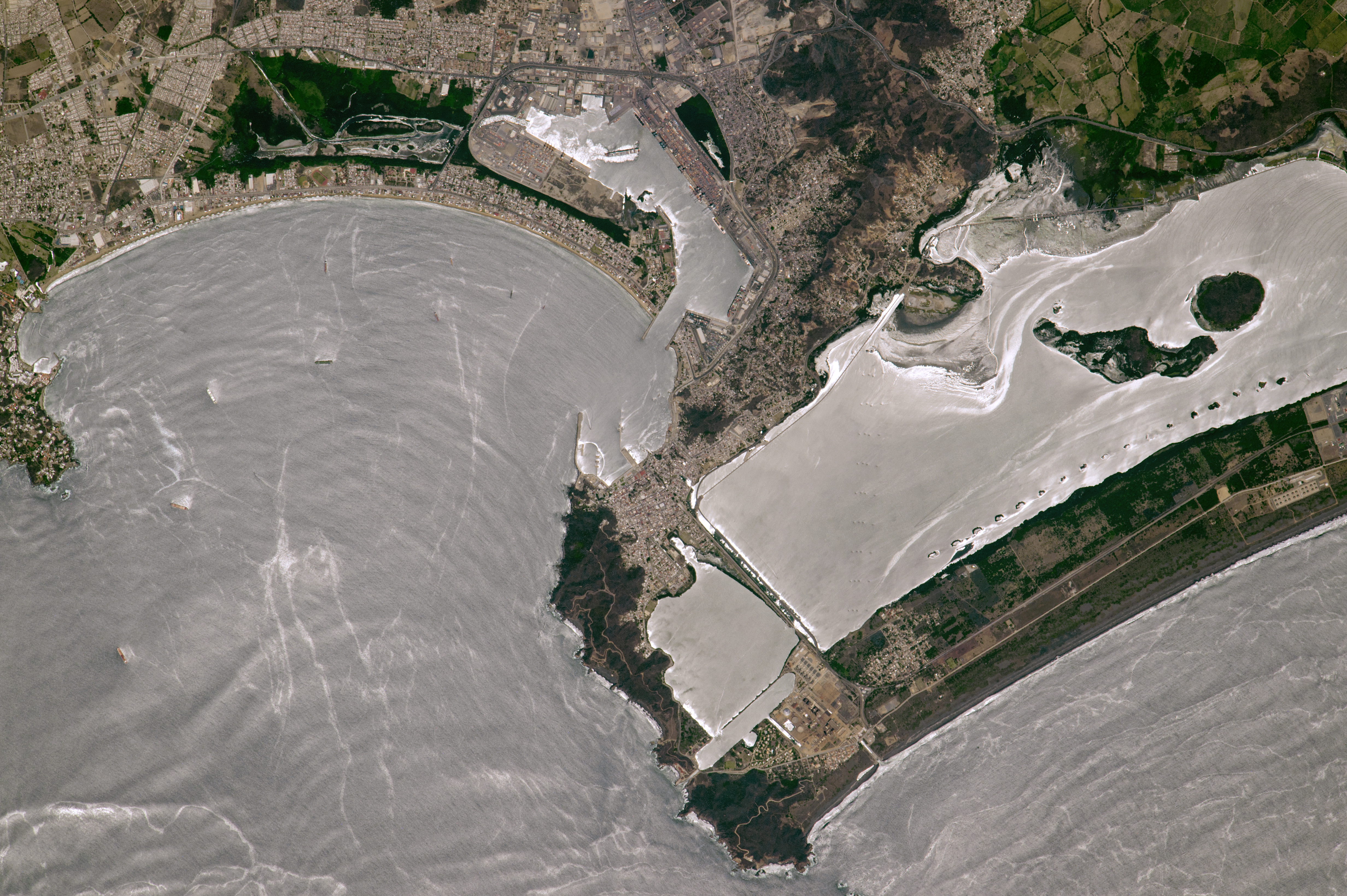
.jpg)
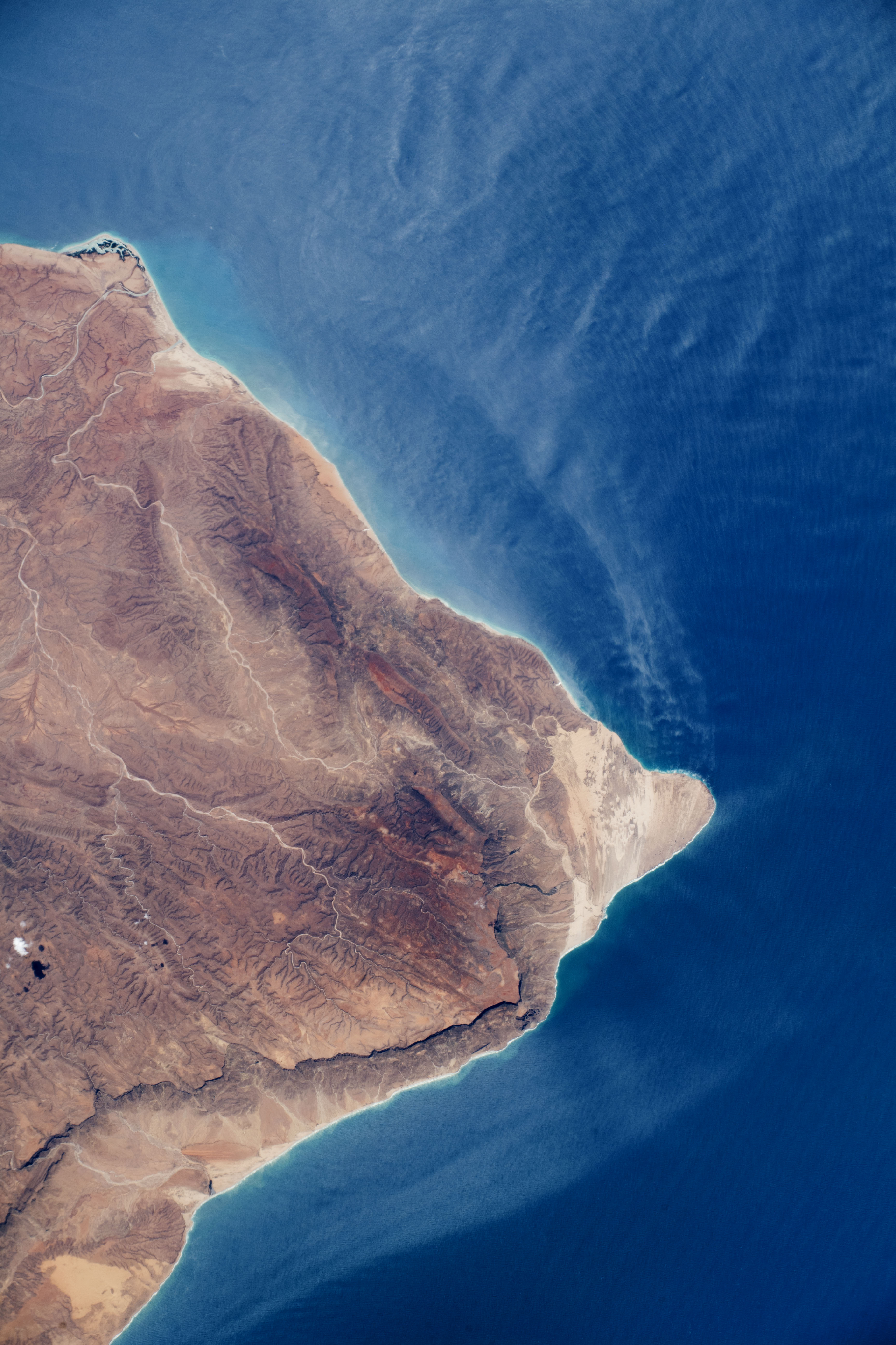
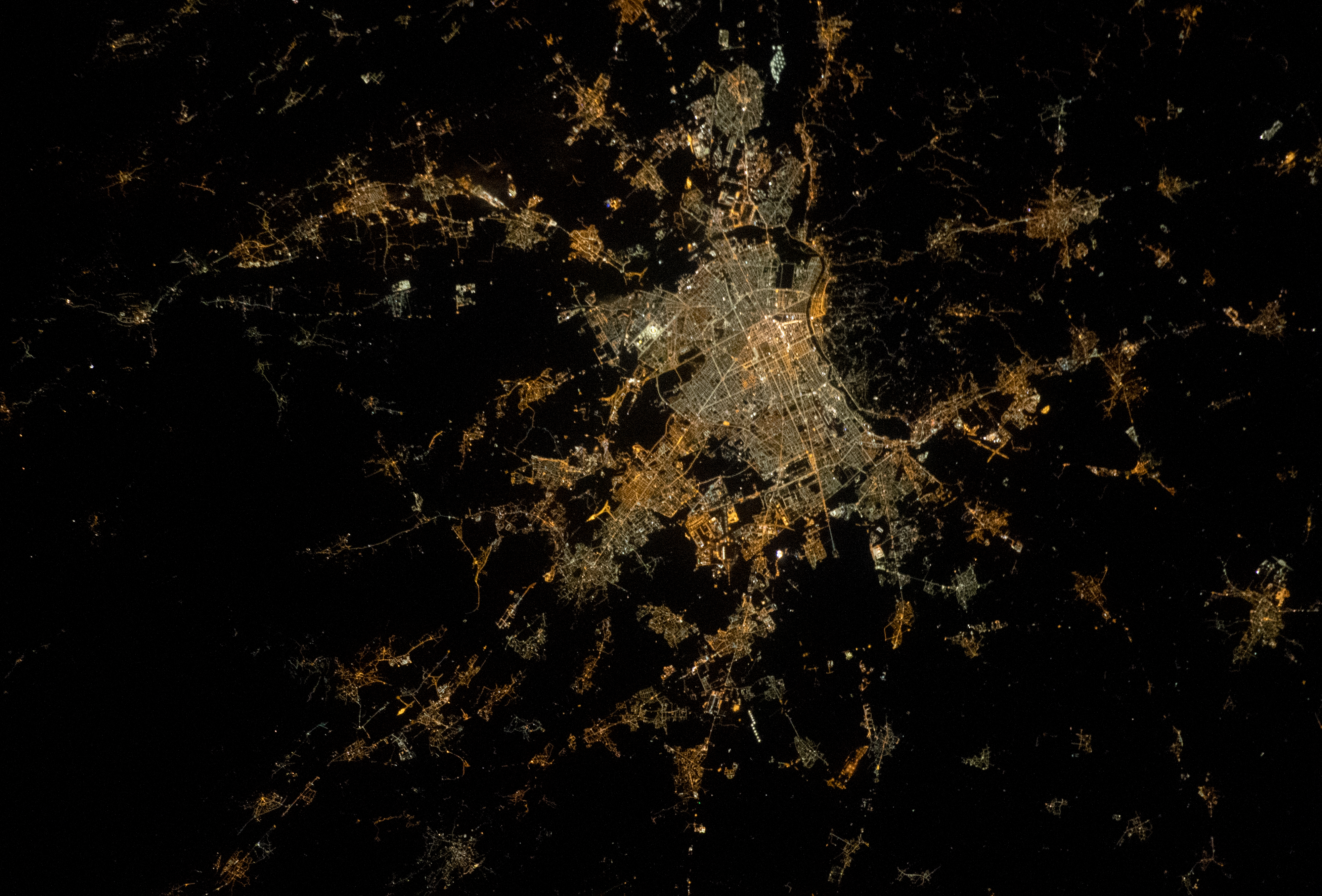