Release date: August 15, 2001
Landsat Witnesses the Destruction of Mesopotamian Ecosystem
Click here for a PDF version of the full paper.
|
|
|
|
|
|
|
|
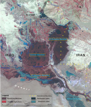
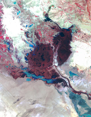
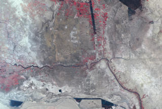
In one of the greatest ecological disasters of our time, the ancient marshlands of Mesopotamia are systematically being converted to dry salt flats as a result of human mismanagement of the region's water resources.
Landsat satellite imagery reveals that in the last 10 years, wetlands that once covered as much as 20,000 square km in parts of Iraq and Iran have been reduced to a small fraction of their original size. The authors of a new report released by the United Nations Environment Programme's (UNEP) at the 11th Stockholm Water Symposium on August 13, 2001, warn that the marshlands could completely disappear within the next 3-5 years unless dramatic steps are taken immediately to reverse the damage being done.
The UNEP Executive Director Klaus Töpfer described the wetlands' condition as " a major environmental catastrophe that will be remembered as one of humanity's worst engineered disasters." He noted that "the tragic loss of this rare wetland has occurred in approximately the same period since world leaders pledged to safeguard the environment at the United Nations Conference on Environment and Development (the Earth Summit) held in Rio de Janeiro in 1992."
Regarded by historians as one of the cradles of civilization, the Mesopotamian Fertile Crescent has supported Marsh Arab society for millennia. But through the damming and siphoning off of waters from the Tigris and Euphrates Rivers, the countries of Iran, Iraq, Turkey, and Syria have decimated the ecosystem and, with it, a culture rooted in the dawn of human history (dating back to ancient Sumeria about 5,000 years ago).
"Humanity's impact on the planet's fragile ecosystems could not be more dramatically illustrated," states Timothy Foresman, director of UNEP's Division of Early Warning and Assessment. "This Mesopotamian story is yet another wake-up call alerting us to the fraying fabric of spaceship Earth."
The problem primarily resides in the relatively recent construction of 32 major dams along the Tigris and Euphrates Rivers, well upstream of the marshlands. (Eight more dams are currently under construction and at least 13 more are planned.) The nations bordering the rivers built the dams in the late 1980s and early 1990s to provide water for irrigating croplands as well as to provide hydroelectric power for their countries. Together, these water reservoirs have the capacity to catch roughly three times more water than the entire volume that flows through both rivers.
"In any kind of human activity, there are always costs and benefits that must be taken into account," says Hassan Partow, Information and Research Officer for UNEP. (Partow is the author of the new report, entitled The Mesopotamian Marshlands: Demise of an Ecosystem.) "But if we look at this activity at a basin-wide level, we see a total lack of cooperation between countries in terms of sharing these waters in a sustainable, long-term perspective."
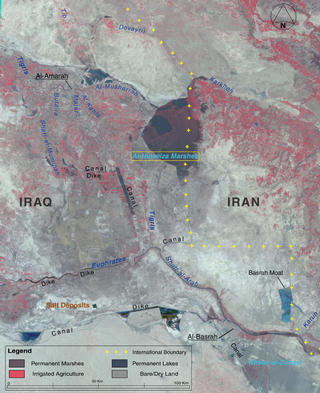
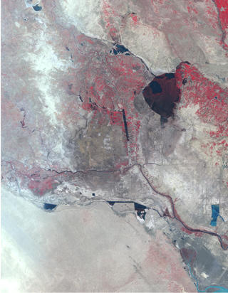
Today, flow through the Tigris and Euphrates rivers into the Mesopotamian marshlands has been reduced by about 20 percent of their original throughput and the spring floods that sustained the marshlands have been eliminated. The end result is what was once a lush, wetland environment roughly the size of the state of New Jersey has been reduced by about 85 percent in area to roughly the size of the small island state of the Bahamas. What was once a vast, interconnected mosaic of densely-vegetated marshlands and lakes, teeming with life, is now mostly lifeless desert and salt-encrusted lakebeds and riverbeds.
"Clearly, the impact has been devastating," Partow observes, "not only on the marshland ecosystem itself, but on the entire Mesopotamian basin. In terms of land cover and land use change, we have seen the wholesale transformation of the landscape in that region.
"The Marsh Arabs who inhabit this region have had their way of life shattered," Partow continues. "They are rendered into a refugee population." As many as half a million Marsh Arabs are estimated to live in the region.
Even for the 1,270 square km of marshlands that still remain, quality of life has been adversely impacted by a decline in water quality. Partow explains that human irrigation practices render the Tigris and Euphrates waters saltier than they originally were. And, with the boom in agriculture, there have been dramatic increases in the levels of chemicals as well as a rise in urban and industrial effluents in the rivers.
Conversely, most of the load of natural sediments and silts the rivers used to carry now remains trapped behind the multiple dams. Lower levels of silt decrease plankton and levels of organic carbon in the water, which, in turn, adversely affect fish populations as well as soil fertility along the riverbanks and in the marshlands.
Together, the study concludes, all of these negative trends point to the inevitable demise of the Mesopotamian marshland ecosystem, unless all countries involved can agree upon a new, common strategy for effectively managing their water resources. If the nations involved are to restore the wetlands to their original glory, or at least to preserve the wetlands that still remain, then they must periodically allow the region to flood as it has done annually for thousands of years. According to Klaus Töpfer, the goal of UNEP in this case is to broker an agreement among all the countries involved in the damming projects along the Tigris and Euphrates Rivers to discuss the region's water management issues and work together in resolving them.
Partow states that this study would not have been possible without access to Landsat imagery spanning the last three decades. "Due to the difficulty of access to the region, Landsat has been a key source of information," he says. "To be able to get a clear picture and monitor what is taking place on the ground--in terms of timeliness and cost effectiveness--the satellite data were highly effective in both ways."
This study was carried out by UNEP's Division of Early Warning and Assessment in collaboration with its Regional Office for West Asia. It is provided in the context of UNEP's mandate to review the state of the global environment and provide early warning and policy advice on emerging environmental threats and problems.
|
|
||||||
|
|
|||||||
|
|
|
||||||

|
|
|
|
|
|
|
|