Earth
ID: 30888
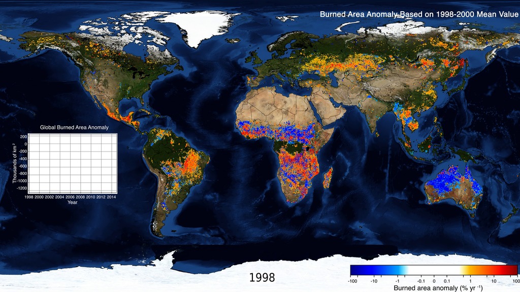
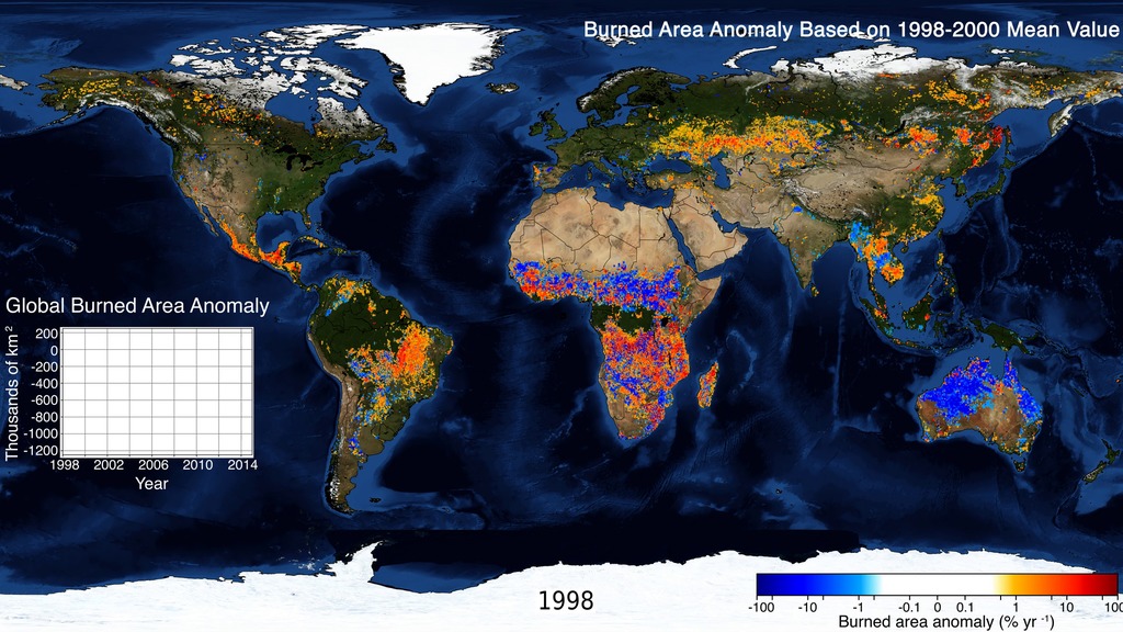
NASA satellite data provide a consistent global record of fire activity. Years with more fire (red) and less fire (blue) highlight how different biomes respond to climate variability. In forests and the humid tropics, most burning occurs in dry years. In more arid savannas, wetter years increase burned area—more rainfall grows more grass, adding fuel for future fires.
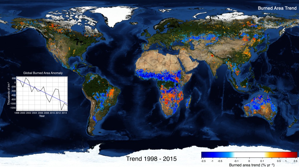
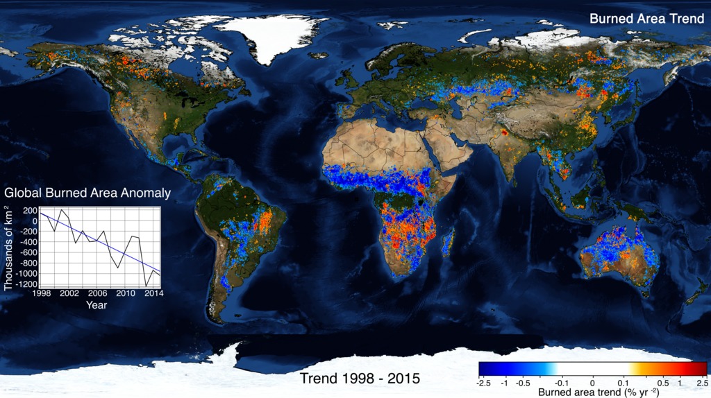
During 1998-2015, global burned area declined by nearly 25%. The trend map shows strong declines in burned area (blue) across the savannas and grasslands of Africa, the Eurasian Steppe, and South America. A rapid increase in agriculture, livestock, and population reduced burning in these highly flammable ecosystems. Less burning has benefits, including improved air quality and increasing the land carbon sink. However, less frequent burning may convert open savannas into shrublands or woodlands, eliminating habitat for many endemic species, including iconic lions, elephants, and other large mammals.
A Human-Driven Decline in Global Burned Area
During 1998-2015, global burned area declined by nearly 25%. The trend map shows strong declines in burned area (blue) across the savannas and grasslands of Africa, the Eurasian Steppe, and South America. A rapid increase in agriculture, livestock, and population reduced burning in these highly flammable ecosystems. Less burning has benefits, including improved air quality and increasing the land carbon sink. However, less frequent burning may convert open savannas into shrublands or woodlands, eliminating habitat for many endemic species, including iconic lions, elephants, and other large mammals.
For More Information
Credits
Amy Moran (Global Science and Technology, Inc.): Lead Data Visualizer
Doug C. Morton (NASA/GSFC): Lead Scientist
Niels Andela (Science Collaborator): Lead Scientist
Doug C. Morton (NASA/GSFC): Lead Scientist
Niels Andela (Science Collaborator): Lead Scientist
Please give credit for this item to:
NASA's Goddard Space Flight Center
NASA's Goddard Space Flight Center
Science Paper:
http://science.sciencemag.org/content/356/6345/1356
Short URL to share this page:
https://svs.gsfc.nasa.gov/30888
Keywords:
SVS >> Burn Scar
SVS >> Grasslands
SVS >> HDTV
SVS >> Time Series
GCMD >> Earth Science >> Biosphere >> Terrestrial Ecosystems >> Grasslands
GCMD >> Earth Science >> Biosphere >> Terrestrial Ecosystems >> Savannas
GCMD >> Earth Science >> Human Dimensions >> Natural Hazards >> Fires
SVS >> Hyperwall
NASA Science >> Earth
GCMD keywords can be found on the Internet with the following citation: Olsen, L.M., G. Major, K. Shein, J. Scialdone, S. Ritz, T. Stevens, M. Morahan, A. Aleman, R. Vogel, S. Leicester, H. Weir, M. Meaux, S. Grebas, C.Solomon, M. Holland, T. Northcutt, R. A. Restrepo, R. Bilodeau, 2013. NASA/Global Change Master Directory (GCMD) Earth Science Keywords. Version 8.0.0.0.0


