Earth
ID: 30699
Each year, peat fires start to burn in Indonesia because farmers engage in slash and burn agriculture—a technique that involves frequent burning of rainforest to clear the way for crops or grazing animals. The intent is often to make room for new plantings of oil palm and acacia pulp. In October 2015 more than 94,000 fires had burned across the island nation, affecting the health of millions of people in Indonesia, Malaysia, and Singapore. On September 24, 2015, dense haze carried by southerly winds was blown into Singapore. The PSI reading at 7:00 PM local time rose into the "Hazardous" range for the first time in 2015 with a reading of 313. It rose further to 317 at 8:00 PM, which prompted the Ministry of Education to close all primary and secondary schools on September 25. The haze deteriorated further by September 25, reaching a record high for the year at 5:00 AM with a reading of 341. Anti-pollution masks were distributed to the elderly and other vulnerable people. The smoke—which is an annual problem for the region—is a serious health hazard, especially for the elderly, children, and those with breathing problems.
Hazardous Air Quality Conditions in Singapore
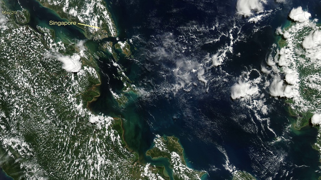
This set of images shows Singapore and the nearby region on May 29, 2015, when air quality conditions were normal, and on September 25, 2015, when a thick smoky haze covered the nation. Each image reveals a true-color image [top] from the Moderate Resolution Imaging Spectroradiometer (MODIS) and atmospheric cross-section [bottom] from the Cloud-Aerosol Lidar and Infrared Pathfinder Satellite Observation (CALIPSO). The CALIPSO image from September 25 reveals the thick layer of smoke (dark orange) in the atmosphere.
Credits
Please give credit for this item to:
NASA's Goddard Space Flight Center
NASA's Goddard Space Flight Center
Short URL to share this page:
https://svs.gsfc.nasa.gov/30699
Missions:
Aqua
CALIPSO
Data Used:
Note: While we identify the data sets used in these visualizations, we do not store any further details nor the data sets themselves on our site.
Keywords:
SVS >> HDTV
SVS >> Smoke
GCMD >> Earth Science >> Atmosphere >> Air Quality
GCMD >> Earth Science >> Human Dimensions >> Natural Hazards >> Fires
SVS >> Hyperwall
SVS >> Calipso
SVS >> MODIS
SVS >> Aqua
NASA Science >> Earth
SVS >> Presentation
NASA Earth Science Focus Areas >> Atmospheric Composition
GCMD keywords can be found on the Internet with the following citation: Olsen, L.M., G. Major, K. Shein, J. Scialdone, S. Ritz, T. Stevens, M. Morahan, A. Aleman, R. Vogel, S. Leicester, H. Weir, M. Meaux, S. Grebas, C.Solomon, M. Holland, T. Northcutt, R. A. Restrepo, R. Bilodeau, 2013. NASA/Global Change Master Directory (GCMD) Earth Science Keywords. Version 8.0.0.0.0
https://svs.gsfc.nasa.gov/30699
Missions:
Aqua
CALIPSO
Data Used:
Aqua/MODIS
CALIPSO/CALIOP/Total Attenuated Backscatter
Keywords:
SVS >> HDTV
SVS >> Smoke
GCMD >> Earth Science >> Atmosphere >> Air Quality
GCMD >> Earth Science >> Human Dimensions >> Natural Hazards >> Fires
SVS >> Hyperwall
SVS >> Calipso
SVS >> MODIS
SVS >> Aqua
NASA Science >> Earth
SVS >> Presentation
NASA Earth Science Focus Areas >> Atmospheric Composition
GCMD keywords can be found on the Internet with the following citation: Olsen, L.M., G. Major, K. Shein, J. Scialdone, S. Ritz, T. Stevens, M. Morahan, A. Aleman, R. Vogel, S. Leicester, H. Weir, M. Meaux, S. Grebas, C.Solomon, M. Holland, T. Northcutt, R. A. Restrepo, R. Bilodeau, 2013. NASA/Global Change Master Directory (GCMD) Earth Science Keywords. Version 8.0.0.0.0


