Earth
ID: 11042
In Southwestern Louisiana, many forces have combined to have a pronounced effect on this unique part of the country. Not only the wandering of the lower Mississippi River over the centuries and periodic hurricanes, but also past and current human enterprises have shaped the landscape.
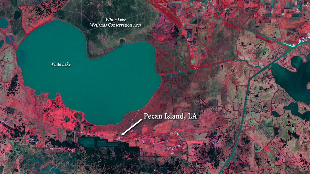
The Chénier Plain in southwest Louisiana consists of marshes as well as ridges – chéniers - formed of sand and shell sediments and shaped by ancient currents and wave actions of the Gulf of Mexico. These elevated chéniers, a few meters tall at their highest parts, are preferred sites for the region’s residents due to their protection from flooding. The original chénier inhabitants, such as those in the Pecan Island area of Vermilion Parish, made their living off the surrounding wetlands by farming, fishing, hunting, and trapping. More recently, livelihoods include employment in the oil and gas industry.
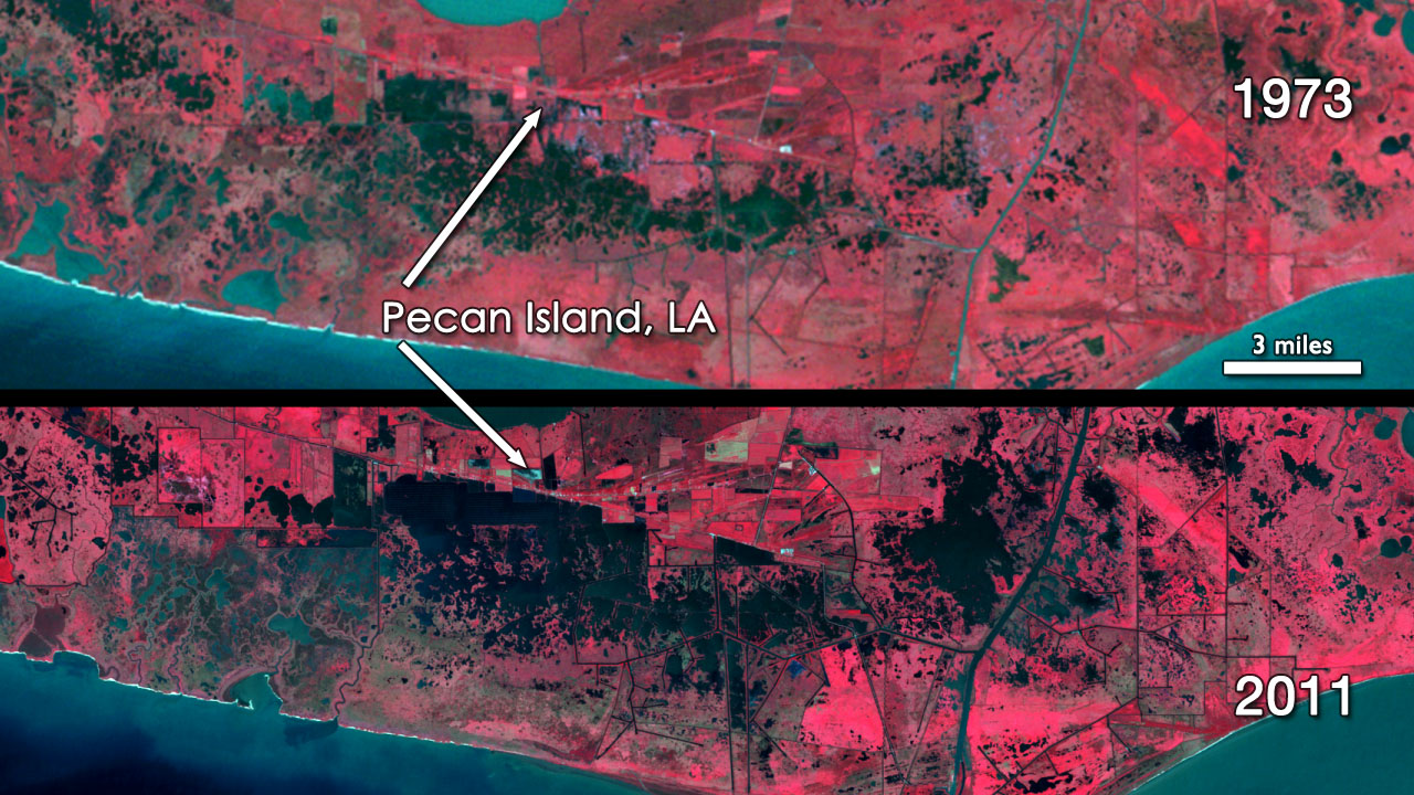
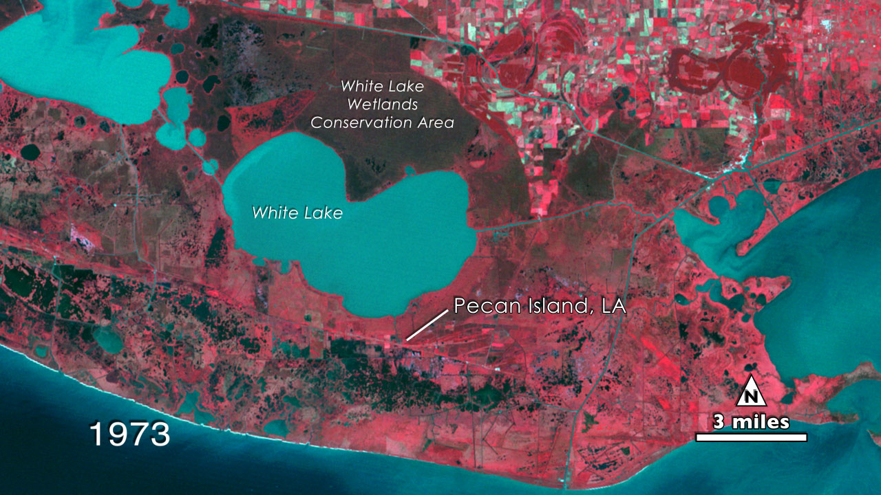
The 1973 Landsat image shows considerable amounts of open water in smooth colors ranging from turquoise to dark blues. Marshes are represented by the mosaic of reds and dark shades, such as those south of the thin straight line that is the highway along the Pecan Island ridge.
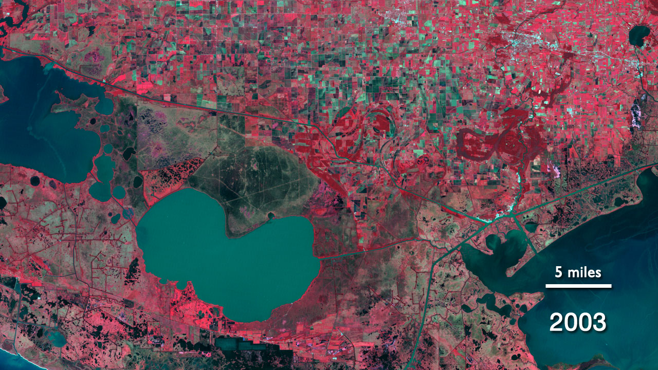
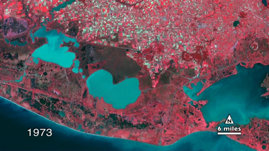
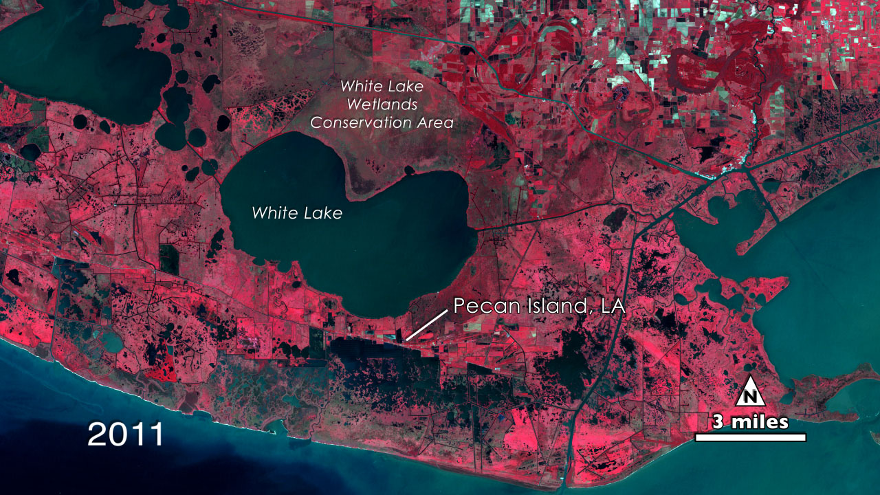
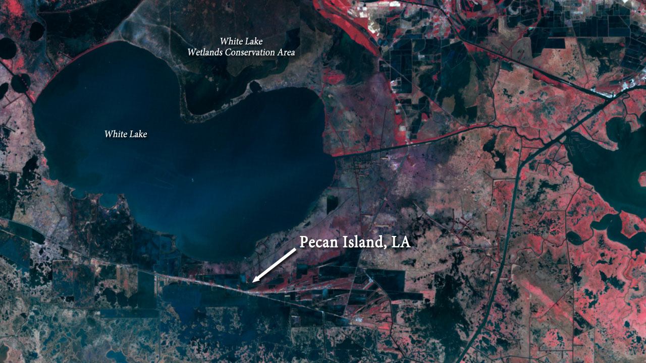
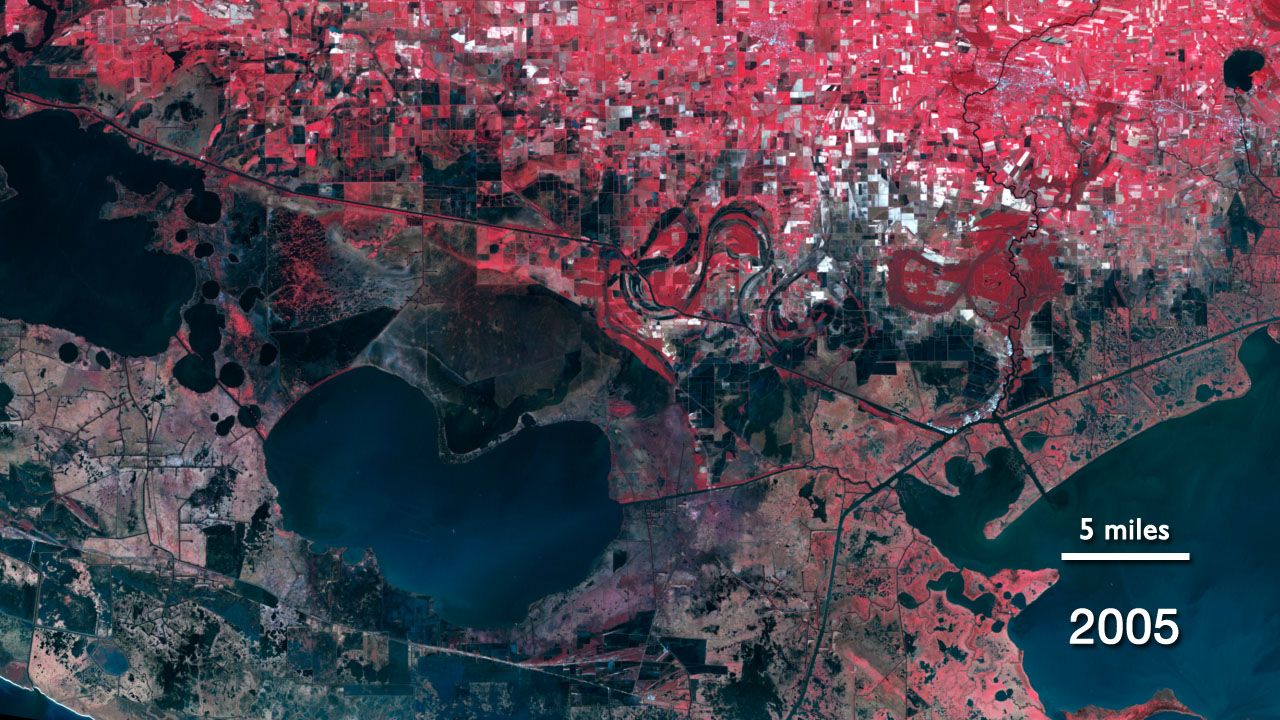
This sequence of six Landsat images is centered on the community of Pecan Island in Vermilion Parish, located on a chénier between the salty Gulf of Mexico to the south and freshwater White Lake to the north, show major changes across this low-lying ecologically-rich region.
As you look these images spanning 1973 to 2011, you will see the increase in open water – and loss of salt marshes, and also the loss of farm fields south of Pecan Island.
Perhaps most pronounced are the changes in the regions’s marshes, which are caused, in part, by the impacts from distant engineering efforts to control the lower Mississippi River off to the east. The changes are also due to the shipping and access canals visible in the sequence of images. As the canals cut through the region, the flow of water was disrupted and the dredging spoil banks impounded marshes.
As a result of these forces, sediments from the Mississippi no longer spread over the marshes and the connectivity between the lakes and marshes has changed. Upland farmed areas that had been dry in 1973 just south of Pecan Island were covered by open water in 1980. These structural controls have made the marshes less resilient in repairing themselves after major storms such as hurricanes.
Hurricanes, including Danny in 1985 and Rita in 2005, inundated marshes and surrounded Pecan Island with floodwaters, as well as flooding agricultural fields – such as those southeast of Pecan Island. The higher chéniers provided storm surge protection to the community but the combination of salt water intrusion and hurricanes have led to the abandonment of the farm land.
Over the last century, rising sea levels and a subsiding coast have added to a changing southern Louisiana landscape where open water is slowly displacing marshes. These changes were already happening when the first Landsat was launched in 1972 and observations from subsequent Landsats have recorded the continuing regional changes.
The southern Louisiana community, including Mr. Brent Yantis and Dr. Whitney Broussard, who entered the "My American Landscape" contest on behalf of the University of Louisiana at Lafayette has rallied behind the people of the Chénier Plain and are researching sustainability plans for Pecan Island and other communities to live in this dynamic environment. A future, they hope, that will maintain the cultural and ecosystem resiliency of this uniquely American landscape.
Vermilion Parish, LA
The Chénier Plain in southwest Louisiana consists of marshes as well as ridges – chéniers - formed of sand and shell sediments and shaped by ancient currents and wave actions of the Gulf of Mexico. These elevated chéniers, a few meters tall at their highest parts, are preferred sites for the region’s residents due to their protection from flooding. The original chénier inhabitants, such as those in the Pecan Island area of Vermilion Parish, made their living off the surrounding wetlands by farming, fishing, hunting, and trapping. More recently, livelihoods include employment in the oil and gas industry.
This sequence of six Landsat images is centered on the community of Pecan Island in Vermilion Parish, located on a chénier between the salty Gulf of Mexico to the south and freshwater White Lake to the north, show major changes across this low-lying ecologically-rich region.
As you look these images spanning 1973 to 2011, you will see the increase in open water – and loss of salt marshes, and also the loss of farm fields south of Pecan Island.
Perhaps most pronounced are the changes in the regions’s marshes, which are caused, in part, by the impacts from distant engineering efforts to control the lower Mississippi River off to the east. The changes are also due to the shipping and access canals visible in the sequence of images. As the canals cut through the region, the flow of water was disrupted and the dredging spoil banks impounded marshes.
As a result of these forces, sediments from the Mississippi no longer spread over the marshes and the connectivity between the lakes and marshes has changed. Upland farmed areas that had been dry in 1973 just south of Pecan Island were covered by open water in 1980. These structural controls have made the marshes less resilient in repairing themselves after major storms such as hurricanes.
Hurricanes, including Danny in 1985 and Rita in 2005, inundated marshes and surrounded Pecan Island with floodwaters, as well as flooding agricultural fields – such as those southeast of Pecan Island. The higher chéniers provided storm surge protection to the community but the combination of salt water intrusion and hurricanes have led to the abandonment of the farm land.
Over the last century, rising sea levels and a subsiding coast have added to a changing southern Louisiana landscape where open water is slowly displacing marshes. These changes were already happening when the first Landsat was launched in 1972 and observations from subsequent Landsats have recorded the continuing regional changes.
The southern Louisiana community, including Mr. Brent Yantis and Dr. Whitney Broussard, who entered the "My American Landscape" contest on behalf of the University of Louisiana at Lafayette has rallied behind the people of the Chénier Plain and are researching sustainability plans for Pecan Island and other communities to live in this dynamic environment. A future, they hope, that will maintain the cultural and ecosystem resiliency of this uniquely American landscape.
For More Information
https://www.nasa.gov/mission_pages/landsat/news/40th-landscapes-lafayetteLA.html
http://landsat.gsfc.nasa.gov/news/news-archive/news_0490.html
Credits
Matthew R. Radcliff (USRA): Producer
Roger Auch (USGS): Writer
Ellen T. Gray (ADNET Systems, Inc.): Writer
Roger Auch (USGS): Scientist
James R. Irons (NASA/GSFC): Scientist
Roger Auch (USGS): Writer
Ellen T. Gray (ADNET Systems, Inc.): Writer
Roger Auch (USGS): Scientist
James R. Irons (NASA/GSFC): Scientist
Please give credit for this item to:
NASA/Goddard Space Flight Center
Landsat is a joint program of NASA and USGS:
http://landsat.usgs.gov
http://www.nasa.gov/landsat
NASA/Goddard Space Flight Center
Landsat is a joint program of NASA and USGS:
http://landsat.usgs.gov
http://www.nasa.gov/landsat
Short URL to share this page:
https://svs.gsfc.nasa.gov/11042
Missions:
Landsat
LDCM: Landsat Data Continuity Mission
This item is part of this series:
Geophysical Changes Over Time
Keywords:
SVS >> HDTV
DLESE >> Hydrology
SVS >> Landsat
GCMD >> Earth Science >> Hydrosphere >> Surface Water >> Wetlands
GCMD >> Earth Science >> Oceans >> Coastal Processes >> Sea Level Rise
SVS >> Hyperwall
NASA Science >> Earth
GCMD keywords can be found on the Internet with the following citation: Olsen, L.M., G. Major, K. Shein, J. Scialdone, S. Ritz, T. Stevens, M. Morahan, A. Aleman, R. Vogel, S. Leicester, H. Weir, M. Meaux, S. Grebas, C.Solomon, M. Holland, T. Northcutt, R. A. Restrepo, R. Bilodeau, 2013. NASA/Global Change Master Directory (GCMD) Earth Science Keywords. Version 8.0.0.0.0


