Planets and Moons
ID: 5038
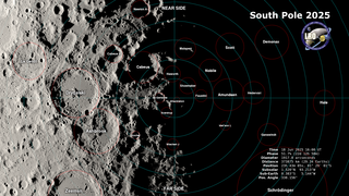
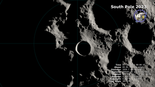
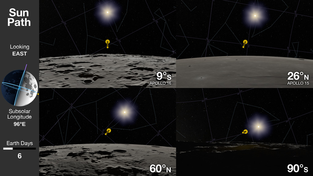
On both the Earth and the Moon, the apparent path of the Sun in the sky during the day depends on the observer's latitude. At most latitudes, the Sun rises above the eastern horizon in the morning, arcs through the sky toward a peak altitude at local noon, then sinks below the western horizon in the evening, the only difference being the steepness of the arc. The Sun's apparent motion at the poles is markedly different, particularly on the Moon, which is tilted only 1.5° relative to the Sun.
This visualization compares Sun views from four latitudes on the Moon over the course of a lunar day. The two views in the upper half of the frame are from Apollo landing sites. The lower left shows a latitude much higher than any Apollo landing, while the lower right is the view from the South Pole, where rather than rising and setting, the Sun travels in a complete circle, skimming low over the horizon. The yellow arrow points toward the Sun, locating it even when it's hidden below the horizon or outside the image frame. The sidebar shows the direction of the Sun's rays in a view from Earth, as well as the elapsed time in Earth days.
The Sun's Path at Different Lunar Latitudes
This visualization compares Sun views from four latitudes on the Moon over the course of a lunar day. The two views in the upper half of the frame are from Apollo landing sites. The lower left shows a latitude much higher than any Apollo landing, while the lower right is the view from the South Pole, where rather than rising and setting, the Sun travels in a complete circle, skimming low over the horizon. The yellow arrow points toward the Sun, locating it even when it's hidden below the horizon or outside the image frame. The sidebar shows the direction of the Sun's rays in a view from Earth, as well as the elapsed time in Earth days.
Related
Visualization Credits
Ernie Wright (USRA): Lead Visualizer
Jacob Bleacher (NASA/GSFC): Scientist
Laurence Schuler (ADNET Systems, Inc.): Technical Support
Ian Jones (ADNET Systems, Inc.): Technical Support
Jacob Bleacher (NASA/GSFC): Scientist
Laurence Schuler (ADNET Systems, Inc.): Technical Support
Ian Jones (ADNET Systems, Inc.): Technical Support
Please give credit for this item to:
NASA's Scientific Visualization Studio
NASA's Scientific Visualization Studio
Short URL to share this page:
https://svs.gsfc.nasa.gov/5038
Mission:
Artemis Program (Human Spaceflight — Moon to Mars)
Data Used:
Note: While we identify the data sets used in these visualizations, we do not store any further details nor the data sets themselves on our site.
This item is part of this series:
The Moon
Keywords:
SVS >> HDTV
SVS >> Moon
SVS >> Hyperwall
SVS >> LRO
SVS >> Lunar Reconnaissance Orbiter
SVS >> Sun-Earth-Moon Interactions
SVS >> Moon >> South Pole
NASA Science >> Planets and Moons
SVS >> Artemis
https://svs.gsfc.nasa.gov/5038
Mission:
Artemis Program (Human Spaceflight — Moon to Mars)
Data Used:
LRO/LOLA/Digital Elevation Map also referred to as: DEM
JPL DE421 also referred to as: DE421
Ephemeris - NASA/JPL
Planetary ephemerides
LRO/SELENE/LOLA/TC/DIgital Elevation Model also referred to as: SLDEM2015
Model
A digital elevation model of the Moon derived from the Lunar Orbiter Laser Altimeter and the SELENE Terrain Camera. See the description in Icarus. The data is here.
Lunar Reconnaissance Orbiter/LRO Camera/Natural Color Hapke Normalized WAC Mosaic also referred to as: LROC WAC Color Mosaic
Mosaic - Arizona State University
This natural-color global mosaic is based on the 'Hapke normalized' mosaic from LRO's wide-angle camera. The data has been gamma corrected, white balanced, and range adjusted to more closely match human vision.
This item is part of this series:
The Moon
Keywords:
SVS >> HDTV
SVS >> Moon
SVS >> Hyperwall
SVS >> LRO
SVS >> Lunar Reconnaissance Orbiter
SVS >> Sun-Earth-Moon Interactions
SVS >> Moon >> South Pole
NASA Science >> Planets and Moons
SVS >> Artemis


