May 26, 2021 Total Lunar Eclipse: Visibility Map
An animated map showing where the May 26, 2021 lunar eclipse is visible.
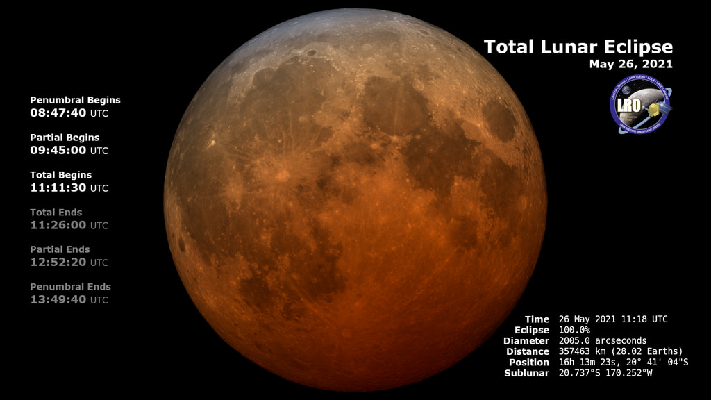
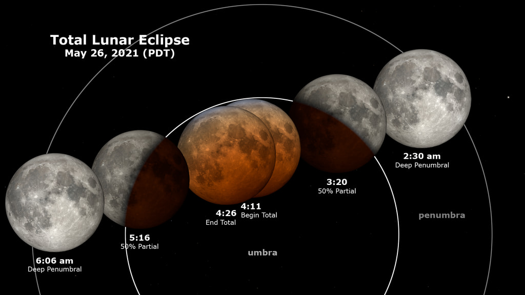
On May 26, 2021, during early morning in the western Americas, the Moon enters the Earth's shadow, creating a total lunar eclipse, the first in almost two and a half years. This animation shows the region of the Earth where this eclipse is visible. This region shifts to the west during the eclipse. Observers near the edge of the visibility region may see only part of the eclipse because for them, the Moon sets (on the eastern or right-hand edge) or rises (on the western or left-hand edge) while the eclipse is happening.
Contour lines mark the edge of the visibility region at the contact times. These are the times when the Moon enters or leaves the umbra (the part of the Earth's shadow where the Sun is completely hidden) and penumbra (the part where the Sun is only partially blocked). For observers located on a contour line, the contact occurs at moonrise (west) or moonset (east).

A map showing where the May 26, 2021 lunar eclipse is visible. Contours mark the edge of the visibility region at eclipse contact times. The map is centered on 170°15'W, the sublunar longitude at mid-eclipse.
Visibility of the total phase in the contiguous U.S., at 11:11 UTC. Totality can be seen everywhere in the Pacific and Mountain time zones, along with Texas, Oklahoma, western Kansas, Hawaii and Alaska.
Visibility of the start of the partial phase in the contiguous U.S., at 9:45 UTC. This can be seen everywhere (including Puerto Rico) except eastern Pennsylvania, eastern Delaware, New York east of Buffalo, and the rest of New England.
The mask defining the visibility region, centered at 0° longitude.
Credits
Please give credit for this item to:
NASA's Scientific Visualization Studio
-
Visualizer
- Ernie Wright (USRA)
-
Producer
- David Ladd (USRA)
-
Scientist
- Noah Petro (NASA/GSFC)
-
Technical support
- Laurence Schuler (ADNET Systems, Inc.)
- Ian Jones (ADNET Systems, Inc.)
Release date
This page was originally published on Monday, May 3, 2021.
This page was last updated on Monday, July 15, 2024 at 12:09 AM EDT.
Missions
This visualization is related to the following missions:Datasets used in this visualization
-
Earth at Night [DMSP: OLS]
ID: 286 -
DE421 (JPL DE421)
ID: 752Planetary ephemerides
This dataset can be found at: http://ssd.jpl.nasa.gov/?ephemerides#planets
See all pages that use this dataset
Note: While we identify the data sets used in these visualizations, we do not store any further details, nor the data sets themselves on our site.
Related
- ID: 13861
- ID: 4902
 Visualization
 - ID: 4903
 Visualization