Planets and Moons
ID: 4185
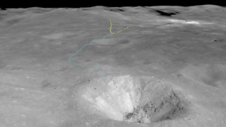
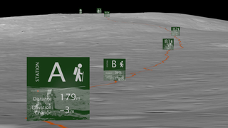
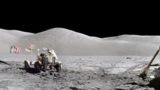
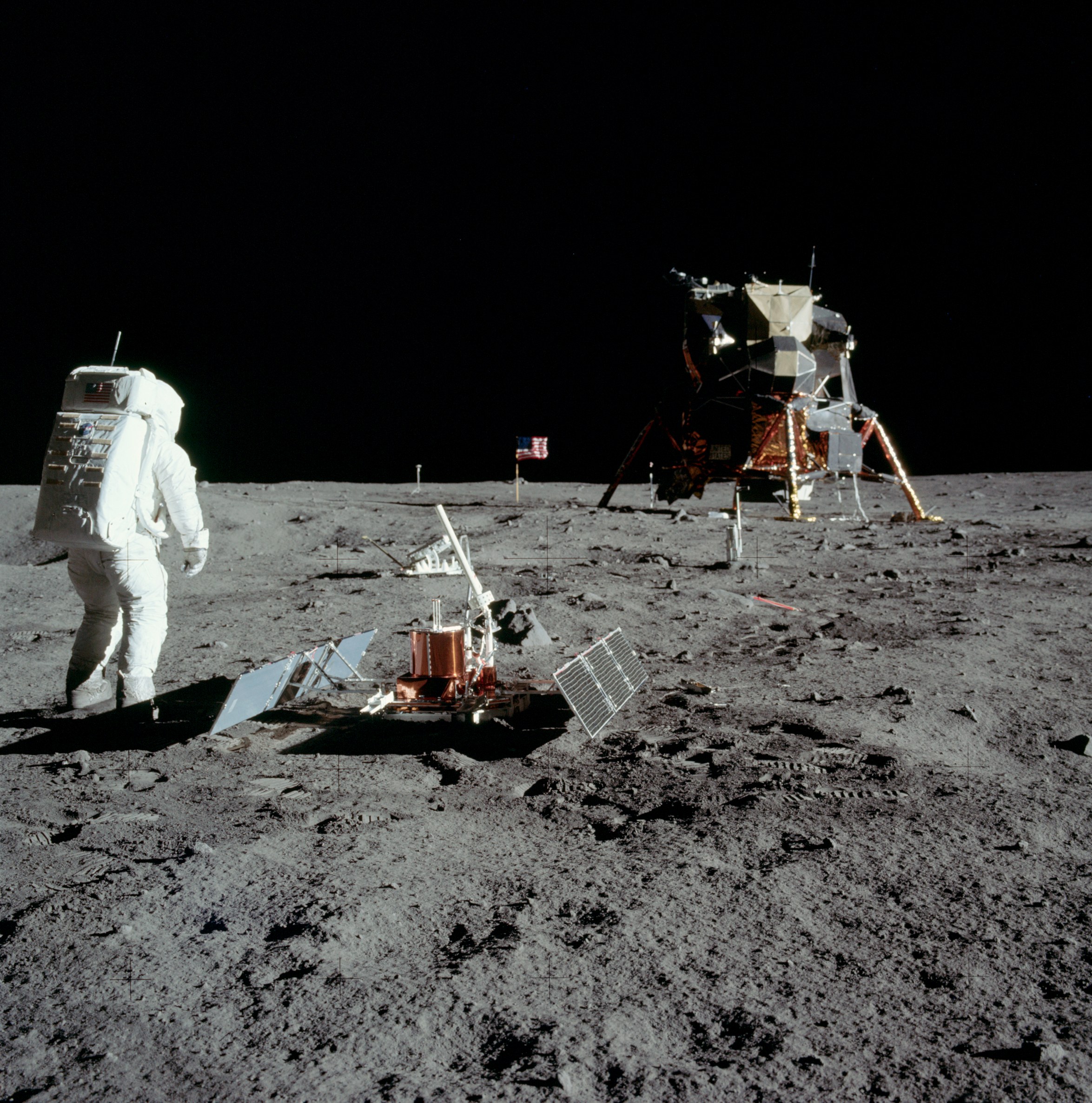
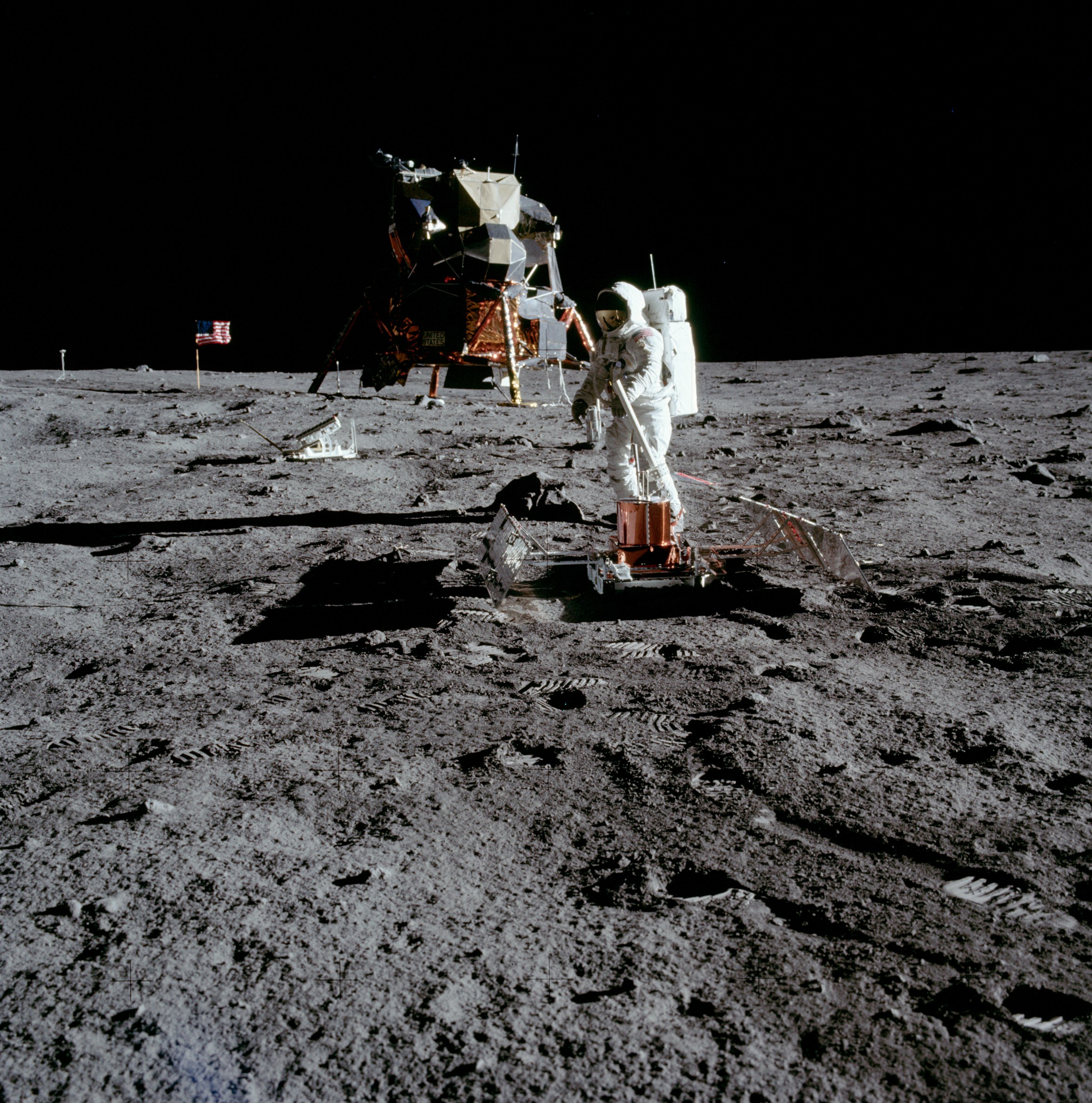
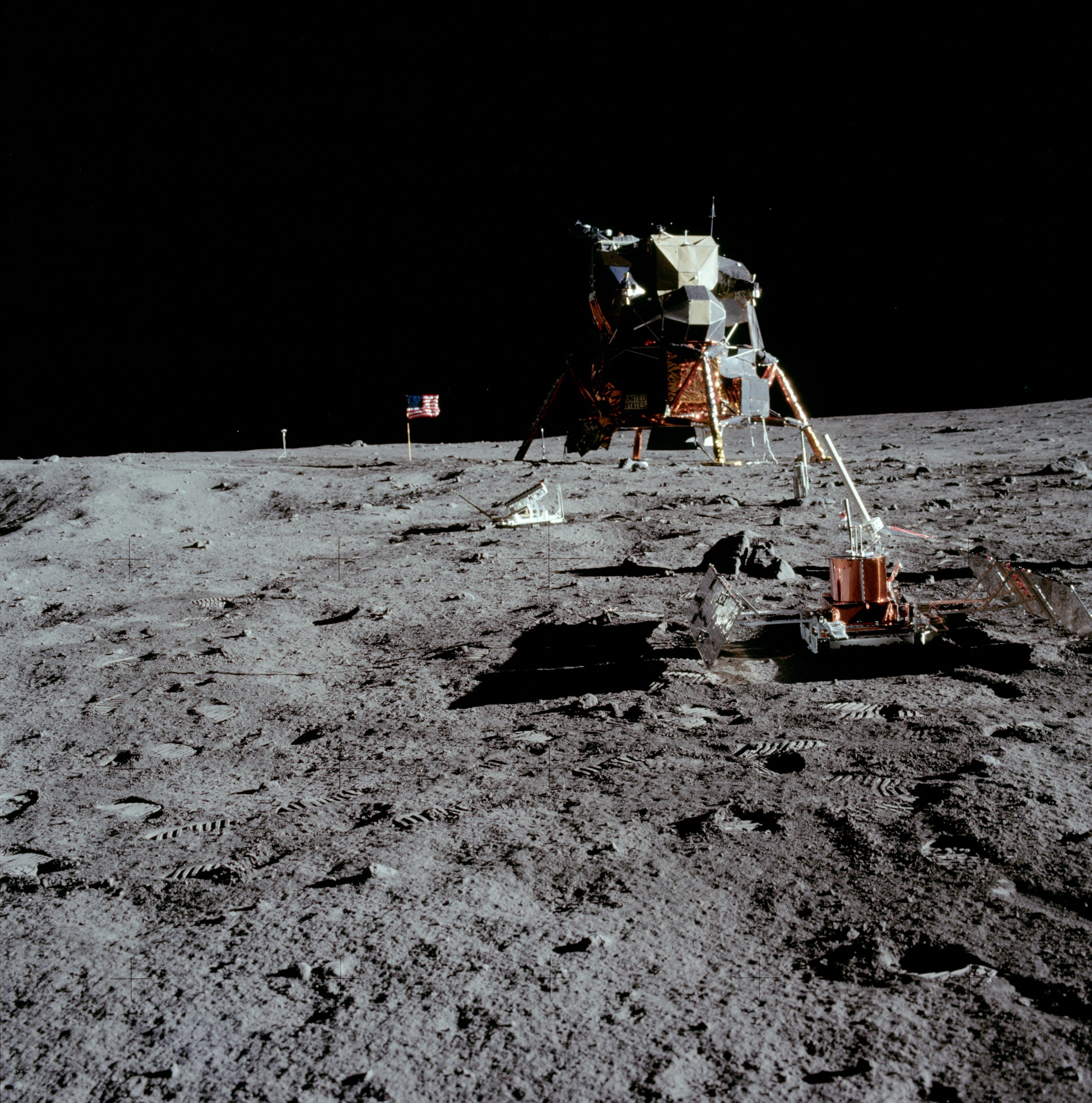
Apollo 11 landed on the Moon on July 20th, 1969, a little after 4:00 in the afternoon Eastern Daylight Time. The Lunar Module, nicknamed Eagle and flown by Neil Armstrong and Edwin "Buzz" Aldrin, touched down near the southern rim of the Sea of Tranquility, one of the large, dark basins that contribute to the Man in the Moon visible from Earth. Armstrong and Aldrin spent about two hours outside the LM setting up experiments and collecting samples. At one point, Armstrong ventured east of the LM to examine a small crater, dubbed Little West, that he'd flown over just before landing.
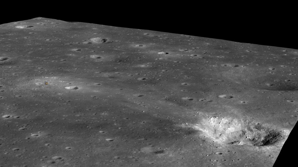
The trails of disturbed regolith created by the astronauts' boots are still clearly visible in photographs of the landing site taken by the Lunar Reconnaissance Orbiter (LRO) narrow-angle camera (LROC) more than four decades later.
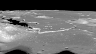
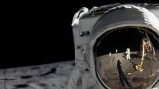
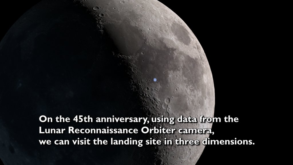
LROC imagery makes it possible to visit the landing site in a whole new way by flying around a three-dimensional model of the site. LROC scientists created the digital elevation model using a stereo pair of images. Each image in the pair shows the site from a slightly different angle, allowing sophisticated software to infer the shape of the terrain, similar to the way that left and right eye views are combined in the brain to produce the perception of depth.
The animator draped an LROC photograph over the terrain model. He also added a 3D model of the LM descent stage—the real LM in the photograph looks oddly flat when viewed at an oblique angle.
Although the area around the site is relatively flat by lunar standards, West Crater (the big brother of the crater visited by Armstrong) appears in dramatic relief near the eastern edge of the terrain model. Ejecta from West comprises the boulders that Armstrong had to avoid as he searched for a safe landing site.
Apollo 11 was the first of six increasingly ambitious crewed lunar landings. The exploration of the lunar surface by the Apollo astronauts, when combined with the wealth of remote sensing data now being returned by LRO, continues to inform our understanding of our nearest neighbor in space.

A New Look at the Apollo 11 Landing Site
The trails of disturbed regolith created by the astronauts' boots are still clearly visible in photographs of the landing site taken by the Lunar Reconnaissance Orbiter (LRO) narrow-angle camera (LROC) more than four decades later.
LROC imagery makes it possible to visit the landing site in a whole new way by flying around a three-dimensional model of the site. LROC scientists created the digital elevation model using a stereo pair of images. Each image in the pair shows the site from a slightly different angle, allowing sophisticated software to infer the shape of the terrain, similar to the way that left and right eye views are combined in the brain to produce the perception of depth.
The animator draped an LROC photograph over the terrain model. He also added a 3D model of the LM descent stage—the real LM in the photograph looks oddly flat when viewed at an oblique angle.
Although the area around the site is relatively flat by lunar standards, West Crater (the big brother of the crater visited by Armstrong) appears in dramatic relief near the eastern edge of the terrain model. Ejecta from West comprises the boulders that Armstrong had to avoid as he searched for a safe landing site.
Apollo 11 was the first of six increasingly ambitious crewed lunar landings. The exploration of the lunar surface by the Apollo astronauts, when combined with the wealth of remote sensing data now being returned by LRO, continues to inform our understanding of our nearest neighbor in space.
Related


Visualization Credits
Ernie Wright (USRA): Lead Animator
David Ladd (USRA): Producer
Andrew Chaikin: Producer
Noah Petro (NASA/GSFC): Scientist
Laurence Schuler (ADNET Systems, Inc.): Project Support
Ian Jones (ADNET Systems, Inc.): Project Support
David Ladd (USRA): Producer
Andrew Chaikin: Producer
Noah Petro (NASA/GSFC): Scientist
Laurence Schuler (ADNET Systems, Inc.): Project Support
Ian Jones (ADNET Systems, Inc.): Project Support
Please give credit for this item to:
NASA's Scientific Visualization Studio
NASA's Scientific Visualization Studio
Short URL to share this page:
https://svs.gsfc.nasa.gov/4185
Missions:
Apollo
LRO (Lunar Reconnaissance Orbiter)
Data Used:
Note: While we identify the data sets used in these visualizations, we do not store any further details nor the data sets themselves on our site.
This item is part of these series:
Narrated Movies
The Moon
LRO - Animations
Goddard TV Tape:
G2014-064 -- Apollo11 Landing Site
Keywords:
SVS >> Elevation data
SVS >> Flyover
SVS >> HDTV
SVS >> Landing Site
SVS >> Laser Altimeter
SVS >> Lunar
SVS >> Moon
SVS >> Hyperwall
SVS >> LRO
SVS >> Lunar Reconnaissance Orbiter
SVS >> LROC
SVS >> Apollo Missions
SVS >> Lunar Topography
SVS >> Lunar Elevation Map
SVS >> Solar System >> Moon >> Lunar Surface
NASA Science >> Planets and Moons
https://svs.gsfc.nasa.gov/4185
Missions:
Apollo
LRO (Lunar Reconnaissance Orbiter)
Data Used:
LRO/LROC/Narrow Angle Camera also referred to as: NAC
2011-11-05 02:34:24LRO/LROC NAC/Stereo DEM
Model - 2012-09-17This item is part of these series:
Narrated Movies
The Moon
LRO - Animations
Goddard TV Tape:
G2014-064 -- Apollo11 Landing Site
Keywords:
SVS >> Elevation data
SVS >> Flyover
SVS >> HDTV
SVS >> Landing Site
SVS >> Laser Altimeter
SVS >> Lunar
SVS >> Moon
SVS >> Hyperwall
SVS >> LRO
SVS >> Lunar Reconnaissance Orbiter
SVS >> LROC
SVS >> Apollo Missions
SVS >> Lunar Topography
SVS >> Lunar Elevation Map
SVS >> Solar System >> Moon >> Lunar Surface
NASA Science >> Planets and Moons


