Earth
ID: 30938
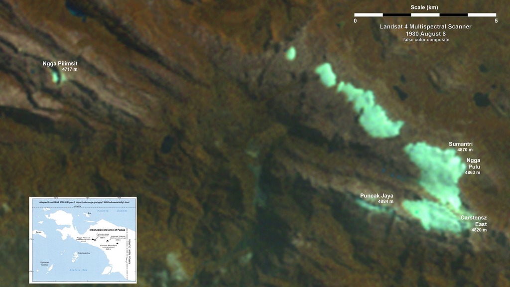
Nine Landsat images from 1980 to 2018 show the progressive loss of ice from the highest part of the Surdiman Range, part of the Maoke ‘Snow’ Mountains in the Indonesian Province of Papua on the island of New Guinea. This location is ~4 degrees south of the Equator but the rocky peaks near Puncak Jaya (4884 m) have had extensive glacial ice cover for thousands of years. Other researchers (Hope et al., 1976; Klein and Kincaid, 2006) have previously documented glacial retreat and the progressive loss of ice cover in this region.
This time series of false-color multispectral images includes an initial Landsat 2 Multispectral Scanner (MSS) image from 1980 as well as an MSS from Landsat 4. These are followed by Landsat 5 Thematic Mapper images (TM) in 1988 and 1993, a Landsat 7 Enhanced Thematic Mapper Plus image from 1999, two more Landsat 5 TM images in 2004 and 2009, and the series concludes with Landsat 8 Operational Land Imager scenes in 2015 and 2018. Excluding the small ice area near Ngga Pilimsit, from an initial ice area of ~6.3 km2 in 1980 near the highest peaks east of the vast Grasberg Mine, less than 0.5 km2 of glacial ice remains.
Ice Losses in Tropical Asia
This time series of false-color multispectral images includes an initial Landsat 2 Multispectral Scanner (MSS) image from 1980 as well as an MSS from Landsat 4. These are followed by Landsat 5 Thematic Mapper images (TM) in 1988 and 1993, a Landsat 7 Enhanced Thematic Mapper Plus image from 1999, two more Landsat 5 TM images in 2004 and 2009, and the series concludes with Landsat 8 Operational Land Imager scenes in 2015 and 2018. Excluding the small ice area near Ngga Pilimsit, from an initial ice area of ~6.3 km2 in 1980 near the highest peaks east of the vast Grasberg Mine, less than 0.5 km2 of glacial ice remains.
Credits
Amy Moran (Global Science and Technology, Inc.): Lead Animator
Christopher Shuman (UMBC JCET): Lead Scientist
Christopher Shuman (UMBC JCET): Lead Scientist
Please give credit for this item to:
NASA's Goddard Space Flight Center
NASA's Goddard Space Flight Center
Short URL to share this page:
https://svs.gsfc.nasa.gov/30938
Mission:
Landsat
This item is part of this series:
Landsat
Keywords:
SVS >> HDTV
SVS >> Landsat
GCMD >> Location >> Papua New Guinea
SVS >> Hyperwall
SVS >> Glaciers
NASA Science >> Earth
GCMD keywords can be found on the Internet with the following citation: Olsen, L.M., G. Major, K. Shein, J. Scialdone, S. Ritz, T. Stevens, M. Morahan, A. Aleman, R. Vogel, S. Leicester, H. Weir, M. Meaux, S. Grebas, C.Solomon, M. Holland, T. Northcutt, R. A. Restrepo, R. Bilodeau, 2013. NASA/Global Change Master Directory (GCMD) Earth Science Keywords. Version 8.0.0.0.0


