Earth
ID: 30496
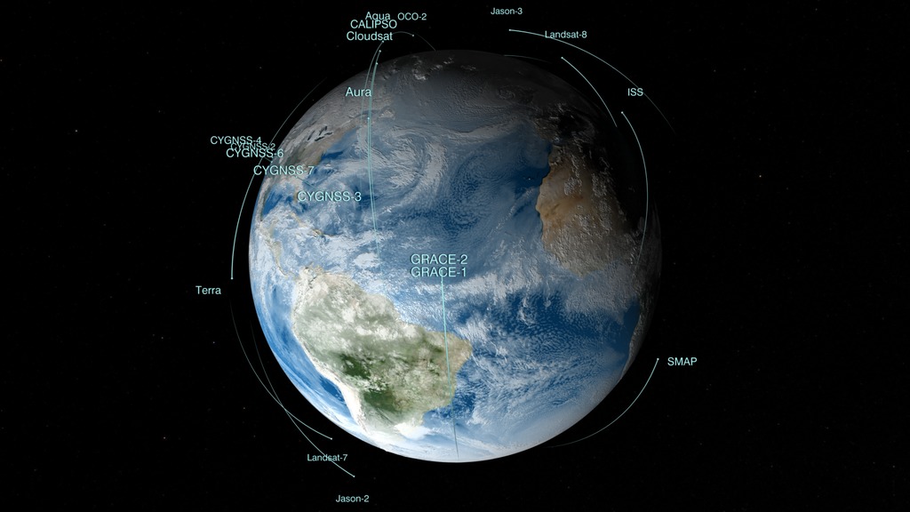
Like orbiting sentinels, NASA’s Earth-observing satellites vigilantly monitor our planet’s ever-changing pulse from their unique vantage points in orbit. This animation shows the orbits of all of the current satellite missions. The flight paths are based on actual orbital elements. These missions—many joint with other nations and/or agencies—are able to collect global measurements of rainfall, solar irradiance, clouds, sea surface height, ocean salinity, and other aspects of the environment. Together, these measurements help scientists better diagnose the “health” of the Earth system.
Earth Observing Fleet
This animation will be regularly updated to show the orbits of the current earth observing fleet.
This most recent version, published in March 2017, includes the CYGNSS constellation and DSCOVR at L1. Visit the original page here.
Previous versions from recent years include:
entry 4274 a February 2015 version including SMAP
entry 3996 a spring 2014 version including GPM
entry 4070 a May 2013 version which added Landsat-8
entry 3892 a Dec 2011 version which added Suomi NPP and Aquarius
entry 3725 a version from June 2010
Related

Credits
Greg Shirah (NASA/GSFC): Lead Animator
Ernie Wright (USRA): Animator
Alex Kekesi (Global Science and Technology, Inc.): Animator
Eric Sokolowsky (Global Science and Technology, Inc.): Animator
Laurence Schuler (ADNET Systems, Inc.): Project Support
Ian Jones (ADNET Systems, Inc.): Project Support
Ernie Wright (USRA): Animator
Alex Kekesi (Global Science and Technology, Inc.): Animator
Eric Sokolowsky (Global Science and Technology, Inc.): Animator
Laurence Schuler (ADNET Systems, Inc.): Project Support
Ian Jones (ADNET Systems, Inc.): Project Support
Please give credit for this item to:
NASA's Scientific Visualization Studio
NASA's Scientific Visualization Studio
Short URL to share this page:
https://svs.gsfc.nasa.gov/30496
Missions:
Aqua
Aquarius
Aura
CALIPSO
Cloudsat
Earth Observing-1
Gravity Recovery and Climate Experiment (GRACE)
Landsat
LDCM: Landsat Data Continuity Mission
Orbiting Carbon Observatory 2 (OCO-2)
Suomi NPP
Terra
Soil Moisture Active Passive (SMAP)
ISS-RapidScat
Cyclone Global Navigation Satellite System (CYGNSS)
Deep Space Climate Observatory (DSCOVR)
Data Used:
Note: While we identify the data sets used in these visualizations, we do not store any further details nor the data sets themselves on our site.
Keywords:
DLESE >> Atmospheric science
SVS >> HDTV
SVS >> Landsat
SVS >> Simulation
SVS >> Spacecraft
GCMD >> Earth Science >> Atmosphere
GCMD >> Earth Science >> Atmosphere >> Clouds
SVS >> Orbit
SVS >> Hyperwall
SVS >> Aquarius
SVS >> Calipso
SVS >> Cloudsat
SVS >> Aura
SVS >> GRACE
SVS >> NPP
SVS >> LDCM
SVS >> Earth >> Satellites >> Earth Observing Fleet
NASA Science >> Earth
SVS >> DSCOVR
SVS >> CYGNSS
GCMD keywords can be found on the Internet with the following citation: Olsen, L.M., G. Major, K. Shein, J. Scialdone, S. Ritz, T. Stevens, M. Morahan, A. Aleman, R. Vogel, S. Leicester, H. Weir, M. Meaux, S. Grebas, C.Solomon, M. Holland, T. Northcutt, R. A. Restrepo, R. Bilodeau, 2013. NASA/Global Change Master Directory (GCMD) Earth Science Keywords. Version 8.0.0.0.0
https://svs.gsfc.nasa.gov/30496
Missions:
Aqua
Aquarius
Aura
CALIPSO
Cloudsat
Earth Observing-1
Gravity Recovery and Climate Experiment (GRACE)
Landsat
LDCM: Landsat Data Continuity Mission
Orbiting Carbon Observatory 2 (OCO-2)
Suomi NPP
Terra
Soil Moisture Active Passive (SMAP)
ISS-RapidScat
Cyclone Global Navigation Satellite System (CYGNSS)
Deep Space Climate Observatory (DSCOVR)
Data Used:
CelesTrak Spacecraft Orbit Ephemeris
EphemerisTerra and Aqua/MODIS/Blue Marble: Next Generation also referred to as: BMNG
Credit:
The Blue Marble data is courtesy of Reto Stockli (NASA/GSFC).
The Blue Marble data is courtesy of Reto Stockli (NASA/GSFC).
GEOS-5 Atmospheric Model on the Cubed-Sphere also referred to as: GEOS-5 Cubed-Sphere
Model - NASA GMAO
The model is the GEOS-5 atmospheric model on the cubed-sphere, run at 14-km global resolution for 30-days. GEOS-5 is described here http://gmao.gsfc.nasa.gov/systems/geos5/ and the cubed-sphere work is described here http://sivo.gsfc.nasa.gov/cubedsphere_overview.html.
Keywords:
DLESE >> Atmospheric science
SVS >> HDTV
SVS >> Landsat
SVS >> Simulation
SVS >> Spacecraft
GCMD >> Earth Science >> Atmosphere
GCMD >> Earth Science >> Atmosphere >> Clouds
SVS >> Orbit
SVS >> Hyperwall
SVS >> Aquarius
SVS >> Calipso
SVS >> Cloudsat
SVS >> Aura
SVS >> GRACE
SVS >> NPP
SVS >> LDCM
SVS >> Earth >> Satellites >> Earth Observing Fleet
NASA Science >> Earth
SVS >> DSCOVR
SVS >> CYGNSS
GCMD keywords can be found on the Internet with the following citation: Olsen, L.M., G. Major, K. Shein, J. Scialdone, S. Ritz, T. Stevens, M. Morahan, A. Aleman, R. Vogel, S. Leicester, H. Weir, M. Meaux, S. Grebas, C.Solomon, M. Holland, T. Northcutt, R. A. Restrepo, R. Bilodeau, 2013. NASA/Global Change Master Directory (GCMD) Earth Science Keywords. Version 8.0.0.0.0


