Earth
ID: 30289
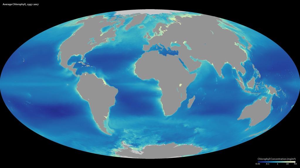
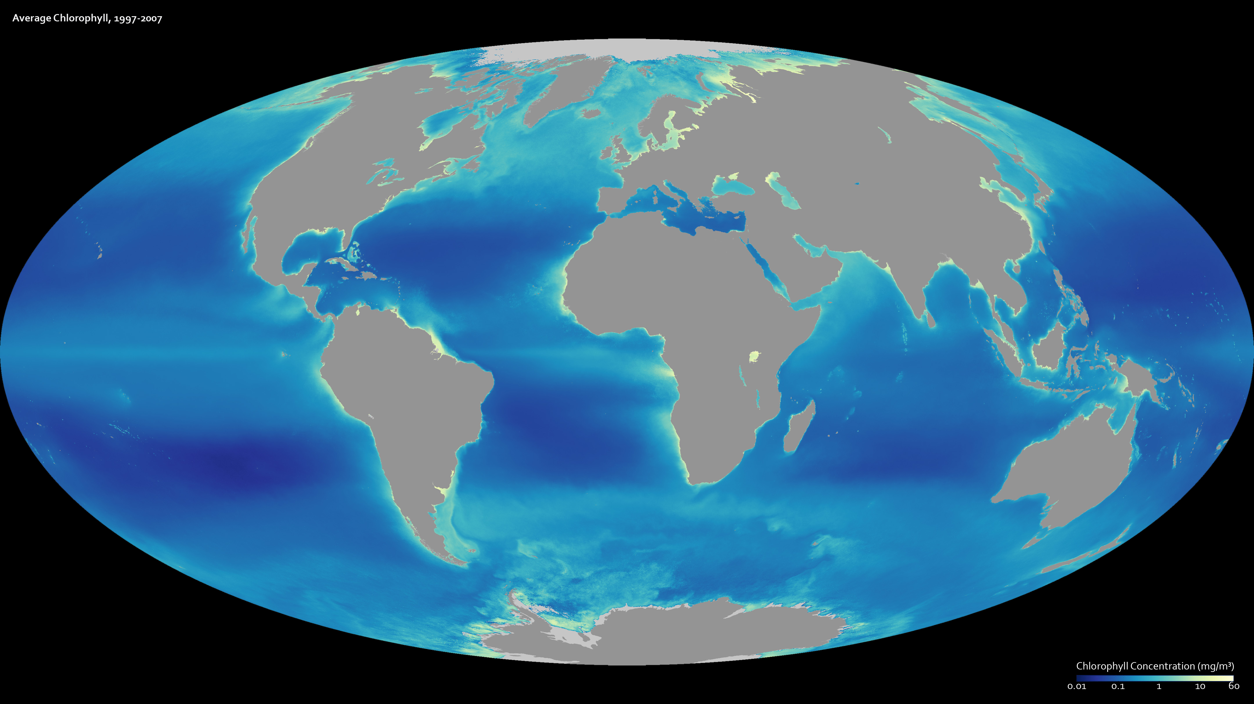
A decade of observations from the SeaWiFS satellite are represented in this image, which shows average chlorophyll concentrations in Earth’s oceans from mid-September 1997 through the end of August 2007. Areas where plants thrive are light blue and yellow, while less productive regions are dark blue. The satellite records the amount of light that chlorophyll is soaking up as the plant converts light, water, and carbon dioxide into glucose and oxygen through photosynthesis. In general, high chlorophyll corresponds with a high number of healthy plants. The global relationship between temperature and productivity was one that scientists first observed in SeaWiFS data. The places with the lowest chlorophyll concentrations are in the tropics, while the cold waters in the Arctic and Antarctic have high chlorophyll concentrations. What the image does not show is that the growth at the poles is seasonal. The plants only flourish during the spring and summer when there is sufficient light to fuel photosynthesis.
A Decade of Ocean Color
Alternate Version
For More Information
Credits
Please give credit for this item to:
NASA/Goddard Space Flight Center, The SeaWiFS Project and GeoEye. NOTE: All SeaWiFS images and data presented on this web site are for research and educational use only. All commercial use of SeaWiFS data must be coordinated with GeoEye (NOTE: In January 2013, DigitalGlobe and GeoEye combined to become DigitalGlobe).
NASA/Goddard Space Flight Center, The SeaWiFS Project and GeoEye. NOTE: All SeaWiFS images and data presented on this web site are for research and educational use only. All commercial use of SeaWiFS data must be coordinated with GeoEye (NOTE: In January 2013, DigitalGlobe and GeoEye combined to become DigitalGlobe).
Short URL to share this page:
https://svs.gsfc.nasa.gov/30289
Data Used:
Note: While we identify the data sets used in these visualizations, we do not store any further details nor the data sets themselves on our site.
Keywords:
DLESE >> Physical oceanography
GCMD >> Earth Science >> Oceans >> Marine Biology >> Marine Microbiota
GCMD >> Earth Science >> Oceans >> Ocean Optics >> Ocean Color
SVS >> Hyperwall
NASA Science >> Earth
SVS >> Presentation
GCMD keywords can be found on the Internet with the following citation: Olsen, L.M., G. Major, K. Shein, J. Scialdone, S. Ritz, T. Stevens, M. Morahan, A. Aleman, R. Vogel, S. Leicester, H. Weir, M. Meaux, S. Grebas, C.Solomon, M. Holland, T. Northcutt, R. A. Restrepo, R. Bilodeau, 2013. NASA/Global Change Master Directory (GCMD) Earth Science Keywords. Version 8.0.0.0.0
https://svs.gsfc.nasa.gov/30289
Data Used:
SeaStar/SeaWiFS/Chlorophyll Concentration
1997-2007
All SeaWiFS images and data presented on this web site are for research and educational use only. All commercial use of SeaWiFS data must be coordinated with GeoEye.
Credit:
NASA/Goddard Space Flight Center, The SeaWiFS Project and GeoEye, Scientific Visualization Studio. NOTE: All SeaWiFS images and data presented on this web site are for research and educational use only. All commercial use of SeaWiFS data must be coordinated with GeoEye (NOTE: In January 2013, DigitalGlobe and GeoEye combined to become one DigitalGlobe.).
NASA/Goddard Space Flight Center, The SeaWiFS Project and GeoEye, Scientific Visualization Studio. NOTE: All SeaWiFS images and data presented on this web site are for research and educational use only. All commercial use of SeaWiFS data must be coordinated with GeoEye (NOTE: In January 2013, DigitalGlobe and GeoEye combined to become one DigitalGlobe.).
Keywords:
DLESE >> Physical oceanography
GCMD >> Earth Science >> Oceans >> Marine Biology >> Marine Microbiota
GCMD >> Earth Science >> Oceans >> Ocean Optics >> Ocean Color
SVS >> Hyperwall
NASA Science >> Earth
SVS >> Presentation
GCMD keywords can be found on the Internet with the following citation: Olsen, L.M., G. Major, K. Shein, J. Scialdone, S. Ritz, T. Stevens, M. Morahan, A. Aleman, R. Vogel, S. Leicester, H. Weir, M. Meaux, S. Grebas, C.Solomon, M. Holland, T. Northcutt, R. A. Restrepo, R. Bilodeau, 2013. NASA/Global Change Master Directory (GCMD) Earth Science Keywords. Version 8.0.0.0.0


