Earth
ID: 30162
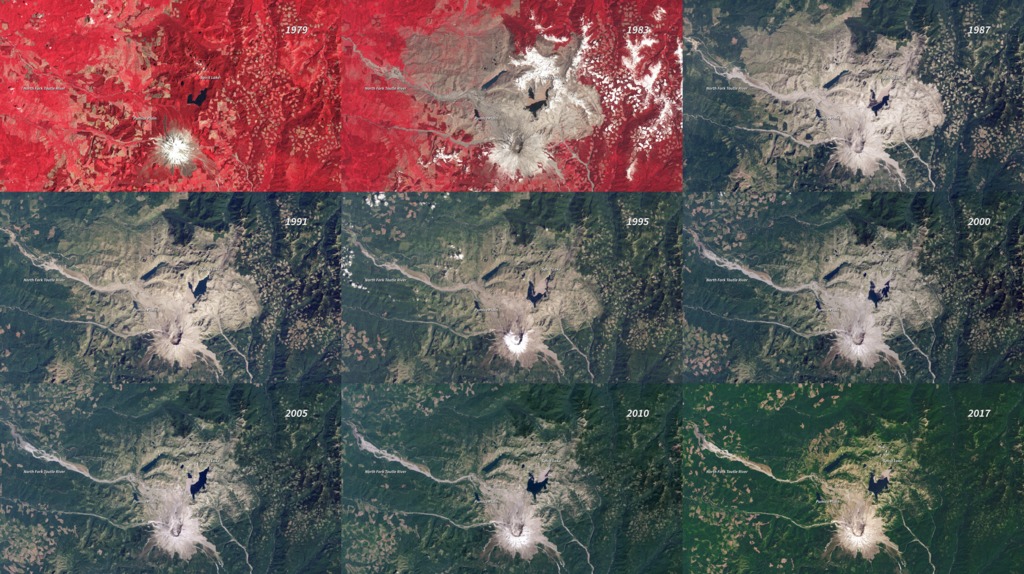
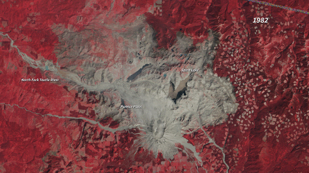
In the nearly four decades since the eruption (1980), Mt. St. Helens has given scientists an unprecedented opportunity to witness the steps through which life reclaims a devastated landscape. The scale of the eruption and the beginning of reclamation in the Mt. St. Helens blast zone are documented in this series of images between 1979 and 2017. The older images are false-color (vegetation is red). Not surprisingly, the first noticeable recovery (late 1980s) takes place in the northwestern quadrant of the blast zone, farthest from the volcano. It is another decade (late 1990s) before the terrain east of Spirit Lake is considerably greener. By the end of the series, the only area (beyond the slopes of the mountain itself) that remains conspicuously bare at the scale of these images is the Pumice Plain.
Devastation and Recovery of Mt. St. Helens
For More Information
Credits
Amy Moran (Global Science and Technology, Inc.): Animator
Please give credit for this item to:
NASA/Goddard Space Flight Center
NASA/Goddard Space Flight Center
Short URL to share this page:
https://svs.gsfc.nasa.gov/30162
Missions:
Landsat
LDCM: Landsat Data Continuity Mission
Data Used:
Note: While we identify the data sets used in these visualizations, we do not store any further details nor the data sets themselves on our site.
This item is part of this series:
World of Change
Keywords:
DLESE >> Forestry
SVS >> HDTV
DLESE >> Human geography
SVS >> Mt. St. Helens
DLESE >> Physical geography
SVS >> Volcano
GCMD >> Earth Science >> Land Surface >> Landscape >> Reclamation/Revegetation/Restoration
GCMD >> Earth Science >> Land Surface >> Landscape >> Reforestation
SVS >> Hyperwall
NASA Science >> Earth
SVS >> Presentation
GCMD keywords can be found on the Internet with the following citation: Olsen, L.M., G. Major, K. Shein, J. Scialdone, S. Ritz, T. Stevens, M. Morahan, A. Aleman, R. Vogel, S. Leicester, H. Weir, M. Meaux, S. Grebas, C.Solomon, M. Holland, T. Northcutt, R. A. Restrepo, R. Bilodeau, 2013. NASA/Global Change Master Directory (GCMD) Earth Science Keywords. Version 8.0.0.0.0
https://svs.gsfc.nasa.gov/30162
Missions:
Landsat
LDCM: Landsat Data Continuity Mission
Data Used:
Landsat/TM, ETM, ETM+/Band Combination 1, 2, 3
1979-2014This item is part of this series:
World of Change
Keywords:
DLESE >> Forestry
SVS >> HDTV
DLESE >> Human geography
SVS >> Mt. St. Helens
DLESE >> Physical geography
SVS >> Volcano
GCMD >> Earth Science >> Land Surface >> Landscape >> Reclamation/Revegetation/Restoration
GCMD >> Earth Science >> Land Surface >> Landscape >> Reforestation
SVS >> Hyperwall
NASA Science >> Earth
SVS >> Presentation
GCMD keywords can be found on the Internet with the following citation: Olsen, L.M., G. Major, K. Shein, J. Scialdone, S. Ritz, T. Stevens, M. Morahan, A. Aleman, R. Vogel, S. Leicester, H. Weir, M. Meaux, S. Grebas, C.Solomon, M. Holland, T. Northcutt, R. A. Restrepo, R. Bilodeau, 2013. NASA/Global Change Master Directory (GCMD) Earth Science Keywords. Version 8.0.0.0.0


