Earth
ID: 2410
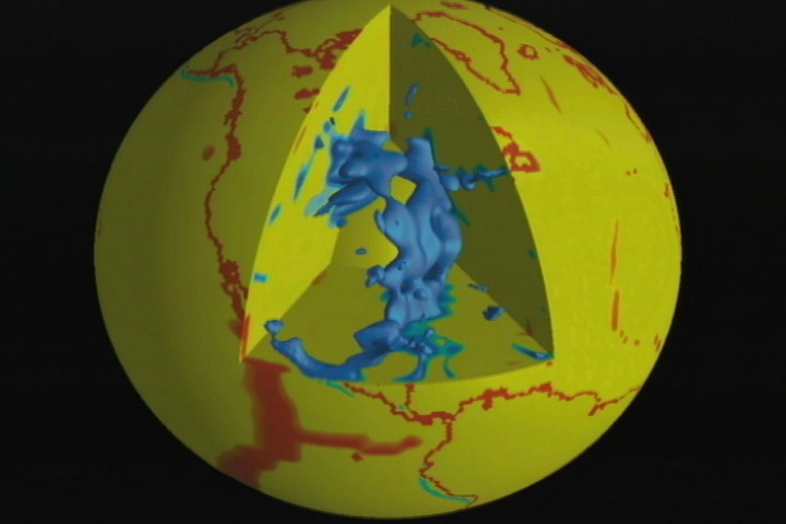
The Rockies are fifteen hundred kilometers, or one thousand miles, to the east. The cause must be the tectonic plate that built these mountains. Its name is Farallon. Farallon started off normally enough. It plunged beneath the North American Plate at a forty-five degree angle. This process sprouted volcanoes to form the Sierra Nevada in what is now California.
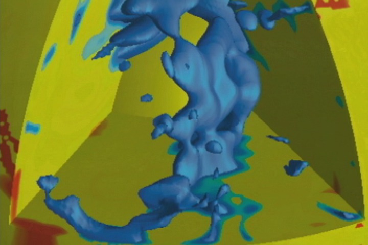
Next, mantle motions pulled North America westward over Farallon, and the plate scraped along the bottom of the continent - for fifteen hundred kilometers. As North America continued its westward trek, Farallon settled to the bottom of the mantle.
The image is output from a model run using the TERRA mantle software. To learn more about Bunge's work, visit his web site at: http://www.geophysik.uni-muenchen.de/Members/bunge.
Farallon Plate Remnants
Next, mantle motions pulled North America westward over Farallon, and the plate scraped along the bottom of the continent - for fifteen hundred kilometers. As North America continued its westward trek, Farallon settled to the bottom of the mantle.
The image is output from a model run using the TERRA mantle software. To learn more about Bunge's work, visit his web site at: http://www.geophysik.uni-muenchen.de/Members/bunge.
Visualization Credits
Please give credit for this item to:
NASA/Goddard Space Flight Center Scientific Visualization Studio
NASA/Goddard Space Flight Center Scientific Visualization Studio
Short URL to share this page:
https://svs.gsfc.nasa.gov/2410
Data Used:
Note: While we identify the data sets used in these visualizations, we do not store any further details nor the data sets themselves on our site.
Keywords:
SVS >> Farallon Plate
DLESE >> Geologic time
DLESE >> Geophysics
DLESE >> Physical geography
DLESE >> Structural geology
NASA Science >> Earth
https://svs.gsfc.nasa.gov/2410
Data Used:
TERRA software
Keywords:
SVS >> Farallon Plate
DLESE >> Geologic time
DLESE >> Geophysics
DLESE >> Physical geography
DLESE >> Structural geology
NASA Science >> Earth


