Earth
ID: 13242
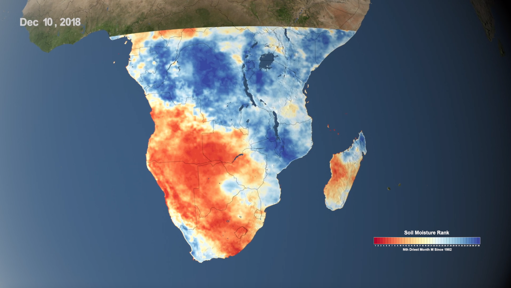
NASA’s satellite imagery and model forecasts play an important role in monitoring the performance of crops worldwide and preparing for food shortages. NASA's view from space helps government agencies forecast food insecurity, like during the drought in Southern Africa in 2018.
Using NASA Data to Monitor Drought and Food Insecurity
Related
Credits
Kathryn Mersmann (USRA): Lead Producer
Maria-Jose Vinas Garcia (Telophase): Lead Writer
Ellen T. Gray (ADNET Systems, Inc.): Producer
Trent L. Schindler (USRA): Lead Visualizer
Christa Peters-Lidard (NASA/GSFC): Scientist
John D. Bolten (NASA/GSFC): Scientist
Amy McNally (SAIC): Scientist
Maria-Jose Vinas Garcia (Telophase): Lead Writer
Ellen T. Gray (ADNET Systems, Inc.): Producer
Trent L. Schindler (USRA): Lead Visualizer
Christa Peters-Lidard (NASA/GSFC): Scientist
John D. Bolten (NASA/GSFC): Scientist
Amy McNally (SAIC): Scientist
Please give credit for this item to:
NASA's Goddard Space Flight Center
NASA's Goddard Space Flight Center
Short URL to share this page:
https://svs.gsfc.nasa.gov/13242
This item is part of this series:
Narrated Movies
Keywords:
SVS >> Drought
SVS >> HDTV
GCMD >> Earth Science >> Climate Indicators >> Drought Indices
NASA Science >> Earth
GCMD >> Earth Science >> Human Dimensions >> Natural Hazards >> Famine
SVS >> Freshwater
GCMD keywords can be found on the Internet with the following citation: Olsen, L.M., G. Major, K. Shein, J. Scialdone, S. Ritz, T. Stevens, M. Morahan, A. Aleman, R. Vogel, S. Leicester, H. Weir, M. Meaux, S. Grebas, C.Solomon, M. Holland, T. Northcutt, R. A. Restrepo, R. Bilodeau, 2013. NASA/Global Change Master Directory (GCMD) Earth Science Keywords. Version 8.0.0.0.0


