Presentation by Helen-Nicole Kostis
Visuals
- ID: 3578 Visualization
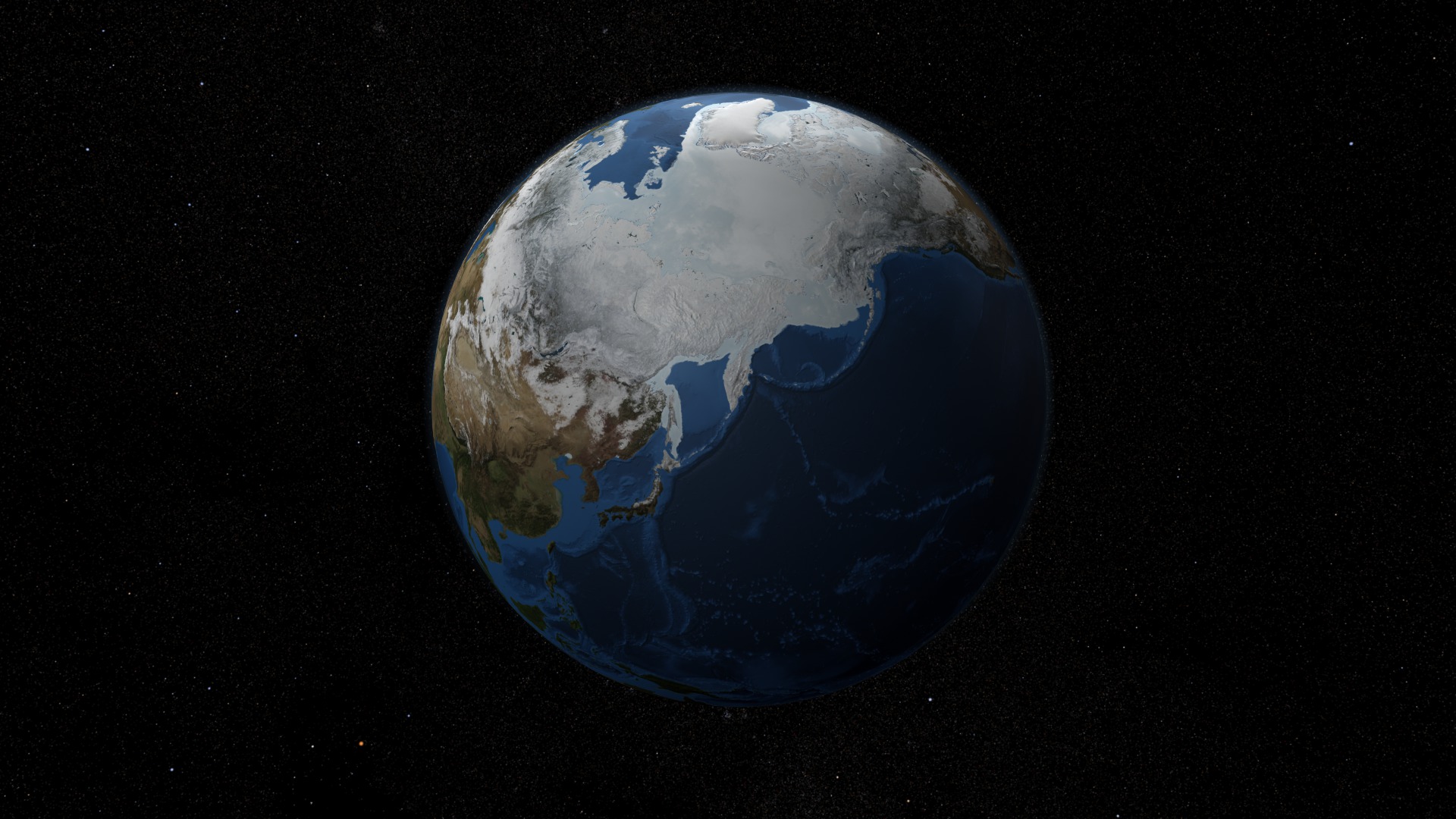
AMSR-E Arctic Sea Ice: 2005 to 2008 - Stereoscopic Version
Go to this pageSea ice is frozen seawater floating on the surface of the ocean. Some sea ice is semi-permanent, persisting from year to year, and some is seasonal, melting and refreezing from season to season. The sea ice cover reaches its minimum extent at the end of each summer and the remaining ice is called the perennial ice cover.In this animation, the globe slowly rotates one full rotation while the Arctic sea ice and seasonal land cover change throughout the years. The animation begins on September 21, 2005 when sea ice in the Arctic was at its minimum extent, and continues through September 20, 2008. This time period repeats twice during the animation, playing at a rate of one frame per day. Over the terrain, monthly data from the seasonal Blue Marble Next Generation fades slowly from month to month. Over the water, Arctic sea ice changes from day to day. This visualization is a stereoscopic version of animation entry: #3571: AMSR-E Arctic Sea Ice: 2005 to 2008In this page the visualization content is offered in two different modes to accomodate stereoscopic systems, such as: Left and Right Eye separate and Left and Right Eye side-by-side combined on the same frame. ||
- ID: 3585 Visualization
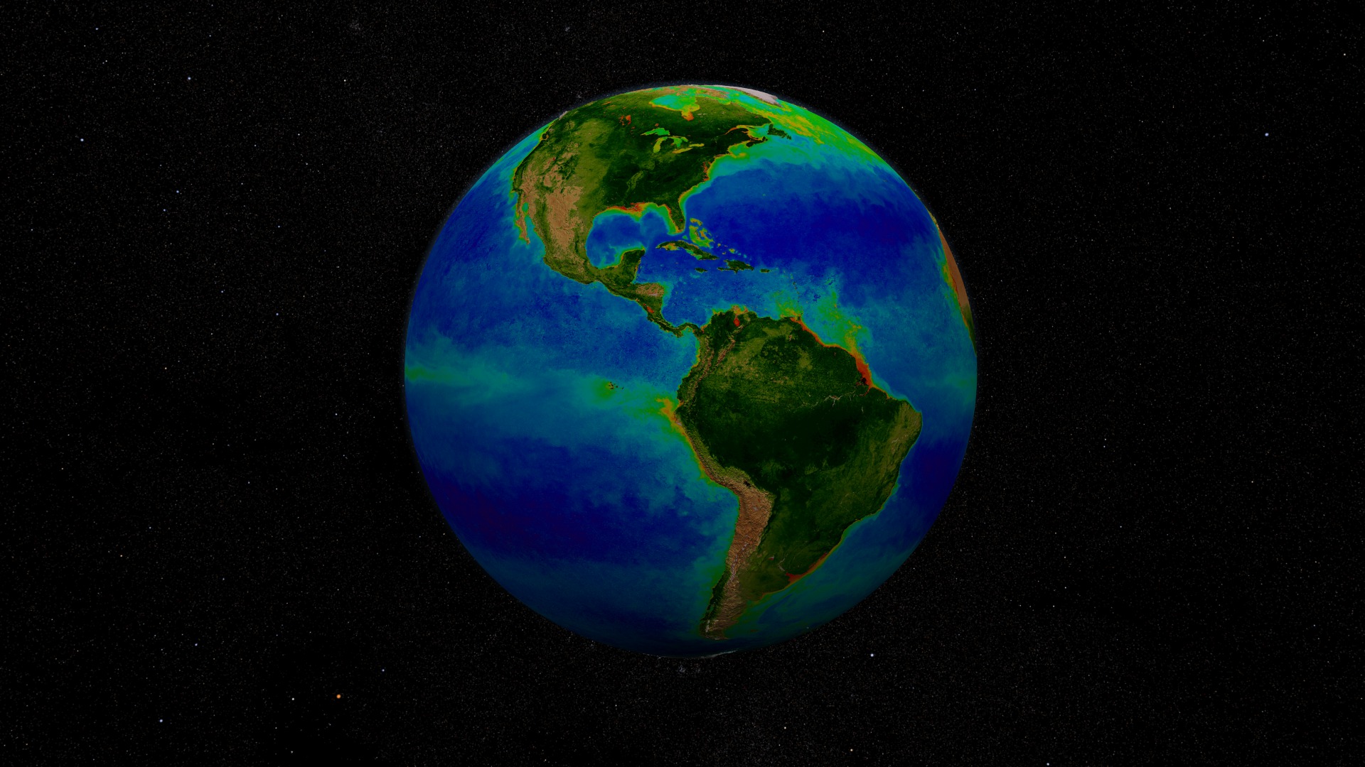
Stereoscopic SeaWiFS Biosphere Global Rotation: 1997-2006
Go to this pageThe SeaWiFS instrument aboard the SeaStar satellite has been collecting ocean data since 1997. By monitoring the color of reflected light via satellite, scientists can determine how successfully plant life is photosynthesizing. A measurement of photosynthesis is essentially a measurement of successful growth, and growth means successful use of ambient carbon.This animation represents nearly a decade's worth of data taken by the SeaWiFS instrument, showing the abundance of life in the sea. This time period repeats twice during the animation. Dark blue represents warmer areas where there is little life due to lack of nutrients, and greens and reds represent cooler nutrient-rich areas. The nutrient-rich areas include coastal regions where cold water rises from the sea floor bringing nutrients along and areas at the mouths of rivers where the rivers have brought nutrients into the ocean from the land. The nutrient-rich waters contribute to some of the oxygen-poor pockets of the seas called dead zones.This visualization is a stereoscopic version of animation entry: #3420:SeaWiFS Biosphere Global Rotation from 1997 to 2006 ||
- ID: 3587 Visualization
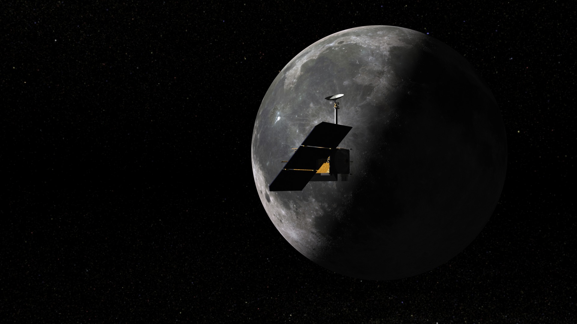
LRO Scouts for Safe Landing Sites - Stereoscopic Version
Go to this pageThe Lunar Reconnaissance Orbiter (LRO) is NASA's scouting mission to prepare for a return to the moon. One of its primary objectives will be to assess the lunar terrain for areas that would provide safe landing sites for future missions, both manned and unmanned, that plan to touch down on the moon's surface. This video helps explain how LRO will accomplish its objective.This visualization is a modified 3D stereo version of animation entry:#10349: LRO Scouts for Safe Landing Sites.The raw stereoscopic visualization sequence used to create this narrated animation can be viewed and downloaded from entry: #3567: How LRO Will Find Safe Landing Sites on the Moon - Stereoscopic Version. ||
- ID: 3603 Visualization
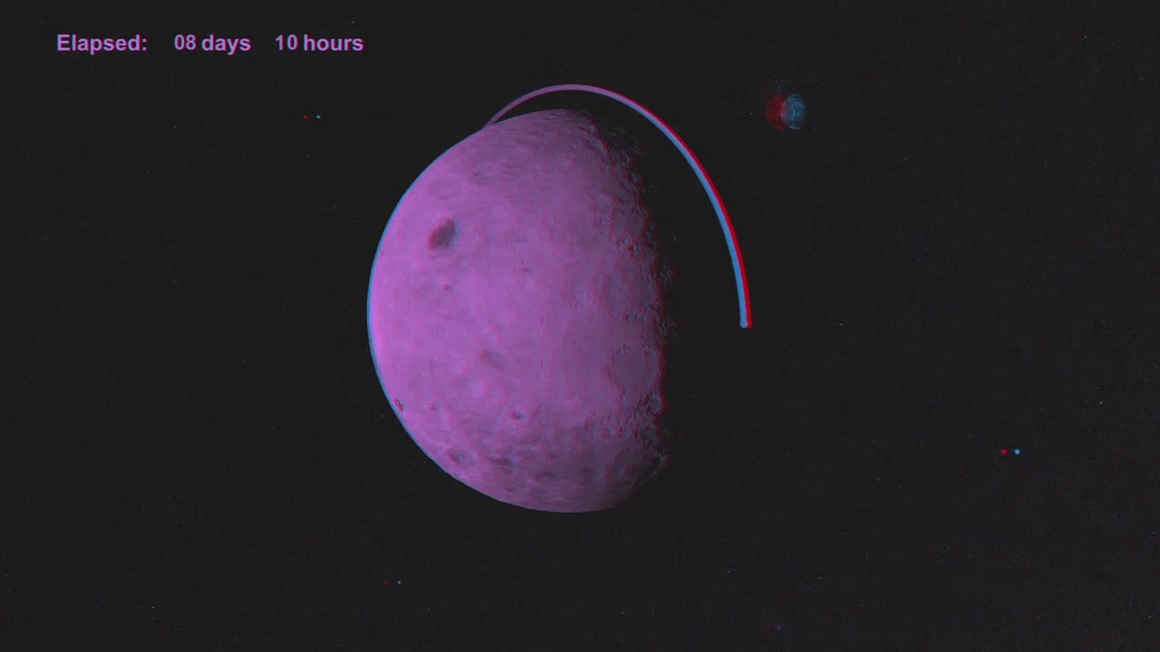
Lunar Reconnaissance Orbiter (LRO) Orbit Insertion - Stereoscopic Version
Go to this pageThis visualization shows an example of how the orbit insertion for the Lunar Reconnaissance Orbiter (LRO) might look. LRO launches from Cape Canaveral, then flies around the Earth and on to the moon. Time speeds up during the journey to the moon, then slows again as LRO approaches the moon. LRO begins orbiting the moon and, through a series of several "burns", moves in closer to its desired orbit. LRO's initial orbit plane around the moon is parallel to the direction of the moon's travel.This visualization was created before launch using simulated ephemeris data. The ephemeris data driving this visualization was based on a simulated night time launch on 11/24/2008; but, the actual launch may happen during the daytime. In this page the visualization content is offered in two different modes to accomodate stereoscopic systems as: Left and Right Eye separate and Left and Right Eye side-by-side combined on the same frame. ||
- ID: 3529 Visualization
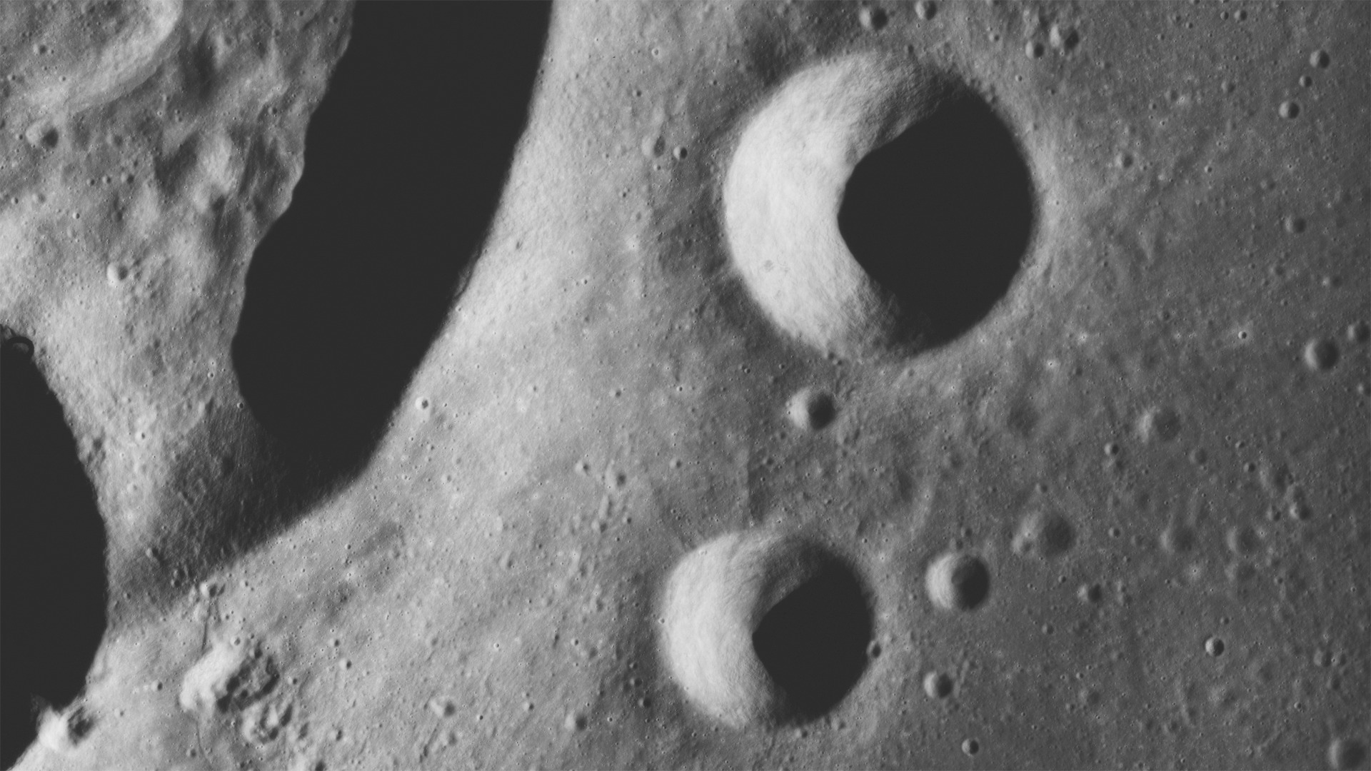
Apollo 15 Rectified Stereo Stills: KRIEGER
Go to this pageThis entry offers a set of stereoscopic images of the lunar suface captured during the Apollo mission 15. The images feature craters: Krieger, Rocco and Ruth and their surrounding areas. Imagery is offered in various modes, such as: left and right stereo stills, with and without captions and scale information, and 3D anaglyphs. For related entries and more information, please visit: #3530: Apollo 15 Rectified Anaglyph Stereo Panorama #3531: Apollo 15 Rectified Stereo Panorama - Left and Right Eye imagery Data Notes:August 4, 1971 The lunar stereo still imagery provided in this page used as source material archived panoramic recitifed film photographs. Nearly all the panoramic photographs from the Apollo 15, 16 and 17 missions have been rectified and are archived in the NASA/GSFC campus. The rectification process corrected the camera and viewing distortions, as it results in a vertical projection of the lunar surface.The rectified photographs are more accurate for stereoscopic use than the original panoramic photographs. Detailed information is provided below:Image Collection: Panoramic Mission: 15Magazine: PCamera: 610-mm (24-in.) ITEK panoramic cameraRevolution: 72Latitude/Longitude: 29° N/ 45°W Lens Focal Length: 24 inchStereo Pairs:AS15-P-10320 (Forward Camera Look), AS15-P-10325 (After Camera Look)Camera Altitude: 109 kmSun Elevation: 20°Film type: 3414Film Width: 5 inchImage Width: 45.24 inch Image Height: 4.5 inch Film Color: black and whiteFeatures: Craters Krieger, Rocco, RuthLow resolution lunar stereo imagery can be found at the Apollo Image Atlas Panoramic Catalog hosted by the Lunar and Planetary Institute.For a detailed index map of panoramic camera photographs, composite of all REVs, please visit: http://www.lpi.usra.edu/resources/mapcatalog/apolloindex/apollo15/as15indexmap01/ ||