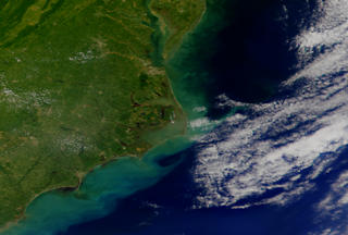
Carolina Coast from SeaWiFS: October 26, 1999
Viewing the Cape Hatteras Pamlico Sound area with SeaStar satellite.

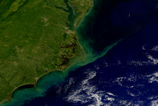
The Carolina coast on October 16, 1999 from SeaWiFS
For More Information
Credits
Please give credit for this item to:
NASA/Goddard Space Flight Center, The SeaWiFS Project and GeoEye, Scientific Visualization Studio. NOTE: All SeaWiFS images and data presented on this web site are for research and educational use only. All commercial use of SeaWiFS data must be coordinated with GeoEye (NOTE: In January 2013, DigitalGlobe and GeoEye combined to become DigitalGlobe).
-
Animator
- Stuart A. Snodgrass (Global Science and Technology, Inc.)
-
Scientist
- Gene Feldman (NASA/GSFC)
Series
This page can be found in the following series:Datasets used
-
True Color [SeaStar: SeaWiFS]
ID: 473All SeaWiFS images and data presented on this web site are for research and educational use only. All commercial use of SeaWiFS data must be coordinated with GeoEye.
Credit: NASA/Goddard Space Flight Center, The SeaWiFS Project and GeoEye, Scientific Visualization Studio. NOTE: All SeaWiFS images and data presented on this web site are for research and educational use only. All commercial use of SeaWiFS data must be coordinated with GeoEye (NOTE: In January 2013, DigitalGlobe and GeoEye combined to become one DigitalGlobe.).
This dataset can be found at: http://oceancolor.gsfc.nasa.gov/PRODUCTS/
See all pages that use this dataset
Note: While we identify the data sets used on this page, we do not store any further details, nor the data sets themselves on our site.
Related
- ID: 739
 Visualization
 - ID: 740
 Visualization
Release date
This page was originally published on Wednesday, October 27, 1999.
This page was last updated on Wednesday, May 3, 2023 at 1:58 PM EDT.