August 27-28, 2026 Deep Partial Lunar Eclipse
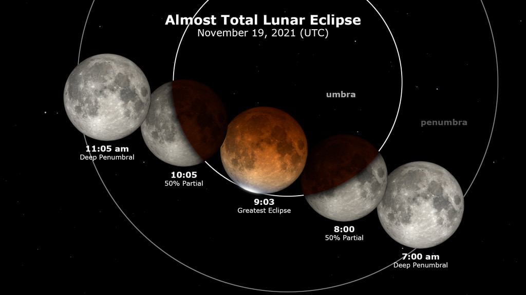
The Moon moves right to left through Earth's penumbra and umbra shadows. At various times, a copy of the Moon is left behind along with its associated UTC time, and this forms a lunar eclipse diagram showing different stages of the eclipse.
On August 28, 2026 (the evening of the 27th in some time zones), the Moon passes into the shadow of Earth, creating a deep partial eclipse. At the moment of greatest eclipse, 4:13 a.m. Universal Time, 96.3% of the Moon's disk is within Earth's umbra, the central part of the shadow where the Sun is completely blocked by Earth. This part of the eclipse is visible in the Americas (except Alaska and northwestern Canada), western Europe and western Africa.
The penumbra is the part of Earth's shadow where the Sun is only partially covered by Earth. The effect of the penumbra on the Moon's appearance is subtle. But after the partial phase begins, at 2:34 UTC (10:34 p.m. Eastern on the night of the 27th), the umbra's dramatic effect is easily visible as it takes an increasingly large bite out of the disk of the full Moon. Less than an hour later, the part of the Moon still in sunlight will be small enough for observers' eyes to adapt to darkness and perceive the coppery color of the part of the Moon within the umbra. The visualizations here mimic this dark adaptation by increasing the apparent photographic exposure around the time of greatest eclipse.
This eclipse is a member of Saros 138. The eclipses in a given saros series are separated by 18 years, 11 days, 8 hours. The previous eclipse in this saros series occurred on August 16, 2008, and the next takes place on September 7, 2044.
Obscuration Versus Magnitude
Two measures are used to describe how much of the Moon is within the umbra shadow at the height of a lunar eclipse. Umbra magnitude, the value found for example on Fred Espenak's NASA eclipse site, is the fraction of the diameter of the Moon covered by the umbra, while obscuration (the 96.3% number here) is the area covered by the umbra.
Magnitude is easier to calculate and can tell you something extra about the nature of an eclipse. Eclipse magnitude can be greater than 1.0 or less than 0.0. Values greater than 1.0 indicate the depth and duration of totality by measuring how close the Moon gets to the center of the umbra. Negative magnitudes denote penumbral eclipses, when the Moon misses the umbra entirely. In natural language, the magnitude of a partial lunar eclipse should be qualified by saying something like "93% of the width of the Moon" will be within the umbra. For total and penumbral eclipses, such as the June 2029 total lunar eclipse at magnitude 1.84, this phrasing can't express what the number means.
Obscuration is more intuitive — it's always between 0 and 1 — and it more closely matches the visual experience. You can say without qualification that "96.3% of the Moon's disk" will be within the umbra.

A still image of the eclipse diagram.
A world map showing where the eclipse is visible at different phases. Contours mark the boundary around the part of Earth where each phase is visible. The start of the partial phase, for example, is visible everywhere within the orange contour. The map is centered on 63°8'W, the sublunar point at greatest eclipse (the longitude where the Moon is highest in the sky). The eclipse can't be seen in the gray areas outside the contours.
Credits
NASA's Scientific VIsualization Studio
-
Visualizer
-
Ernie Wright
(Science and Technology Corporation)

-
Ernie Wright
(Science and Technology Corporation)
Missions
This page is related to the following missions:Datasets used
-
DE421 (JPL DE421)
ID: 752Planetary ephemerides
This dataset can be found at: http://ssd.jpl.nasa.gov/?ephemerides#planets
See all pages that use this dataset -
LROC WAC Color Mosaic (Natural Color Hapke Normalized WAC Mosaic) [Lunar Reconnaissance Orbiter: LRO Camera]
ID: 1015This natural-color global mosaic is based on the 'Hapke normalized' mosaic from LRO's wide-angle camera. The data has been gamma corrected, white balanced, and range adjusted to more closely match human vision.
See all pages that use this dataset -
DEM (Digital Elevation Map) [LRO: LOLA]
ID: 653 -
5MCLE (Five Millennium Canon of Lunar Eclipses)
ID: 1294Credit: Fred Espenak, Jean Meeus
This dataset can be found at: https://eclipse.gsfc.nasa.gov/SEpubs/5MCLE.html
See all pages that use this dataset
Note: While we identify the data sets used on this page, we do not store any further details, nor the data sets themselves on our site.
Related
- ID: 5604
 Visualization
 - ID: 4953
 Visualization
Release date
This page was originally published on Friday, August 21, 2026.
This page was last updated on Tuesday, August 25, 2026 at 5:58 PM EDT.