SOS - Earth Observing Fleet - Jan 2025
An animated view of NASA's Earth observing fleet of satellites
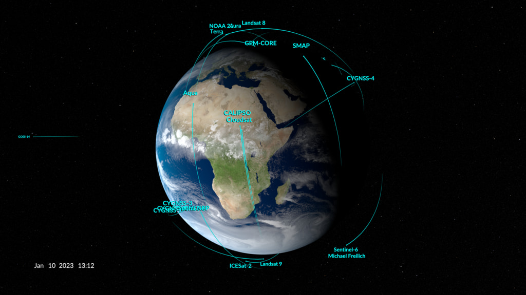
This animation shows the orbits of NASA's fleet of Earth-observing missions as of January 2024. For more than fifty years, NASA missions have studied the Earth. The current fleet of satellites and sensors provide up-to-date information about Earth’s oceans, freshwater, land, and air on a global scale. The publicly available data collected from Earth-observing missions allows us to understand how Earth’s dynamic systems interact.
Earth Observing Fleet Science On a Sphere Content
This animation shows the orbits of NASA's fleet of Earth-observing missions as of January 2024. For more than 60 years, NASA missions have studied the Earth. The current fleet of satellites and sensors provide daily information about Earth’s oceans, freshwater, land, and air around the world. The data collected by these Earth-observing missions allows us to understand how Earth’s dynamic systems interact.

A still image of NASA's Earth observing fleet (flat SOS version), on a globe

A still image of NASA's Earth observing fleet (flat SOS version), on a globe
These visualizations show the current orbits of NASA's fleet of Earth observing spacecraft. Satellite orbits are generated using today's two-line element sets (TLEs).
Spacecraft included:
• Aqua
• Aura
• CYGNSS-1: Cyclone Global Navigation Satellite System 1
• CYGNSS-2: Cyclone Global Navigation Satellite System 2
• CYGNSS-3: Cyclone Global Navigation Satellite System 3
• CYGNSS-4: Cyclone Global Navigation Satellite System 4
• CYNGSS-5: Cyclone Global Navigation Satellite System 5
• CYGNSS-7: Cyclone Global Navigation Satellite System 7
• CYGNSS-8: Cyclone Global Navigation Satellite System 8
• GPM: Global Precipitation Measurement
• GRACE-FO-1: Gravity Recovery and Climate Experiment Follow On-1
• GRACE-FO-2: Gravity Recovery and Climate Experiment Follow On-2
• ICESat-2
• ISS: International Space Station
• Landsat 8
• Landsat 9
• OCO-2: Orbiting Carbon Observatory-2
• PACE: Plankton, Aerosol, Cloud, ocean Ecosystem
• SMAP: Soil Moisture Passive Active
• Suomi NPP: Suomi National Polar-orbiting Partnership
• Sentinel-6 Michael Freilich
• SWOT
• Terra
• TROPICS-01 (Pathfinder)
• TROPICS-03
• TROPICS-05
• TROPICS-06
• TROPICS-07
The clouds used in this version are from a high resolution GEOS model run at 10 minute time steps interpolated down to the per-frame level. The timeframe for this model does not match the date in this fleet visualization, so the clouds shown do not represent actual conditions for today.
Credits
Please give credit for this item to:
NASA's Scientific Visualization Studio
-
Visualizers
-
Kel Elkins
(USRA)

-
Greg Shirah
(NASA/GSFC)
-
Kel Elkins
(USRA)
Datasets used
-
CelesTrak Spacecraft Orbit Ephemeris
ID: 454This dataset can be found at: http://celestrak.com
See all pages that use this dataset
Note: While we identify the data sets used on this page, we do not store any further details, nor the data sets themselves on our site.
Related
- ID: 14508
- ID: 5061
 Visualization
Release date
This page was originally published on Friday, May 16, 2025.
This page was last updated on Thursday, May 15, 2025 at 6:05 PM EDT.