Lunar Transit from Solar Dynamics Observatory (2010)
Just as we do on Earth, the Solar Dynamics Observatory satellite periodically crosses the Moon's shadow and experiences a solar eclipse. During the eclipse witnessed by SDO on October 7, 2010, the southern hemisphere of the Moon was silhouetted against the solar disk, revealing some especially prominent mountain peaks near the Moon's south pole. By using elevation data from Lunar Reconnaissance Orbiter to visualize the Moon from SDO's point of view, it's possible to identify these peaks. Although all of these are well-known features, all but one of them have no official names. The following list corresponds to the labels in the animation, from left to right.
- In his 1954 sketch of the lunar south pole, astronomer Ewen Whitaker labeled this feature "M3." It's a mountain about halfway between the craters Cabeus and Drygalski, at 83.2°S 68°W.
- Whitaker's "M1," a mountain on the northern rim of Cabeus, 83.4°S 33°W.
- A mountain on the southern rim of Malapert crater, about halfway between the centers of Malapert and Haworth. Whitaker labels this Malapert Alpha. It's also known as Mons Malapert or Malapert Peak. 85.8°S 0°E.
- Labeled Leibnitz Beta by Whitaker and now officially named Mons Mouton, this is part of the highlands adjacent to the northern rim of Nobile crater. 84°S 37°E. Part of the Leibnitz mountain range first identified by Johann Schröter in the late 1700s, unrelated to Leibnitz Crater on the lunar far side.
- A mountain near Amundsen crater, on the western (Earthward) rim of Hédervári crater, 82.2°S 75°E. Whitaker tentatively labels this Leibnitz Epsilon in his sketch.
The Moon visualization uses the latest albedo and elevation maps from Lunar Reconnaissance Orbiter (LRO).
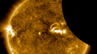
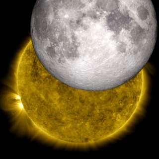
The southern limb of the Moon transits across the Sun in this sequence of images from Solar Dynamics Observatory on October 7, 2010. Five peaks near the lunar south pole, visible in silhouette, are identified. A visualization of the Moon using Lunar Reconnaissance Orbiter data is precisely aligned with the SDO image, then rotated to show these five peaks on a false-color global elevation map.
This video is also available on our YouTube channel.
The complete solar eclipse as photographed by SDO over a span of two hours on October 7. The sequence runs from 10:40 to 12:39 Universal Time (6:40 to 8:39 Eastern Daylight Time). The 3840 x 2160 frame set in this group is at the original SDO image resolution but has been cropped to a 16:9 frame aspect.
The complete sequence of full-frame, full-resolution SDO images. The "Time" directory names the files with a time stamp, while the "Frames" directory numbers the image files sequentially. Some images in "Frames" are repeated in order to maintain a constant time step.

A close-up of the Moon's south pole with several features labeled. These features are identified in the text.
A composite of the SDO image and the Moon visualization showing the excellent correspondence between the two along the Moon's silhouette edge.
The Moon by itself, with an alpha channel, at the same scale as the SDO image.
For More Information
Credits
Please give credit for this item to:
NASA's Goddard Space Flight Center Scientific Visualization Studio
-
Animators
-
Ernie Wright
(USRA)

- Tom Bridgman (Global Science and Technology, Inc.)
-
Ernie Wright
(USRA)
-
Producer
- Scott Wiessinger (USRA)
Missions
This page is related to the following missions:Datasets used
-
[LRO: LROC]
ID: 212 -
DEM (Digital Elevation Map) [LRO: LOLA]
ID: 653 -
AIA 171 (171 Filter) [SDO: AIA]
ID: 680This dataset can be found at: http://jsoc.stanford.edu/
See all pages that use this dataset -
DE421 (JPL DE421)
ID: 752Planetary ephemerides
This dataset can be found at: http://ssd.jpl.nasa.gov/?ephemerides#planets
See all pages that use this dataset
Note: While we identify the data sets used on this page, we do not store any further details, nor the data sets themselves on our site.
Related
- ID: 12688
 Produced Video
 - ID: 11291
 Produced Video
Release date
This page was originally published on Wednesday, June 12, 2013.
This page was last updated on Sunday, February 2, 2025 at 10:11 PM EST.