Extreme Russian Fires and Pakistan Floods Linked Meteorologically
In the summer of 2010, months of record-breaking drought and temperatures culminated with a rash of fires that ravaged western Russia for weeks. Temperatures in Moscow soared to an average of 104 °F (40 °C) during late July and early August — more than 18 °F (10 °C) above normal. Hundreds of fires broke out producing some $15 million in damages. The heat and smoke killed about 56,000 people, making the Russian wildfires fires one of the most lethal natural disasters of the year.
Meanwhile, some 930 kilometers (1,500 miles) away, relentless rainfall was simultaneously pounding Pakistan and generating intense flooding. The Pakistan Meteorological Department reported nationwide rain totals 70 percent above normal in July and 102 percent above normal in August.
New research conducted by William Lau, an atmospheric scientist at NASA's Goddard Space Flight Center in Greenbelt, Md., suggests the two seemingly disconnected events were actually closely linked.
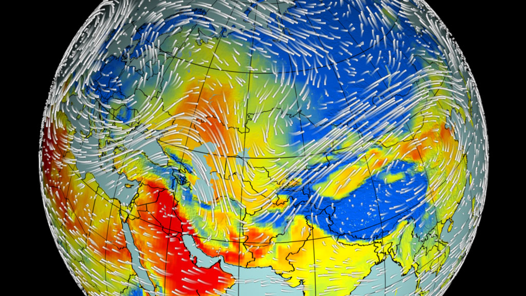
Under normal circumstances, the jet stream pushes weather fronts through Eurasia in four or five days, but something unusual happened in July of 2010. A large-scale, stagnant weather pattern — known as an Omega blocking event — slowed the Rossby wave over Russia and prevented the normal progression of weather systems from west to east.
As a result, a large region of high-pressure formed over Russia trapping a hot, dry air mass over the area. As the high lingered, the land surface dried and the normal transfer of moisture from the soil to the atmosphere slowed. Precipitation ceased, vegetation dried out, and the region became a taiga tinderbox.
Meanwhile, the blocking pattern created unusual downstream wind patterns over Pakistan. Areas of low pressure on the leading edge of the Rossby wave formed in response to the high, pulling cold, dry Siberian air into lower latitudes.
This cold air from Siberia clashed with warm, moist air arriving over Pakistan from the Bay of Bengal as part of the monsoon. There's nothing unusual about moisture moving north over India toward the Himalayas. It's a normal part of the monsoon. However, in this case, the unusual wind patterns associated with the blocking high brought upper level air disturbances farther south than typical, which in effect helped shifted the entire monsoon system north and west.
This brought heavy monsoon rains — centered over parts of India — squarely over the northern part of Pakistan, a region ill-prepared to handle large amounts of rain.
Animation of Teleconnection Between Russia and Pakistan
This video is also available on our YouTube channel.
Credits
Please give credit for this item to:
NASA/Goddard Space Flight Center Scientific Visualization Studio
-
Animator
- Trent L. Schindler (USRA)
-
Producer
- Adam P Voiland (Wyle Information Systems)
-
Scientists
- William K. Lau (NASA/GSFC)
- Kyu-Myong Kim (Morgan State University)
-
Writer
- Adam P Voiland (Wyle Information Systems)
Missions
This page is related to the following missions:Datasets used
-
[Aqua: AIRS]
ID: 3For more information on the Atmospheric Infrared Sounder, click http://www-airs.jpl.nasa.gov/
See all pages that use this dataset -
[Aqua: MODIS]
ID: 5 -
[Terra: MODIS]
ID: 116 -
3-hour Rainmap (3B4XRT) [TRMM and DMSP: SSM/I and TMI]
ID: 526This dataset can be found at: http://cics.umd.edu/~msapiano/PEHRPP/3b42rt.html
See all pages that use this dataset -
MERRA
ID: 684
Note: While we identify the data sets used on this page, we do not store any further details, nor the data sets themselves on our site.
Related
- ID: 10820
 Produced Video
Release date
This page was originally published on Tuesday, August 30, 2011.
This page was last updated on Sunday, January 5, 2025 at 10:04 PM EST.