Magnetospheric Multiscale Mission (MMS) Dayside Orbit Animation for the Preliminary Design Review (PDR)
This visualization uses simulated ephemerides to show the proposed orbits of the Magnetospheric Multiscale Mission (MMS) during the "dayside magnetosheath/magnetopause" orbit phase. The movie initially shows the general orientation of the orbit with respect to the Earth, Moon, and Sun. It then zooms in to "ride" along with the spacecraft. We then zoom in even closer to show that there are actually four spacecraft flying in a tetrahedral formation. Finally, we see how the 4 spacecraft skim the magnetosheath such that, occasionally, some of the spacecraft are inside (e.g., MMS #1) and some are outside (e.g., MMS #2, #3, and #4) of the magnetosheath boundary.
This visualization was created in support of the MMS Preliminary Design Review (PDR) which was held May 4 - 7, 2009.
MMS dayside magnetosheath/magnetopuase orbit configuration

Earth, magnetoshealth, Moon's orbit, and the Sun
View from Earth's north (i.e., top down) showing the Moon's orbit, the magnetosheath, and the MMS dayside magnetosheath/magnetopause orbit
Another top down view showing how the MMS dayside magnetosheath/magnetopause orbit takes the spacecraft to the magnetosheath boundary (available with and without labels)
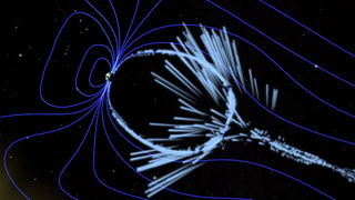
MMS orbit with Earth's magnetic field lines (available with and without labels)
The tetrahedral flying configuration of the 4 MMS spacrcraft (available with and without labels)
Another view of the tetrahedral MMS formation (available with and without labels)
Close up of MMS tetrahedron skimming the magnetosheath - some of the spacecraft (e.g., MMS #1) are inside the boundary while others (e.g., MMS #2, #3, and #4) are outside
Credits
Please give credit for this item to:
NASA/Goddard Space Flight Center Scientific Visualization Studio
The Blue Marble Next Generation data is courtesy of Reto Stockli (NASA/GSFC) and NASA's Earth Observatory.
-
Animators
-
Greg Shirah
(NASA/GSFC)

- Tom Bridgman (Global Science and Technology, Inc.)
- Ernie Wright (UMBC)
-
Greg Shirah
(NASA/GSFC)
-
Producer
- Chris Smith (HTSI)
-
Scientist
- Mark L. Adrian (NASA/GSFC)
Missions
This page is related to the following missions:Datasets used
-
BMNG (Blue Marble: Next Generation) [Terra and Aqua: MODIS]
ID: 508Credit: The Blue Marble data is courtesy of Reto Stockli (NASA/GSFC).
This dataset can be found at: http://earthobservatory.nasa.gov/Newsroom/BlueMarble/
See all pages that use this dataset -
Tycho Catalogue (Tycho 2 Catalogue) [Hipparcos: Telescope]
ID: 550This dataset can be found at: http://archive.eso.org/ASTROM/
See all pages that use this dataset -
CPC (Climate Prediction Center) Cloud Composite
ID: 600Global cloud cover from multiple satellites
See all pages that use this dataset -
Simulated MMS Ephemeris
ID: 613 -
Magnetic Field Lines (Luhmann-Friesen) [Luhmann-Friesen Magnetosphere Model (1979)]
ID: 615Journal of Geophysical Research, vol. 84, Aug. 1, 1979, p. 4405-4408
This dataset can be found at: http://adsabs.harvard.edu/abs/1979JGR....84.4405L
See all pages that use this dataset
Note: While we identify the data sets used on this page, we do not store any further details, nor the data sets themselves on our site.
Related
- ID: 11485
 Produced Video
Release date
This page was originally published on Monday, July 6, 2009.
This page was last updated on Wednesday, May 3, 2023 at 1:54 PM EDT.