A newer version of this visualization is available.
Ozonewatch 2015

Ozone hole size plots and October 1st images from 1979-2015
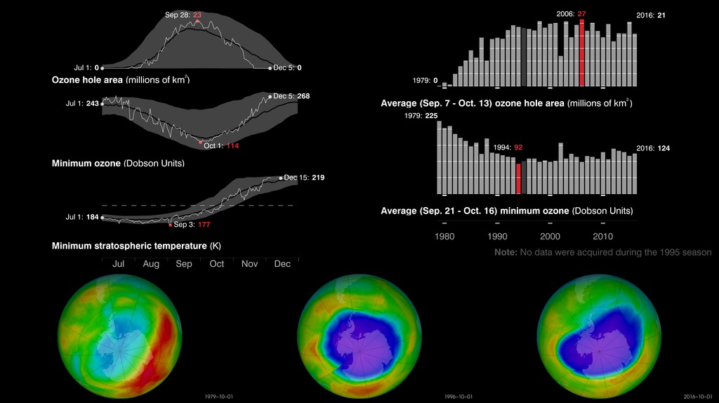
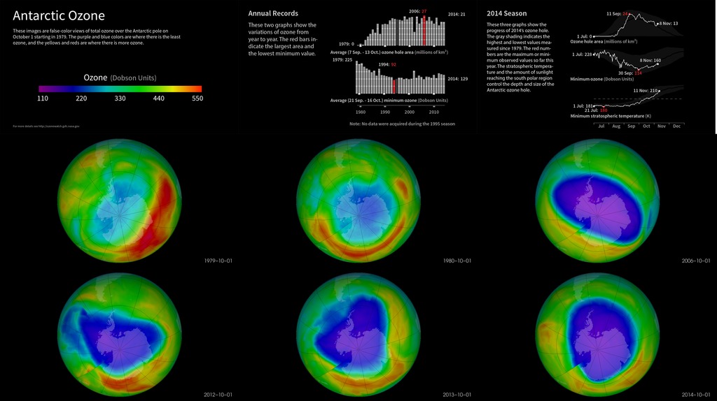
Each year for the past few decades during the Southern Hemisphere spring, chemical reactions involving chlorine and bromine cause ozone in the southern polar region to be destroyed rapidly and severely. This depleted region is known as the “ozone hole.”
The area of the ozone hole is determined from a map of total column ozone. It is calculated from the area on the Earth that is enclosed by a line with a constant value of 220 Dobson Units (a unit of measure for total ozone.) The value of 220 Dobson Units is chosen since total ozone values of less than 220 Dobson Units were not found in the historic observations over Antarctica prior to 1979. Also, from direct measurements over Antarctica, a column ozone level of less than 220 Dobson Units is a result of the ozone loss from chlorine and bromine compounds.
This Hyperwall series shows the recent status of the ozone layer over the Antarctic, with a focus on the ozone hole. Satellite instruments monitor the ozone layer, and OzoneWatch uses their data to create the images that depict the amount of ozone.
July-December animations of ozone for selected years from 1979 to 2015
Ozone hole on October 1 for selected years between 1979-2015
Ozone hole on December 1 for selected years between 1979-2015.
For More Information
Credits
Please give credit for this item to:
NASA's Goddard Space Flight Center
-
Scientist
- Paul Newman (NASA/GSFC)
-
Technical support
- Marit Jentoft-Nilsen (Global Science and Technology, Inc.)
Related
- ID: 30602
 Hyperwall Visual
Newer Versions
- ID: 30844
 Hyperwall Visual
Older Versions
- ID: 30078
 Hyperwall Visual
Release date
This page was originally published on Thursday, December 10, 2015.
This page was last updated on Sunday, February 2, 2025 at 12:34 AM EST.