The Birth of a New Island: Press Materials
Music: Fountain by Mailcoat Sheppard; Data Visions by Pike; Guilty Curiosity by Brice Davoli; Concerning Nymphs by Hammond Roberts.
Complete transcript available.
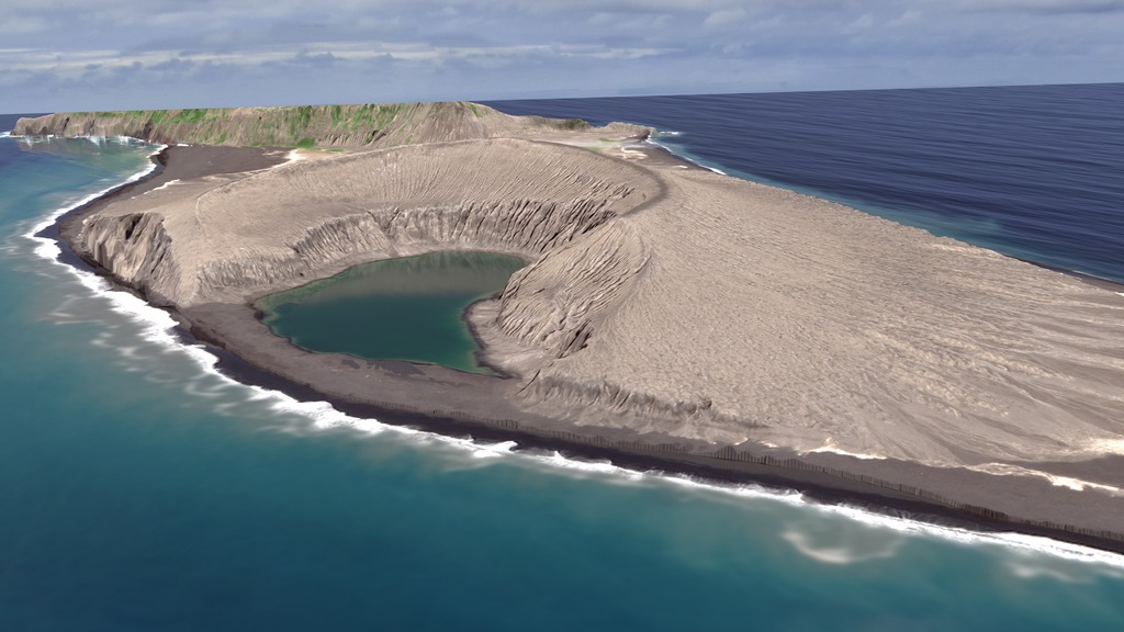
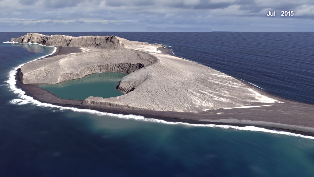
In late December 2014, a submarine volcano in the South Pacific Kingdom of Tonga erupted, sending a violent stream of steam, ash and rock into the air. The ash plumes rose as high as 30,000 feet (9 kilometers) into the sky, diverting flights. When the ash finally settled in January 2015, a newborn island with a 400-foot (120-meter) summit nestled between two older islands – visible to satellites in space.
The newly formed Tongan island, unofficially known as Hunga Tonga-Hunga Ha'apai after its neighbors, was initially projected to last a few months. Now it has a 6- to 30-year lease on life, according to a new NASA study.
Hunga Tonga-Hunga Ha'apai is the first island of this type to erupt and persist in the modern satellite era, it gives scientists an unprecedented view from space of its early life and evolution. The new study offers insight into its longevity and the erosion that shapes new islands. Understanding these processes could also provide insights into similar features in other parts of the solar system, including Mars.
"Volcanic islands are some of the simplest landforms to make," said first author Jim Garvin, chief scientist of NASA's Goddard Space Flight Center in Greenbelt, Maryland. "Our interest is to calculate how much the 3D landscape changes over time, particularly its volume, which has only been measured a few times at other such islands. It's the first step to understand erosion rates and processes and to decipher why it has persisted longer than most people expected."
The Tongan island is the third “surtseyan” volcanic island in the last 150 years to emerge and persist for more than a few months. Surtsey is an island that began forming during a similar kind of explosive, marine eruption off the coast of Iceland in 1963.
From the Tongan island’s beginning, it was tracked by monthly, high-resolution satellite observations, both with optical sensors and radar, which sees through clouds. Alerted to the volcanic eruption by NASA's Rapid Response program for the Moderate Resolution Imaging Spectroradiometer (MODIS) instruments, Garvin and his colleagues directed satellites to observe the island as soon as the eruption ended. Using this imagery, the research team made three-dimensional maps of the island’s topography and studied its changing coastlines and volume above sea level.
The team has calculated two potential scenarios affecting its lifetime. The first is a case of accelerated erosion by wave abrasion, which would destabilize the tuff cone in six to seven years, leaving only a land-bridge between the two adjacent older islands. The second scenario presumes a slower erosion rate, which leaves the tuff cone intact for about 25-30 years.
This visualization shows the change in the island of Hunga Tonga Hunga Ha'apa between January 2015 and September 2017. This visualization depicts the eruption that preceded the island formation.
This visualization shows the change in the island of Hunga Tonga Hunga Ha'apa between January 2015 and September 2017.
View of crater lake from the summit rim, June 4-5, 2017.
Credit: NASA/Damien Grouille/Cecile Sabau
View of crater lake from the summit rim, June 4-5, 2017.
Credit: NASA/Damien Grouille/Cecile Sabau
View of crater lake from the summit rim, June 4-5, 2017.
Credit: NASA/Damien Grouille/Cecile Sabau
In April 2015, we watched an isthmus bridge begin forming from the new island to the older island neighboring it to the east. Soft volcanic material, especially on the island’s southern side, was eroded by the ocean and deposited on the tail end, which grew and grew till it reached the other island. It’s about 1600 feet (500 meters) across, or the length of 5 football fields.
The erosive forces of the ocean broke down the southern wall of the crater lake in May 2015. We thought this might mean that the island wouldn’t last much longer because the ocean could now attack the interior of the island’s tuff cone. But in June, a sandbar formed, closing off the lake again and protecting the interior. The sandbar has been in place ever since.
 through the present (blues). Credit: NASA")
The Sept. 19th satellite image of the Tongan island is overlain with lines that show its previous coastlines from Jan. 2015 (red) through the present (blues). Credit: NASA
")
This synthetic aperture radar image from the Canadian Space Agency's RadarSat-2 shows the Tongan island's topography in detail that complements the optical sensors, Nov. 24, 2017.
Credit: ©MacDonald, Dettwiler and Associates LTD. (2017)

Digital elevation model derived from stereo views of a Martian volcano from the HiRISE instrument aboard Mars Reconnaissance Orbiter.
Credit: NASA/JPL/U. Arizona

High-resolution satellite image of the Tongan island right after it formed, Jan. 19, 2015.
Credit: Pleiades-1A ©2015 CNES Distribution Airbus DS
 and the new Tongan island (right).
Credit: NASA")
Digital elevation model derived from stereo satellite images shows the topography of Surtsey, Iceland, formed in 1963 (left) and the new Tongan island (right).
Credit: NASA

Tephra surface of the Tongan island, June 4-5, 2017.
Credit: NASA/Damien Grouille/Cecile Sabau

View of crater lake from the summit rim, June 4-5, 2017.
Credit: NASA/Damien Grouille/Cecile Sabau

Tephra cliffs compose the interior crater wall, June 4-5, 2017.
Credit: NASA/Damien Grouille/Cecile Sabau

Tephra cliffs compose the interior crater wall, June 4-5, 2017.
Credit: NASA/Damien Grouille/Cecile Sabau

Tephra surface of the Tongan island, June 4-5, 2017.
Credit: NASA/Damien Grouille/Cecile Sabau

View of crater lake from the summit rim, June 4-5, 2017.
Credit: NASA/Damien Grouille/Cecile Sabau

View of crater lake from the summit rim, June 4-5, 2017.
Credit: NASA/Damien Grouille/Cecile Sabau

Sediment from the eroded cliffs form a beach around the crater lake, June 4-5, 2017.
Credit: NASA/Damien Grouille/Cecile Sabau

Tephra cliffs compose the interior crater wall. A sandbar on the southern side of the island walls off the crater lake from the ocean, June 4-5, 2017.
Credit: NASA/Damien Grouille/Cecile Sabau

Digital elevation model derived from stereo satellite images shows the topography of the new island. Left: Apr. 21, 2015. Right: Sept. 19, 2017.
Credit: NASA

High-resolution satellite image of the Tongan island at 31 months Sept. 19, 2017.
Credit: ©2017 DigitalGlobe
For More Information
Credits
Please give credit for this item to:
NASA's Goddard Space Flight Center
-
Producer
- LK Ward (USRA)
-
Scientists
- James Garvin (NASA, Chief Scientist Goddard)
- Daniel A. Slayback (SSAI)
- Vicki Ferrini (Lamont-Doherty Earth Observatory, Columbia University)
-
Visualizer
-
Cindy Starr
(Global Science and Technology, Inc.)

-
Cindy Starr
(Global Science and Technology, Inc.)
-
Writer
- Ellen T. Gray (ADNET Systems, Inc.)
-
Associate producer
- Kathryn Mersmann (USRA)
Series
This page can be found in the following series:Related
- ID: 4726
 Visualization
 - ID: 4635
Alternate Versions
- ID: 12784
 Produced Video
Sources
- ID: 4602
 Visualization
Release date
This page was originally published on Monday, December 11, 2017.
This page was last updated on Tuesday, September 3, 2024 at 1:54 PM EDT.