Cool Craters

On dwarf planet Ceres, scientists map craters where ice can accumulate.
Since NASA’s Dawn spacecraft arrived at Ceres in March 2015, scientists have learned a lot about the dwarf planet. Now, by combining images taken by the spacecraft with a computer model, researchers mapped locations in Ceres’ northern hemisphere that are in constant darkness. These dark areas, called permanently shadowed regions, only receive indirect light from the sun. This keeps their surface temperature extremely low, allowing ice to collect over time. The areas are typically located on a crater floor or along a section of a crater wall facing toward the pole. Scientists think most have been cold enough to accumulate water ice for a billion years, suggesting that ice deposits could exist there now. Future studies of these regions could help explain the origin of ice seen in shadowed craters on other worlds in our solar system. Watch the video for a close look at Ceres' permanently shadowed regions.
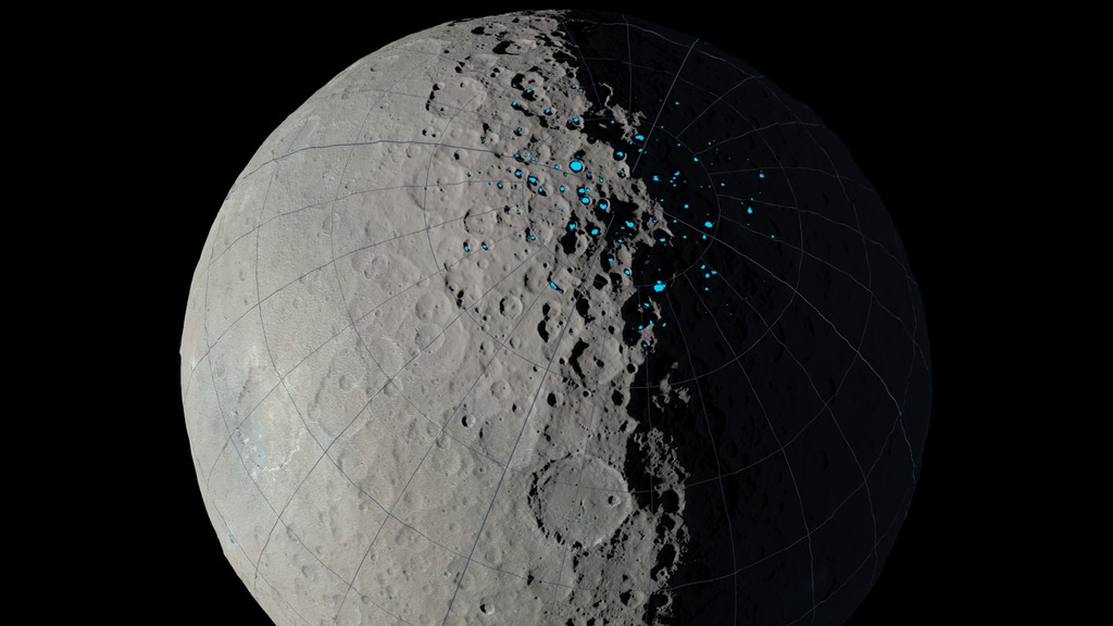
This visualization shows the location of permanently shadowed regions in Ceres' northern hemisphere.
Images of Ceres taken from orbit helped researchers identify dozens of permanently shadowed regions on the dwarf planet.
Areas colored blue above highlight the nearly 700 square miles of terrain in Ceres' north polar region that is in constant darkness.
NASA's Dawn spacecraft has collected thousands of images of Ceres, providing scientists with the first detailed views of its surface.
For More Information
See NASA.gov
Credits
Please give credit for this item to:
NASA's Scientific Visualization Studio
Ceres surface close-up image courtesy of NASA/JPL-Caltech/UCLA/MPS/DLR/IDA
Dawn spacecraft image courtesy of NASA/JPL-Caltech
-
Writer
- Elizabeth Zubritsky (ADNET Systems, Inc.)
-
Producer
- Dan Gallagher (USRA)
-
Scientist
- Erwan M. Mazarico (NASA/GSFC)
-
Animator
-
Ernie Wright
(USRA)

-
Ernie Wright
(USRA)
-
Video editor
- Sophia Roberts (USRA)
Sources
- ID: 4475
 Visualization
Release date
This page was originally published on Thursday, July 14, 2016.
This page was last updated on Wednesday, May 3, 2023 at 1:48 PM EDT.