Tracking Volcanic Ash

NASA satellite data could help reduce flights sidelined by volcanic eruptions.
When a volcano erupts, it can wreak just as much havoc in the air than on land. The expanding plume of ash that rises into the atmosphere is a danger to aircraft and can damage engines, causing them to fail midflight. Because the plumes often look like ordinary rain clouds on radar and to a pilot's eye, they can be difficult to detect. Out of caution, smoke-spewing volcanoes are given a wide berth, leading to costly flight delays and cancellations. To help improve the flow of air traffic, NASA scientists are using data collected by the Earth-observing Suomi NPP satellite to map the full three-dimensional structure of volcanic clouds. By measuring the location and height of particles within the cloud, as well as the amount of sulfur dioxide gas in the air, scientists can create improved models of weather patterns, allowing a more accurate forecast of where the hazardous ash is spreading—information air traffic managers can use to reroute flights and keep passengers out of harm’s way. Watch the video to learn more.
Explore how scientists are using satellite data to model the flow of gases and particles released from a volcanic eruption in this video.
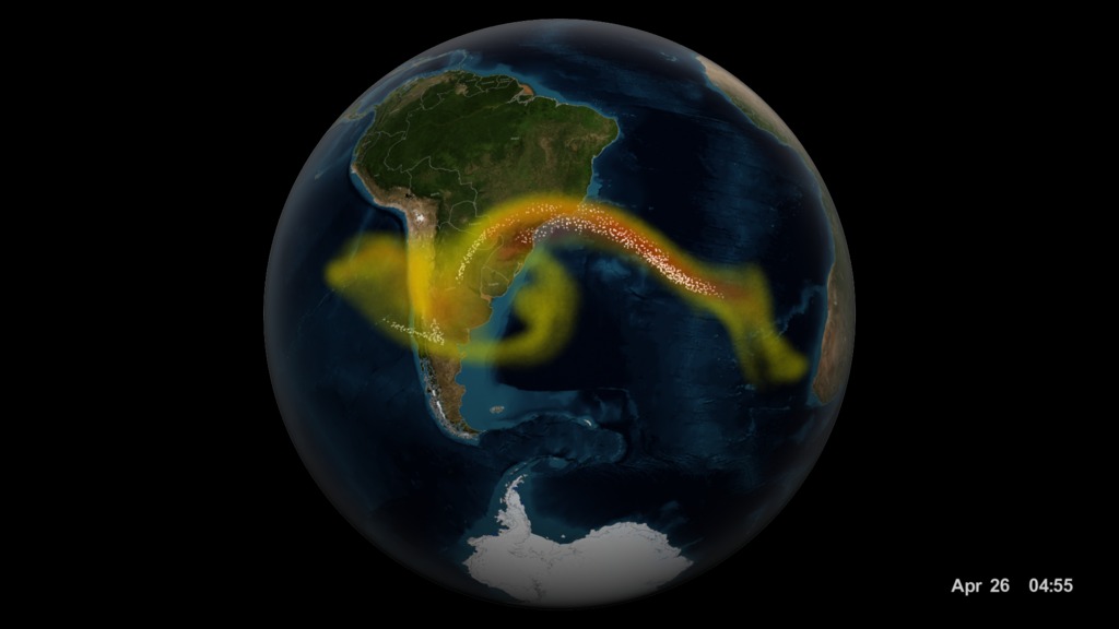
This image shows a plume of ash (white dots) and sulfur dioxide gas (yellow, red) rising from Chile's Calbuco volcano during an eruption in 2015.
The ash and gas are transported by winds high into the atmosphere where they can persist for days, weeks or longer.
The Suomi NPP satellite measures levels of sulfur dioxide, and maps the vertical profile of ash within the plume, shown as cross sections above.
The information collected by the satellite helps scientists to create improved forecasts of where the volcanic cloud is spreading.
This photo taken from the International Space Station days after the 2015 Calbuco eruption shows a volcanic cloud drifting in Earth's atmosphere.
For More Information
See NASA.gov
Credits
Please give credit for this item to:
NASA's Scientific Visualization Studio
ISS photo courtesy of NASA/ESA/S. Cristoforetti
-
Writers
- Audrey Haar (Telophase)
- Matthew R. Radcliff (USRA)
-
Producer
- Matthew R. Radcliff (USRA)
-
Animator
-
Kel Elkins
(USRA)

-
Kel Elkins
(USRA)
-
Scientists
- Nickolay Krotkov (NASA/GSFC)
- Eric J. Hughes (UMD)
-
Narrator
- Jefferson Beck (USRA)
Sources
- ID: 12221
 Produced Video
Release date
This page was originally published on Thursday, May 19, 2016.
This page was last updated on Wednesday, May 3, 2023 at 1:48 PM EDT.