Coastal Fly Down from Santa Barbara to Los Angeles
Coastal fly down from Santa Barbara to LA (N to S).
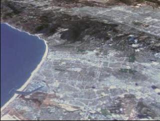
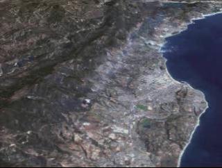
Flying down the coast of California from Santa Barbara to
Los Angeles. Using Landsat 7 dataset of California and USGS elevation data, we
are albe to fly in 3D space and view this beautiful area.

Video slate image reads, "Coastal Fly Down from Santa Barbara, Ca. to Los Angeles, Ca."
Credits
Please give credit for this item to:
NASA/Goddard Space Flight Center
Scientific Visualization Studio
-
Animator
- Stuart A. Snodgrass (Global Science and Technology, Inc.)
-
Scientist
- Darrel Williams (NASA/GSFC)
Missions
This page is related to the following missions:Series
This page can be found in the following series:Datasets used
-
[Landsat-7: ETM+]
ID: 55This dataset can be found at: http://landsat.gsfc.nasa.gov/about/wrs.html
See all pages that use this dataset
Note: While we identify the data sets used on this page, we do not store any further details, nor the data sets themselves on our site.
Related
- ID: 1230
 Visualization
Alternate Versions
- ID: 1225
 Visualization
 - ID: 1229
 Visualization
Release date
This page was originally published on Monday, November 1, 1999.
This page was last updated on Wednesday, May 3, 2023 at 1:58 PM EDT.