Invisible Earth
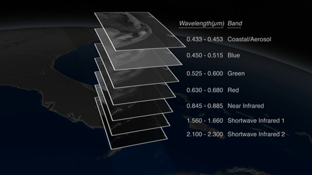
In our photo-saturated world, it’s natural to think of satellite images as snapshots from space. But most aren’t. A satellite image is created by combining measurements of the intensity of certain wavelengths of light, both visible and invisible to humans. When we combine measurements of visible light, the resulting image is true color, or similar to what our eyes would see. When we use non-visible light (usually infrared measurements), the resulting image is false color, and things might look different than we’d expect. Watch the video to see how distinct combinations of light are combined to create powerful and informing satellite views of our planet.

Learn about how satellites reveal features of our planet that aren't visible to human eyes.
Explore how the NASA-USGS Landsat 8 satellite uses different combinations of light to provide information about Florida's land in this video.
Infrared light reveals details of the evolving lava flows on Russia’s Tolbachik Volcano.
Comparing the differences between three infrared wavelengths highlights the mineral geology surrounding China’s Piqiang Fault.
Near infrared, red, and green light were used to create this false-color image of Algeria. Plant-covered land (red) dominates the scene.
For More Information
Credits
Please give credit for this item to:
NASA's Earth Observatory
Cover image courtesy of NASA/Johns Hopkins University Applied Physics Laboratory/Carnegie Institution of Washington
Volcano image courtesy of NASA Earth Observatory/Jesse Allen and Robert Simmon
China image courtesy of NASA Earth Observatory/Robert Simmon
Algeria image courtesy of NASA Earth Observatory/Robert Simmon
-
Animator
-
Alex Kekesi
(Global Science and Technology, Inc.)

-
Alex Kekesi
(Global Science and Technology, Inc.)
-
Video editor
- Matthew R. Radcliff (USRA)
-
Narration
- Kate Ramsayer (Telophase)
- Matthew R. Radcliff (USRA)
- James R. Irons (NASA/GSFC)
-
Producer
- Matthew R. Radcliff (USRA)
-
Scientist
- James R. Irons (NASA/GSFC)
-
Videographers
- Matthew R. Radcliff (USRA)
- Rob Andreoli (Advocates in Manpower Management, Inc.)
-
Writer
- Holli Riebeek (Sigma Space Corporation)
Related
- ID: 11491
 Produced Video
Release date
This page was originally published on Thursday, March 27, 2014.
This page was last updated on Wednesday, May 3, 2023 at 1:51 PM EDT.