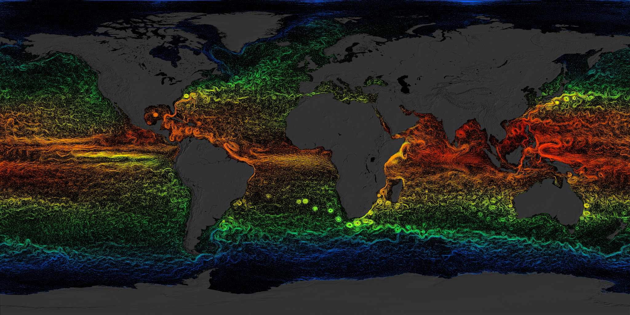
Swirling Seas
As Earth hurtles around its axis at 1,000 miles per hour, its rotation sets the seas in motion and generates winds that bear down on the ocean surface. The fast-moving currents, swirling eddies and powerful drifts that result appear at first glance as a disorderly jumble of flows. Yet their movements are directed by enormous, rotating currents, called gyres, which slowly circulate water around the planet's major ocean basins. The visualizations below combine NASA satellite data with field measurements to present a modeled view of surface flows and gyres in the Northern Hemisphere from March 2007 to March 2008. Observe the dramatic difference in strength between westward and eastward currents as they hook clockwise in the Atlantic and Pacific oceans. And notice how westward currents explode into spiraling, turbulent flows off the eastern coasts of Asia and North America.

Earth, wind and water combine to create the world's endless ocean currents.
Longer streams represent faster currents. Here, fast Pacific flows rush toward Asia before turning to the northeast.
The slow-moving California Current flows south along the U.S. before picking up pace near the equator.
Strong westward flows in the Atlantic help create the Gulf Stream. Watch for a slow-forming loop current off the western tip of Cuba.
The clockwise movement of the Atlantic gyre is nearly imperceptible along the coastline of northern Africa.
This depiction of the Atlantic gyre comes from a 1943 U.S. Army atlas.
Earlier maps captured the movement of dominant currents such as the Pacific gyre, shown above, but lack the minute detail seen in the NASA model.
Credits
Please give credit for this item to:
NASA's Goddard Space Flight Center
-
Animators
-
Greg Shirah
(NASA/GSFC)

- Horace Mitchell (NASA/GSFC)
- Eric Sokolowsky (Global Science and Technology, Inc.)
-
Greg Shirah
(NASA/GSFC)
-
Producer
- Michael Starobin (HTSI)
-
Scientists
- Hong Zhang (UCLA)
- Dimitris Menemenlis (NASA/JPL CalTech)
-
Writer
- Patrick Lynch (Wyle Information Systems)
Related
- ID: 3912
 Visualization
Release date
This page was originally published on Thursday, April 26, 2012.
This page was last updated on Wednesday, May 3, 2023 at 1:53 PM EDT.