Tapped Dry In Vegas
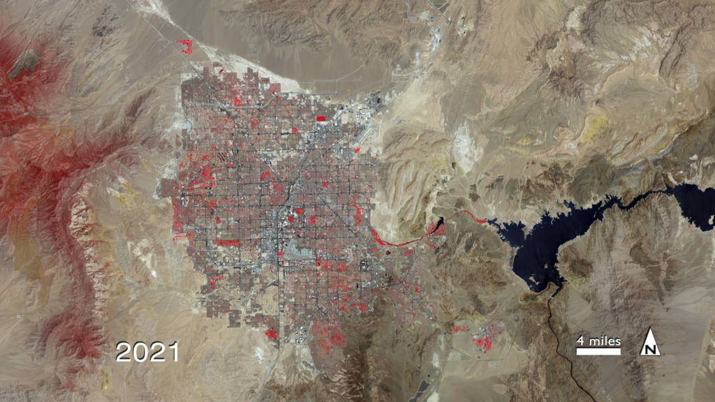
The constant influx of residents to Las Vegas since the 1970s has made it one of the fastest-growing metropolitan areas in the world. Currently more than 2 million people live in the 600-square-mile desert region, centered around the world-famous Las Vegas Strip and its luxury resorts and casinos. No doubt, the steady commercial and residential development over the last 40 years has been a boon to the valley's economy, but dense urbanization has exacted a high price on its most vital natural resource: water. Abundant parks, golf courses and manicured landscapes in Las Vegas' arid climate require more water to maintain than they naturally receive. This has placed an unsustainable demand on the region's primary water supply—Lake Mead—where water levels have fallen in the past decade due to persistent drought experienced across the Southwest. Scientists predict drought frequency and intensity for the region will only increase as global temperatures rise. In the collection of false-color, time-lapse images below captured by USGS-NASA Landsat satellites, witness Las Vegas' explosive growth from 1972 to 2010.

Las Vegas is all in, but how long until its water runs out?
Watch as irrigated vegetation (red) and impervious surfaces (gray) expand outwards from the valley.
A majority of its population, more than 1,500,000 people, moved to Las Vegas since 1972.
Lake Mead's water (black) is seen in decline in the past decade.
Parks and golf courses (red) comprise the majority of irrigated vegetation seen surrounding the Las Vegas Strip (center).
Bright light city: The desert's edge cuts a clean line in this astronaut photo taken aboard the International Space Station on Nov. 30, 2010.
Landsat 7, launched April 15, 1999, is the most recent Landsat satellite in NASA's Earth Observing fleet.
For More Information
See NASA.gov
Credits
Please give credit for this item to:
NASA's Goddard Space Flight Center
Landsat images obtained from USGS Earth Explorer
Night photograph of Las Vegas obtained from The Gateway to Astronaut Photography of Earth, Image Science and Analysis Laboratory, NASA-Johnson Space Center
The Landsat Program is a series of Earth-observing satellite missions jointly managed by NASA and the U.S. Geological Survey.
-
Animator
- Marit Jentoft-Nilsen (RSIS)
-
Video editor
- Matthew R. Radcliff (USRA)
-
Producer
- Matthew R. Radcliff (USRA)
-
Scientist
- James R. Irons (NASA/GSFC)
-
Writer
- Kayvon Sharghi (USRA)
Related
- ID: 10721
 Produced Video
Release date
This page was originally published on Thursday, August 18, 2011.
This page was last updated on Thursday, October 10, 2024 at 12:15 AM EDT.