Earth
ID: 901
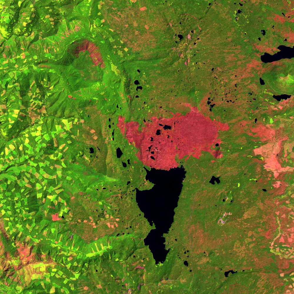
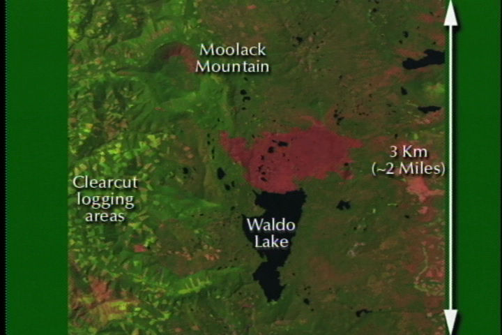
This scene shows a 17-18 mile square area in central Oregon in the Willamette National Forest after forest fires burned through the area in the summer of 1996. The lake in the center of the image is Waldo Lake, located near the Pacific Crest in the Cascade Range. The mountain to the northwest of it (up and to the left in this image) is Moolack Mountain.
The Landsat image was created by combining data from the shortwave infrared (Thematic Mapper (TM) band 5), near infrared (TM band 4) and red (TM band 3) and displaying these bands as red, green, and blue respectively. In this combination, barren exposed land appears red to pink, vegetation appears green, and water is dark blue or black. The light green checkerboard areas are clear cuts in the Willamette National Forest: the dark green is forest, while the light green is light scrub and grass which has grown back in after the area has been clear cut. The pink areas north of Waldo Lake and along the north face of Moolack Mountain are scars from a fire earlier that summer. The Waldo Lake fire burned approximately 10,000 acres while the smaller fire on Moolack Mountain destroyed about 1,000 acres.
Waldo Lake Wilderness Area from Landsat: August 4, 1998
The Landsat image was created by combining data from the shortwave infrared (Thematic Mapper (TM) band 5), near infrared (TM band 4) and red (TM band 3) and displaying these bands as red, green, and blue respectively. In this combination, barren exposed land appears red to pink, vegetation appears green, and water is dark blue or black. The light green checkerboard areas are clear cuts in the Willamette National Forest: the dark green is forest, while the light green is light scrub and grass which has grown back in after the area has been clear cut. The pink areas north of Waldo Lake and along the north face of Moolack Mountain are scars from a fire earlier that summer. The Waldo Lake fire burned approximately 10,000 acres while the smaller fire on Moolack Mountain destroyed about 1,000 acres.
For More Information
Visualization Credits
Please give credit for this item to:
NASA/Goddard Space Flight Center Scientific Visualization Studio
NASA/Goddard Space Flight Center Scientific Visualization Studio
Short URL to share this page:
https://svs.gsfc.nasa.gov/901
Mission:
Landsat
Data Used:
Note: While we identify the data sets used in these visualizations, we do not store any further details nor the data sets themselves on our site.
Keywords:
DLESE >> Natural hazards
DLESE >> Physical geography
SVS >> Waldo Lake Wilderness
GCMD >> Earth Science >> Biosphere >> Ecological Dynamics >> Fire Occurrence
GCMD >> Location >> Oregon
NASA Science >> Earth
GCMD keywords can be found on the Internet with the following citation: Olsen, L.M., G. Major, K. Shein, J. Scialdone, S. Ritz, T. Stevens, M. Morahan, A. Aleman, R. Vogel, S. Leicester, H. Weir, M. Meaux, S. Grebas, C.Solomon, M. Holland, T. Northcutt, R. A. Restrepo, R. Bilodeau, 2013. NASA/Global Change Master Directory (GCMD) Earth Science Keywords. Version 8.0.0.0.0
https://svs.gsfc.nasa.gov/901
Mission:
Landsat
Data Used:
Landsat-5/TM
1998/08/04Keywords:
DLESE >> Natural hazards
DLESE >> Physical geography
SVS >> Waldo Lake Wilderness
GCMD >> Earth Science >> Biosphere >> Ecological Dynamics >> Fire Occurrence
GCMD >> Location >> Oregon
NASA Science >> Earth
GCMD keywords can be found on the Internet with the following citation: Olsen, L.M., G. Major, K. Shein, J. Scialdone, S. Ritz, T. Stevens, M. Morahan, A. Aleman, R. Vogel, S. Leicester, H. Weir, M. Meaux, S. Grebas, C.Solomon, M. Holland, T. Northcutt, R. A. Restrepo, R. Bilodeau, 2013. NASA/Global Change Master Directory (GCMD) Earth Science Keywords. Version 8.0.0.0.0


