Earth
ID: 845
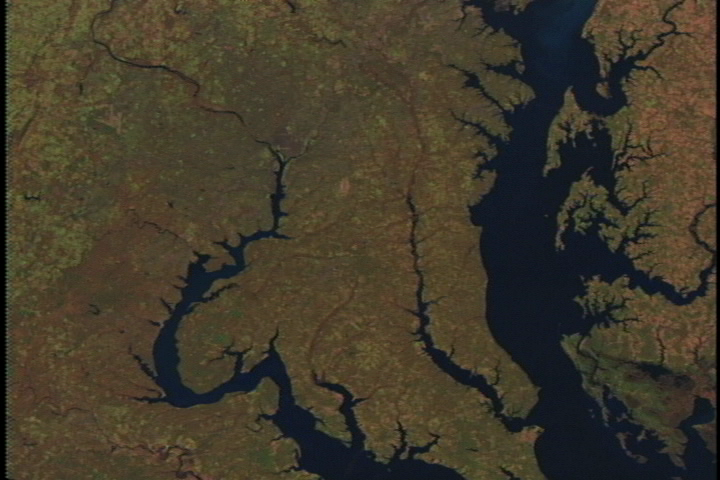
This scene shows Landsat Thematic Mapper data from the shortwave infrared (TM band 5), infrared (TM band 4), and visible green (TM band 2) channels of the Chesapeake Bay. The Patuxent River can be seen running parallel to the Bay on the left, while the Choptank River enters the Bay on the right. Annapolis and Kent Island (flat look-down image) is from the 2nd of October, 1997, all other images are from 16 November, 1996. The change in color between these dates (predominately green in October, red in November) result from seasonal changes in vegetation.


Fly up the Chesapeake Bay to Harrisburg, Pennsylvania
For More Information
Visualization Credits
Please give credit for this item to:
NASA/Goddard Space Flight Center Scientific Visualization Studio
NASA/Goddard Space Flight Center Scientific Visualization Studio
Short URL to share this page:
https://svs.gsfc.nasa.gov/845
Mission:
Landsat
Data Used:
Note: While we identify the data sets used in these visualizations, we do not store any further details nor the data sets themselves on our site.
Keywords:
SVS >> Chesapeake Bay
DLESE >> Human geography
DLESE >> Physical geography
NASA Science >> Earth
https://svs.gsfc.nasa.gov/845
Mission:
Landsat
Data Used:
Landsat-5/TM
1996/11/16, 1997/10/02Keywords:
SVS >> Chesapeake Bay
DLESE >> Human geography
DLESE >> Physical geography
NASA Science >> Earth


